| Previous :: Next Topic |
| Author |
Message |
Quark
Niece of Alvy Moore


Joined: 15 May 2003
Posts: 14152 | TRs | Pics
|
|
Quark
Niece of Alvy Moore
|
 Sun Nov 23, 2008 5:33 pm |
|
|
I havent been on this trail since before the floods of 2003 changed the trail a bit. JimK and I headed up yesterday.
In the late 1990s the Elliot Creek portion of the trail that began at the parking lot was repaired (damaged in the 1980s or in 1990). In 2003, this portion of the trail was again damaged. Actually washed away (we checked it out), so to get to Elliot Cr, you walk the road, then exit a spur trail that meets with the old original trail. Make sense?
Gorgeous trail in a forest of cedar, hemlock and silver fir. I had forgotten about the huge cedars and hemlocks back there. Wow.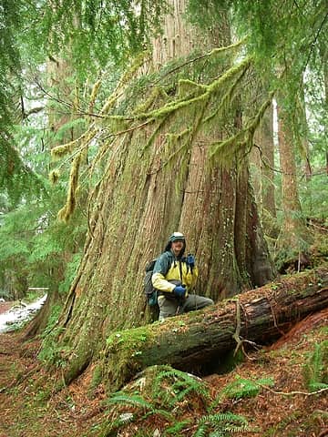 A hiker standing in front of giant cedar 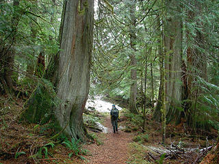 A hiker walks amongst the giants 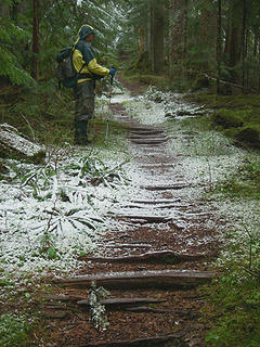 A hiker on old puncheon road 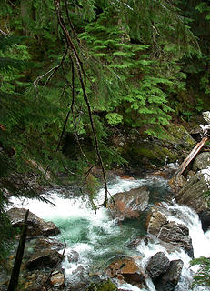 Wild Elliot Creek 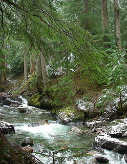 Elliott Cr
"...Other than that, the post was more or less accurate."
Bernardo, NW Hikers' Bureau Chief of Reporting
"...Other than that, the post was more or less accurate."
Bernardo, NW Hikers' Bureau Chief of Reporting
|
| Back to top |
  
|
|
captain jack
Serving suggestion

Joined: 25 May 2004
Posts: 3389 | TRs | Pics
Location: Upper Fidalgo |
| Quark wrote: | | Some blowdown to contend with, and I began to wonder why they closed the trail. Until
it disappeared and we were faced with a cliff. OK, so that answered our question, so we retraced our steps. |
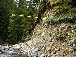 Lower Elliot washout  Depending on the river level, you can walk along the rubble below the slide, and pick up the trail on the other side up high. Since I was coming up from the parking lot when I first discovered this, I walked around it rather than backtracking, because I am that lazy.
| Quote: | | Unfortunately, this closed portion is along the prettiest section of the trail; boulders larger than houses piled up in the creek, which prettily tumbles around them. Definitely worth a look-see (it was too dark for photos). Check it out while you can within a few years, this short section of trail will be under tons and tons of old growth logs that continually fall |
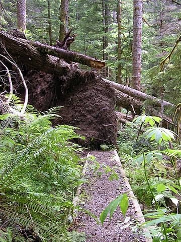 Tree obliterates trail  The whole Elliot Creek trail is a wonderful walk, from start to finish, gurgling sounds and waterfalls, ions to soak up, and big ol trees, it is worth investigating while its still there.
|
| Back to top |
|
|
raising3hikers
Member

Joined: 21 Sep 2007
Posts: 2344 | TRs | Pics
Location: Edmonds, Wa |
That looks like another hike that I would be interested in. I like the big trees and mountains. Thanks for the TR
|
| Back to top |
|
|
Scrooge
Famous Grouse

Joined: 16 Dec 2001
Posts: 6966 | TRs | Pics
Location: wishful thinking |
|
Scrooge
Famous Grouse
|
Sun Nov 23, 2008 8:51 pm |
|
|
Take the trouble to follow the trail/mine road along Elliot Creek, even if you have to work to get around the cliffs and blowdowns. That mile that runs beside the creek is the best streamwalk in Washington, IMHO.
Something lost behind the ranges. Lost and waiting for you....... Go and find it. Go!
Something lost behind the ranges. Lost and waiting for you....... Go and find it. Go!
|
| Back to top |
|
|
JimK
Member

Joined: 07 Feb 2002
Posts: 5606 | TRs | Pics
Location: Ballard |
|
JimK
Member
|
Sun Nov 23, 2008 8:52 pm |
|
|
CJ, thanks for the photo of the washout. I walked out on your blue line in the dark. Your photo gives a good look at what I could not see. I was curious if it might be possible to drop down and climb back up on the other side of the washout.
|
| Back to top |
|
|
touron
Member

Joined: 15 Sep 2003
Posts: 10293 | TRs | Pics
Location: Plymouth Rock |
|
touron
Member
|
Sun Nov 23, 2008 8:57 pm |
|
|
Touron is a nougat of Arabic origin made with almonds and honey or sugar, without which it would just not be Christmas in Spain.
|
| Back to top |
|
|
puzzlr
Mid Fork Rocks

Joined: 13 Feb 2007
Posts: 7220 | TRs | Pics
Location: Stuck in the middle |
|
puzzlr
Mid Fork Rocks
|
Sun Nov 23, 2008 9:40 pm |
|
|
Quark, there's an outhouse-sized shack across the outlet creek right by the lake. Do you know what that is? Has anyone crossed on the logs to check it out?
|
| Back to top |
|
|
Sawyer
Member
|
|
Sawyer
Member
|
Sun Nov 23, 2008 9:46 pm |
|
|
I crossed the creek about 10 years ago. There were remnants of the ol' mining and resort days. The road used to cross the creek on a bridge, and remnants of the ol' road could still be followed. It crossed the creek again. If you recall, there was a resort there and a small road went all the way to the lake.
|
| Back to top |
|
|
Quark
Niece of Alvy Moore
Joined: 15 May 2003
Posts: 14152 | TRs | Pics
|
|
Quark
Niece of Alvy Moore
|
Sun Nov 23, 2008 9:54 pm |
|
|
Puzzlr, JimK suspects that shack has something to do with water gauging. But I'm not so sure a water gauging station needs a building around it. I'm not saying JimK is full of sh## - at least not about the water gauging station - I'm just saying that I don't know the answer to your question.  But here's a curiosity - at a lower switchback on the trail, theres a NF Boundary sign, so I'm thinking there are some private inholdings back there. Leftover mining claims?
captain jack, thanks for the photos. That pic of the tree over the trail must be right after the tree fell - if it's the one I'm thinking of, the rootwad is clean of dirt now. Doesn't make it easier to get around, however. I agree Elliott Creek is a class creek trail; I've said time and time again that it's among the prettiest creek trails around - I had that first 1/2 mile in mind each time I mentioned it - too bad that section is gone. I doubt they have any plans to restore it. The last restoration took 10 years to fund and then build, and it only lasted 4 or 5 years before the creek took it out.
PiB; I looked for the world class rock waterbar - I mentioned it to Jim several times. I don't think it's on the closed section, but beyond. Seems it was in farther. I looked for it, but never saw it - but there are a lot of new sections on the first 1/2 mile of the trail, so it may have been (gasp) taken away, beaut that it was. But here's a curiosity - at a lower switchback on the trail, theres a NF Boundary sign, so I'm thinking there are some private inholdings back there. Leftover mining claims?
captain jack, thanks for the photos. That pic of the tree over the trail must be right after the tree fell - if it's the one I'm thinking of, the rootwad is clean of dirt now. Doesn't make it easier to get around, however. I agree Elliott Creek is a class creek trail; I've said time and time again that it's among the prettiest creek trails around - I had that first 1/2 mile in mind each time I mentioned it - too bad that section is gone. I doubt they have any plans to restore it. The last restoration took 10 years to fund and then build, and it only lasted 4 or 5 years before the creek took it out.
PiB; I looked for the world class rock waterbar - I mentioned it to Jim several times. I don't think it's on the closed section, but beyond. Seems it was in farther. I looked for it, but never saw it - but there are a lot of new sections on the first 1/2 mile of the trail, so it may have been (gasp) taken away, beaut that it was.
"...Other than that, the post was more or less accurate."
Bernardo, NW Hikers' Bureau Chief of Reporting
"...Other than that, the post was more or less accurate."
Bernardo, NW Hikers' Bureau Chief of Reporting
|
| Back to top |
|
|
Magellan
Brutally Handsome

Joined: 26 Jul 2006
Posts: 13116 | TRs | Pics
Location: Inexorable descent |
|
Magellan
Brutally Handsome
|
Sun Nov 23, 2008 10:06 pm |
|
|
I like this one, but have not done it since the lower trail was rebuilt. Now it's regone, so I don't know if I ever will. The upper road was my first mountain bike trail ever. Also my first mountain bike crash. 
|
| Back to top |
|
|
JimK
Member
Joined: 07 Feb 2002
Posts: 5606 | TRs | Pics
Location: Ballard |
|
JimK
Member
|
Sun Nov 23, 2008 10:34 pm |
|
|
Just to be clear, only the first 1/3 or so mile is gone. Most of that can still be walked downstream to the washout if you don't mind crossing a bunch of down logs. The old logging road option is still there but the creek trail is much better in my opinion.
|
| Back to top |
|
|
geobob
Member

Joined: 29 Sep 2007
Posts: 183 | TRs | Pics
Location: seattle |
|
geobob
Member
|
Sun Nov 23, 2008 10:51 pm |
|
|
Wow...just looking at those pics of Goat Lake make me want to throw another blanket on my bed!
I think there's an easier way on the far side
I think there's an easier way on the far side
|
| Back to top |
|
|
Hiker Mama
Member

Joined: 25 Jun 2006
Posts: 3451 | TRs | Pics
Location: Lynnwood |
Wow, look at those big ol' trees! And the lake looks pretty cold.
|
| Back to top |
|
|
|
|


