| Previous :: Next Topic |
| Author |
Message |
Ancient Ambler
Member


Joined: 15 May 2007
Posts: 1092 | TRs | Pics
Location: Bainbridge Island |
Hoping for snow-free access to the high country, took off for the Upper Maynard Burn trail under sunny skies. One other car was at the TH when we reached it and temperatures were already balmy. Hiking in T shirt and shorts was a very welcome change from the awful conditions of so many outings so far this year, especially the heavy wind, rain, and fog I experienced summiting Mt. Baker a couple weeks ago. There are a couple ways up to Baldy from the road end, and we chose the steeper Upper Maynard Burn way trail instead of the slightly more moderate Tyler Peak way trail. From the road end, Upper Maynard Burn way trail is accessed by following the washed out logging road a few hundred yards past Mueller Creek, then hanging a right where the trail parallels the road for a few hundred feet before taking off uphill. Beware of very slippery rocks crossing Mueller Creek. Shortly past the creek crossing, the old road is very overgrown with alder saplings in need of clearing. If you're heading this way and feeling charitable, bring some loppers.
The trail gains about 300 feet between switchbacks in the logging road, at which point the trail steepens in earnest. From here to where the trail peters out in meadows below the Tyler-Baldy ridge, the trail is in good shape, with the exception of clumps of one-foot diameter blowdowns at about 5100 and 5300 feet that require detouring off the trail for a ways. A nice bunch of blooming rhodies at around 4600 feet. Only one patch of snow about 10 feet wide across the trail in the trees before the trail breaks out into the open terrain of Mueller meadow. There was water running in the west fork of Meueller creek where the trail crosses it and no snow to cross all the way up to Tyler-Baldy ridge. Tyler Peak access looks snow-free as well.
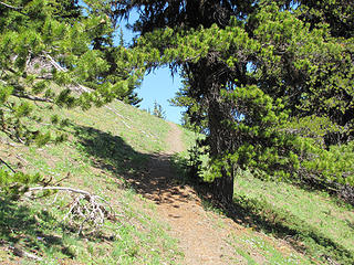 Upper Maynard Burn trail at about 5800 ft 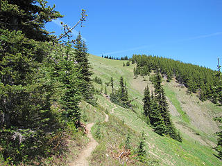 Trail toward Tyler-Baldy ridge 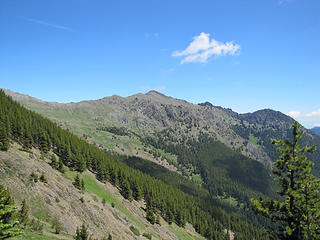 Tyler Peak 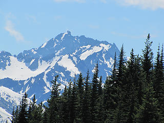 Constance 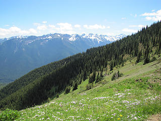 upper Mueller meadows 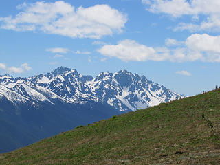 Constance and Inner Constance from Tyler-Baldy ridge 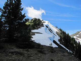 false summit 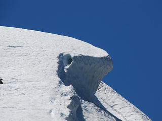 Cornice near false summit 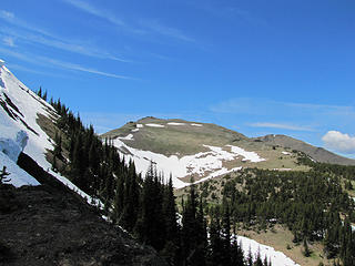 Baldy from Tyler-Baldy ridge 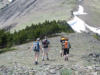 Ridge walk toward summit 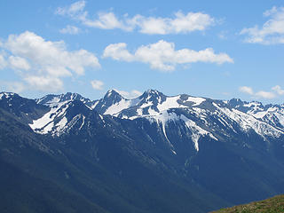 Buckhorn 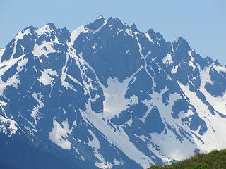 North face of Inner Constance 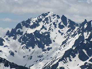 Mount Deception 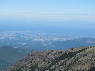 Sequim and the Straits 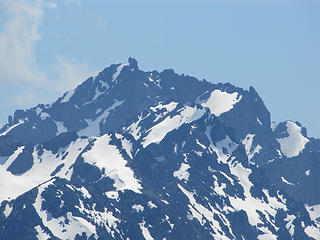 4 labels Constance, Warrior, Alphabet Ridge 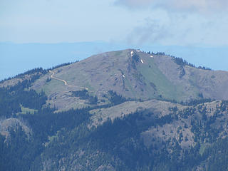 Blue Mountain 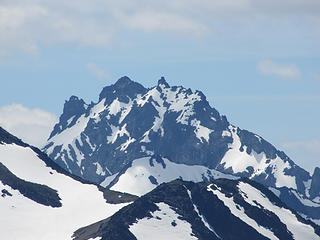 Mount Mystery 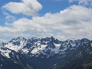 Mt. Deception and The Needles 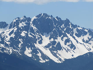 Inner Constance 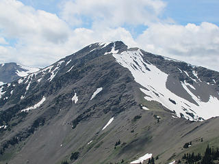 Gray Wolf Mountain 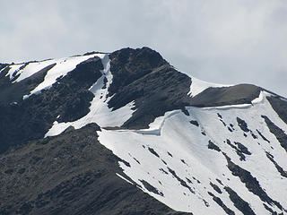 Gray Wolf Mountain summit approach
|
| Back to top |
  
|
|
kite
Member

Joined: 28 Sep 2009
Posts: 1416 | TRs | Pics
Location: Olympia |
|
kite
Member
|
 Sun Jul 11, 2010 9:32 am |
|
|
thank you for the timely report had been thinking about Baldy... looks like you had a nice day
|
| Back to top |
|
|
half fast
member

Joined: 21 Mar 2010
Posts: 1392 | TRs | Pics
Location: Living the dream in my 5th Wheel |
Great TR and wonderful photos...  Looks like a very fun day in the mountains... and sounds like a good work out as well !!
Thanks for sharing
Looks like a very fun day in the mountains... and sounds like a good work out as well !!
Thanks for sharing
It's all about the fun, oh and maybe the chocolate - half fast
It's all about the fun, oh and maybe the chocolate - half fast
|
| Back to top |
|
|
Redwic
Unlisted Free Agent

Joined: 23 Feb 2009
Posts: 3292 | TRs | Pics
Location: Going to the Prom(inence) |
|
Redwic
Unlisted Free Agent
|
Tue Jul 13, 2010 8:19 am |
|
|
I have tomorrow off from work, so I am considering attempting Gray Wolf Ridge (7218') from Baldy. The photos on this trip report seem to indicate only one sketchy section of snow on the ridgetop en route to the Gray Wolf summit. I wonder if I can safely side-traverse that section, or hike down/up loose scree around it. I was hoping not to need bringing my ice axe, especially for such a small section, but it is better to be safe than sorry.
Any advice, fellow NWHers?
60 pounds lighter but not 60 points brighter.
60 pounds lighter but not 60 points brighter.
|
| Back to top |
|
|
Trailhead
PCT Class of 2012

Joined: 25 Jul 2007
Posts: 445 | TRs | Pics
Location: PDX |
|
Trailhead
PCT Class of 2012
|
Tue Jul 13, 2010 9:38 am |
|
|
| Redwic wrote: | | I was hoping not to need bringing my ice axe, especially for such a small section, but it is better to be safe than sorry.
Any advice, fellow NWHers? |
We are hoping you bring your axe and don't need to use it. I have not done this route but the snow on the ridgeline looks doable to me if its warm enough.
I carried one up Mt Christie this weekend in the warm weather. Lots off soft wet snow on the N side in the hot weather. Never used the ice axe.
|
| Back to top |
|
|
Redwic
Unlisted Free Agent
Joined: 23 Feb 2009
Posts: 3292 | TRs | Pics
Location: Going to the Prom(inence) |
|
Redwic
Unlisted Free Agent
|
Tue Jul 13, 2010 12:17 pm |
|
|
I was planning to bring it, just in case of bad snow conditions on the ridgetop. Besides, the extra weight to carry will make for a better workout!
60 pounds lighter but not 60 points brighter.
60 pounds lighter but not 60 points brighter.
|
| Back to top |
|
|
Redwic
Unlisted Free Agent
Joined: 23 Feb 2009
Posts: 3292 | TRs | Pics
Location: Going to the Prom(inence) |
|
Redwic
Unlisted Free Agent
|
Wed Jul 14, 2010 6:36 pm |
|
|
UPDATE: I did Baldy, Gray Wolf, Peak B, and Tyler Peak today.
Each peak is now very doable, with no traverse issues (other than the standard loose scree and dirt in places). There is one snow-covered saddle near the summit block of Gray Wolf. I used my ice axe for that section, but it really was not necessary... the snow was a gentle angle and had a lot of runoff (in case of a fall). There are other small snow patches and ridges with cornices, but those can be avoided.
Gray Wolf was my 23rd WA CoHP. Great weather & views!!
60 pounds lighter but not 60 points brighter.
60 pounds lighter but not 60 points brighter.
|
| Back to top |
|
|
RodF
Member

Joined: 01 Sep 2007
Posts: 2593 | TRs | Pics
Location: Sequim WA |
|
RodF
Member
|
Thu Jul 22, 2010 1:49 pm |
|
|
| Ancient Ambler wrote: | | Shortly past the creek crossing, the old road is very overgrown with alder saplings in need of clearing. If you're heading this way and feeling charitable, bring some loppers. |
Done last week.
(Actually, cleared the path along the entire decommissioned -120 spur road to the lower Maynard Burn trail junction, which drops down to Royal Creek trail. Some do use this as a shortcut to Royal, or following Wood's book, walk the old road to get to the upper Maynard Burn trail. It had gotten rather badly overgrown in the 3 years since i'd last been there!)
"of all the paths you take in life, make sure a few of them are dirt" - John Muir
"the wild is not the opposite of cultivated. It is the opposite of the captivated - Vandana Shiva
"of all the paths you take in life, make sure a few of them are dirt" - John Muir
"the wild is not the opposite of cultivated. It is the opposite of the captivated - Vandana Shiva
|
| Back to top |
|
|
reststep
Member

Joined: 17 Dec 2001
Posts: 4757 | TRs | Pics
|
|
reststep
Member
|
Thu Jul 22, 2010 8:46 pm |
|
|
Thanks Rod for the trail work and thank you AA for the trip report and pictures.
"The mountains are calling and I must go." - John Muir
"The mountains are calling and I must go." - John Muir
|
| Back to top |
|
|
|
|


