| Previous :: Next Topic |
| Author |
Message |
raising3hikers
Member


Joined: 21 Sep 2007
Posts: 2344 | TRs | Pics
Location: Edmonds, Wa |
Mt. Spickard 8979'
Mt. Rahm 8480'
Mt. Custer 8630'
With a good forecast for the North Cascades, I went to a place I've never been to before. I had a trip planned in the Chilliwacks a week before but there weather said otherwise. On Friday evening, I left for Canada to go the Lk Chilliwack area to get to the Depot Cr rd. Like many reports before, that road has a bunch of pot holes! I can't see how a car can do it. There were two other vehicles at the "parking area" before the high clearance road kept going.
I woke early Saturday morning and hiked the remaining road towards the border. It was easy and straight forward. I soon made my way back into Washington on the Depot Cr trail. It was an old growth forest trail that was easy to follow despite the occasional down tree.
 Depot Creek 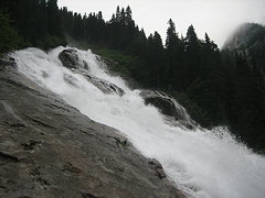 Depot Creek Falls  small streams and greenery  the fog clearing as the glaciers descend from the mountains  the Moxes  Redoubt  Hard Mox  the Pickets above the ridge East of SE Mox  Devil's Tongue above Silver Lake 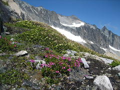 Mt Rahm above a few flowers  Mt Spickard above Silver Lake 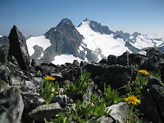 a little flower garden on the ridge  a look at Custer  my Custer summit shot  the Moxes  camp in the cirque 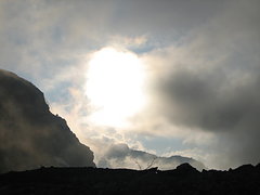 clouds forming before sunset
|
| Back to top |
  
|
|
Hiker Mama
Member

Joined: 25 Jun 2006
Posts: 3451 | TRs | Pics
Location: Lynnwood |
Wow!!!  Look at that gorgeous scenery. What a fantastic trip! Look at that gorgeous scenery. What a fantastic trip!
|
| Back to top |
|
|
Tom_Sjolseth
Born Yesterday

Joined: 30 May 2007
Posts: 2652 | TRs | Pics
Location: Right here. |
One of my favorite areas in the range! Nice work on the trifecta on approach day.
|
| Back to top |
|
|
Backpacker Joe
Blind Hiker

Joined: 16 Dec 2001
Posts: 23956 | TRs | Pics
Location: Cle Elum |
You guys are awesome!
"If destruction be our lot we must ourselves be its author and finisher. As a nation of freemen we must live through all time or die by suicide."
Abraham Lincoln
"If destruction be our lot we must ourselves be its author and finisher. As a nation of freemen we must live through all time or die by suicide."
Abraham Lincoln
|
| Back to top |
|
|
Jetlag
Member
Joined: 17 Aug 2010
Posts: 1410 | TRs | Pics
|
|
Jetlag
Member
|
 Sun Jul 29, 2012 9:30 pm |
|
|
Excellent photos - especially Silver Lake and Spickard seen from Rahm.
After reading this, I reluctantly admit it took me three days in just to climb Easy Mox.
|
| Back to top |
|
|
Magellan
Brutally Handsome

Joined: 26 Jul 2006
Posts: 13117 | TRs | Pics
Location: Inexorable descent |
|
Magellan
Brutally Handsome
|
Sun Jul 29, 2012 9:53 pm |
|
|
Outstanding! 
|
| Back to top |
|
|
Jim Dockery
Member

Joined: 12 Sep 2007
Posts: 3092 | TRs | Pics
Location: Lake Stevens |
Yowza, good day on ya! Nice pics too, thanks for the TR. I've never been in there and have to add it to my list. I think I'll take a few days to enjoy the views 
|
| Back to top |
|
|
twodogdad
Member
Joined: 21 Nov 2006
Posts: 846 | TRs | Pics
Location: seattle |
I thought you did that loop in 3 days (which would be more than reasonable); then I re-read the TR. You actually did it in one day (driving time excluded). And you even had time to take some excellent photos--and ponder the inscrutable moods of mountain goats. Unbelievable tdd
|
| Back to top |
|
|
iron
Member

Joined: 10 Aug 2008
Posts: 6392 | TRs | Pics
Location: southeast kootenays |
|
iron
Member
|
Sun Jul 29, 2012 10:44 pm |
|
|
good stuff. glad you snuck these into the weather window. you're closing in on 100 fast! 9300' on the first day? probably still had another 5k in you... 
|
| Back to top |
|
|
b00
Member

Joined: 29 Sep 2003
Posts: 1144 | TRs | Pics
|
|
b00
Member
|
Sun Jul 29, 2012 11:33 pm |
|
|
| iron wrote: | | good stuff. glad you snuck these into the weather window. you're closing in on 100 fast! 9300' on the first day? probably still had another 5k in you... |
only 5k more?
what was the word about conditions on spickard and redoubt?
were you able to avoid the brush on the way to ouzel lake?
:>)
|
| Back to top |
|
|
puzzlr
Mid Fork Rocks

Joined: 13 Feb 2007
Posts: 7220 | TRs | Pics
Location: Stuck in the middle |
|
puzzlr
Mid Fork Rocks
|
Mon Jul 30, 2012 1:09 am |
|
|
What was that blur when I blinked? r3h of course.
|
| Back to top |
|
|
Jetlag
Member
Joined: 17 Aug 2010
Posts: 1410 | TRs | Pics
|
|
Jetlag
Member
|
Mon Jul 30, 2012 6:21 am |
|
|
Boo, 2 years ago we found a valley-size rockslide had covered 95 percent of the brush to Ouzel lake.
|
| Back to top |
|
|
silence
Member

Joined: 25 Apr 2005
Posts: 4420 | TRs | Pics
|
|
silence
Member
|
Mon Jul 30, 2012 8:22 am |
|
|
You blow me away Eric .. way to go!!!!
PHOTOS
FILMS
Keep a good head and always carry a light bulb. Bob Dylan
PHOTOS
FILMS
Keep a good head and always carry a light bulb. Bob Dylan
|
| Back to top |
|
|
mike
Member
Joined: 09 Jul 2004
Posts: 6400 | TRs | Pics
Location: SJIsl |
|
mike
Member
|
Mon Jul 30, 2012 9:44 am |
|
|
| raising3hikers wrote: | | on the Depot Cr trail... It was easy and straight forward...Good thing there were hand lines along this part. |
Where was that trail when we went up there?? Instead of 10' deep slide alder. Hasn't been that long..or has it?
|
| Back to top |
|
|
Stefan
Member

Joined: 17 Dec 2001
Posts: 5093 | TRs | Pics
|
|
Stefan
Member
|
Mon Jul 30, 2012 12:36 pm |
|
|
| raising3hikers wrote: | | I felt like I was going slow at this point... |
This quote does not compute!!!
Glad you had a great time!
|
| Back to top |
|
|
|
|


