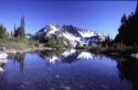
We are planning a 5 day hike in the Glacier Peak Wilderness this summer and are looking for a good topo map of the area (that would include Spider Gap, Lyman Lakes, Suiattle Pass and Buck Creek Pass). A book that gives miles, elevation gain, and detailed tail descriptions would also be great. Any recommendations?
Thank you!
Try 100 Hikes in Washington's Glacier Peak Region: The North Cascades (100 Hikes in Washington's Glacier Peak Region) by Ira Spring and Harvey Manning. It has the areas you are interested in.
Geo-Graphics makes a map of Glacier Peak Wilderness that is 1:100,000 for the entire wilderness on one side and 1:30,000 around Glacier Peak itself. I found this map at Metzker Maps in Seattle, but I have also seen it at REI.
You cannot post new topics in this forum You cannot reply to topics in this forum You cannot edit your posts in this forum You cannot delete your posts in this forum You cannot vote in polls in this forum
Disclosure: As an Amazon Associate NWHikers.net earns from qualifying purchases when you use our link(s).