| Previous :: Next Topic |
| Author |
Message |
dicey
custom title


Joined: 11 May 2004
Posts: 2869 | TRs | Pics
Location: giving cornices a wider berth |
|
dicey
custom title
|
 Mon Jul 25, 2005 10:22 pm |
|
|
Many lessons were learned on this trip  The first lesson is a) always bring a real rain jacket backpacking in NCNP no matter what month it is.
The weather report looked stellar for fri-sun, until friday morning. Luckily, I did a quick check in the morning before my ride arrived, and swapped out my flimsy lightweight rain shell for the goretex one at the last possible moment.
Laurie, Karen, Anne and myself, drove to the Marblemount ranger station to secure our permits for 2 nights in horseshoe basin. No problem, but we can only camp in upper horseshoe basin. Ok, we'll have to take our full packs up there. Not a big deal, since our objective was Buckner.
We arrived at Cascade Pass trailhead in the rain. We actually sat in the car for an hour, hoping it would let up, but it didn't.
We sloshed up to the pass (no views), and down the other side, heading for the turn off to Horseshoe Basin.
Lesson b) make sure you are not the only one with a map, and if for some reason you are, make sure the plastic bag holding the map does not have holes in it.
The first lesson is a) always bring a real rain jacket backpacking in NCNP no matter what month it is.
The weather report looked stellar for fri-sun, until friday morning. Luckily, I did a quick check in the morning before my ride arrived, and swapped out my flimsy lightweight rain shell for the goretex one at the last possible moment.
Laurie, Karen, Anne and myself, drove to the Marblemount ranger station to secure our permits for 2 nights in horseshoe basin. No problem, but we can only camp in upper horseshoe basin. Ok, we'll have to take our full packs up there. Not a big deal, since our objective was Buckner.
We arrived at Cascade Pass trailhead in the rain. We actually sat in the car for an hour, hoping it would let up, but it didn't.
We sloshed up to the pass (no views), and down the other side, heading for the turn off to Horseshoe Basin.
Lesson b) make sure you are not the only one with a map, and if for some reason you are, make sure the plastic bag holding the map does not have holes in it. 
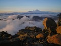
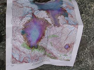 wrecked map 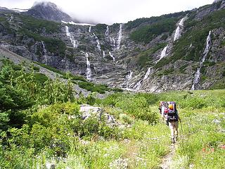 horseshoe basin 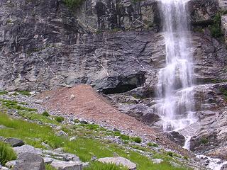 mine  At this point, we were running out of time for anymore screwing around, and needed to get to camp. So we gave up for the evening, resolving to solve this puzzle in the morning with lighter packs
  I could go on for a long time about the various route finding skirmishes and vertical brush jungle gyms/waterfall slab playgrounds we encountered saturday morning, but in the end, we were unable to gain upper horseshoe basin.
Now we were really in a pickle. We had a permit for upper horseshoe basin for tonight, but no realistic way to get there. We considered our options which were to 1) bail completely, hike back to the cars and try to get a permit for somewhere else(lame), 2) go home(really lame), 3) continue with our current trend of becoming the scourge of the North Cascades - unwilling rogues, if you will (kinda lame and illegal - therefore somewhat appealing).
So we headed back to Cascade Pass, stopping for a refreshing dip in doubtful creek along the way. Upon reaching the pass, we acquiesced to the hordes and their constant demands of, "could you take my picture?" over and over.
We fairly ran up the trail past the bathrooms (side note here - on the way back, Karen stopped to use this privy, only to happen upon a goat with it's head stuck down inside it. She decided to hold it )
We followed the beaten path below Mix Up, crossing some streams and some ugly steep dirt/rock gullies, marveling at the views of Eldorado, Torment, Forbidden, Sahale, Ripsaw ridge and stupid Buckner. We saw a herd of about 6 or 7 goats and a kid - cute!
I could go on for a long time about the various route finding skirmishes and vertical brush jungle gyms/waterfall slab playgrounds we encountered saturday morning, but in the end, we were unable to gain upper horseshoe basin.
Now we were really in a pickle. We had a permit for upper horseshoe basin for tonight, but no realistic way to get there. We considered our options which were to 1) bail completely, hike back to the cars and try to get a permit for somewhere else(lame), 2) go home(really lame), 3) continue with our current trend of becoming the scourge of the North Cascades - unwilling rogues, if you will (kinda lame and illegal - therefore somewhat appealing).
So we headed back to Cascade Pass, stopping for a refreshing dip in doubtful creek along the way. Upon reaching the pass, we acquiesced to the hordes and their constant demands of, "could you take my picture?" over and over.
We fairly ran up the trail past the bathrooms (side note here - on the way back, Karen stopped to use this privy, only to happen upon a goat with it's head stuck down inside it. She decided to hold it )
We followed the beaten path below Mix Up, crossing some streams and some ugly steep dirt/rock gullies, marveling at the views of Eldorado, Torment, Forbidden, Sahale, Ripsaw ridge and stupid Buckner. We saw a herd of about 6 or 7 goats and a kid - cute!
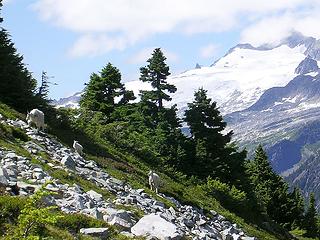 goats and eldorado 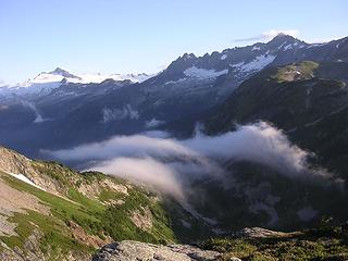 eldorado, torment, forbidden and sahale arm 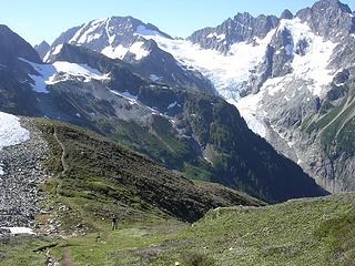 heading towards kool aid lake from cache col
|
| Back to top |
  
|
|
Tazz
Member

Joined: 27 Apr 2005
Posts: 7902 | TRs | Pics
|
|
Tazz
Member
|
Tue Jul 26, 2005 12:32 am |
|
|
|
| Back to top |
|
|
Jeff R
Closet hiker.
Joined: 10 Apr 2005
Posts: 972 | TRs | Pics
Location: Everret |
|
Jeff R
Closet hiker.
|
Tue Jul 26, 2005 5:02 am |
|
|
I really like the way you compiled your report, real nice! A+ 
|
| Back to top |
|
|
Stuart
Member
Joined: 24 Oct 2004
Posts: 128 | TRs | Pics
Location: Bellevue, WA |
|
Stuart
Member
|
Tue Jul 26, 2005 5:13 am |
|
|
Thanks
|
| Back to top |
|
|
Don
Member

Joined: 25 Apr 2005
Posts: 2013 | TRs | Pics
Location: Fairwood, WA |
|
Don
Member
|
Tue Jul 26, 2005 7:33 am |
|
|
Nice TR Dicey. Sorry to hear about your Horseshoe Basin experience. I got stuck in Upper Horseshoe Basin once, unable to find a route down! I had traversed over from Sahale. I finally got down, but was too far to the east and was downclimbing class 4 and low class 5 rock with a full pack (1 week trip, to exit Thunder Creek). I kissed the trail when I finally got down.
A couple of yeas ago I went back and climbed Buckner again, but approached via Horseshoe. It was sunny and I found the walk-up route with no problem, east of the creek. I think I did it in late August, so conditions may have been different for me. Don't give up - it's there! (Beckey says to look for the old cable - don't do it!)
Anyway, doesn't sound like you suffered too much after getting to see the first stage of the PT!
|
| Back to top |
|
|
mike
Member
Joined: 09 Jul 2004
Posts: 6400 | TRs | Pics
Location: SJIsl |
|
mike
Member
|
Tue Jul 26, 2005 10:31 am |
|
|
I've camped in the lower basin too. Really sucks as there isn't a level boulder free brush free spot in the whole place. Didn't get to the upper basin that trip either. We were coming from Thunder Ck. On a later trip we found a route farther to the east than the place it sounds like you tried. Still our route up wasn't a walk up and would be difficult with full packs. If Don says a walk up route exists I believe him but we sure didn't find it. We were earlier in the year so maybe that matters. The skree slope below the summit wouldn't be any fun late in the year I think.
|
| Back to top |
|
|
Don
Member
Joined: 25 Apr 2005
Posts: 2013 | TRs | Pics
Location: Fairwood, WA |
|
Don
Member
|
Tue Jul 26, 2005 10:45 am |
|
|
Good point Mike - I should clarify "walk up" to be class 2 IMO. The route gets easier and more obvious the further you climb. I camped on the snow in the upper reaches of the upper basin to avoid the bear problems of my previous visit, and had snow all the way up to the bare summit ridge. I can't imagine climbing Buckner in scree either - yuk.
|
| Back to top |
|
|
mike
Member
Joined: 09 Jul 2004
Posts: 6400 | TRs | Pics
Location: SJIsl |
|
mike
Member
|
Tue Jul 26, 2005 1:17 pm |
|
|
Yeah, a class 2 would be great. Our route was a class 4 maybe a section of 5 especially considering the wet miserable rock. Lots of vegetative belays. Probably to the right of dicey's photo but it's hard to tell.
|
| Back to top |
|
|
dicey
custom title
Joined: 11 May 2004
Posts: 2869 | TRs | Pics
Location: giving cornices a wider berth |
|
dicey
custom title
|
Tue Jul 26, 2005 1:50 pm |
|
|
Here are a couple of shots of the 'route', for clarification
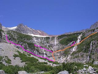 purple = routes we tried that didn't work. orange = route i think would work 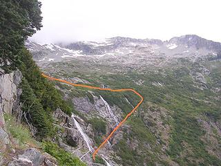 taken from waterfall to the left of the mine
|
| Back to top |
|
|
Don
Member
Joined: 25 Apr 2005
Posts: 2013 | TRs | Pics
Location: Fairwood, WA |
|
Don
Member
|
Tue Jul 26, 2005 2:24 pm |
|
|
Dicey,
I have drawn what I believe the route to be into your pic (yep, I desecrated it). I wish I could see the slope after the furthest waterfall to the right to be certain. But I believe this to be correct.
You leave the trail a few hundred feet before the mine and cross the creek for the proper route, coming out on the eastern side of the upper basin.
The brush in the center of the pic is where the cable is that Beckey refers to. It is a jungle in there.
|
| Back to top |
|
|
dicey
custom title
Joined: 11 May 2004
Posts: 2869 | TRs | Pics
Location: giving cornices a wider berth |
|
dicey
custom title
|
Tue Jul 26, 2005 9:17 pm |
|
|
Wow, that is way farther east than I would have even thought to look!! Thank you guys for your insight into my bumbling, route finding faceplants.
Maybe I'll go back with a read-able map sometime! I honestly don't know what we would have done if we had gotten up there with that mess of a map.
Probably would have ended up climbing something else altogether anyway
I think everyone in the group was happy to bail and end up in the beautiful place we did.
I almost forgot....
Last lesson learned on this adventure: A broken toe apparently takes more than 3 days to heal 
|
| Back to top |
|
|
wbs
member
Joined: 11 Aug 2003
Posts: 661 | TRs | Pics
Location: Kirkland WA |
|
wbs
member
|
Tue Jul 26, 2005 10:48 pm |
|
|
What timing!
I have a 4 day wkend coming up and had been wrestling with that all too common so much to see where to go syndrome.
Prospects in no particular order
a.) Horseshoe Basin
b.) Shucksan Arm
c.) Boston Basin
d.) somewhere off in the far reaches of Pasayten
Thanks Dicey  I think you just may have made my decision for me
|
| Back to top |
|
|
Don
Member
Joined: 25 Apr 2005
Posts: 2013 | TRs | Pics
Location: Fairwood, WA |
|
Don
Member
|
Wed Jul 27, 2005 7:22 am |
|
|
| Quote: | | I honestly don't know what we would have done if we had gotten up there with that mess of a map. |
You would have been successful! The upper basin is open and the route obvious. Only one challenge would present itself; getting back down!
|
| Back to top |
|
|
|
|
You cannot post new topics in this forum
You cannot reply to topics in this forum
You cannot edit your posts in this forum
You cannot delete your posts in this forum
You cannot vote in polls in this forum
|
Disclosure: As an Amazon Associate NWHikers.net earns from qualifying purchases when you use our link(s). |


 had to laugh

