| Previous :: Next Topic |
| Author |
Message |
obladi
Member


Joined: 26 Sep 2003
Posts: 129 | TRs | Pics
Location: Portland Oregon |
|
obladi
Member
|
 Sat Jul 30, 2005 8:26 pm |
|
|
I am planning a 4 day backpacking trip next thursday thru sunday. I am thinking roughly 45-60 miles in either ONP, NCSP or Goat Rocks. I really would like to see and photograph wildlife. Any recommendations? I loved enchanted Valley and am thinking about making a loop up past O'neil pass to six ridge primitive trail and back down Sundown pass. Anyhow any input would be greatly appreciated. It will be solo so I am up for going on the expedition with someone however I will be a bit picky about the trail.
As you push off from the shore, won't you turn your head once more, to make your peace with everyone
And for those who choose to stay, You'll live for one more day, to do the things you should have done.
-Ian Anderson
As you push off from the shore, won't you turn your head once more, to make your peace with everyone
And for those who choose to stay, You'll live for one more day, to do the things you should have done.
-Ian Anderson
|
| Back to top |
  
|
|
Slugman
Its a Slugfest!

Joined: 27 Mar 2003
Posts: 16874 | TRs | Pics
|
|
Slugman
Its a Slugfest!
|
Sun Jul 31, 2005 12:03 am |
|
|
I can't think of a nicer loop than that one, or a harder one. It TOPO!s out at 55 miles and 16,500 ft gain/loss. If you were planning on ten days instead of four, I might offer to join you!  TOPO! info based on a route up Quinault to O'Neil pass junction, Hart lake and lake La Crosse, down to Duckabush, then First Divide, Skokomish, Six ridge, out via Graves creek. It's a true loop, with no retracing or overlapping except the short side trips to Hart/La Crosse. Add in a trip to Anderson glacier, and it's 60 miles and 18,500 VF.
If you do that one, please write a trip report (or PM me) that includes any trail or bridge issues that would stop an ordinary trail hiker. That sounds like a dream loop for me to attempt someday.... Some lonely country up there, and beautiful, too, from what little I've seen of it (Anderson pass/glacier, La Crosse pass)
TOPO! info based on a route up Quinault to O'Neil pass junction, Hart lake and lake La Crosse, down to Duckabush, then First Divide, Skokomish, Six ridge, out via Graves creek. It's a true loop, with no retracing or overlapping except the short side trips to Hart/La Crosse. Add in a trip to Anderson glacier, and it's 60 miles and 18,500 VF.
If you do that one, please write a trip report (or PM me) that includes any trail or bridge issues that would stop an ordinary trail hiker. That sounds like a dream loop for me to attempt someday.... Some lonely country up there, and beautiful, too, from what little I've seen of it (Anderson pass/glacier, La Crosse pass)
|
| Back to top |
|
|
hikermike
Member

Joined: 24 Jun 2003
Posts: 1238 | TRs | Pics
Location: Tacoma |
How are you going to hike 45-60 miles in 4 days AND take pix of wildlife?
|
| Back to top |
|
|
obladi
Member
Joined: 26 Sep 2003
Posts: 129 | TRs | Pics
Location: Portland Oregon |
|
obladi
Member
|
Sun Jul 31, 2005 7:15 pm |
|
|
| Quote: | | How are you going to hike 45-60 miles in 4 days AND take pix of wildlife? |
hike long days I guess.
I am thinking the sixridge route may be a bad idea as the ONP website said the trail is hard to follow from McGravey Lakes to Bellview. Since I have to open a store at 6:30 am in Portland the morning after day 4 it might not be the safest bet. I will have to call the park and find out exactly what the condition is. I could still go to Duckabush and back or maybe a Skyline trail loop.
As you push off from the shore, won't you turn your head once more, to make your peace with everyone
And for those who choose to stay, You'll live for one more day, to do the things you should have done.
-Ian Anderson
As you push off from the shore, won't you turn your head once more, to make your peace with everyone
And for those who choose to stay, You'll live for one more day, to do the things you should have done.
-Ian Anderson
|
| Back to top |
|
|
ActionBetty
Im a dirty hippie!

Joined: 06 Jul 2003
Posts: 4807 | TRs | Pics
Location: kennewick, wa |
|
ActionBetty
Im a dirty hippie!
|
Sun Jul 31, 2005 8:26 pm |
|
|
I was just in the Goat Rocks wilderness , plenty of trails, plenty of wildlife. ..mainly deer for me..but lots of them. You really have to get up early and hit the watering areas to catch them in small herds..or right at dusk.
"If you're not living good, you gotta travel wide"...Bob Marley
"If you're not living good, you gotta travel wide"...Bob Marley
|
| Back to top |
|
|
Slugman
Its a Slugfest!

Joined: 27 Mar 2003
Posts: 16874 | TRs | Pics
|
|
Slugman
Its a Slugfest!
|
Sun Jul 31, 2005 9:21 pm |
|
|
If you didn't mind doing a "lolipop" loop, you could go up the Quinault, head over O'Neil pass, see Hart and La Crosse lakes, down to Duckabush, over La Crosse pass to Honeymoon meadows, over Anderson pass with side trip to Anderson glacier, then back out the Quinault. This would shorten the loop's elevation gain by a full mile, and give you nice stuff to see (La Crosse pass area and Anderson Glacier) to compensate you for the loss of the Sixridge area and the return out Graves creek, plus two trips through the Enchanted valley for your chance to photograph bears and/or elk.
Old loop stats including Anderson Glacier and Sixridge return: 60 mi, 18,500 ft.
New "lolipop" loop stats: 58 miles, 13,500 ft.
I was surprised the loop wasn't really any shorter distance-wise. The old loop was too much for me even assuming ten days, with an average gain of 1,850 ft per day, way more than that on climbing days, since some days are all downhill and so no climbing is done. The new loop looks like a possibility for me. The average of 1,350 ft/day is reasonable. Even if you assume two rest days, the averages for 8 days hiking are 7.25 miles, 1,700 vf. That's 14.5 miles, 3,400 vf average for Obladi's four day trip. The good news: it's all on real trails, except the boulder field scramble to Anderson glacier from the glacier overlook.
|
| Back to top |
|
|
obladi
Member
Joined: 26 Sep 2003
Posts: 129 | TRs | Pics
Location: Portland Oregon |
|
obladi
Member
|
Sun Jul 31, 2005 10:55 pm Lollipop loop
|
|
|
The Lollipop loop sounds great actually. Thanks Slugman!! Providing it will not downpour that sounds like a very good itineray that seems to be my #1 option at this point.
As you push off from the shore, won't you turn your head once more, to make your peace with everyone
And for those who choose to stay, You'll live for one more day, to do the things you should have done.
-Ian Anderson
As you push off from the shore, won't you turn your head once more, to make your peace with everyone
And for those who choose to stay, You'll live for one more day, to do the things you should have done.
-Ian Anderson
|
| Back to top |
|
|
Slugman
Its a Slugfest!

Joined: 27 Mar 2003
Posts: 16874 | TRs | Pics
|
|
Slugman
Its a Slugfest!
|
Sun Jul 31, 2005 11:50 pm |
|
|
I did a very careful tracing of the route in TOPO!, and saved it, since I plan to do that hike in the future, maybe next year, or whenever I can get the ten days off. If you'd like, I can convert the maps to jpegs and PM them to you, or upload them to flickr and post them here. It's no trouble, takes a couple of minutes max.
|
| Back to top |
|
|
obladi
Member
Joined: 26 Sep 2003
Posts: 129 | TRs | Pics
Location: Portland Oregon |
|
obladi
Member
|
Mon Aug 01, 2005 12:26 am |
|
|
Either one would be awesome! Thanx ... I promise to post a trip report for when I get back whichever one I decide to do.
Thanx
As you push off from the shore, won't you turn your head once more, to make your peace with everyone
And for those who choose to stay, You'll live for one more day, to do the things you should have done.
-Ian Anderson
As you push off from the shore, won't you turn your head once more, to make your peace with everyone
And for those who choose to stay, You'll live for one more day, to do the things you should have done.
-Ian Anderson
|
| Back to top |
|
|
Slugman
Its a Slugfest!

Joined: 27 Mar 2003
Posts: 16874 | TRs | Pics
|
|
Slugman
Its a Slugfest!
|
Mon Aug 01, 2005 1:08 am |
|
|
OK, here goes. I haven't done this before with TOPO! maps, and I'm new to flickr, so we'll see what happens.
Section 1 is 14.56 miles, 2853 up, 979 down, must be hiked twice, once in each direction.
Section 2 is 14.71 miles, 4318 up, 4007 down.
Section 3 is 14.41 miles, 5286 up, 5590 down.
The sections are for GPS convenience only and do not correspond to natural camping points or anything. TOPO! only allows 30 waypoints per route, and having waypoints more than 1/2 mile apart makes the GPS route cut too many corners (I actually prefer 1/4 mile, impracticle for longer routes like this one). One extra waypoint is needed for a starting point, so 14.5 miles is the longest convenient route length.
If you have TOPO!, or a GPS that allows waypoint uploads from TOPO!, let me know and I will PM or email you the actual TPG files. These are just jpegs and can't be opened in TOPO!
PS: I left out "section 1", as it just shows the route to the upper Enchanted valley. I don't think a map is needed for that, plus it is so elongated, that I would have to segment it to avoid super-compression of the map.
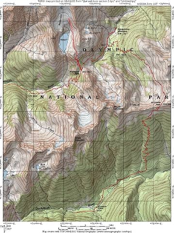 Section 3 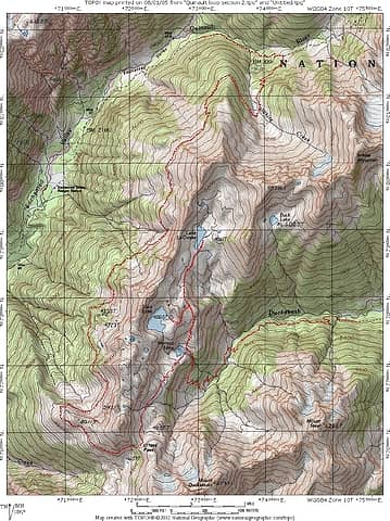 Section 2
|
| Back to top |
|
|
|
|
You cannot post new topics in this forum
You cannot reply to topics in this forum
You cannot edit your posts in this forum
You cannot delete your posts in this forum
You cannot vote in polls in this forum
|
Disclosure: As an Amazon Associate NWHikers.net earns from qualifying purchases when you use our link(s). |


