Forum Index > Trip Reports > Silver Falls State Park Loop, OR
 Reply to topic
Previous :: Next Topic
Author Message
summithound
Climbing Connoisseur


Joined: 26 Jul 2004
Posts: 1766 | TRs | Pics
Location: Everett, WA
summithound
Climbing Connoisseur
PostThu Mar 23, 2006 5:03 pm 
Monday, March 20, 2006 
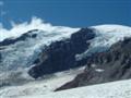
This 7.3 mile loop in Silver Falls State Park, Oregon’s largest park, is one of the state’s main attractions. The trail through the north section of this 8,706 acre park brings the hiker past 11 majestic waterfalls ranging in height from 27 to 178 feet. The loop actually consists of two separate trails, the Canyon Trail and the Rim Trail best hiked clockwise from the parking area near the South Falls Lodge. There is a three dollar entrance fee for day use visitors; however, we were able to walk to the parking area from our cabin in the central park area. Just past the Lodge, turn left onto the paved, wheelchair accessible, Canyon Trail. A short paved detour branching off to the left brings you to the top of South Falls, 177 ft. high. Return to the main trail as the pavement ends and drop down into Silver Creek Canyon. A short spur trail near the first switch-back leads 50 yards to small Frenchie Falls. Return to the main trail after viewing this waterfall and stay right as the path loops behind South Falls at 0.2 mile.
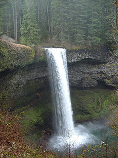
South Falls, one of the wonders along the South Fork of Silver Creek, is 177 ft. high
I had to don a gore-tex shell here to keep dry from the frothy spray of the falls. From here, the trail will parallel the South Fork of Silver Creek before climbing and then switch-backing down the hillside on a crafty set of stairs, arriving at Lower South Falls, 93 ft., at the 1.0 mile mark.
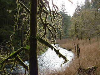
Between South Falls and Lower South Falls
The path again loops behind the falls and climbs the opposite hillside to a signed trail junction with the Maple Ridge Trail at 1.3 miles. Stay left downhill with the Canyon Trail and hike to a footbridge across the North Fork of Silver Creek. At 2.3 miles you will pass Lower North Falls at 30 ft.
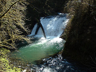
Lower North Falls along the North Fork of Silver Creek is 30 ft. high
Continue with the Canyon Trail and turn left at a spur trail just before a bridge crossing Hullt Creek.This 0.1 mile detour will lead you to the largest falls in the park, Double Falls at 178 ft. Return to the main trail and turn left, crossing the footbridge before arriving at Drake Falls, 27 ft., at 2.5 miles. An observation platform provides a prime viewpoint of the falls. At 2.7 miles Middle North Falls at 106 ft. comes into view. A spur trail to the right brings you closer to the falls, however, the portion of this trial passing behind the falls is closed.
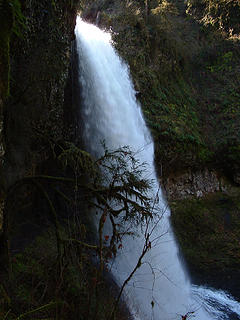
Middle North Falls is 106 ft. high
At 2.9 miles, stay left with the Canyon Trail at a junction with the Winter Trail. The Winter Trail leads 0.5 mile up to Highway 214 and the Rim Trail. The Canyon Trail will continue another 0.3 mile to Twin Falls, 31 ft. high, at 3.2 miles. Hike nearly another mile along the North Fork of Silver Creek before arriving at North Falls, 136 ft., at 4.1 miles.
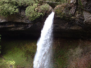
North Falls, one of most dramatic falls in the park is 136 ft. high
The trail loops behind this waterfall through a massive basalt cavern and climbs up to a parking area at 4.4 miles. Take the detour underneath the highway bridge another 0.2 mile to Upper North Falls with a height of 65 ft. at 4.6 miles.
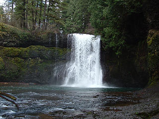
Upper North Falls, one of the more overlooked falls in the park is 65 ft. high
Return via this same trail to the junction with the Rim Trial at 4.8 miles. Stay left with the Rim trial as it parallels the highway 0.9 mile to the Winter Trail junction at 5.7 miles. For a view of Winter Falls, turn right, downhill on this trail, as it switch-backs close to the falls. Once back on the Rim Trail, travel another 1.6 miles as it borders the highway and crisscrosses the Bike Trail back to the Lodge at 7.3 miles. The weather held for the entire hike and remained mostly cloudy to complete overcast. I was able to complete the hike wearing gore-tex pants and a cotton t-shirt with the occasional application of a cotton sweatshirt and a gore-tex shell. The trail conditions were exceptional ranging from pavement to packed dirt and gravel. If anybody has any questions, feel free to ask.

Pain is just weakness leaving the body.
Back to top Reply to topic Reply with quote Send private message
Tazz
Member
Member


Joined: 27 Apr 2005
Posts: 7902 | TRs | Pics
Tazz
Member
PostThu Mar 23, 2006 5:10 pm 
Great little hike huh? Beautiful falls. A lot more water in them when I was there last. nice shots!

Back to top Reply to topic Reply with quote Send private message
summithound
Climbing Connoisseur


Joined: 26 Jul 2004
Posts: 1766 | TRs | Pics
Location: Everett, WA
summithound
Climbing Connoisseur
PostThu Mar 23, 2006 5:16 pm 
Definitely. up.gif

Pain is just weakness leaving the body.
Back to top Reply to topic Reply with quote Send private message
   All times are GMT - 8 Hours
 Reply to topic
Forum Index > Trip Reports > Silver Falls State Park Loop, OR
  Happy Birthday C Dog, carlb328, mehitabel!
Jump to:   
Search this topic:

You cannot post new topics in this forum
You cannot reply to topics in this forum
You cannot edit your posts in this forum
You cannot delete your posts in this forum
You cannot vote in polls in this forum