| Previous :: Next Topic |
| Author |
Message |
TrailPair
Member


Joined: 17 Apr 2005
Posts: 1699 | TRs | Pics
|
By sunday morning Super K and I were still undecided on where we would go for a hike/snowshoe. We only knew that due to the weather conditons, we didn't want to drive too far. So, we knew we would most likely be in the Snoqualmie Pass area....Kechelus Ridge? Pratt Mountain? Ollalie Lake? Snoqualmie Peak? We drove east on I-90 and over the pass. The weather was nasty.....33 degrees and sleeting. So, we turned back. Now driving west we turned off at the Denny creek Exit. We thought we might check out the road conditions for Road 5510...just to see how far up we could drive. We were surprised to find we could drive all the way to the gate. As long as we were here, we decided to make an attempt on Humpback. (We tried this mountain on January 22 with Jim K and Suzanne. But due to deep soft snow we ran out of time before we could reach the top - the Seahawks were playing that afternoon!)
We left the Jeep near the gate (elev. 2,000 ft +/-) and headed up the snow covered road with the snowshoes strapped onto our packs. We hiked under the R.R. tressel and to the first switchback. It wasn't far....maybe 1/2 mile....but already the snow was soft enought to justify putting the snowhsoes on. As we continued on, K would lightly float over the snow. While I would step on the crust and it would break under my weight. It caused me to work harder and K was getting farther ahead. But I trudged on.
At about 2 miles from the TH, at a wide sweeping right hand turn, we spotted the pink ribbons on the uphill side of the road that marked the route that would lead up to the ridge above. The last time we were here, the deep snow had covered the ribbons. Anyway, we started up the slope into the dense brush. The occasional ribbbons and the branches lopped from the trees made the route easy enough to follow.......But it was miserable. The snow laden branches would drop their load on us as we tried to "swim" through. I kept getting the tail end of my ice axe tangled in the branches and I would have to drop to my knees ( cussing and swearing at the futility of the situation) and crawl to get through to the next tangle of brush. After about an hour and 800 ft. of vertical gain we finaly broke through the dense brush into the more open old growth forest. Here, we stopped for a change of clothes (we were soaked) and for some food. A back country skier passed us, I know he was having a difficult time getting his skies through the brush too.
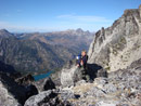
With a dry shirt on and refueled, we started up again. Now the 'shoeing was much easier. the slope had eased as we weaved our way through the open forest. The ridge narrowed. On a decent day there would be nice views along the ridge line....but now views today! We caught up with the skier about 100 ft. below the summit. He was pulling the skins off his skies and preparing for his fast descent. His plan was to head due west going down the open slopes until he intersected the road. This could make a good ascent route on the winter when the snow conditions are good and avy danger is low. We turned back up the ridge line. Approaching the summit, the slope gets very steep. We dropped our packs, took off our snowshoes, grabbed our ice axes andd self belayed the last 70 ft. to the summit. At the top, we took some photos, even though there wsn't much difference between the color of the sky and the color of the open summit. It took us 4 hours to reach the top from the TH. Now it was time to descend. We decided to retrace our tracks back down the ridge, through the forest and thrashing our way through the brush to the road. Why would we go back through the brush when we had seen the skier head down the open slopes? Good question.....But since we have had some bad experiences with "alternate routes" We decided it was better to go back the route we knew rather than going down a different unknow route and finding some nasty surprises.
All in all, a successful outing.....even without the views.
Time to summit: 4 hours
Time to TH: 2 1/4 hours
Distance: 8 miles
Elevation gain 3300 ft.
This thing called work is interfering with my play
This thing called work is interfering with my play
|
| Back to top |
  
|
|
JimK
Member

Joined: 07 Feb 2002
Posts: 5606 | TRs | Pics
Location: Ballard |
|
JimK
Member
|
 Mon Mar 27, 2006 3:17 pm |
|
|
I'm glad to hear that at least some of us made it to the summit this year. Now you just need to return on a clear day. So those pink ribbons are easy to see. Hmm...
|
| Back to top |
|
|
Kat
Turtle Hiker
Joined: 05 Oct 2003
Posts: 2560 | TRs | Pics
|
|
Kat
Turtle Hiker
|
Mon Mar 27, 2006 6:56 pm |
|
|
The current snow pack is huge, isn't it? I had thoughts of Humpback on Sunday, but settled for Annette below. Never needed the snowshoes contrary to the WTA report from Friday  In fact, the packed down path was so narrow I can't imagine safely negotiating that with snowshoes. And have to further admit, once we got up there (pretty late) - we bailed on further trekking and went home to a bbq T-Bone dinner In fact, the packed down path was so narrow I can't imagine safely negotiating that with snowshoes. And have to further admit, once we got up there (pretty late) - we bailed on further trekking and went home to a bbq T-Bone dinner  Thanks for the TR! We've got to get more motivated!
|
| Back to top |
|
|
Allison
Feckless Swooner

Joined: 17 Dec 2001
Posts: 12287 | TRs | Pics
Location: putting on my Nikes before the comet comes |
|
Allison
Feckless Swooner
|
Mon Mar 27, 2006 7:12 pm |
|
|
Hunpack? 
www.allisonoutside.com
follow me on Twitter! @AllisonLWoods
www.allisonoutside.com
follow me on Twitter! @AllisonLWoods
|
| Back to top |
|
|
Kat
Turtle Hiker
Joined: 05 Oct 2003
Posts: 2560 | TRs | Pics
|
|
Kat
Turtle Hiker
|
Mon Mar 27, 2006 7:16 pm |
|
|
|
| Back to top |
|
|
Allison
Feckless Swooner
Joined: 17 Dec 2001
Posts: 12287 | TRs | Pics
Location: putting on my Nikes before the comet comes |
|
Allison
Feckless Swooner
|
Mon Mar 27, 2006 7:38 pm |
|
|
Alternate spelling, or is the Internet really screwing with the lexicon? 
www.allisonoutside.com
follow me on Twitter! @AllisonLWoods
www.allisonoutside.com
follow me on Twitter! @AllisonLWoods
|
| Back to top |
|
|
TrailPair
Member
Joined: 17 Apr 2005
Posts: 1699 | TRs | Pics
|
Yea, it is in fact Humpback.  Somtimes my fingers and the key board don't cooperated very well. Somtimes my fingers and the key board don't cooperated very well. 
This thing called work is interfering with my play
This thing called work is interfering with my play
|
| Back to top |
|
|
Dayhike Mike
Bad MFKer
Joined: 02 Mar 2003
Posts: 10955 | TRs | Pics
Location: Going to Tukwila |
"There is only one basic human right, the right to do as you damn well please. And with it comes the only basic human duty, the duty to take the consequences." -P.J. O'Rourke
"Ignorance is natural. Stupidity takes commitment." -Solomon Short
|
| Back to top |
|
|
TrailPair
Member
Joined: 17 Apr 2005
Posts: 1699 | TRs | Pics
|
Yea, I could correct it....but then I would get less responses from the grammar whiz kids 
This thing called work is interfering with my play
This thing called work is interfering with my play
|
| Back to top |
|
|
Slugman
Its a Slugfest!

Joined: 27 Mar 2003
Posts: 16874 | TRs | Pics
|
|
Slugman
Its a Slugfest!
|
Wed Mar 29, 2006 12:38 am |
|
|
Here's a challenge: try to pronounce "hunpback" exactly the way you would "humpback" except for the "n" instead of the "m". It's impossible!
|
| Back to top |
|
|
|
|


 But, the thought of a good lookin' Hun hefting a Pack could be interesting too
