| Previous :: Next Topic |
| Author |
Message |
satyrium1975
Member


Joined: 15 Feb 2006
Posts: 61 | TRs | Pics
Location: Seattle area |
I just got back from an aborted attempt to hike Otter Falls. I used Harvey Mannings guidebook to direct me there and was thwarted in my efforts. Granted, I admit I'm directionally impaired, but he has the hiker refer back to two other hikes for portions of the directions. I had no idea what part of the previous hikes directions to use and ended up totally confused. I drove for hours and I think I was probably right there, but due to not knowing precisely what to look for, I didn't make the hike.
Is it just me, or has anyone else found that when they turn to Harvey Manning, of Mountaineers guidebook fame, for directions that they end up sitting at a coffee shop a few hours later, talking about the one that got away? This is about the tenth time I've had this experience.
I'd love to hear input from other hikers. If Harvey doesn't do it for you either, who do you recommend?
Thanks!! You'll save me a lot of hours in coffee shops crying in my lattes.
|
| Back to top |
  
|
|
Malachai Constant
Member

Joined: 13 Jan 2002
Posts: 16100 | TRs | Pics
Location: Back Again Like A Bad Penny |
They all have flaws but that adds to the adventure! Beckey sometimes mixes up left and right, Taber and crowder must have had warp drive etc. The easiest way to find otter falls is to use a GPS as there is a geocache there. It is up Taylor river just past a creek crossing and a campsite often there is a cairn  at the junction. at the junction.
"You do not laugh when you look at the mountains, or when you look at the sea." Lafcadio Hearn
"You do not laugh when you look at the mountains, or when you look at the sea." Lafcadio Hearn
|
| Back to top |
|
|
peppersteak'n'ale
Member
Joined: 28 Aug 2003
Posts: 1996 | TRs | Pics
|
When I was there we took the Lake Dorothy Road to FS 56, followed it till you couldn't go any more (parking area there) and walked gated FR 5630 (Taylor River Road?) about 4 miles till you cross a huge, partially washed out culvert. Walked a couple hundred yards, turned left into the woods, walked 150 yards or so and came to Otter falls.
|
| Back to top |
|
|
Dayhike Mike
Bad MFKer
Joined: 02 Mar 2003
Posts: 10955 | TRs | Pics
Location: Going to Tukwila |
Maps are helpful.  Buy one and use it next time in conjunction with the guide books. No written guide can give you the same wealth of information that can be conveyed with a simple hi-res topo map.
You may have a hard time reading them now, but that'll never improve unless you start somewhere. It doesn't take much effort to get the hang of it.
A couple years of it and you'll be ready to shed the bonds of the beaten path.
Buy one and use it next time in conjunction with the guide books. No written guide can give you the same wealth of information that can be conveyed with a simple hi-res topo map.
You may have a hard time reading them now, but that'll never improve unless you start somewhere. It doesn't take much effort to get the hang of it.
A couple years of it and you'll be ready to shed the bonds of the beaten path.
"There is only one basic human right, the right to do as you damn well please. And with it comes the only basic human duty, the duty to take the consequences." -P.J. O'Rourke
"Ignorance is natural. Stupidity takes commitment." -Solomon Short
"There is only one basic human right, the right to do as you damn well please. And with it comes the only basic human duty, the duty to take the consequences." -P.J. O'Rourke
"Ignorance is natural. Stupidity takes commitment." -Solomon Short
|
| Back to top |
|
|
whitebark
Member

Joined: 08 Jul 2005
Posts: 1864 | TRs | Pics
Location: Seattle |
With all this info, it otter be easy to find the falls! 
|
| Back to top |
|
|
captain jack
Serving suggestion

Joined: 25 May 2004
Posts: 3389 | TRs | Pics
Location: Upper Fidalgo |
I would tell you where it is, but my Lipsy sealed. 
|
| Back to top |
|
|
wildernessed
viewbagger

Joined: 31 Oct 2004
Posts: 9275 | TRs | Pics
Location: Wenatchee |
I haven't had a problem overall with his or other guidebooks, it seems to me you need multiple sources corraborated with a map (Washington Gazetter, Washington Road and Recreation Atlas for getting there) and GTM (which have errors). I like the 1:24000 USGS maps the best, small scale gives the big picture, but many of those need updated also and aren't as readily available as the GTM around here. My conclusion is and I generally try to cross reference my information among as many sources as I have.
P.S. If you have mapping software you can often query the software with a name of a waterfalls, lake, peak and it will give you a list of similairly named locations and you can pick which one you want, not knowing exactly where it is.
Living in the Anthropocene
Living in the Anthropocene
|
| Back to top |
|
|
touron
Member
Joined: 15 Sep 2003
Posts: 10293 | TRs | Pics
Location: Plymouth Rock |
|
touron
Member
|
 Sat May 13, 2006 11:21 am |
|
|
| Quote: | | Is it just me, or has anyone else found that when they turn to Harvey Manning, of Mountaineers guidebook fame, for directions that they end up sitting at a coffee shop a few hours later, talking about the one that got away? This is about the tenth time I've had this experience. |
 They say coffee is good for you and loaded with anti-oxidants, so ending up at the latte stand may not be all bad.
When I went there, I parked at the gated bridge, walked up the road a few miles (4?), and turned left at the cairn (which may not be there), proceeded up a crummy short trail to the lake, which is really more of a pond. There were other people walking the road that day which made finding the falls easier, though tourons aren't always the most reliable source of information. This would probably be a good time of year to see the falls, or scarf a latte. Now if you run into Harvey Manning at a latte stand, that would be really bad news.
They say coffee is good for you and loaded with anti-oxidants, so ending up at the latte stand may not be all bad.
When I went there, I parked at the gated bridge, walked up the road a few miles (4?), and turned left at the cairn (which may not be there), proceeded up a crummy short trail to the lake, which is really more of a pond. There were other people walking the road that day which made finding the falls easier, though tourons aren't always the most reliable source of information. This would probably be a good time of year to see the falls, or scarf a latte. Now if you run into Harvey Manning at a latte stand, that would be really bad news. 
Touron is a nougat of Arabic origin made with almonds and honey or sugar, without which it would just not be Christmas in Spain.
Touron is a nougat of Arabic origin made with almonds and honey or sugar, without which it would just not be Christmas in Spain.
|
| Back to top |
|
|
Dayhike Mike
Bad MFKer

Joined: 02 Mar 2003
Posts: 10955 | TRs | Pics
Location: Going to Tukwila |
Tell you what.
I have a copy of Topo! with coverage of seattle, Mount Rainier, and the Central Cascades.
Not the entire state, mind you, but it's a start and better than nothing.
I'll bring it to the next social. Show up there and buy me a beer and you can take it home with you. 
"There is only one basic human right, the right to do as you damn well please. And with it comes the only basic human duty, the duty to take the consequences." -P.J. O'Rourke
"Ignorance is natural. Stupidity takes commitment." -Solomon Short
"There is only one basic human right, the right to do as you damn well please. And with it comes the only basic human duty, the duty to take the consequences." -P.J. O'Rourke
"Ignorance is natural. Stupidity takes commitment." -Solomon Short
|
| Back to top |
|
|
touron
Member
Joined: 15 Sep 2003
Posts: 10293 | TRs | Pics
Location: Plymouth Rock |
|
touron
Member
|
Sat May 13, 2006 1:56 pm |
|
|
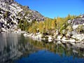
Randy's birdseye shot of Lipsy Lake.
Touron is a nougat of Arabic origin made with almonds and honey or sugar, without which it would just not be Christmas in Spain.
Touron is a nougat of Arabic origin made with almonds and honey or sugar, without which it would just not be Christmas in Spain.
|
| Back to top |
|
|
Criminal
Member

Joined: 25 Mar 2004
Posts: 869 | TRs | Pics
Location: Cloud hidden, whereabouts unknown. |
|
Criminal
Member
|
Sat May 13, 2006 4:04 pm |
|
|
Map or GPS, this is the turn-off point along the trail: N47 35.140 W121 28.063
Because I am mad about women, I am mad about the hills
Said that wild old wicked man, who travels where God wills. - Yeats
topohiker.com
Because I am mad about women, I am mad about the hills
Said that wild old wicked man, who travels where God wills. - Yeats
topohiker.com
|
| Back to top |
|
|
Karen
Member

Joined: 22 Dec 2001
Posts: 2866 | TRs | Pics
|
|
Karen
Member
|
Sat May 13, 2006 6:14 pm |
|
|
Harvey Manning is a good writer, one of the best. But if you are new to hiking you have to realize that Harvey hasn't hiked some of the trails he's written about in the hiking guides for a while. Some of these trail descriptions are out of date -- sometimes by several years. Mountaineer Books keeps putting out new editions of his (and other) hike guides and make an attempt to keep up to date with changes but it's hard to keep up with all the changes. Road numbers change, old roads become trails, trail numbers change .... old trails disappear, new trails are put in. What was true 4-5 years ago in terms of getting to a place might not be what you come across today. I admire Manning and his trail descriptions but I always bear in mind that some of them are out of date, especially when it comes to driving directions.
Having a GPS is great for those who can afford them and have the desire (and ability) to figure out how to use them. As for me, I use a combination of trail descriptions (including Manning's), check the trail reports on the websites (WTA and this site) and utilize a map of the region. The maps change too, BTW. For road conditions, I sometimes call the appropriate Ranger Station the day before I head out because their reports are sometimes out of date, especially this time of year.
Odd this topic would come up today because friends and I were scouting a trail on Tiger Mountain today for a loop and two of us had the 1999 map (the big one) and another had the 2002 version and there is a world of difference between those two maps. For example, Manning's Reach, isn't even in the same place on these maps!!
Karen
stay together, learn the flowers, go light - from Turtle Island, Gary Snyder
stay together, learn the flowers, go light - from Turtle Island, Gary Snyder
|
| Back to top |
|
|
1k
Member

Joined: 29 Jun 2004
Posts: 606 | TRs | Pics
Location: Ballard |
|
1k
Member
|
Sat May 13, 2006 6:44 pm |
|
|
Was just up that way Wednesday on the route to Snoqualmie Lake.
After setting out from the Taylor River Road gate, the first landmark is the Martin Creek bridge, about 3 miles. Shortly past that the trail/road goes past a 6' culert visible to the right. At that point you are really close. Just a bit farther is a small campsite and fire pit on the left. From there is is just a matter of a few yards to the bootpath up to the falls. There was a small carin there the other day. Head up bearing left and you will be there is a few minutes.
Life is short, hike hard...
Life is short, hike hard...
|
| Back to top |
|
|
whitebark
Member

Joined: 08 Jul 2005
Posts: 1864 | TRs | Pics
Location: Seattle |
And if you reach the Big Creek bridge (the heavy-duty concrete one), you've gone about a half mile too far. Backtrack to get to Otter Falls.
Big Creek also has a nice waterfall--worth going beyond Otter Falls to see.
|
| Back to top |
|
|
satyrium1975
Member
Joined: 15 Feb 2006
Posts: 61 | TRs | Pics
Location: Seattle area |
|
satyrium1975
Member
|
Sat May 13, 2006 10:47 pm Harvey Manning plus GPS, Topo, Gazateer, and three websites!
|
|
|
Wow, I'm impressed and pleased with all the feedback about my complaint with getting lost when I have a Manning guidebook in hand. Thanks for all the great tips! (And humor! )
I'm getting the impression overall that gone are the days of setting off with your pack, the essentials, and your guidebook and making the desired hike. It sounds like, these days, with all the trails changing and names changing, maps being outdated, in order to actually arrive at more than 1 out of 3 trailheads, I'm going to need to go high tech. Rats. It's ironic that I need to go to technology to get away from it.
I give up the no-tech approach. So next I guess the question would be, what GPS unit do I get that manages to be effective and affordable?
|
| Back to top |
|
|
|
|
You cannot post new topics in this forum
You cannot reply to topics in this forum
You cannot edit your posts in this forum
You cannot delete your posts in this forum
You cannot vote in polls in this forum
|
Disclosure: As an Amazon Associate NWHikers.net earns from qualifying purchases when you use our link(s). |


