| Previous :: Next Topic |
| Author |
Message |
naturealbeing
Member


Joined: 05 Dec 2004
Posts: 1565 | TRs | Pics
Location: Great Mystery |
Last year on the 21st of October Jeff and I made an attempt on Malachite Peak coming from the Malachite Lake side and wound up heading to far NW. In order to get something out of our efforts and time constraints we summited Turquoise Peak.
Fast forward: After careful review of Randy Bs and Mike Collins report along with pictures that Ive shot of Malachite we were on a no fail mission.
On the night before the trip, the plan was to go back in from the Malachite Lake side, but after sleeping on it and thinking, did I want to start at 3600 or 1600. Starting at 3600 would mean some ups and down, but by going out on the Malachite Lake side and out the West Fork Foss Trail (1064) we would escape the ups and downs and not have to deal with the 90+ degree weather once we were back into the trees near the Malachite Lake outlet.
That became the plan and we left Jeffs truck at the WFF TH 1064 and drove my car to just pass the Evans Lake TH and hit the fishermans trail to Rock Lake. Because of the predictions of 90+degree weather on this day we decided to travel as light as possible, no ice axes and trail runners on the feet.
As we entered the bush we couldnt help but notice the how muggy it was, this was going to be a constant thyme all day w/the exceptions of a few cool breezes that would come our way every now and then. Up the ridge and down to Rock Lake and then passing the lake on the E and up to the ridge that separates Rock Lake and Panorama Lake. During this section we took plenty of mini breaks from the sun and refueled and quenched our thirsts to keep from drying up. The sun was just brutal and had us moving like slugs.
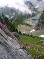
Rock Lake was as beautiful as ever with its deep blue color and Panorama Lake was still covered in snow with partial pools of azure colored water showing.
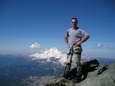
From the ridge we had to lose some elevation and traverse over talus to the N ridge of Malachite Peak. Once here we dropped down on the W slope on a goat trail and continued on to the gap via goat trail, more talus and large patches of snow. It think this was the first time I ever kicked and cut in steps with trail runners on. I felt fortunate that the snow was just soft enough to allow me to do so. We took a nice break at the gap and I took some shots of Purvis Lake below, it had the same color as Rock and looked pretty inviting, considering the heat. Dropping down the S side of the gap was a bit tricky as it was mostly covered with loose scree and was like walking on marbles on a church steeple. Once we reached the low point and started to take in the cork screw grand tour (as Randy mentioned) we keep looking for a route up to our left, not seeing what we were looking for we wound up at a gap on the S ridge that in order to continue we would have had to drop to the E slope and this was not in any of the reports that we read. We sat down, reviewed our maps, reports and consumed more fuel. Then we reversed our route and went through some scrub cedar and just pass on the other side was a faint trail that lead up to a rock wall. It didnt look obvious that a person could go any further, but upon inspection I found what Randy describes as some scrub cedars that did not want him to pass. This was right of the rock wall and as I squeezed myself through the going became easier on the other side. From here we were able to continue on, goat trails, scree, and some class 3 rock scrambling (w/some minor exposure) to get onto the S ridge crest. Finally the summit came into view and again we packed down more food and took a break in the shade. The final push was more of what we just went through and in 10 minutes we were on top.
All the familiar names from NWHs were listed in the register and even tho it was damp we were able to squeegee are names in with the pencil left. Took some pics and then headed out.
Our intended route was to head down towards Malachite Lake, but try and find a more direct route to the bridge if possible. We wound up crossing the out let after a bit of some brush bashing and catching up to the trail about 2-3 switchback before the bridge. From here it was smooth sailing back to the WFF TH 1064.
I know that malachite peak has been done from many different starting points, with loops and point-to-point trips, but I must say that I feel really gratified in doing this trip using this route. We were able to start high and quickly get into some alpine lakes with some of the most interesting rock gardens on route and capture some really pretty eye candy before our trail slog out. Also, traveling with Jeff is always a fun time our sense of humor had us laughing most all day long and thats always a great gift to share with anyone. Thanks! Jeff, for your friendship and sharing your passion of the mountains with me one more time.
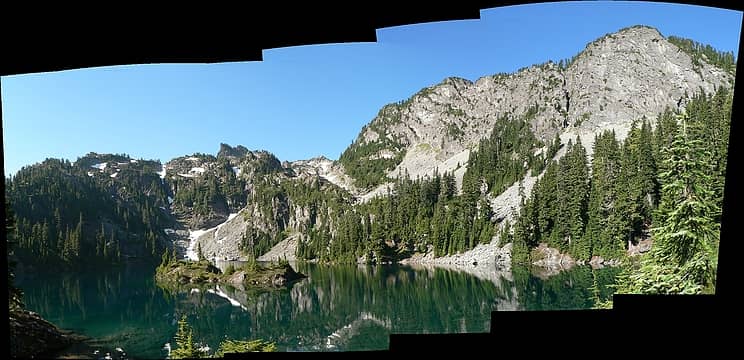 Rock Lake Panorama as seen from the NE side 7.23.06. 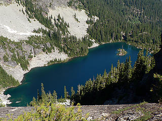 Rock Lake as seen from ridge heading up to Panorama Lake 7.23.06. 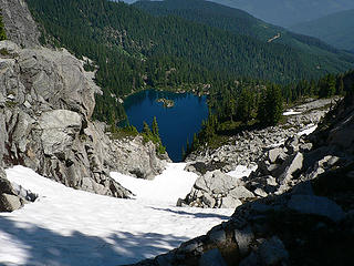 Rock Lake as seen from ridge heading up to Panorama Lake 7.23.06. 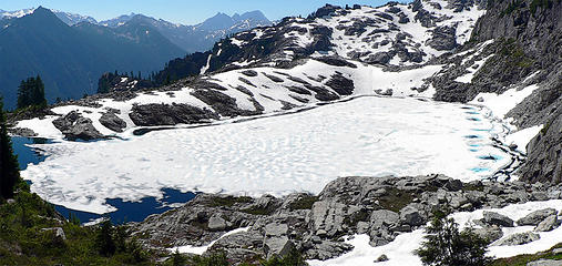 Panorama Lake as seen while ascending talus field to Malachites N ridge 7.23.06. 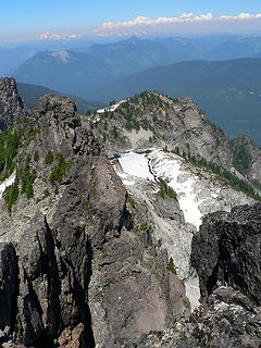 Panorama Lk.from Malachite Pk. 7.23.06. 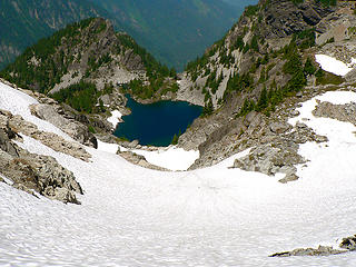 Purvis Lake as seen from the gap W of Malachites summit 7.23.06. 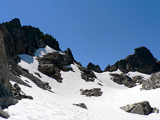 Approaching the gap from the W slope 7.23.06. 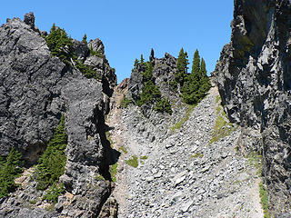 Looking back at the gap from the S side 7.23.06. 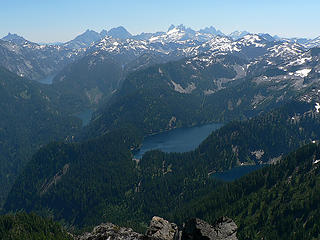 Alpine Lakes as seen from near the summit of Malachite Peak 7.23.06. 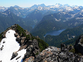 6 Lake View SSE of Malachite Pk. 7.23.06. 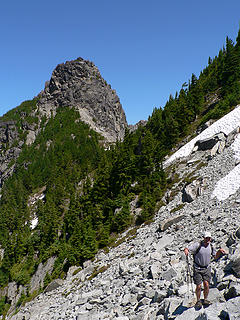 Jeff on the rocks traversing the W slope on talus 7.23.06. 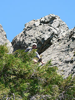 Jeff attempts to jump through some cedar scrubs 7.23.06. 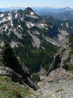 Turquoise Peak as seen from the W slopes of Malachite Peak 7.23.06.
|
| Back to top |
  
|
|
Backpacker Joe
Blind Hiker

Joined: 16 Dec 2001
Posts: 23956 | TRs | Pics
Location: Cle Elum |
Great pics NB.
"If destruction be our lot we must ourselves be its author and finisher. As a nation of freemen we must live through all time or die by suicide."
Abraham Lincoln
"If destruction be our lot we must ourselves be its author and finisher. As a nation of freemen we must live through all time or die by suicide."
Abraham Lincoln
|
| Back to top |
|
|
Randy
Cube Rat

Joined: 18 Dec 2001
Posts: 2910 | TRs | Pics
Location: Near the Siamangs |
|
Randy
Cube Rat
|
 Fri Aug 04, 2006 1:53 pm |
|
|
Excellent! The route not only starts high, but I love the lake scenery along the way. Great work, hopefully my report wasn't too confusing.
|
| Back to top |
|
|
Tom
Admin
Joined: 15 Dec 2001
Posts: 17857 | TRs | Pics
|
|
Tom
Admin
|
Fri Aug 04, 2006 2:11 pm |
|
|
You guys are heading up too quick to the summit. Peakbaggers.  From the scree, shoot for the semi grassy area just above the west pass. From there it's a relatively easy scramble to the summit. From the scree, shoot for the semi grassy area just above the west pass. From there it's a relatively easy scramble to the summit.
|
| Back to top |
|
|
Jeff R
Closet hiker.
Joined: 10 Apr 2005
Posts: 972 | TRs | Pics
Location: Everret |
|
Jeff R
Closet hiker.
|
Fri Aug 04, 2006 3:40 pm |
|
|
Great report and pictures naturealbeing! I am glad you recommended the one way trip.
Tom- We looked down on that option from the top and wished we had explored around more instead of the circle tour we did. The summit is just right above that notch.
|
| Back to top |
|
|
wildernessed
viewbagger

Joined: 31 Oct 2004
Posts: 9275 | TRs | Pics
Location: Wenatchee |
Living in the Anthropocene
|
| Back to top |
|
|
Jeff R
Closet hiker.
Joined: 10 Apr 2005
Posts: 972 | TRs | Pics
Location: Everret |
|
Jeff R
Closet hiker.
|
Fri Aug 04, 2006 3:52 pm |
|
|
| wildernessed wrote: | | instead of the plunge stepping down slopes, and sometimes a trail, say wow, look at that rock and next thing you know your clinging to class 4 rock and saying, why am I following these rock monkeys ? |
The Grindstone trip with Tazz, myself, and you sounds like it fits that urge you describe.
|
| Back to top |
|
|
wildernessed
viewbagger
Joined: 31 Oct 2004
Posts: 9275 | TRs | Pics
Location: Wenatchee |
Living in the Anthropocene
|
| Back to top |
|
|
Tazz
Member

Joined: 27 Apr 2005
Posts: 7902 | TRs | Pics
|
|
Tazz
Member
|
Fri Aug 04, 2006 3:58 pm |
|
|
|
| Back to top |
|
|
wildernessed
viewbagger
Joined: 31 Oct 2004
Posts: 9275 | TRs | Pics
Location: Wenatchee |
As were climbing up exposed and nearly vertical, NEXT to the ridge you can walk up....
"There's no going back this way"_JeffR 
Living in the Anthropocene
Living in the Anthropocene
|
| Back to top |
|
|
naturealbeing
Member
Joined: 05 Dec 2004
Posts: 1565 | TRs | Pics
Location: Great Mystery |
BJ, thanks for the compliment.
Randy, I agree on the scenery, and no, your report was a ok. As you know from your trip that whole summit is a jumbled blocky rockiness of mountain madness and hard to get an exact bead as to where the true high point is until you are on the ridge crest. Even from both approaches its difficult to define the high point.
Tom, Once on top it makes good sense as to what you were saying about heading to the summit from the gap, but its not that apparent where the summit is from the gap.
Jeff R. I'm glad your glad we went with the point-point route and thanks for the kind words.
wilderness, Glad to see you enjoyed the TR and pics.
|
| Back to top |
|
|
Edd
Member

Joined: 23 Jun 2003
Posts: 296 | TRs | Pics
|
|
Edd
Member
|
Fri Aug 04, 2006 5:22 pm |
|
|
| naturealbeing wrote: | | Dropping down the S side of the gap was a bit tricky as it was mostly covered with loose scree and was like waking on marbles on a church steeple. |
Your not kidding, Congatulations 
|
| Back to top |
|
|
|
|


 Nice TR and pics as usual.
