| Previous :: Next Topic |
| Author |
Message |
ragman and rodman
Member


Joined: 28 Apr 2005
Posts: 1219 | TRs | Pics
Location: http://rgervin.com/ |
Oh baby
was it ever cold today
21 degrees as rodman and I drove over Snoqualmie Pass at 7:00 a.m. on our way for another Teanaway fix
and it was just as cold at 8:00 a.m. when we parked at the Beverly Turnpike trailhead (3600).
One half mile up the trail we turned right on the Bean Creek Trail (#1391.1) and continued another 1.5 miles where the Bean Creek Trail crosses the creek and continues towards a saddle that provides access to Earl Peak
Instead of crossing the creek we continued straight for another half mile and reached Bean Creek Basin (5500) where we finally caught up with some very welcomed sunshine.
After a short break to thaw out a bit, we headed northwest, bypassing a very cliffy section as we worked our way up to the Marys/Bean ridge
once on the ridge we had an easy quarter mile scramble to Marys summit (6730 on our GPS)
from Marys we continued south and did an easy half-mile scramble along the ridge over to the Judys Peak summit (6600 on our GPS)
from Judys we continued east for a half-mile along a gentle ridge to approximately 6300 feet
then we started a fairly steep descent to the south where we rejoined the Bean Creek Trail
leaving a 1.5 mile walk back to the car.
Excellent close-in views of the Stuart Range and the Teanaway Mountains
nice distant views of Rainier, Adams, and Alpine Lakes Wilderness peaks stretching from Hibox and Three Queens to Hinman and Daniel.
We didnt see anyone else on this very cold day
6 miles roundtrip, gaining 3176 feet of elevation.
GPS route and pictures for Mary's Peak and Judy's Peak
..
|
| Back to top |
  
|
|
Sabahsboy
Member

Joined: 18 Jul 2006
Posts: 2484 | TRs | Pics
Location: SW Sno County |
|
Sabahsboy
Member
|
 Thu Nov 02, 2006 9:14 pm Teanaway and Wenatchee Mountains
|
|
|
Yummy photos. Thank you.
Those are sure bare mountains. I hope the wind was not whipping around. Burrrr...
Several of the shots are just wonderful. Love the "close up of Mt. Rainier". Speaking of....can you imagine how that place is today with the rain and likely snow up there? I am sure I will view these photos again!
|
| Back to top |
|
|
wildernessed
viewbagger

Joined: 31 Oct 2004
Posts: 9275 | TRs | Pics
Location: Wenatchee |
Strong work, finally hiking season has arrived ! 
Living in the Anthropocene
Living in the Anthropocene
|
| Back to top |
|
|
Slide Alder Slayer
Member

Joined: 14 Jan 2002
Posts: 1960 | TRs | Pics
|
Very nice trip report! I was on Earl 10/26 and couldnt see squat. I have always liked your GPS maps and pictures. Which GPS do you use?
|
| Back to top |
|
|
naturealbeing
Member

Joined: 05 Dec 2004
Posts: 1565 | TRs | Pics
Location: Great Mystery |
Well you guys put together another fine trip, along with great pics and TR to boot. I really like the pano between Bill Peak and Bean Peak w/the Stuart Range in the background, Sweet!.
I Love all of that weathered, rust color coating of serpentine. I find it hard to believe that underneath it is this rich jade colored stone.
Seems like we keep missing one another, Steve Fossen and I were in there the 20th of October and we did a loop from Beverly Turnpike > Bill Peak > Bean Pass > Bean Peak > Bean Creek Trail > TH.
I had hoped that we could have traveled a bit faster and gone over to Mary and Judy then take the ridge down, where the trails of Beverly Creek and Bean Creek meet. Not enough hours in a day for us.
Sense you guys where up there on Judy, do you think that the route down that I mentioned above is viable?
Just a reminder, I still want to get out with you guys on a trip, Pm me when your heading out and wouldn't mind some additional company.
PS, The above also applies to you too wildernessed.
Cheers!
Richard
|
| Back to top |
|
|
JimK
Member

Joined: 07 Feb 2002
Posts: 5606 | TRs | Pics
Location: Ballard |
|
JimK
Member
|
Fri Nov 03, 2006 12:42 pm |
|
|
Nice report again. Your route up is full of wildflowers in the early summer. I was surprised to see them far above the basin along the many creeks. That ridge over to Bean is a fun scramble most of the way but has a difficult spot near Bean Peak. Here is shot of Mary from the middle of the ridge:
Richard, I have not done the SW Ridge down to the Beverly trail but I know folks who have. It should not be that difficult.
I need to plan another winter overnighter over there.
|
| Back to top |
|
|
dicey
custom title

Joined: 11 May 2004
Posts: 2869 | TRs | Pics
Location: giving cornices a wider berth |
|
dicey
custom title
|
Fri Nov 03, 2006 12:49 pm |
|
|
| naturealbeing wrote: | | I had hoped that we could have traveled a bit faster and gone over to Mary and Judy then take the ridge down, where the trails of Beverly Creek and Bean Creek meet. Not enough hours in a day for us. |
I was thinking about a similiar loop including all 4 summits. I guess I'll wait for longer days. 
|
| Back to top |
|
|
naturealbeing
Member
Joined: 05 Dec 2004
Posts: 1565 | TRs | Pics
Location: Great Mystery |
JimK, Thanks for the verification on the route in question. Let me know if you plan to do the brothers next year, I'd love to tag along.
Well...if that's your plan dicey, I'd throw in Louvre and Volcanic Neck for good measure. That would be nearing an epic adventure, well maybe not, but at least one beautiful long day, with lots of great eye candy to delight the senses.
|
| Back to top |
|
|
ragman and rodman
Member
Joined: 28 Apr 2005
Posts: 1219 | TRs | Pics
Location: http://rgervin.com/ |
NB... about the southwest ridge from Judy's Peak down to the intersection of the Beverly/Bean trails... no idea about that route, but JimK did say it has been done... on our trip we only had to lose 1000 feet of elevation in the trees... that southwest ridge loses 1500 feet of elevation in the trees... the contour lines on the map look pretty much the same, but I've been fooled more than once by them... rodman and I are still interested in doing Mt. Ruth in MRNP... not sure about this year though.
Jim... I was on your website and read your TR about going from Mary's Peak to Bean Peak... and how you eventually had to get off of the ridge to get over to Bean... I know what you are talking about... a couple of years ago our group of 4 hiked to Mary's Peak (thinking it was Bill's Peak based on the first edition of Goldman's 75 Scrambles book... which has been corrected in her second edition of the book) and then started along the ridge for Bean Peak... eventually 3 of us said no more and got off of the ridge... the other person stayed on the ridge all the way to Bean Peak... he beat us to the summit and told us that there was some Class 5 stuff along the way... I don't know about you, but my eyes start to glaze over when Class 4 comes into play... Class 5 is beyond my imagination.
dicey... the WTA site has a report of the Earl-Bean-Mary-Judy trip you mentioned... I believe the author was "Idaho Slim" or "Idaho Jim" and he did it in 2000... looks like a good one... we did the Earl-Bean trip last year... now it's time to put the 2 trips together.
|
| Back to top |
|
|
Get Out and Go
Member

Joined: 13 Nov 2004
Posts: 2129 | TRs | Pics
Location: Leavenworth |
I enjoyed the narrative and peak-spotting of all 35 photos. I felt as if I was there. Great off-trail adventures. You got me revved to go there next year.
"These are the places you will find me hiding'...These are the places I will always go."
(Down in the Valley by The Head and The Heart)
"Sometimes you're happy. Sometimes you cry.
Half of me is ocean. Half of me is sky."
(Thanks, Tom Petty)
"These are the places you will find me hiding'...These are the places I will always go."
(Down in the Valley by The Head and The Heart)
"Sometimes you're happy. Sometimes you cry.
Half of me is ocean. Half of me is sky."
(Thanks, Tom Petty)
|
| Back to top |
|
|
RG
Member
Joined: 04 Feb 2005
Posts: 27 | TRs | Pics
Location: Sammamish, Wa |
|
RG
Member
|
Sun Nov 05, 2006 8:16 am Brothers?
|
|
|
I would also like to tag along doing the Brothers. I hear that Rodman has done them, maybe he can show us the way. RG
|
| Back to top |
|
|
JimK
Member
Joined: 07 Feb 2002
Posts: 5606 | TRs | Pics
Location: Ballard |
|
JimK
Member
|
Sun Nov 05, 2006 9:19 am |
|
|
Many have done the West Brother but few have done the East. Ironically, that's the one with a trail.
|
| Back to top |
|
|
rodman
Member
Joined: 03 May 2005
Posts: 49 | TRs | Pics
|
|
rodman
Member
|
Sun Nov 05, 2006 4:38 pm |
|
|
Slide Alder Slayer - The GPS I use is a Garmin 12XL that I bought from REI April 1997 which makes it nearly 10 years old, a real antique!
Rick (RG) - The Brothers trail that I know so well is the one in the Olympics via Lena Lake as follows:
Ragman is the one who knows about the Teanaway Three Brothers. See his and Denali girl's trip report here:
https://www.nwhikers.net/forums/viewtopic.php?t=10629&highlight=navaho
Ragman and I have hiked the Bean creek / Beverly creek trails many times, here is a merged view of hikes over 3 years:
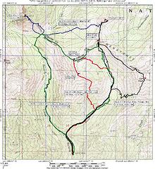 MERGED_BILLS_BEAN_MARYS_JUDYS_EARL_VOLCANIC_PEAKS
|
| Back to top |
|
|
RG
Member
Joined: 04 Feb 2005
Posts: 27 | TRs | Pics
Location: Sammamish, Wa |
|
RG
Member
|
Mon Nov 06, 2006 9:45 am Brothers
|
|
|
Rodman: Yes, those are "The Brothers" I am talking about. They seem to be calling me everytime I look to the west. It would be nice to look over the Puget Sound someday and know that I was on top of those peaks.
On another note, I am thinking of doing the Seattle Marathon at the end of November. Would you be willing to run half of it with me? RG
|
| Back to top |
|
|
|
|


