| Previous :: Next Topic |
| Author |
Message |
wildernessed
viewbagger


Joined: 31 Oct 2004
Posts: 9275 | TRs | Pics
Location: Wenatchee |
Access : SR 97, Blewitt Pass, turn off at FR9716 Swauk Creek Winter Recreation Area
Guides / Maps : Snowshoe Routes - Wa. by Nelson, GTM - Liberty or Mission Ridge / Wenatchee, Swauk Creek Recr. Brochure / Map
Stats : 5.2 mi, 2000' gain, 7 hr.
I've had Diamondhead on the brain for awhile now, and I knew Action betty had been out that way recently, so we along with Bryan planned on meeting at the parking lot at 0800 hr. There had been quite alot of new snow in the area over the last week, the weather / avalanche forecast looked improved except for cooler temps so a snowshoe using a section of the road to XC15 (Diamondhead trail) over looking Tronsen Meadows and following the E side of Diamondhead above the creek drainage to around 5500' or the saddle then turning W up to the summit was the general plan.
On the way up Blewitt I received a call from Bryan bogged down in traffic on I-90 with some heavy snows and traffic, he didn't think he would make it anytime before 0900 so decided to turn around (damn convergence zone). As I approached Blewitt there were flares on the road from an accident on the S side of the pass, and of course Denise was late and I got no cell phone coverage, she showed up about 30 min late, but in good working order, there was an apparent rollover fatality in that area though.
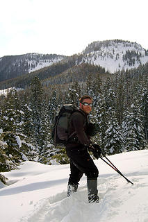
We were on snow at 0845 and Denise noted quite a bit more snow than last time and we broke our own trail the duration, no one had been out that way recently. There was a thin crust over some very fluffy snow that terrain dependent had you sinking 1-3' with snowshoes, the snow heavy and often encased trees, mountain and meadow views were awesome we were like kids in a playground.
We traversed the E lower slope of Diamondhead and at the point where you trend higher and either go up the slope or continue to the saddle and then go up the snow was just to deep and soft (waist and above), the slope in that area is probably around 45 degrees and hitting the saddle in near waist deep snow wasn't appreciated.  Not to worry we turned to the E about .25 miles from the saddle and entered the snow filled creek and immediately were hit with some ice cold winds coming from the S between the two mountains, everything that was wet or exposed burned or froze, it was 19 degrees at the TH so I know it was below zero here.The full face neoprene balacava was mandatory.
The gulley created by the creek basin clogged with snow and wind whipped features and snow pillows was knarly it sloped off maybe 30 ' down from us a long ways so we made our way across and headed SE up snow, ice, grass, and basalt talus. Denise decided to take a pass on this new mountain summit, you couldn't see it, but I approached it from the NW across some short snow gulleys and up steep mixed terrain and when I hit level ground I traversed a SE ridge to a pile of rocks which was the high point, my altimeter read a little over 6000'. The views were stunning
Not to worry we turned to the E about .25 miles from the saddle and entered the snow filled creek and immediately were hit with some ice cold winds coming from the S between the two mountains, everything that was wet or exposed burned or froze, it was 19 degrees at the TH so I know it was below zero here.The full face neoprene balacava was mandatory.
The gulley created by the creek basin clogged with snow and wind whipped features and snow pillows was knarly it sloped off maybe 30 ' down from us a long ways so we made our way across and headed SE up snow, ice, grass, and basalt talus. Denise decided to take a pass on this new mountain summit, you couldn't see it, but I approached it from the NW across some short snow gulleys and up steep mixed terrain and when I hit level ground I traversed a SE ridge to a pile of rocks which was the high point, my altimeter read a little over 6000'. The views were stunning  , that is all I can say and it was cold as hell, the coldest I have ever been out in the NW so I snapped some pics, didn't even take a break as Denise was far out of touch and headed back down. Now I always find it amusing how going up can be tedious, but when it's time to come down, it was like "holy sh##" , that is all I can say and it was cold as hell, the coldest I have ever been out in the NW so I snapped some pics, didn't even take a break as Denise was far out of touch and headed back down. Now I always find it amusing how going up can be tedious, but when it's time to come down, it was like "holy sh##"  I came up that and now I'm going to have to go back down on snowshoes no less, the MSR Lightning Ascents were worth their money over that section of mixed terrain. Back down on a secton of level talus and snow of all places I fell on my ass I came up that and now I'm going to have to go back down on snowshoes no less, the MSR Lightning Ascents were worth their money over that section of mixed terrain. Back down on a secton of level talus and snow of all places I fell on my ass  , go figure.
I ate a quick PB sandwich and we were out of there, it was a freezer.
The way back went fast but the slope sloughed off alot as we tracked by. Arriving back at the Road gave me a feeling of satisfaction and relief. Alot of deep loose snow out there that just falls away. , go figure.
I ate a quick PB sandwich and we were out of there, it was a freezer.
The way back went fast but the slope sloughed off alot as we tracked by. Arriving back at the Road gave me a feeling of satisfaction and relief. Alot of deep loose snow out there that just falls away.
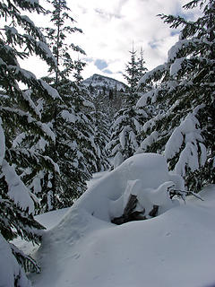 Lot's of new snow 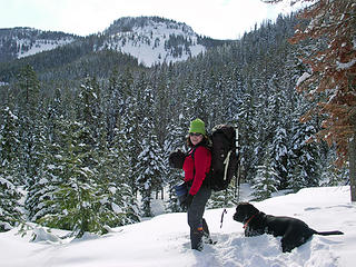 Denise and Jackson with Tronsen Meadows and Diamondhead in the background 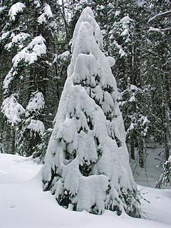 perfectly decorated tree 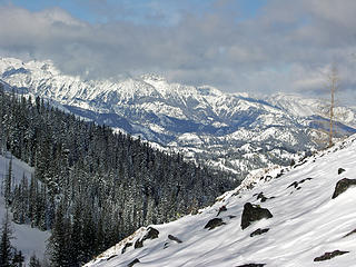 Cimbing the side of unnamed peak with the slopes of Diamondhead to the left and Teanaway / Stuart Range 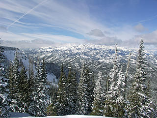 Diamondhead NE face and Teanaway / Stuart Range 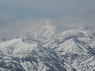 Mt. Stuart shrouded in clouds 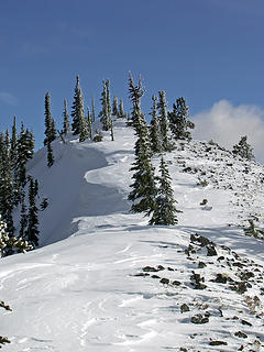 Heading up the SE ridge to the summit 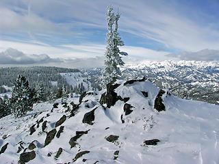 Unnamed summit with Diamondhead in the background, my altimeter read 6010' 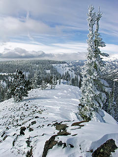 wind scoured ridge 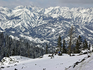 Coming down into the basin between both mountains above the creek drainage, the winds through here from the S set off snow squalls and I wore a full face neoprene balacava, it was probably well below zero with the windchill 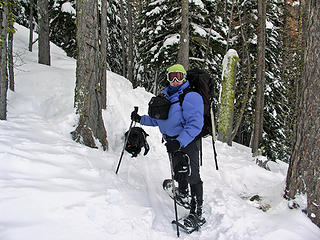 This does say COOLD ! 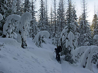 HR Puff n' Stuff area  SWEET ! 
Living in the Anthropocene
Living in the Anthropocene
|
| Back to top |
  
|
|
trailjunky
Backcountry Bumpkin'

Joined: 14 Jun 2004
Posts: 1124 | TRs | Pics
Location: timberline |
|
trailjunky
Backcountry Bumpkin'
|
 Fri Mar 02, 2007 11:39 am |
|
|
Awesome trip!  Your making me jealous. Your making me jealous.
|
| Back to top |
|
|
ActionBetty
Im a dirty hippie!

Joined: 06 Jul 2003
Posts: 4807 | TRs | Pics
Location: kennewick, wa |
|
ActionBetty
Im a dirty hippie!
|
Fri Mar 02, 2007 11:59 am |
|
|
I was happy to see Rob come back around the slopes after we separated...two ways next time fool!  It was a cold mutha out. I am gald I didnt know which peak DiamondHead really was.. no way in hell I wanted to go up that. You were asking for trouble and I didnt want any. I was happy where I made it to..Just slightly higher than when I was there a few weeks before. I had some killer views of DIamond Head and the enchantments with the tronsen meadows below.
Lots more snow this time around and definitely colder than before.
Rob, was that accident at blewett pass a fatality? I didnt watch the news or read the paper.
My back hurts today..blah
It was a cold mutha out. I am gald I didnt know which peak DiamondHead really was.. no way in hell I wanted to go up that. You were asking for trouble and I didnt want any. I was happy where I made it to..Just slightly higher than when I was there a few weeks before. I had some killer views of DIamond Head and the enchantments with the tronsen meadows below.
Lots more snow this time around and definitely colder than before.
Rob, was that accident at blewett pass a fatality? I didnt watch the news or read the paper.
My back hurts today..blah
 rob loves his new pack! 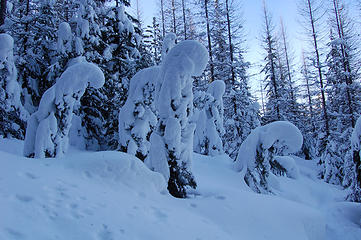 prayingforest 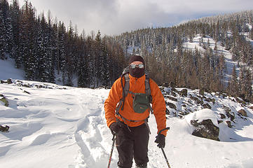 rob1 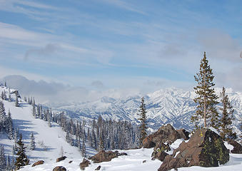 view of Diamond Head and the Enchantments 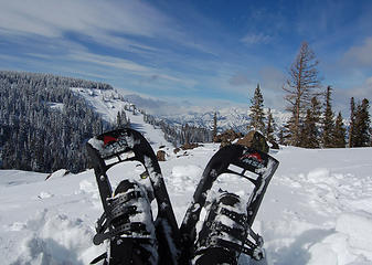 shoeshotDH 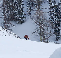 rob3
"If you're not living good, you gotta travel wide"...Bob Marley
"If you're not living good, you gotta travel wide"...Bob Marley
|
| Back to top |
|
|
wildernessed
viewbagger
Joined: 31 Oct 2004
Posts: 9275 | TRs | Pics
Location: Wenatchee |
 unnamed peak route
Living in the Anthropocene
Living in the Anthropocene
|
| Back to top |
|
|
summitseeker
Member

Joined: 31 Mar 2006
Posts: 138 | TRs | Pics
Location: Seattle |
Sweet outing and some great pics!!! Thanks!
"Find out who you are and then do it on purpose."
www.summitroutes.com : Guidebook to the 100 highest peaks in Washington
"Find out who you are and then do it on purpose."
www.summitroutes.com : Guidebook to the 100 highest peaks in Washington
|
| Back to top |
|
|
silly_traveler
~ roaming ~

Joined: 04 Jun 2006
Posts: 1525 | TRs | Pics
Location: Bellevue |
Love the photos freakin' beautiful 
♫ You have brains in your head. You have feet in your shoes. You can steer yourself any direction you choose. And you're the one who will decide where you'll go. Oh the places you'll go. - Dr. Seuss
♫ You have brains in your head. You have feet in your shoes. You can steer yourself any direction you choose. And you're the one who will decide where you'll go. Oh the places you'll go. - Dr. Seuss
|
| Back to top |
|
|
Bryan K
Shameless Peakbagger

Joined: 29 Sep 2005
Posts: 5129 | TRs | Pics
Location: Alaska |
|
Bryan K
Shameless Peakbagger
|
Fri Mar 02, 2007 11:22 pm |
|
|
Looks like the skies were beautiful, wish I could have been there with you guys. Next time. Great pics!
|
| Back to top |
|
|
ActionBetty
Im a dirty hippie!
Joined: 06 Jul 2003
Posts: 4807 | TRs | Pics
Location: kennewick, wa |
|
ActionBetty
Im a dirty hippie!
|
Sat Mar 03, 2007 3:13 am |
|
|
Yeah Bryan, we were dissapointed you couldnt make it . Glad you werent part of the pile up. The winter isnt over yet 
"If you're not living good, you gotta travel wide"...Bob Marley
"If you're not living good, you gotta travel wide"...Bob Marley
|
| Back to top |
|
|
wildernessed
viewbagger
Joined: 31 Oct 2004
Posts: 9275 | TRs | Pics
Location: Wenatchee |
The weather is looking good for some consolidation and stability of the snow pack, I might just fast track the road along the W side of the mountain then head up the W ridge on the S end of the mountain early next week. I don't know that I want to walk back the same way through tracked up snow.
Living in the Anthropocene
Living in the Anthropocene
|
| Back to top |
|
|
ActionBetty
Im a dirty hippie!
Joined: 06 Jul 2003
Posts: 4807 | TRs | Pics
Location: kennewick, wa |
|
ActionBetty
Im a dirty hippie!
|
Sat Mar 03, 2007 2:54 pm |
|
|
yep..we should have took the alternative route..oh well  Hey, I wanted to add, those are some sweet pics you took from your summit
"If you're not living good, you gotta travel wide"...Bob Marley
"If you're not living good, you gotta travel wide"...Bob Marley
|
| Back to top |
|
|
wildernessed
viewbagger
Joined: 31 Oct 2004
Posts: 9275 | TRs | Pics
Location: Wenatchee |
I would imagine that mountain and peak gave better views and was a more interesting climb than Diamondhead. The ridge was gorgeous, if the snow was more consolidated you could easily do both from the saddle, but Diamondhead would be cool to set a tent up on.
Living in the Anthropocene
Living in the Anthropocene
|
| Back to top |
|
|
Get Out and Go
Member

Joined: 13 Nov 2004
Posts: 2129 | TRs | Pics
Location: Leavenworth |
Hey Señor Rob, Sounds like I need to haul my skis up there on my new Gregory Targhee with you leading the charge once avy conditions settle. I hear Diamondhead has some nice open slopes for skiing. 
"These are the places you will find me hiding'...These are the places I will always go."
(Down in the Valley by The Head and The Heart)
"Sometimes you're happy. Sometimes you cry.
Half of me is ocean. Half of me is sky."
(Thanks, Tom Petty)
"These are the places you will find me hiding'...These are the places I will always go."
(Down in the Valley by The Head and The Heart)
"Sometimes you're happy. Sometimes you cry.
Half of me is ocean. Half of me is sky."
(Thanks, Tom Petty)
|
| Back to top |
|
|
1k
Member

Joined: 29 Jun 2004
Posts: 606 | TRs | Pics
Location: Ballard |
|
1k
Member
|
Sat Mar 03, 2007 8:18 pm |
|
|
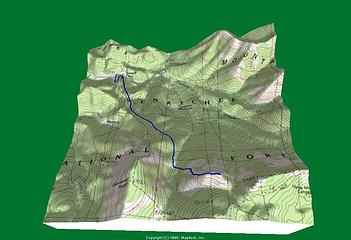
| wildernessed wrote: | unnamed peak route |
Cool pics. Sounds like a fun day. Really liked your route map. What did you use to create it?
Life is short, hike hard...
Life is short, hike hard...
|
| Back to top |
|
|
wildernessed
viewbagger
Joined: 31 Oct 2004
Posts: 9275 | TRs | Pics
Location: Wenatchee |
Get er done,you ski and I'll glissade, there are several open slopes top to bottom, in fact some crazy skier went down one after we went through there we saw his marks coming back, he did help smooth out the trail we broke. I just can't grasp the backcountry skiing, never having done it. I listened some guys in Leavenworth Mountain Sports talking about there ski trips yesterday going down Howard and starting avalanches and doing the North Face of Cashmere. That has got to be a rush !
Living in the Anthropocene
Living in the Anthropocene
|
| Back to top |
|
|
wildernessed
viewbagger
Joined: 31 Oct 2004
Posts: 9275 | TRs | Pics
Location: Wenatchee |
I used Maptech Terrain Navigator, I love it's 3D capabilities, even though the user interface for TOPO is better IMO. It gives you a nice visual of your route if you have one planned, looking at the 3D you can plan a route if you don't have one and if you then do a profile of the route and trace the profile it gives you the grade / distance / elevation along the route. We use to put trips together, scan narratives with maps and 3D images into a PDF and email them out to each participant. It put the trip into perspective for everyone going.
Living in the Anthropocene
Living in the Anthropocene
|
| Back to top |
|
|
|
|


