| Previous :: Next Topic |
| Author |
Message |
Karen
Member


Joined: 22 Dec 2001
Posts: 2866 | TRs | Pics
|
|
Karen
Member
|
 Sun Dec 21, 2003 7:59 pm |
|
|
The Fuller Mountain trail is in very poor shape and becoming more of a scramble than a hike. The rock cairn that used to mark the start of the trail is gone -- a pink flag remains to assist those wanting to hike up there but it's much more challenging than it used to be. My sense is that very few people use this trail anymore and if it does not get some traffic on it, it's going to be a "goner" within a year or two. It's a mess. The summit view is worth the effort but if you go up there, take care -- it's all too easy to get turned around on the summit and on short winter days, you can't afford to make mistakes. Still, it was fun -- it's a good workout for the muscles that will get used in scrambles to come and it just felt good to be outside in the fresh air.
The Ten Mile Creek loop near Gate 10 is worth a side-trip. I had never done the whole loop before -- it's very pretty and Ten Mile Creek looks more like a pond in places than a creek. The bridge -- such as it is -- is still standing. Somewhat shakily but standing.
Karen
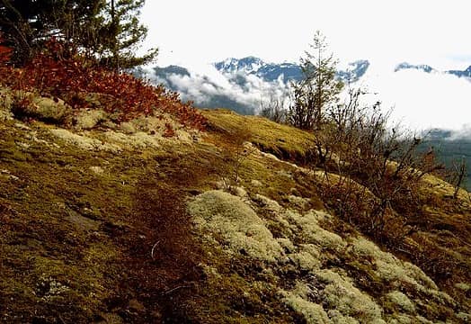 Fuller Mountain summit view 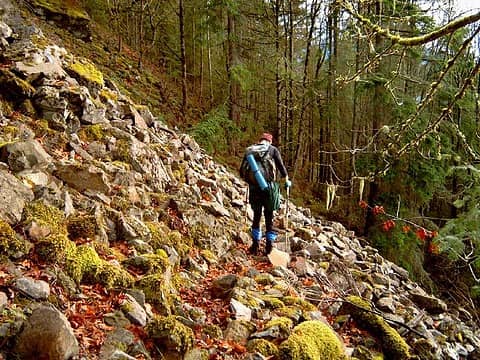 Descending Fuller Mt
stay together, learn the flowers, go light - from Turtle Island, Gary Snyder
stay together, learn the flowers, go light - from Turtle Island, Gary Snyder
|
| Back to top |
  
|
|
lopper
off-route

Joined: 22 Jan 2002
Posts: 845 | TRs | Pics
|
|
lopper
off-route
|
Mon Dec 22, 2003 12:09 am |
|
|
April of '73.
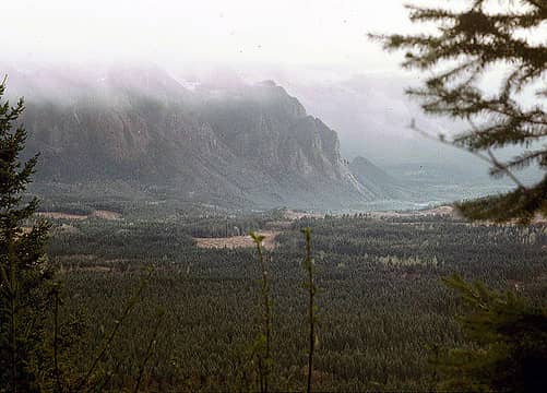
Looking over towards Si from the top of Fuller Mtn.
We got turned around by active avalanche chutes on McClain. No worries on Fuller.
 fuller
|
| Back to top |
|
|
Maarten
Silly

Joined: 29 Nov 2004
Posts: 91 | TRs | Pics
Location: Seattle, WA |
|
Maarten
Silly
|
Tue Nov 30, 2004 12:08 am |
|
|
Karen,
I hiked Fuller Mountain today, inspired by an old copy of Footsore and your article in the P-I (nearly a year ago now, but found via Google).
There's no bridge across Ten Creek anymore--unless I tried to cross in the wrong place. I went in the Ten Creek Loop trail, and where the loop goes left (WeyCo sign on tree, "Red Alder") I went straight/right down to the creek, and found only four logs, with a 3-foot gap full of cold water to leap. Yay for Gore-tex boots! (I made it across and back OK using a fallen branch as a support, but don't recommend that anyone else try this.  The second trail head for the trail up the mountain was completely unmarked: no cairn, no ribbon, nothing. I left a 3-rock cairn, but have to wonder why ribbons would disappear. Once I found the trail, I had no trouble following it, but it had been used the day prior, evidenced by a note left in the geocache at the summit which I happened to see stashed in a hollow tree.
If you're out for views, it's not really a worthwhile climb, IMO. There are some westward views where the trail crosses scree/boulder fields, but no panoramic views from the summit--at best bits and peeks between trees.
I had no trouble staying oriented on the summit, but it'd be nice if there was an indication where the trail is for those who come up a different way. There are plenty of tape/ribbon bits up there, but they were either left by bushwackers or serve a different purpose altogether.
There was a dusting of snow on the summit, but none on the trail.
On the way back, I tried to complete the Ten Creek Loop, but it seemed to peter out and I was tired of bushwacking, having done plenty of that on my creative way up Fuller.
The second trail head for the trail up the mountain was completely unmarked: no cairn, no ribbon, nothing. I left a 3-rock cairn, but have to wonder why ribbons would disappear. Once I found the trail, I had no trouble following it, but it had been used the day prior, evidenced by a note left in the geocache at the summit which I happened to see stashed in a hollow tree.
If you're out for views, it's not really a worthwhile climb, IMO. There are some westward views where the trail crosses scree/boulder fields, but no panoramic views from the summit--at best bits and peeks between trees.
I had no trouble staying oriented on the summit, but it'd be nice if there was an indication where the trail is for those who come up a different way. There are plenty of tape/ribbon bits up there, but they were either left by bushwackers or serve a different purpose altogether.
There was a dusting of snow on the summit, but none on the trail.
On the way back, I tried to complete the Ten Creek Loop, but it seemed to peter out and I was tired of bushwacking, having done plenty of that on my creative way up Fuller.
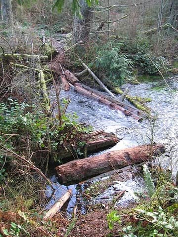 Ten Creek crossing on the way to Fuller Mtn.
|
| Back to top |
|
|
evergreenhiker
Hiking Specialist

Joined: 13 Nov 2004
Posts: 367 | TRs | Pics
Location: Gold Bar |
Sure it wasn't a letterbox? I'm not aware of a geocache being up on Fuller, unless it's via the other geocaching site Navicache.
I have a couple of boxes out in that area...one takes you to a little lake that could really use a Trash out exercise and the other takes you to a very nice viewpoint. Both can be reached via the mainline.
The alpine world is my church.
The alpine world is my church.
|
| Back to top |
|
|
Maarten
Silly
Joined: 29 Nov 2004
Posts: 91 | TRs | Pics
Location: Seattle, WA |
|
Maarten
Silly
|
Tue Nov 30, 2004 2:51 am |
|
|
| evergreenhiker wrote: | | Sure it wasn't a letterbox? I'm not aware of a geocache being up on Fuller, unless it's via the other geocaching site Navicache. |
Ah yes, it may well be. I'm naive about the difference. Geocaches usually have a gift of some sort in them? This was just a stash of note papers + pencil.
|
| Back to top |
|
|
hikerjo
Member
Joined: 05 Sep 2002
Posts: 752 | TRs | Pics
|
|
hikerjo
Member
|
Tue Nov 30, 2004 8:12 am |
|
|
Thanks for the report and trail decriptions. This one is on my to do. I hope to do it in the next couple of weeks. 
|
| Back to top |
|
|
Maarten
Silly
Joined: 29 Nov 2004
Posts: 91 | TRs | Pics
Location: Seattle, WA |
|
Maarten
Silly
|
Tue Nov 30, 2004 10:58 am Another Fuller Mtn report
|
|
|
After I posted, I found another trip report here that closely resembles my experience.
|
| Back to top |
|
|
evergreenhiker
Hiking Specialist
Joined: 13 Nov 2004
Posts: 367 | TRs | Pics
Location: Gold Bar |
| Maarten wrote: | | evergreenhiker wrote: | | Sure it wasn't a letterbox? I'm not aware of a geocache being up on Fuller, unless it's via the other geocaching site Navicache. |
Ah yes, it may well be. I'm naive about the difference. Geocaches usually have a gift of some sort in them? This was just a stash of note papers + pencil. |
sounds like a letterbox or even a summit register. Did you see stampings? Letterboxing involves those. If no, probably summit register.
The alpine world is my church.
The alpine world is my church.
|
| Back to top |
|
|
moosefish
I am the fish

Joined: 02 Jul 2004
Posts: 1209 | TRs | Pics
Location: monkey herder |
|
moosefish
I am the fish
|
Wed Dec 01, 2004 9:51 am |
|
|
| Maarten wrote: | | There's no bridge across Ten Creek anymore--unless I tried to cross in the wrong place. I went in the Ten Creek Loop trail, and where the loop goes left (WeyCo sign on tree, "Red Alder") I went straight/right down to the creek, and found only four logs, with a 3-foot gap full of cold water to leap. Yay for Gore-tex boots! (I made it across and back OK using a fallen branch as a support, but don't recommend that anyone else try this. ; |
I hiked Fuller back in August. I had only one pic of the bridge area (with my stinky dog, Tokul, in the middle), but back then it was an easy walk with no jumping. Especially good with a squirmy kid on my back.
The other added bonus to a summer hike were the huckleberries EVERYWHERE on the summit.
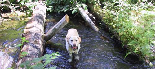 Ten Creek crossing.
|
| Back to top |
|
|
Maarten
Silly
Joined: 29 Nov 2004
Posts: 91 | TRs | Pics
Location: Seattle, WA |
|
Maarten
Silly
|
Sun Nov 19, 2006 1:25 pm Fuller Mtn bridge
|
|
|
Since we couldn't get to Sunday Creek/Sunday Lake, yesterday we stopped at Spur 10 and went up Fuller Mtn instead.
There's a PERFECTLY good bridge across Ten Creek that I must have missed the first time there two years ago. It's easy to miss: when you're looking at the old crossing, it's on your right, behind a rise. Huge tree trunk, top planed flat, with a rope handrail. Easy, easy crossing.
Last time I saw metal tree blazes, this time I could not find any. It appears that the Green River College folks have decided that they're not proud anymore of the trail they built, and took 'em down?  As I was hiking I couldn't help thinking snarky thoughts like "Apparently they don't have any classes in trail maintenance ". It's a tricky trail with all the leaves and loose material.
Couldn't find the "mailbox"/"summit register" at the top this time.
Pics below of the bridge and the state of the trail.
Bridge
Yes, that's the trail. As I was hiking I couldn't help thinking snarky thoughts like "Apparently they don't have any classes in trail maintenance ". It's a tricky trail with all the leaves and loose material.
Couldn't find the "mailbox"/"summit register" at the top this time.
Pics below of the bridge and the state of the trail.
Bridge
Yes, that's the trail.
|
| Back to top |
|
|
moosefish
I am the fish
Joined: 02 Jul 2004
Posts: 1209 | TRs | Pics
Location: monkey herder |
|
moosefish
I am the fish
|
Sun Nov 19, 2006 3:24 pm |
|
|
| Maarten wrote: | | Since we couldn't get to Sunday Creek/Sunday Lake, yesterday we stopped at Spur 10 and went up Fuller Mtn instead. |
Couldn't get to Sunday Creek/Lake? Too much snow or washout on the road?
|
| Back to top |
|
|
Maarten
Silly
Joined: 29 Nov 2004
Posts: 91 | TRs | Pics
Location: Seattle, WA |
|
Maarten
Silly
|
Sun Nov 19, 2006 3:37 pm |
|
|
According to signs, the bridge across Sunday Creek is closed.
Must have been damaged; I didn't go investigate since there's a big ROAD CLOSED sign at the Spur 10 intersection and my hiking partner isn't as gung ho for exploration. I heard that the bridge is passable by hikers and motos.
King County lists it as closed for repairs.
http://www.metrokc.gov/kcdot/roads/roadalert/
|
| Back to top |
|
|
|
|
You cannot post new topics in this forum
You cannot reply to topics in this forum
You cannot edit your posts in this forum
You cannot delete your posts in this forum
You cannot vote in polls in this forum
|
Disclosure: As an Amazon Associate NWHikers.net earns from qualifying purchases when you use our link(s). |


