| Previous :: Next Topic |
| Author |
Message |
harinama
Member

Joined: 14 May 2004
Posts: 122 | TRs | Pics
|
|
harinama
Member
|
 Wed Jul 07, 2004 10:34 am |
|
|
First of all let me say this is one of the best 2day loops i've ever done. Decent trail, amazing views, and few other hikers. I got the chance to try out my new hiking poles(black diamond flick lock Access), which definitely took some time getting used to.
Arrived at the parking area at the end of hwy 63 around 11am. Since i decided to do the loop clockwise, i enjoyed a 1.5 mile walk on the gravel road due to it's poor condition. Trailhead to trail 1051 didn't have a signin, which i thought was pretty strange. Best to sign in at the parking area so there is some record of your entry.
Hike up trail 1051 was consistent and rather uneventful, save for the increasing views gained while slowly rising out of the deep valley. Overall elevation gains are slow for the first 5 miles, then increase somewhat as you start to switchback up to the ridgeline.
Crossing the N. Fork Skykomish presented an interesting problem, however. I went upstream a bit and found a nice large log to cross on. I then picked up the trail (or what i thought was the trail) soon after. I'm thinking that the actual trail was rerouted and this was an old trail (which i noticed a lot of on the hike). It was rather faint in places and i reached a difficult bridge washout about 2 miles later(not mentioned in any trail guides i've seen) After about 10minutes of contemplation, i was able to navigate the crossing by going up stream and "sliding" down the loose cliff face. while not death defying, it's easy to see how an injury could easily occur. Soon after the trail seemed vibrant again, so i must have picked up the main trail again. After a few miles I finally hit dishpan gap.
Strangely, while there are consistently trail markers at crossroads, i did not find a single attraction sign(which is nice to verify your position). After a short respite, I continued on along the PCT over Wards Pass and down to SallyAnn Lake. I began to notice some significant pain in my left knee
which i've never had before. I'm thinking that maybe the poles were causing me to hike in a different manner (quite possibly fixing a gait problem i've always had).
At this point, the scenery was gorgeous with wonderful views to the east and south. SallyAnne lake is still largely snowcovered and sits below some sweet rock formations. I was about 11 miles into the loop, and decided to camp there, knowing full well that my next day would be about 15 miles. The wind blew like crazy in the early evening, making me wonder if my new Squall tarptent would just fly off into the valley below. Luckily i had it staked firmly, and it provided more than ample space for my aching bones and gear. I could tell it is still early in the summer, as the temperature plummeted as the sun went down(I noticed additional ice on the lake in the morning, so it's possible it hit freezing). I slept like a baby, and awoke to an incredible cloudless sky the next morning.
I packed up quickly and hit the trail by ~7am. The ridge trail has a lot of ups and downs, but generally i was too entranced by the views to even notice it. I also found this section to be rather showfree between Skykomish Peak and Cady Pass(again unmarked). My left knee began to give me some major pain, so I put on my brace(which i seldom use). Strangely, my right knee also began to have the same pain (like maybe the outside crossover ligament?...no idea). However, with 11miles still to go, i plunged onward quickly.
After Cady Pass, the trail descends into a Pass Creek Valley. If you want to shorten the loop a bit, You may take the Pass Creek Trail back over to 1051. I decided to go on up towards BenchMark Mountain towards the pct/1054 junction. This set of long switchbacks up the next ridge takes you near an incredible large rock wall that just seem made for climbing.(note to self for future). As i reached the ridge, I took another break here to rest and soak up the scenery. A long traverse, and you hit the pct/1054 junction.
I noticed a large black animal about 30meters away scurry off as i approached. At first i thought it was a wolf, but it ended up a young/ juvenile bear. I hate to see young bears, as usually there is a mother close by. Since he ran off on the trail i had to take, i made a bit of noise with my poles hoping to give momma notice i was coming. Luckily i saw neither as i headed up the trail.(btw, this is the closest encounter of a bear i've ever had), i had the joy of noticing there was another nearby ridge to be gained before the traverse over to Bench Mark Mtn.
As i cruised on over to West Cady Ridge, I noticed quite a number of snow fields to be traversed. The snow was pretty solid, so no post holing. However, it was devilish on my knees! More excellent views and a bunch of ups and downs as you traverse the ridge. This stretch seems to be somewhat low on water, so i filled up on melting runoff early on. At around the 10mile mark for the day, the trail began it's long descent into the N. fork Skykomish valley. Unfortunately, downhill seems to be my nemesis, as both knees began to give me severe pain. I hobbled down the switch backs at a slow pace, and felt my feet blister up like no tomorrow. I "think" the poles helped some, but my endorphins were kicking in and i couldnt even think straight. I saw a deer and a grouse on this section. Finally i got down to the river, and soon after the car.
Unfortunately, my adventure was far from over. As I was driving out on gravelled 63 at (what i thought was) a proper speed(about 20mph), i hit a bad patch of road and bottomed out. I received a new message on my dash "STOP THE CAR OIL IS LOW". So i stopped and put some oil in, and noticed to my dismay that it ended up all over the road. I had gashed my oil pan on the bump. ARGH. To make a long story short..got a ride from a nice family who transported me towards Index. We waved down a ranger who took me back to my car and called a tow truck. Ranger "Brad" was awesome and gave me some cookies as consolation (after running my id to ensure i wasn't america's most wanted). The tow truck took me to Sultan and dropped me and my car off at Wigleys Auto Repair.
I ate an incredible dinner at the Dutch Cup(which have awesome swiss garden burgers btw), called my wife and jumped on the last bus heading toward Everett (indeed bus service goes all the way out to Goldbar!) 3 hours of bussing and i was home safe at 11pm, albiet carless. Car is being worked on today, and I "should" be able to get it later tonight,barring any additional problems(like a siezed engine).
So..an incredible weekend in many ways. I definitely paid for the incredible views with blood/sweat/tears and lots of CASH.
If you head up 63 PLEASE go slowly on the gravel section, and hail salute to me as you pass the nasty section(which you wont even prolly see until you hit it..).
As Ranger Brad says "go slow enough that you can stop in 1/2 the distance you can see and 10mph slower than you think is safe".
 
|
| Back to top |
  
|
|
-lol-
Member

Joined: 17 Dec 2001
Posts: 767 | TRs | Pics
|
|
-lol-
Member
|
Wed Jul 07, 2004 10:31 pm |
|
|
|
| Back to top |
|
|
harinama
Member
Joined: 14 May 2004
Posts: 122 | TRs | Pics
|
|
harinama
Member
|
Thu Jul 08, 2004 8:00 am |
|
|
update:
picked up the car(a 2000 volks passat wagon with an ALUMINUM oil pan..). Everything is fine and got it home w/o mishap.
note to self: SLOW on forest roads!

|
| Back to top |
|
|
jimmymac
Zip Lock Bagger

Joined: 14 Nov 2003
Posts: 3704 | TRs | Pics
Location: Lake Wittenmyer, WA |
|
jimmymac
Zip Lock Bagger
|
Thu Jul 08, 2004 12:21 pm |
|
|
Did the ranger seem concerned about oil? If a municipal employee had witnessed the same thing in the industrial area of Seattle, it would have resulted in a major conniption and a concerted clean-up effort.
"Profound serenity is the product of unfaltering Trust and heightened vulnerability."
"Profound serenity is the product of unfaltering Trust and heightened vulnerability."
|
| Back to top |
|
|
Sore Feet
Member

Joined: 16 Dec 2001
Posts: 6305 | TRs | Pics
Location: Out There, Somewhere |
Funny, I was up on 63 last saturday, and I didn't see any obvious places where oilpanning would incur that much damage. 
|
| Back to top |
|
|
harinama
Member
Joined: 14 May 2004
Posts: 122 | TRs | Pics
|
|
harinama
Member
|
Thu Jul 08, 2004 1:59 pm |
|
|
yeah, the ranger checked out the oil..however i had driven a mile or so before i even knew what was happening. He would have had me clean it up, but it was spread over a long distance. I'm always very conciencious(sp?) about everything in the wilderness and it totally bummed me out. But not a whole lot i could do about it really, considering the circumstance.  The problem area is about 2mi after you start on the gravel. I think it's a lot worse coming out than going in for some reason. I must have hit it "just right" or something..
|
| Back to top |
|
|
Nomad
Member

Joined: 03 Mar 2004
Posts: 283 | TRs | Pics
Location: Auburn WA |
|
Nomad
Member
|
Thu Jul 08, 2004 5:24 pm |
|
|
My daughter gashed her oil pan at Lake Wenatchee on her VW Jetta. I believe they are similar or the same as the Passats. Cost around $400.
"Of all the fire mountains which, like beacons, once blazed along the Pacific Coast, Mount Rainier is the noblest." - John Muir
"If the path be beautiful, let us not ask where it leads." - Anatole France
"Of all the fire mountains which, like beacons, once blazed along the Pacific Coast, Mount Rainier is the noblest." - John Muir
"If the path be beautiful, let us not ask where it leads." - Anatole France
|
| Back to top |
|
|
Slugman
Its a Slugfest!

Joined: 27 Mar 2003
Posts: 16874 | TRs | Pics
|
|
Slugman
Its a Slugfest!
|
Thu Jul 08, 2004 7:34 pm |
|
|
Sorry about your car. Now let's talk hiking! Did you head to the left (north)at Dishpan even a little so you could look down on Meander Meadow? Or get the wonderful view of Glacier Peak that is just a short way north from Dishpan? If not, then you must go back.  That is my favorite area, and I'm glad to hear that it's open for regular hikers. There is much more to do and see up there, like Kodak peak, Blue lake, Indian pass, etc. I'd be going this week or next if I wasn't heading to Oregon and California with Tanja and Daisy to do some tourist stuff for a couple of weeks. I love family vacations, but they do eat into my backpacking time! That is my favorite area, and I'm glad to hear that it's open for regular hikers. There is much more to do and see up there, like Kodak peak, Blue lake, Indian pass, etc. I'd be going this week or next if I wasn't heading to Oregon and California with Tanja and Daisy to do some tourist stuff for a couple of weeks. I love family vacations, but they do eat into my backpacking time!
|
| Back to top |
|
|
Quark
Niece of Alvy Moore

Joined: 15 May 2003
Posts: 14152 | TRs | Pics
|
|
Quark
Niece of Alvy Moore
|
Fri Jul 09, 2004 11:30 am |
|
|
| Slugman wrote: | | Did you head to the left (north)at Dishpan even a little so you could look down on Meander Meadow? Or get the wonderful view of Glacier Peak that is just a short way north from Dishpan? |
anyone who has a map and can see what he or she would be in for if they did walk that extra mile beyond Dishpan Gap would certainly figure out they should do that! *
*this is a totally mentally challenged sentence, and I know that. I no longer care about grammar or spelling, and hereby pass the Grammar Badge on. Wow, I can't believe I just said that. I can't believe I believe that. Will it last?????
"...Other than that, the post was more or less accurate."
Bernardo, NW Hikers' Bureau Chief of Reporting
"...Other than that, the post was more or less accurate."
Bernardo, NW Hikers' Bureau Chief of Reporting
|
| Back to top |
|
|
jimmymac
Zip Lock Bagger
Joined: 14 Nov 2003
Posts: 3704 | TRs | Pics
Location: Lake Wittenmyer, WA |
|
jimmymac
Zip Lock Bagger
|
Fri Jul 09, 2004 11:34 am |
|
|
| Quark wrote: | | I...hereby pass the Grammar Badge on...Will it last????? |
Let's see if it's gonna last: "Who did you pass the badge to?"
"Profound serenity is the product of unfaltering Trust and heightened vulnerability."
"Profound serenity is the product of unfaltering Trust and heightened vulnerability."
|
| Back to top |
|
|
Quark
Niece of Alvy Moore
Joined: 15 May 2003
Posts: 14152 | TRs | Pics
|
|
Quark
Niece of Alvy Moore
|
Fri Jul 09, 2004 11:38 am |
|
|
| jimmymac wrote: | | Quark wrote: | | I...hereby pass the Grammar Badge on...Will it last????? |
Let's see if it's gonna last: "Who did you pass the badge to?" |
anyone who wants it, buddy. 'cause I don't care about such trivial matters any longer. dicey mentioned we need an english major on the site. she's an english major. Major English. General English. Admiral English.
i care so little that even Loggerman or Backpacker Joe can have the job. That's how little I care. Ha!!!!!!!!!!!!!!!!!!!!!!!!!!!!!!!!!!!!!!!!!!!!!!!!!!!!!!!!!!!!!!!!!!!!!!!!!!!!!!!!!!!
"...Other than that, the post was more or less accurate."
Bernardo, NW Hikers' Bureau Chief of Reporting
"...Other than that, the post was more or less accurate."
Bernardo, NW Hikers' Bureau Chief of Reporting
|
| Back to top |
|
|
harinama
Member
Joined: 14 May 2004
Posts: 122 | TRs | Pics
|
|
harinama
Member
|
Fri Jul 09, 2004 3:26 pm |
|
|
/cry!
nope didnt head north of dishpan gap. The views were totally sweet where i was, but that extra 2 miles woulda literally killed me.
anyone got picks of meander meadow?
Also, i had sweet views of mt adams, and another mountain. I thought it could be glacier peak, but it didnt seem to have a lot of snow on it..hmmm
|
| Back to top |
|
|
ridgescrambler
Member

Joined: 28 Mar 2004
Posts: 83 | TRs | Pics
Location: Tacoma, WA |
oh man that stinks - what an end to a great trip - hope you are still up for Northern Loop the end of this month!
Go to the mountains - for only there are you truly free......
Go to the mountains - for only there are you truly free......
|
| Back to top |
|
|
Slugman
Its a Slugfest!

Joined: 27 Mar 2003
Posts: 16874 | TRs | Pics
|
|
Slugman
Its a Slugfest!
|
Fri Jul 09, 2004 9:42 pm |
|
|
Here is a shot of Glacier from the campsite area just north of Dishpan, and a shot from Meander meadow looking up to the PCT. I did this trip in very late August '02, and there was still lots of snow at Sally-Ann and in Meander meadow! There were also still awesome flower displays on Cady ridgeas well.
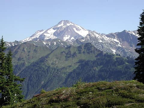 Glacier peak from just north of dishpan 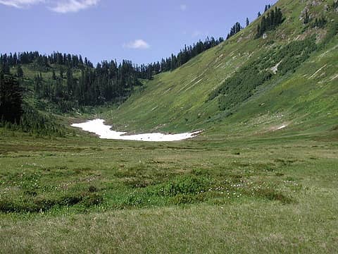 Meander meadow looking up towards PCT
|
| Back to top |
|
|
|
|
You cannot post new topics in this forum
You cannot reply to topics in this forum
You cannot edit your posts in this forum
You cannot delete your posts in this forum
You cannot vote in polls in this forum
|
Disclosure: As an Amazon Associate NWHikers.net earns from qualifying purchases when you use our link(s). |


