| Previous :: Next Topic |
| Author |
Message |
Yana
Hater


Joined: 04 Jun 2004
Posts: 4212 | TRs | Pics
Location: Out Hating |
|
Yana
Hater
|
 Thu Jun 28, 2007 8:36 pm |
|
|
| Joe wrote: | Yana...your pack looks bigger than you  .
I guess you are not in the go lite crowd (me neither, I'm a member of the go heavy crowd .
I guess you are not in the go lite crowd (me neither, I'm a member of the go heavy crowd  ) ) |
Heh, it was bigger than me.
Everyone else was smart and had a summit pack. I had to lug that thing all the way up (albeit a bit emptier) on summit day. I am a member of the go heavy crowd, but by necessity, not by choice!
<pokes Matt> Where's the rest of the TR? Some of us are impatient to know what happened! ;-)
PLAY SAFE! SKI ONLY IN CLOCKWISE DIRECTION! LET'S ALL HAVE FUN TOGETHER!
PLAY SAFE! SKI ONLY IN CLOCKWISE DIRECTION! LET'S ALL HAVE FUN TOGETHER!
|
| Back to top |
  
|
|
dacker
little black dots

Joined: 27 Sep 2006
Posts: 738 | TRs | Pics
Location: the end of my rope |
|
dacker
little black dots
|
Thu Jun 28, 2007 9:55 pm |
|
|
Well, I went rock climbing yesterday at Mt. Erie with Yana, so she pretty much filled me in on the rest of the story...BUT...
I'm still waiting (impatiently) to read chapter 2 of the TR!! 
We don't stop hiking because we grow old; we grow old because we stop hiking. --Finis Mitchell
We don't stop hiking because we grow old; we grow old because we stop hiking. --Finis Mitchell
|
| Back to top |
|
|
Jamin Smitchger
Member

Joined: 02 Oct 2004
Posts: 673 | TRs | Pics
Location: Pullman |
This trip report should not be on some climbing site. Good job.
|
| Back to top |
|
|
Quark
Niece of Alvy Moore

Joined: 15 May 2003
Posts: 14152 | TRs | Pics
|
|
Quark
Niece of Alvy Moore
|
Thu Jun 28, 2007 10:14 pm |
|
|
 Matt I'm so glad you showed up on this site. What a great trip report & pics.
Damn, Yana gets out a lot. Matt I'm so glad you showed up on this site. What a great trip report & pics.
Damn, Yana gets out a lot.
"...Other than that, the post was more or less accurate."
Bernardo, NW Hikers' Bureau Chief of Reporting
"...Other than that, the post was more or less accurate."
Bernardo, NW Hikers' Bureau Chief of Reporting
|
| Back to top |
|
|
Matt
Tea, Earl Grey, Hot

Joined: 30 Jan 2007
Posts: 4308 | TRs | Pics
Location: Shoreline |
|
Matt
Tea, Earl Grey, Hot
|
Fri Jun 29, 2007 2:00 am |
|
|
Part 2 of 3
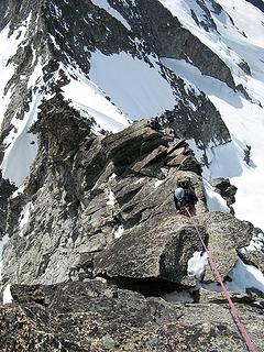
The ridge ended up requiring a running belay for several rope lengths, a full-length belayed pitch up the tower before the west summit, another full-rope belayed pitch to the top of the west (false) summit, and a short pitch down and up to the east (true) summit.
Running belay from col to base of first tower:
Greg led the first rope with Eric, and I followed on the second rope with Yana. For the first couple hundred feet along the ridge, we could just kick steps in the snow. As the ridge steepened, the snow thinned, and footwear changed. First we shed the crampons, then the ice axes. As the rock steepened, Eric & Yana changed to rock shoes, but Greg and I stayed with boots.
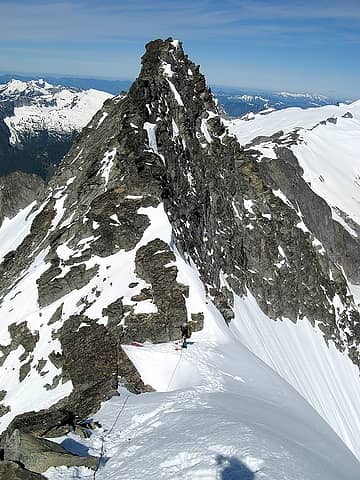 Yana at the col waiting to start up the snowy traverse 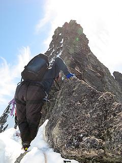 Eric reaching the end of the snow, with the first tower ahead 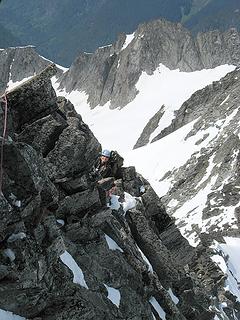 Yana on steepening terrain nearing first anchor. 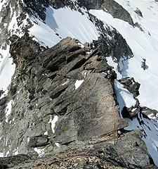 Airy terrain on the ridge  The famous fixed pin, located at bottom of previous photo 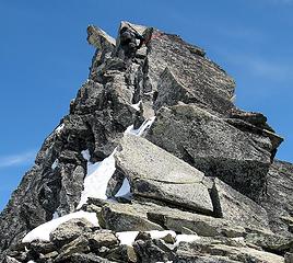 Eric nearing false summit 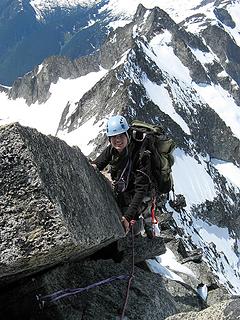 Yana arriving at false summit 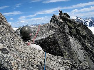 Greg belaying Eric to the summit. 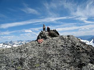 Yanas hand going over the edge. 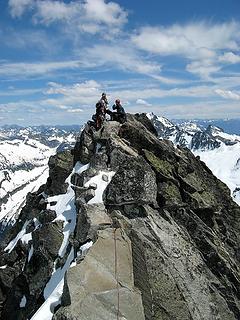 Greg, Yana, & Eric on the summit. 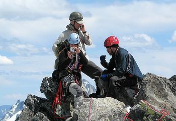 Fone, foto & food on forbidden 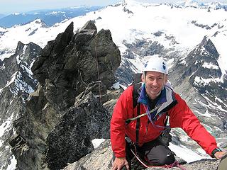 Matt at the summit 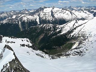 Logan 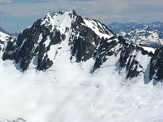 Buckner, Ripsaw Ridge, & Boston Glacier 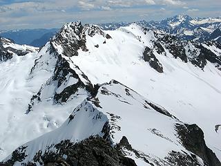 Boston, Sahale, & Bonanza 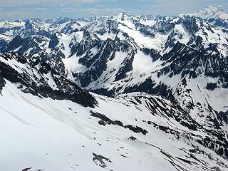 Cascade Pass, Ptarmigan Traverse, & Glacier Peak 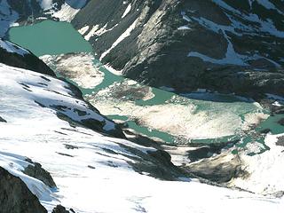 Morraine Lake 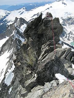 Greg on the false summit 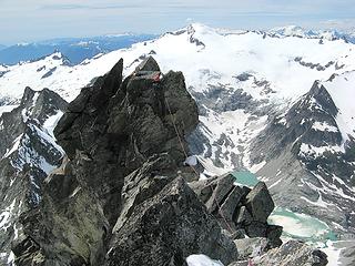 Eric at the step to the false summit 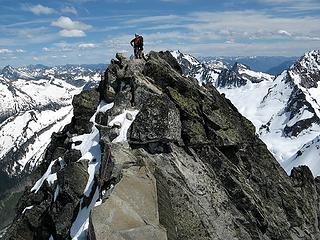 Yana waiting to depart 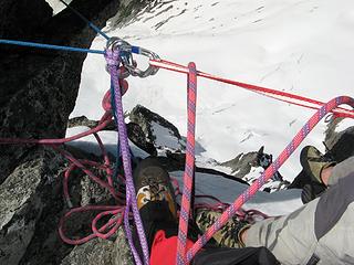 Somehow the diagrams in Freedom never look this messy 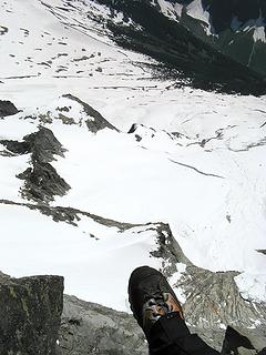 Toe 8800, slab below toe 7800, camp near top of pic 5700.
As beacons mountains burned at evening. J.R.R. Tolkien
As beacons mountains burned at evening. J.R.R. Tolkien
|
| Back to top |
|
|
Don
Member

Joined: 25 Apr 2005
Posts: 2013 | TRs | Pics
Location: Fairwood, WA |
|
Don
Member
|
Fri Jun 29, 2007 7:41 am |
|
|
Wow! What a great trip report and photo essay Matt! That was an incredible trip - thanks for sharing! I just wasted about an hour of my morning following this from beginning to end, and think I'll go back and read again...  Good stuff!
|
| Back to top |
|
|
Yana
Hater
Joined: 04 Jun 2004
Posts: 4212 | TRs | Pics
Location: Out Hating |
|
Yana
Hater
|
Fri Jun 29, 2007 7:44 am |
|
|
Well, Matt's got all the good photos, but here are some more:
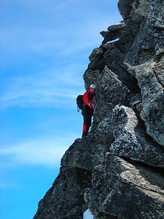 Matt leading 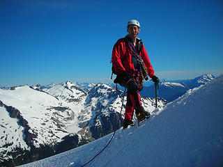 Matt 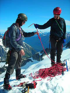 Roping up 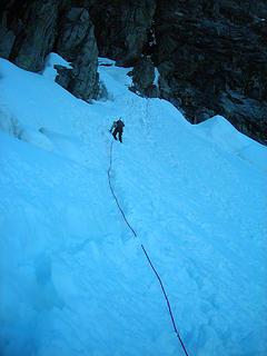 Up the Couloir 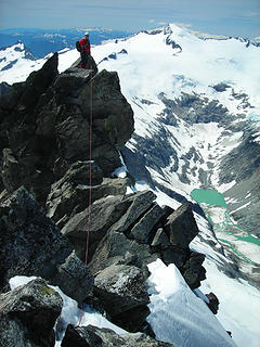 Matt on West Summit 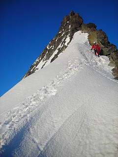 Finally done with the ridge... 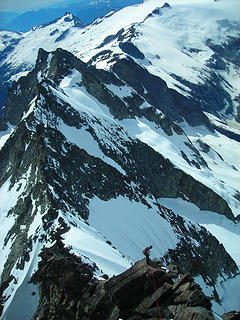 Greg perched on West Ridge
PLAY SAFE! SKI ONLY IN CLOCKWISE DIRECTION! LET'S ALL HAVE FUN TOGETHER!
PLAY SAFE! SKI ONLY IN CLOCKWISE DIRECTION! LET'S ALL HAVE FUN TOGETHER!
|
| Back to top |
|
|
dacker
little black dots
Joined: 27 Sep 2006
Posts: 738 | TRs | Pics
Location: the end of my rope |
|
dacker
little black dots
|
Fri Jun 29, 2007 8:09 am |
|
|
We don't stop hiking because we grow old; we grow old because we stop hiking. --Finis Mitchell
|
| Back to top |
|
|
Matt
Tea, Earl Grey, Hot
Joined: 30 Jan 2007
Posts: 4308 | TRs | Pics
Location: Shoreline |
|
Matt
Tea, Earl Grey, Hot
|
Fri Jun 29, 2007 10:48 am |
|
|
If you look closely at Yana's last photo "Greg perched West Ridge", you can see our tracks topping out the gully in the lower left corner. Yikes, steep looking from that angle.
And, yes, photo visibility is exactly the reason I bought the red jacket. I got tired of blending into the background.
As beacons mountains burned at evening. J.R.R. Tolkien
As beacons mountains burned at evening. J.R.R. Tolkien
|
| Back to top |
|
|
Sabahsboy
Member

Joined: 18 Jul 2006
Posts: 2484 | TRs | Pics
Location: SW Sno County |
Just plain magnificent, the climb and the treasures of panos. Thanks for sharing! I'll be looking at these photos many times in the future!
Never attempted anything like this climb; my "hikes" up Sahale were most satisfying. I concluded that the view southward has to be one of the very best in WA, perhaps in Lower 48; the waves of rugged, ragged peaks face north and are draped in every fashion with mantels of snow and ice. Your photos certainly portray the vision in ultimate terms.
|
| Back to top |
|
|
Mesahchie Mark
A Lerxst

Joined: 10 May 2005
Posts: 700 | TRs | Pics
Location: In Wonderland |
Damn.
|
| Back to top |
|
|
Matt
Tea, Earl Grey, Hot
Joined: 30 Jan 2007
Posts: 4308 | TRs | Pics
Location: Shoreline |
|
Matt
Tea, Earl Grey, Hot
|
Sat Jun 30, 2007 12:13 am |
|
|
Part 3 of 3
Our descent down the ridge was tediously slow. Were redeemed only by the fact that this route has seen some epic prolonged trips, along with some remarkably fast ones. For us, the pace was a combination of factors. The party had different levels of experience and comfort levels for steep terrain. There was an objective hazard from thin patches of snow, which would occasionally break away underfoot. And the configuration of the descent is just plain awkward, angling along the side of the crest, too vertical for comfortable downclimbing and too horizontal for straightforward rappels. So we chose to protect pretty much the entire descent, even though it was very time-consuming.
From the false summit, we did five rappels back down the route. We did single-rope rappels, in order to shorten the risk of a climber pendulum or a rope hangup on the sideways slanting route. They were awkward rappels, braking with one hand, holding the edge of the rock with the other hand, and finding a balance between leaning sideways and outward enough to keep your footing. We finally arrived back at the col six hours after leaving the summit, eleven hours after we had departed the same spot in the morning.
 Yana rappelling, top of gully in distance (one of the few times the rappel was straight on the crest) 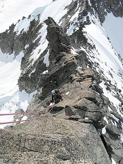 Yana rappelling on one rope while Grey & Eric set up next rappel on other rope. 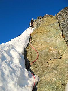 Arriving back on easier terrain 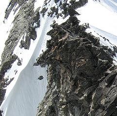 Zoom photo of our steps at the top of the gully 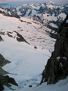 Schrundy stuff at the bottom of the gully 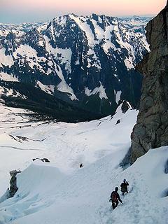 Exiting the gully 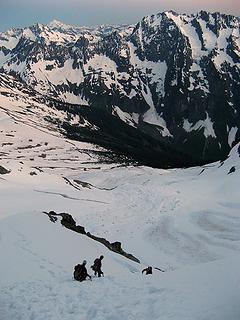 Heading for camp. 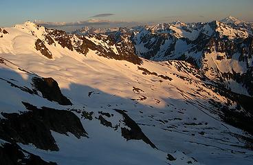 Boston Basin View 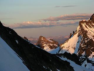 Booker 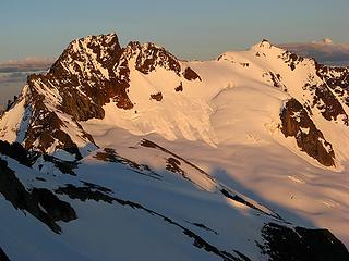 Boston & Sahale 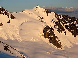 Sahale Quien Sabe Glacier 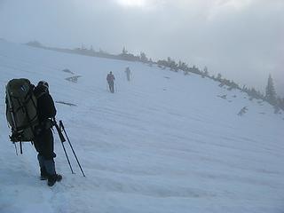 Departing camp in mist 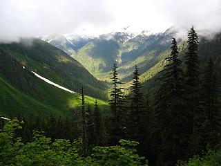 Cascade River Valley viewed from Boston Basin Trail 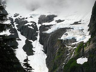 Johannesburg hanging glaciers glowing blue in misty light 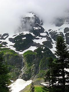 Johannesburg veiled in clouds 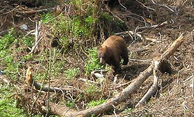 Bear 1 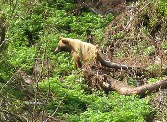 Bear 2
As beacons mountains burned at evening. J.R.R. Tolkien
As beacons mountains burned at evening. J.R.R. Tolkien
|
| Back to top |
|
|
yukon222
Member

Joined: 12 Mar 2007
Posts: 1894 | TRs | Pics
|
|
yukon222
Member
|
Sat Jun 30, 2007 6:35 am |
|
|
Thank you so much for posting a TR with such a detailed description and amazing set of photos! While I'm not a climber and have only read stories about how extremely difficult terrain is conquered, your group's experience and willingness to share it has been very enjoyable to read. Thanks for posting what has to be one of the greatest TR's and photo sets in the history of NWhikers. BTW, is there such a thread?
|
| Back to top |
|
|
touron
Member
Joined: 15 Sep 2003
Posts: 10293 | TRs | Pics
Location: Plymouth Rock |
|
touron
Member
|
Sat Jun 30, 2007 4:12 pm |
|
|
Nice shot of Morraine. I've always wanted a gander of that lake.
Touron is a nougat of Arabic origin made with almonds and honey or sugar, without which it would just not be Christmas in Spain.
Touron is a nougat of Arabic origin made with almonds and honey or sugar, without which it would just not be Christmas in Spain.
|
| Back to top |
|
|
summitseeker
Member
Joined: 31 Mar 2006
Posts: 138 | TRs | Pics
Location: Seattle |
"Find out who you are and then do it on purpose."
www.summitroutes.com : Guidebook to the 100 highest peaks in Washington
|
| Back to top |
|
|
|
|
You cannot post new topics in this forum
You cannot reply to topics in this forum
You cannot edit your posts in this forum
You cannot delete your posts in this forum
You cannot vote in polls in this forum
|
Disclosure: As an Amazon Associate NWHikers.net earns from qualifying purchases when you use our link(s). |


 You guys had a fantastic weather window and a SWEEEET climb! Nice report and pics...chapter 2 definitely worth waiting for.


