inspired by this TR, i headed for rock today. aside from sleeping in (a reoccuring theme of late), the most frustrating thing was finding the trailhead. all i had was my green trails map and topo, but no driving directions. i think i passed the turnoff road several times - which included a stop and walk up a different road first - before finding the right one. i believe (and i forgot to look on the way home) it was between mile post 74 and 75.
the trailhead road meeting hwy 2
trailhead sign warning about avy terrain
anyway, at the trailhead, you follow the powerline road for a decent length before hanging a left and beginning the numerous switchbacks. there was snow the entire way today, obscuring the slick rocks and slabs beneath the highly lubricating snow layer. at times, it was tough to figure out where to go. eventually, as the snow depth increased, i could make out the faint depressions of those that walked the trail earlier in the week after the last snowfall. now, there should be a good beaten down path for anyone deciding to head out sunday.
stay left here instead of making the switchback while under the power lines
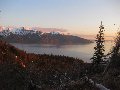
looking down towards hwy 2 valley
freshly fallen
even a touch of blue sky
a highly visible stretch of previous hiker's prints
i thought about heading right here, just to see if there was any active artillery to play with
i believe it was around EL 5200' where the switchbacks stop and you begin to traverse the east side of the ridge. there were no longer indentations here, so i got to wing it. by now, the snow was knee deep, but still okay for just boots. visibility was nil, so i was kind of hiking by braille. even when the terrain opened up, i could only see a bump off in the distance, but nothing i could place on a map.
knee deep without the snowshoes
by EL 6000', i was more than postholing - i was trunkholing (i.e. sinking in to my hips). after about five steps like this, i broke out the snowshoes. i've long wondered just how much snowshoes help in this really soft powdery stuff. today, i got my answer. now, i was only going in to my knees, so
the first bump i could see once in the open terrain
the last 500' were challenging as i couldn't kick in much of a step and the terrain was pretty steep. i could definitely see this area (and a lot of the hike in general) being avalanche prone. perhaps that why there's a note about it on the trailhead sign. anyway, i got to what read out at EL 6921' on my altimeter and the highest point on the three adjoining ridges. i called it good here since i just hit my turnaround time. there was only a dusting of snow on the summit - the wind probably took care of it.
final steep part before the summit
only 200' vertical to go
heading down the steep part without much snow was not so fun, but after that, it was so good, so much fun, skiing my way down through 'balls-deep' powder (a term coined last year with b00 and fastfeet). seeing this beautiful open expanse of snow was just what i needed since, of late, i've been dealing with heavy issues. seeing the snow took me right back to all the wonderful trips i did last winter.
just the right amount of light poking through the clouds for a good pic
ah, happy thoughts
i imagine someone had blue skies somewhere - maybe leavenworth area
if anyone heads up there tomorrow, could you please let me know if i actually reached the true summit?
trip stats:
10 mi
4000'
4.75 hrs
For us height challenged hikers, can you give us an approximation of snow depth? Your waist deep snow may be for some of us. Thanks for the great snow shots, glad you found your happy place! ~Jo
i think this is just about the best illustration i've ever seen. have you had it in your stock file for years for a moment like this, or did you just come up with it? either way, it's awesome.
The above illustration was discovered by way of google using the search words 'short and tall' and is found on wikipedia's explanation of Proportional Reasoning link here which is a long winded way of saying I 'ganked it' from the web
Nice work!
The TH turn-off is between MP 73 and 74, btw...we should have mentioned how it's difficult to find in our TR from last week...there used to be a sign pointing to the TH, but it's gone.
When you got to the summit, it should have been flat on top (with rocks stacked up to create the platform) and you should have been able to see remains of the old lookout that was up there (there was a pipe sticking out of the ground, most noticeably). Did you see any of this?
Nice job, one spot I've been by a thousand times and never hiked. Maybe I can grab it the next few days. I didn't think we had enough snow this past week. I'll be camping just down the road from there, so maybe I should take the snowshoes?
What I really need to know, how many paperclips deep was the snow?......
You call some place paradise, kiss it goodbye......Eagles
0
You call some place paradise, kiss it goodbye......Eagles
Looks borderline like there is enough coverage to ski on the smooth "northwest-ramp" of Rock Mountain, can you confirm yay or ney in regards to this?
Yours Truly,
Desperate.
...there used to be a sign pointing to the TH, but it's gone.
I don't know what's up with that sign: Earlier this year it was up...then, they removed it for most of summer...then, I saw it again during late summer. They must have removed it again, maybe because of avalanche danger (remember they also do avalanche control there).
'Gali'Walker => 'Mountain-pass' walker
bobbi: "...don't you ever forget your camera!"
Photography: flickr.com/photos/shahiddurrani
0
'Gali'Walker => 'Mountain-pass' walker
bobbi: "...don't you ever forget your camera!"
Photography: flickr.com/photos/shahiddurrani
Eastern approach...(Movenhike scratches chin with left index and thumb and gazes diagonally upward northwesterly) that sounds logical based on prevailing wind direction. I've got a rockboard somewhere in my house. This is encouraging.
Thanks for the speedy response
If anyone else out there wants some turns BAD, PM me or whatever. Wednesday sounds semi-promising.
NMH-J
---No More Thread Hi-Jack
You cannot post new topics in this forum You cannot reply to topics in this forum You cannot edit your posts in this forum You cannot delete your posts in this forum You cannot vote in polls in this forum
Disclosure: As an Amazon Associate NWHikers.net earns from qualifying purchases when you use our link(s).


 for some of us. Thanks for the great snow shots, glad you found your happy place! ~Jo

 Good thing it was knee deep or you would have been sub 4:00.


 If anyone else out there wants some turns

