| Previous :: Next Topic |
| Author |
Message |
Tom_Sjolseth
Born Yesterday


Joined: 30 May 2007
Posts: 2652 | TRs | Pics
Location: Right here. |
My Dad, Justus, and I headed up to Elija Ridge this weekend for my second trip in a row up Cabinet Creek. This was my Dad's second trip up there.
Cabinet Creek is melting out fast, but it's still easy to miss brush by walking on consolidated snow. This will last for about another week or two before it becomes - different.
We camped on the ridge at ~6,350', about 1.75 miles E of the summit. Great views to the Chilliwack Group, Gabriel, Beebe, and Red Mountain. We departed camp at 5AM this morning and headed up to the summit. This took longer than we expected, but we eventually made it. The views were outstanding, but not quite as nice as Gabriel. We could see a sliver of Ross Lake, which was nice. Thunderstorms were moving in from the East for the second day in a row, so we decided to boogie. We got back to camp and had everything packed within about 10 minutes. We descended to the creek just as showers began to fall from the sky. The brush was wet on the way down, and by the time we hit the cars we were soaked. We saw Dave Creeden's car parked down at the guardrail and wondered what he might be climbing. I'm guessing Gabriel, and I'm guessing he got wet!
Another great trip in the hills. Justus has photos, but it might take him a little bit to add them.
|
| Back to top |
  
|
|
Justus S.
Member

Joined: 17 Nov 2004
Posts: 1298 | TRs | Pics
Location: WA |
Tom thanks for inviting me to come along on this trip. I had a great time! Beautiful place and good times.
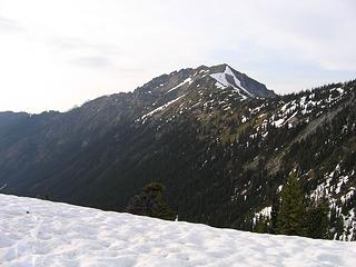 Beebe from camp 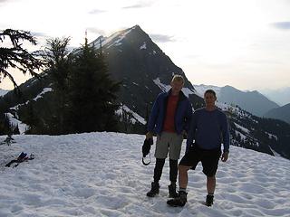 Tom and his Dad at camp, Elija behind 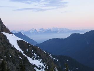 Chilliwacks 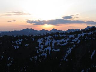 Sun rising 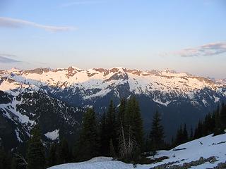 Red Mtn early morning 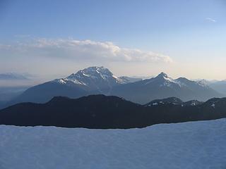 Jack and Crater from east summit 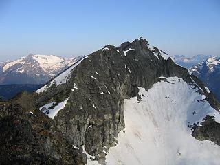 Elijah, from the east summit, still far away 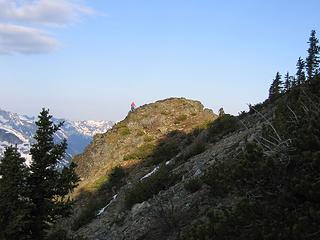 more walking to the summit 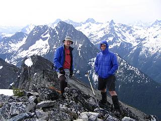 Tom and his Dad on the summit 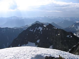 Looking northeast 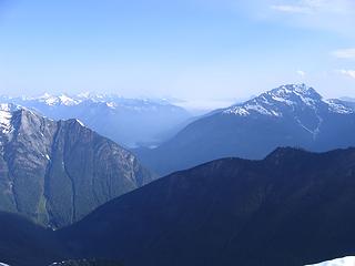 Ross Lake 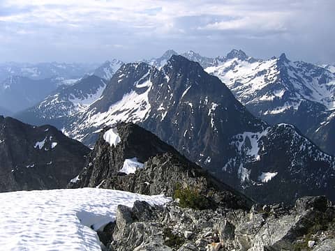 Gabriel and Ragged Ridge 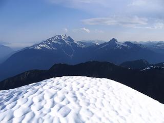 Jack and Crater 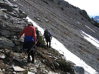 Lots of traversing to be had for Elija 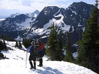 almost to camp
|
| Back to top |
|
|
Martin S
Member

Joined: 06 May 2007
Posts: 181 | TRs | Pics
Location: Out in the perimeter, where there are no stars |
|
Martin S
Member
|
 Sat Jun 13, 2009 9:49 pm |
|
|
So that's whose footprints we saw along Cabinet Creek! Dave Creeden and I climbed Gabriel this morning and when we came back down to the creek we were surprised to find a fresh set of tracks in the snow heading out. I told Dave it was probably somebody we knew because only a crazy peakbagger would be in there.
You guys were right - Gabriel is a very nice climb. Oh, and thanks for the steps!
"nothing's for certain" took the elevator down
while "anything can happen" climbed the stairs
- Ryszard Krynicki
"nothing's for certain" took the elevator down
while "anything can happen" climbed the stairs
- Ryszard Krynicki
|
| Back to top |
|
|
lopper
off-route

Joined: 22 Jan 2002
Posts: 845 | TRs | Pics
|
|
lopper
off-route
|
Sat Jun 13, 2009 9:58 pm |
|
|
Thanks for that report and the magnificent pics.
Here is an inverse shot from Crater looking your way in Sept 98.
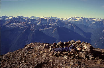 98craternap
|
| Back to top |
|
|
seawallrunner
dilettante

Joined: 27 Apr 2005
Posts: 3307 | TRs | Pics
Location: Lotusland |
good work !!! Wow that's a long climb. With beautiful photographs.
I've admired Elijah Ridge from Ross Lake on a canoe, mid-lake near Big Beaver camp. Justus, in your image called 'view towards eldorado' what is the ridge that spans the middle of the picture?
|
| Back to top |
|
|
cartman
Member
Joined: 20 Feb 2007
Posts: 2800 | TRs | Pics
Location: Fremont |
|
cartman
Member
|
Sat Jun 13, 2009 10:18 pm |
|
|
| seawallrunner wrote: | | good work !!! Wow that's a long climb. With beautiful photographs.
I've admired Elijah Ridge from Ross Lake on a canoe, mid-lake near Big Beaver camp. Justus, in your image called 'view towards eldorado' what is the ridge that spans the middle of the picture? |
Someone labeled the pic--it is Red Mtn, the long western end of Ragged Ridge.
|
| Back to top |
|
|
seawallrunner
dilettante
Joined: 27 Apr 2005
Posts: 3307 | TRs | Pics
Location: Lotusland |
thank you cartman, thank you Tom_Sjolseth for the labels.
|
| Back to top |
|
|
Tom_Sjolseth
Born Yesterday
Joined: 30 May 2007
Posts: 2652 | TRs | Pics
Location: Right here. |
Thanks, Justus, for coming along! Your shots are great, especially the one entitled, "Gabriel".
Martin S. - I had a feeling you were a part of Team Gabriel that day. Did you guys get wet?
lopper, thanks for the photo from Crater.
SWR - it is hard to comprehend how long that Red Mountain ridge is until you see it straight on. I have seen it before from other vantage points, but seeing it from Gabriel and Elija really gave me an appreciation of its magnitude.
|
| Back to top |
|
|
Tom_Sjolseth
Born Yesterday
Joined: 30 May 2007
Posts: 2652 | TRs | Pics
Location: Right here. |
One more interesting note about Elija. The summit benchmark (of which there are two) was originally stamped "Gabriel". Someone then got rid of this and put Elija. I have not seen that before.
|
| Back to top |
|
|
Dave Creeden
Member
Joined: 04 Sep 2007
Posts: 99 | TRs | Pics
|
Tom,
We got a 5:15 start due the weather forecast of thunderstorms, arriving at the summit a little after 9:30 AM. We lounged on the summit for a while, leaving a little after 11AM. I took video from the summit right before we began our descent, that I will post later. At that time there were no nearby threatening thunderheads.
By the time we reached the 6,800 ft elevation on the ridge to drop into the basin on the NE side of Gabriel, I made comment to Martin to look out for pyrotechnics. In that half hour period of time, a thunderhead had build up and moved right over Mebee. We cracked off a series of glissades to quickly descend into the basin and by the time we crossed your guy's fresh tracks a little before noon, Gabriel was getting hammered by thunder and lightning. We didn't get soaked from rainfall, actually getting more wet from trees on our descent.
About what time were you guys traveling down Cabinet Creek?
Did you guys come across the abandoned trail going up Cabinet Creek? We milked this old trail between 3,800 ft and the snow line at about 4,300 ft.
|
| Back to top |
|
|
wildernessed
viewbagger

Joined: 31 Oct 2004
Posts: 9275 | TRs | Pics
Location: Wenatchee |
 Good stuff as usual. Good stuff as usual.
Living in the Anthropocene
Living in the Anthropocene
|
| Back to top |
|
|
Tom_Sjolseth
Born Yesterday
Joined: 30 May 2007
Posts: 2652 | TRs | Pics
Location: Right here. |
You guys were cruising (as always)!
We were coming down cabinet creek around 1PM (I think).
We used the abandoned trail last week as well as this week, it certainly makes things nice.
Looking forward to the TR.
|
| Back to top |
|
|
Andy D.
Member

Joined: 19 Apr 2004
Posts: 209 | TRs | Pics
Location: Bow, WA |
|
Andy D.
Member
|
Sun Jun 14, 2009 3:40 pm |
|
|
Nice work fellas. Great pictures too, and thanks for adding the labels!
|
| Back to top |
|
|
Dave Creeden
Member
Joined: 04 Sep 2007
Posts: 99 | TRs | Pics
|
|
| Back to top |
|
|
raising3hikers
Member
Joined: 21 Sep 2007
Posts: 2344 | TRs | Pics
Location: Edmonds, Wa |
Looked like it was a great time to climb. Nice pics and it's cool that pops made the trip also.
|
| Back to top |
|
|
|
|


