| Previous :: Next Topic |
| Author |
Message |
Bedivere
Why Do Witches Burn?


Joined: 25 Jul 2008
Posts: 7464 | TRs | Pics
Location: The Hermitage |
|
Bedivere
Why Do Witches Burn?
|
 Wed Oct 14, 2009 11:03 pm |
|
|
PART I - Introduction
(To get right to the pics and description, skip to Part II)
Joining this site has been one of the best things I've done. I've met and hiked and skied with some really neat people since joining the fray around here.
Awhile back I was talking about (and asking a lot of questions) about fishing in the Trail Talk forum. Member RPBrown introduced himself to me via PM and invited me to go along on a dayhike with him to check out some lakes I'd never been to and to stock some Golden Trout fry in a small, unnamed lake high on the ridgeline. He's a member of the Trailblazers and offered to answer a lot of my questions about high lakes fishing too so I jumped at the offer.
We talked on the phone and via e-mail a couple times to iron out the details and the hike he described sounded pretty good to me. I never actually looked at a map before the day of the hike as I know the area fairly well though have never been to the places we went to on that day. I was thinking this would be around a 12 mile hike, which for me is a long day, close to the longest thing I've ever done. Turns out it was a good thing I didn't look at the map beforehand or I might have bowed out on this one. Or, I might not have... There's a part of me that thinks if someone else can do it, well by gosh so can I.
Rich was a little hesitant about me bringing Jack along on this trip. I got the impression he doesn't hike with dogs much, or maybe had a bad experience with one in the past. He was afraid that we might encounter terrain too rough for Jack to negotiate or that Jack would jump in the lakes and scare off the fish but after hiking and skiing with Jack for the last 18 mos. I'm confident that Jack can handle just about anything I can and he doesn't like swimming so I talked him into letting Jack come along. I think by the end of the day Jack's ability to handle the terrain we encountered, his energy, and his good nature and reasonably good manners earned Rich's respect. I only hope I can say the same.  PART II - The longest single day hike of my life.
We got on the trail just a bit after 7:30. There was a bit of overcast but the forecast called for improving weather -A chance of showers in the morning with afternoon clearing but cool, with the snow level around 6500 feet in the afternoon.
PART II - The longest single day hike of my life.
We got on the trail just a bit after 7:30. There was a bit of overcast but the forecast called for improving weather -A chance of showers in the morning with afternoon clearing but cool, with the snow level around 6500 feet in the afternoon.
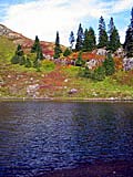
 Sunrise on Nearby Peak from Paddy Go Easy Pass trail.  Looking East from the pass.  Looking down at the meadowy area with distant peaks (Cashmere?)  RPBrown ascending the boulders at the top of the chute we chose. You go through the hole formed by the stacked boulders near the top left - requires a bit of stemming.  Upper French Pothole from near it's outlet.  Looking back down to Upper French Pothole as we climbed the ridge.  Reflection.  Here fishy, fishy, fishy.  Jack looking down at upper Robin Lake from the pass.  Reflection in tarn next to lower Robin Lake.  Late afternoon at Tuck's Pot.
|
| Back to top |
  
|
|
Tazz
Member

Joined: 27 Apr 2005
Posts: 7902 | TRs | Pics
|
|
Tazz
Member
|
Wed Oct 14, 2009 11:15 pm |
|
|
Nice Will!!! great shots and sounds like lots of fun!
|
| Back to top |
|
|
furthur
Berry Bagger

Joined: 21 Sep 2006
Posts: 341 | TRs | Pics
Location: onward and upward |
|
furthur
Berry Bagger
|
Thu Oct 15, 2009 5:38 am |
|
|
This reads like a DayHike Mike adventure, with fish. I bet this gets lots of readers thinking of copying your route, though probably after the snow season.
Good dog, Jack! And same to you, Willie. Twenty mountain miles in one fall day earns you a big shiny medal.
"You're either on the bus or off the bus."
Kesey
"You're either on the bus or off the bus."
Kesey
|
| Back to top |
|
|
DIYSteve
seeking hygge

Joined: 06 Mar 2007
Posts: 12654 | TRs | Pics
Location: here now |
|
DIYSteve
seeking hygge
|
Thu Oct 15, 2009 8:02 am |
|
|
Will, that's a cool iteration of a classic route. Great pics, fun story. 
|
| Back to top |
|
|
reststep
Member
Joined: 17 Dec 2001
Posts: 4758 | TRs | Pics
|
|
reststep
Member
|
Thu Oct 15, 2009 9:41 am |
|
|
Thanks for the report and pictures.
It looks like a fun route that I would like to try, but taking 2 or 3 days.  Your observation about the French Potholes is the same as mine about the Granite Mountain Potholes. I wonder why they gave them that name because they are really beautiful lakes.
"The mountains are calling and I must go." - John Muir
"The mountains are calling and I must go." - John Muir
|
| Back to top |
|
|
ragman and rodman
Member

Joined: 28 Apr 2005
Posts: 1219 | TRs | Pics
Location: http://rgervin.com/ |
Thanks for the up close look at the French Potholes and the unnamed tarns... I've seen the French Potholes from Sherpani Peak and Granite Mtn South Peak (the peak in your "Reflection" and "fishy, fishy" shots)... but never got close to them.
I've never read about anyone visiting the French Potholes... only about those who have used the west side of the ridge to get from Sherpani to the unnamed tarns.
|
| Back to top |
|
|
DIYSteve
seeking hygge
Joined: 06 Mar 2007
Posts: 12654 | TRs | Pics
Location: here now |
|
DIYSteve
seeking hygge
|
Thu Oct 15, 2009 11:50 am |
|
|
| reststep wrote: | | It looks like a fun route that I would like to try, but taking 2 or 3 days. |
PGE Pass (or just below it) to Robin Lakes is a great non-technical cross country route. Feel free to PM me for some route options before you plan your route. And I suggest tagging the summit of Sherpani along the way.
|
| Back to top |
|
|
Randy
Cube Rat

Joined: 18 Dec 2001
Posts: 2910 | TRs | Pics
Location: Near the Siamangs |
|
Randy
Cube Rat
|
Thu Oct 15, 2009 11:53 am |
|
|
Sherpani is definitley worth a visit. One of several surprisingly cool peaks along that ridge.
|
| Back to top |
|
|
fwb
Member
Joined: 16 Oct 2008
Posts: 224 | TRs | Pics
Location: Mukilteo, WA |
|
fwb
Member
|
Thu Oct 15, 2009 12:02 pm |
|
|
Thanks for the nice report and looks like a great trip. Good job Quite a trek for a day trip with snow (for Jack as well). I've been having that route on my back-burner. But with two new oil pans in one season am not feeling the love for that road.
|
| Back to top |
|
|
kleet
meat tornado

Joined: 06 Feb 2002
Posts: 5303 | TRs | Pics
Location: O no they dih ent |
|
kleet
meat tornado
|
Thu Oct 15, 2009 12:50 pm |
|
|
| ragman and rodman wrote: | | I've never read about anyone visiting the French Potholes... |
These  did. did.
A fuxk, why do I not give one?
A fuxk, why do I not give one?
|
| Back to top |
|
|
Roald
Member

Joined: 06 Aug 2007
Posts: 367 | TRs | Pics
Location: Seattle |
|
Roald
Member
|
Thu Oct 15, 2009 2:30 pm |
|
|
Nice trip! And inspiring too.
Years ago my daughter and I named those two tarns on the east side of the Granite Peak ridge: Willy and Roald Lakes. Named after the stuffed bears we always carried. She beat me in a game of Yahtzee after jumping in Willy (the higher) lake. Now, if we could get those names to stick, that would be cool...
|
| Back to top |
|
|
Dayhike Mike
Bad MFKer
Joined: 02 Mar 2003
Posts: 10955 | TRs | Pics
Location: Going to Tukwila |
"There is only one basic human right, the right to do as you damn well please. And with it comes the only basic human duty, the duty to take the consequences." -P.J. O'Rourke
"Ignorance is natural. Stupidity takes commitment." -Solomon Short
|
| Back to top |
|
|
Get Out and Go
Member

Joined: 13 Nov 2004
Posts: 2130 | TRs | Pics
Location: Leavenworth |
Looking at the title of your post, first impression was "Oh, that sounds like a good overnight trip." Then reading through.....OH!...All in a day's work!  Great Trip! Great Trip!
"These are the places you will find me hiding'...These are the places I will always go."
(Down in the Valley by The Head and The Heart)
"Sometimes you're happy. Sometimes you cry.
Half of me is ocean. Half of me is sky."
(Thanks, Tom Petty)
"These are the places you will find me hiding'...These are the places I will always go."
(Down in the Valley by The Head and The Heart)
"Sometimes you're happy. Sometimes you cry.
Half of me is ocean. Half of me is sky."
(Thanks, Tom Petty)
|
| Back to top |
|
|
yukon222
Member

Joined: 12 Mar 2007
Posts: 1894 | TRs | Pics
|
|
yukon222
Member
|
Fri Oct 16, 2009 4:03 pm |
|
|
Quite a trip, mixing in that much off-trail travel, with overall long distance day. Excellent!!
|
| Back to top |
|
|
Magellan
Brutally Handsome

Joined: 26 Jul 2006
Posts: 13116 | TRs | Pics
Location: Inexorable descent |
|
Magellan
Brutally Handsome
|
Fri Oct 16, 2009 8:37 pm |
|
|
Heckuvan effort W! Good on you, RP, and Jack.
|
| Back to top |
|
|
|
|


 Thanks for the TR and nice pics!