| Previous :: Next Topic |
| Author |
Message |
RyanBiggs
Member


Joined: 05 Mar 2010
Posts: 8 | TRs | Pics
|
While I should make it clear I have no intention of trespassing on watershed property, I live along Highway 2 not many miles at all from this reservoir as the crow flies and have a certain fascination with this obviously beautiful and forbidden basin. I'm wondering if anyone knows a publicly accessible vantage point from which one can look down into the watershed. I've done a fair amount of mountain biking in the Hancock lands in the North Fork Tolt valley, and it appears it would be possible (if not exactly easy) to get fairly high up the north face of the ridge to the north of the reservoir on logging roads and then hike up to the ridge line watershed boundary. While I don't know the area, from maps it looks like it might be possible and potentially easier to do something similar on the ridge to the south, which looks to have roads all the way to the ridge line. Anyone have experience with something like this?
On a related note, I would be interested if anyone has any historical information on why there is such a high level of paranoia surrounding watersheds and reservoirs in the Pacific Northwest and Seattle in particular. Having seen first hand how there is a certain element in Western Washington that will trash out and shoot up any area accessible by motor vehicles, I can understand why the city would want to keep motorized traffic out. But it is a bit beyond me why so much as a hiking trail would be seen as an unacceptable security risk when people water ski daily on the vast majority of public reservoirs in the US. I've heard the "clean water" argument in addition to the security one, but while it's obviously not an ideal situation we would want to emulate, many watersheds in this country suffer from rampant development without devastating health impacts thanks to modern water treatment. (I wouldn't hazard to say there is none, though.) So this rationale alone doesn't seem to be an adequate explanation for a complete prohibition. I have to admit that the city spending sizable sums of public money to keep the public off public lands seems a little grating to me.
Thanks!
|
| Back to top |
  
|
|
H. Hound
Member

Joined: 09 May 2003
Posts: 1205 | TRs | Pics
Location: Exit 32 |
|
H. Hound
Member
|
 Fri Mar 05, 2010 5:20 pm |
|
|
The Western Red Mountain above Crater lake has a view of the Tolt watershed. It's kinda a bushwhack getting form the lake to the ridge that leads to Red tho...
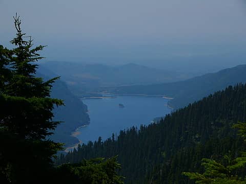 Tolt Watershed
|
| Back to top |
|
|
Slugman
Its a Slugfest!

Joined: 27 Mar 2003
Posts: 16874 | TRs | Pics
|
|
Slugman
Its a Slugfest!
|
Fri Mar 05, 2010 5:46 pm |
|
|
What money are they spending keeping people out? You say "sizable sums", which sounds as if you know what the sums are. It seems like there would be more money spent allowing people in. And personally, I don't want people going to the bathroom near or in my drinking water source, or using motorized watercraft on it. In some other parts of the country they are also doing more water treatments and chlorine etc. That would cost money if we had to do more of it here.
I don't like your use of the word "paranoia" which implies that you are knowledgeable on this subject, and have evidence that the restrictions are unnecessary. You obviously have an agenda and an ax to grind, rather than seeking knowledge as you make token effort to convince us of in your second "question". I'd also like to see some evidence of your assertion that "people water ski daily on the vast majority of public reservoirs in the US". This could I guess be true, but it sounds made-up to me. So let's see your source for this "information", if you don't mind.
PS: people are kept off of "public lands" all the time, and for very good reasons. Or maybe you think people should be allowed to walk into the Pentagon any time they want, or maybe take a stroll down the runway at an airport?
People tell me my posts sometimes seem to be somewhat harsh and critical. Maybe so. But in this case I'm responding negatively to your implications that the decisions made around here are stupid, paranoid, tantamount to theft of public money, and hurt the very people they are meant to serve. Yet your thinly-veiled claims seem to be based on your own suppositions and not on any evidence. Therefore I challenge you to prove what you imply or to "take it back", so to speak.
PPS: In Connecticut, I lived near Barkhampstead reservoir, and it was off-limits to the public.
|
| Back to top |
|
|
Conrad
Meadow bagger

Joined: 25 Aug 2006
Posts: 2298 | TRs | Pics
Location: Moscow, ID |
|
Conrad
Meadow bagger
|
Fri Mar 05, 2010 6:25 pm |
|
|
There's a lookout on top of Phelps Ridge (W of Mt Phelps) which should have a grandstand view of the reservoir and was hiker-accessible (the stairs anyway) in the early 90's. I must have seen that view but I honestly can't remember. I parked at the gate on Deep Creek and biked all over that ridge in the early 90's. Don't know what the access is like now.
If you go up there, go E as far as you can to a little lake on the ridge just W of Mt Phelps. A pretty little heather-wrapped lake in the middle of clearcuts.
Sluggo gets very defensive if you seem to criticize the NW. Next he'll invite you to leave and shut the door on your way out. 
|
| Back to top |
|
|
Scrooge
Famous Grouse

Joined: 16 Dec 2001
Posts: 6966 | TRs | Pics
Location: wishful thinking |
|
Scrooge
Famous Grouse
|
Fri Mar 05, 2010 6:30 pm |
|
|
Having a bad day, Slug?  That's a little more over the top than usual.
........................................
Ryan, there is, or used to be, a good road along the top of Phelps Ridge. Although the road ran slightly south of the crest, there were any number of spurs that led to good views of the Tolt Reservoir.
Used to be, I had maps of the route on file, because the hike up to Mt Phelps was a personal favorite (and I had a Weyerhaeuser pass).
Unfortunately, everybody's favorite State agency, DNR, did a land swap for a chunk of land around Mt Phelps ......... and immediately proceeded to grind up (decommission) the last three miles of road. That's a little more over the top than usual.
........................................
Ryan, there is, or used to be, a good road along the top of Phelps Ridge. Although the road ran slightly south of the crest, there were any number of spurs that led to good views of the Tolt Reservoir.
Used to be, I had maps of the route on file, because the hike up to Mt Phelps was a personal favorite (and I had a Weyerhaeuser pass).
Unfortunately, everybody's favorite State agency, DNR, did a land swap for a chunk of land around Mt Phelps ......... and immediately proceeded to grind up (decommission) the last three miles of road.  Then Hancock took over, upped the entrance fee beyond my means .......... and I decided to free up some file space (by deleting "useless" maps).
However, if you're actually interested in going there, I'll be glad to do a new route map and send it to you (or post it here, just in case anybody else is interested).
Then Hancock took over, upped the entrance fee beyond my means .......... and I decided to free up some file space (by deleting "useless" maps).
However, if you're actually interested in going there, I'll be glad to do a new route map and send it to you (or post it here, just in case anybody else is interested). 
Something lost behind the ranges. Lost and waiting for you....... Go and find it. Go!
Something lost behind the ranges. Lost and waiting for you....... Go and find it. Go!
|
| Back to top |
|
|
RyanBiggs
Member
Joined: 05 Mar 2010
Posts: 8 | TRs | Pics
|
Excellent tips, thanks much folks! I'm impressed by the quick display of area knowledge. I enjoy the photo especially.
Scrooge - since I haven't explored around that area: is this an area where you have to drive in miles and miles through Hancock land in order to get to even get near Phelps ridge, or can you drive fairly close until you hit a gate and then mountain bike a reasonable distance from there?
Red mountain seems like a cool place to explore, but I think the road to the Crater Lake area is washed out...  To respond briefly-ish to the criticism, yes I knew I was opening myself up to being accused of being a NW hater, and I knew I'd hear the "we don't let people onto military reservations" comparison but come on, this isn't the Hanford site, it's a lake people. Perhaps it's obvious that I (a) relocated here from another part of the country and (b) don't hesitate to share an opinion, but I certainly love the area even if I find some of the local customs a bit odd!
As to the specifics, I won't belabor the point because I make no claims to be an expert and wouldn't swear that all of my impressions are strictly true. I don't know what the security budget is, but I do know there is one. I just certainly know that I used to water ski on our local reservoir where I used to live, visited many other public mixed use ones in various states, and never heard of such a thing as a no trespassing public reservoir until I moved here. (See, briefly, http://en.wikipedia.org/wiki/Reservoir#Recreation) I believe I saw on a Seattle Public Utilities site that Seattle is one of only 2 major metro areas in the US with such a system, could be mistaken. Spada Lake, Everett's reservoir, is open to the public, for example. So I still wonder WHY, other than the fact that people scream when someone suggests there is another way! 'Nuf said.
To respond briefly-ish to the criticism, yes I knew I was opening myself up to being accused of being a NW hater, and I knew I'd hear the "we don't let people onto military reservations" comparison but come on, this isn't the Hanford site, it's a lake people. Perhaps it's obvious that I (a) relocated here from another part of the country and (b) don't hesitate to share an opinion, but I certainly love the area even if I find some of the local customs a bit odd!
As to the specifics, I won't belabor the point because I make no claims to be an expert and wouldn't swear that all of my impressions are strictly true. I don't know what the security budget is, but I do know there is one. I just certainly know that I used to water ski on our local reservoir where I used to live, visited many other public mixed use ones in various states, and never heard of such a thing as a no trespassing public reservoir until I moved here. (See, briefly, http://en.wikipedia.org/wiki/Reservoir#Recreation) I believe I saw on a Seattle Public Utilities site that Seattle is one of only 2 major metro areas in the US with such a system, could be mistaken. Spada Lake, Everett's reservoir, is open to the public, for example. So I still wonder WHY, other than the fact that people scream when someone suggests there is another way! 'Nuf said.
|
| Back to top |
|
|
Scrooge
Famous Grouse

Joined: 16 Dec 2001
Posts: 6966 | TRs | Pics
Location: wishful thinking |
|
Scrooge
Famous Grouse
|
Fri Mar 05, 2010 8:54 pm |
|
|
Ryan, the simple answer is that it's a long way, roughly from the gate on Route 2 to the Spur 10 gates, with access to the Tolt Reservoir or Phelps Ridge being about in the middle.
If you have a pass, you can drive to the top of Phelps Ridge, if not ....... it's a long way. ........ But not impossible. I know people who have done it on bikes starting at Spur 10.
Something lost behind the ranges. Lost and waiting for you....... Go and find it. Go!
Something lost behind the ranges. Lost and waiting for you....... Go and find it. Go!
|
| Back to top |
|
|
RyanBiggs
Member
Joined: 05 Mar 2010
Posts: 8 | TRs | Pics
|
Thanks Scrooge, I recently found out those Hancock passes exist and might consider getting one to explore around if I lived off I-90 instead of US 2, but yeah I understand they are pretty pricey. A lot of money for just one gotta-do-it silly trip. I guess I'm glad there is a way to gain driving access into Hancock land at all.
It does seem doable from the Spur 10 gate on a bike but yeah pretty long. Unfortunately, access to the north side Hancock gate is via FR 62 through Longview Fibre land, which was open to public motorized access until last summer when they felt compelled to gate it due to it getting too trashed out and abused. I might yet attempt it from the north some long summer day - It takes about 2 1/2 hours to bike from US 2 to the base of Mt. Lee, and then probably a good while to make it up to the ridge line from there. Total effort either way seems like it would be fairly similar. Camping would make it easier, but of course they don't want that.
The Red Mountain option seems the most attractive and would probably be the most accessible except for the washout on FR 6420 - actually the portion that is a county road (Money Creek Road) apparently. Unfortunately it seems the chances of this road being repaired any time soon probably aren't too great - the washout is pretty major. It'll likely take someone wanting to cut trees out of there for it ever to be repaired, and for that to actually be economical, which is good for the trees at least!
Also in my unhealthy fascination with area land use category: my maps indicate some of the land (especially between US2 and the Tolt) claimed by Longview and Hancock is NFS land. I wonder if anyone knows if these companies have a lease on the land, or did it become privately owned at some point? Just curious, damned if I know why I am!
|
| Back to top |
|
|
Scrooge
Famous Grouse
Joined: 16 Dec 2001
Posts: 6966 | TRs | Pics
Location: wishful thinking |
|
Scrooge
Famous Grouse
|
Sat Mar 06, 2010 4:46 am |
|
|
RyanBiggs said | Quote: | | Also in my unhealthy fascination with area land use category: my maps indicate some of the land (especially between US2 and the Tolt) claimed by Longview and Hancock is NFS land. I wonder if anyone knows if these companies have a lease on the land, or did it become privately owned at some point? Just curious, damned if I know why I am! |
Hey, Ryan, it's all right. Your interest just shows you've come to the right place; you belong here.  As you'll discover after you've been around awhile, most of us are not just here as hikers, as users of the land. A lot of our concerns and our conversations revolve around how the land is managed and who manages it. Our free lives revolve around the land.
In the case you're talking about, there's no conflict. National Forests are the "Land of many uses". Land within the boundaries of a National Forest may be owned outright by private companies or individuals, it may be leased to the same entities for use, it may be ceded very lightly under the terms of things like "grazing rights" (for very modest fees), or it may be wholly managed by the NFS, either because nobody wants to use it or because we've (the government's) decided we want it withheld from any private use or development, as in Wildernesses.
All levels of private holding are subject to some elements of regulation and restriction that would not apply if they were outside the National Forest.
Et cetera, et cetera, et cetera.
But the devil is in the details, and you'll find that we devote hundreds of pages to trying to sort out the variations. ........ Enjoy.
As you'll discover after you've been around awhile, most of us are not just here as hikers, as users of the land. A lot of our concerns and our conversations revolve around how the land is managed and who manages it. Our free lives revolve around the land.
In the case you're talking about, there's no conflict. National Forests are the "Land of many uses". Land within the boundaries of a National Forest may be owned outright by private companies or individuals, it may be leased to the same entities for use, it may be ceded very lightly under the terms of things like "grazing rights" (for very modest fees), or it may be wholly managed by the NFS, either because nobody wants to use it or because we've (the government's) decided we want it withheld from any private use or development, as in Wildernesses.
All levels of private holding are subject to some elements of regulation and restriction that would not apply if they were outside the National Forest.
Et cetera, et cetera, et cetera.
But the devil is in the details, and you'll find that we devote hundreds of pages to trying to sort out the variations. ........ Enjoy.
Something lost behind the ranges. Lost and waiting for you....... Go and find it. Go!
Something lost behind the ranges. Lost and waiting for you....... Go and find it. Go!
|
| Back to top |
|
|
Lono
Member

Joined: 19 May 2006
Posts: 930 | TRs | Pics
|
|
Lono
Member
|
Sat Mar 06, 2010 5:55 am |
|
|
OK, I'll generalize: when people came to the Pacfiic Northwest, whether it was 13,000 years ago or 130, they had an abundance of clean, pure water. As the area grew in popularity, folks wanted to preserve that pure water, and such was born the protected watersheds concept, mostly to service the burgeoning Seattle area. In the lower 48, you can make an argument that of any major metropolitan area like Seattle, it has the best water, bar none. I have heard New Yorkers make the same claim for their water, they also have an extensive watershed, although having tried both from the tap I think ours is a little better. Similar clean, pure water systems in places like Missoula and Lander, WYO are being compromised by the search for oil and gas and infiltration into the water table. But what are you gonna do...
If you have a yearning to step onto someone's watershed, just drive south 30 minutes to Lake Tapps. Lake Tapps is a very public watershed, with lakefront homes, fuel and smoke belching recreation, contaminating septic systems, and because of the close proximity to all those people, a regular amount of sludge and pollution that constantly adds to its shores. In a matter of years, folks on the Eastside including Bellevue will start sipping from Lake Tapps, and stop taking water from the protected Cedar River and Tolt watersheds. Bad idea if you ask me. The Califnornicators who came up here and came up with the amazing scheme to transition all those people from clean pure water to reproccessed Lake Tapps stuff will be sipping their bottled water, I honestly don't believe they are stupid enough to drink their own product. Because Lake Tapps and other public sh## hole water is just that, a product, to be sold, regulated, rationed and ultimately hated for its bland flavor, which will be the result of stewing in the mix of sludge and old band aids at the bottom of Lake Tapps. Go now, I think the Lake is still in draw down, you can wander around and see where the water is coming from, its not a pretty sight.
And while we're on the topic of public access, the Cedar River watershed has public access, but its controlled. Go to their website, sign up for one of their tours, they have some really good ones, or especially sign up for one of their work parties where you can go and remove invasive plants and otherwise improve the watershed. Just don't go tromping in there on your lonesome, you aren't welcome for that.
Obviously I am not a hydrologist or a water works engineer, but I can smell a greedy setup when I see one. Its a shame that people will be trading for a worse water supply owing to population growth, but what are you gonna do.
|
| Back to top |
|
|
Schroder
Member

Joined: 26 Oct 2007
Posts: 6747 | TRs | Pics
Location: on the beach |
|
Schroder
Member
|
Sat Mar 06, 2010 7:14 am |
|
|
The battle over public access to watersheds has gone on since they started building them. Tolt was easy to close off because all the surrounding land at the time was private - part of Weyerhaeuser's Snoqualmie tree farm.
When Tacoma built their reservoir on the Green River and put up a gate and forced Lester residents to drive all the way to Stampede Pass they fought all the way to the U.S. Supreme Court and Tacoma won.
The latest is the Sultan Basin watershed. It was allowed to be built with the agreement to provide public access for recreation, which they are now reneging on. The Pilchuck River valley leading out of the area, which provides water to Snohomish, was closed off in 1990 and now they're doing their best to close off Spada & the upper Sultan River.
I agree with RyanBiggs - there's an unnecessary amount of paranoia concerning keeping the public out of there.
Phelps Ridge and Red Mtn are both good vantage points.
|
| Back to top |
|
|
RyanBiggs
Member
Joined: 05 Mar 2010
Posts: 8 | TRs | Pics
|
Ah thanks Scrooge, I just learned something there. I was under the false impression that National Forest lands were inherently publicly owned - I didn't realize they could be both private and NFS. I suppose it should have been obvious since of course there are numerous towns and private dwellings on NFS lands but I guess I thought these were either "grandfathered in" or operated under some sort of lease arrangement.
I appreciate the opinions on the watershed issue, which is beginning to help me to understand why things are the way they are. Really it seems to me that it comes down to alternative priorities - one can make a good argument either on the "best protection for resources" basis or on the "allow public access to public lands" basis. My impression is that most of the country has chosen to focus on the latter (partly because of the relative lack of public lands for outdoor recreation in many regions compared to the NW) while public opinion leans towards the former here.
Schroder provides some good information - I was aware of the situation with Lester but wasn't aware of the degree of the court battle involved. I'm a bit disappointed to hear about the Sultan Basin situation, as I've done a fair amount of hiking and such in the area and enjoyed it quite a bit, although it's been obvious that maintaining the trailhead road access is not at all a priority.
Given as I am to compromise solutions, if I was ruler of the world it really seems like a happy medium would be, or at least would have been, possible in each of the cases we've discussed. I wouldn't like to see rampant development or natural resource extraction in watersheds for sure, but I really do continue to feel the "no one must enter or disaster will strike" mentality is a bit, yes, paranoid. But I do recognize this is partly a money issue: Slugman does have a point that public access does cost something in terms of facility upkeep and some degree of enforcement to be sure the resource is protected. Personally, this is a price I'd be willing to pay (one solution: charge an entrance fee!), but everyone-get-off may indeed be cheaper, while rampant development brings in the tax dollars. And, well, we don't really live in a very compromising culture; the battle of absolutes seems to rule the day.
I do intend to do a Cedar River tour some day!
|
| Back to top |
|
|
Lono
Member
Joined: 19 May 2006
Posts: 930 | TRs | Pics
|
|
Lono
Member
|
Sat Mar 06, 2010 10:01 pm |
|
|
No one sees their own path through the woods - we all step so lightly, and leave nothing behind of course. But ten thousand per day or year, a trail sets in, garbage accumulates, and you should notice a bigger impact. Its an old story, its human nature - just don't pretend it won't happen, it will.
|
| Back to top |
|
|
RyanBiggs
Member
Joined: 05 Mar 2010
Posts: 8 | TRs | Pics
|
Well yes, public access has negatives, no argument. But we are moving into almost an area of moral philosophy here, and moral philosophy always reduces to emotional judgments of which values are most important. Putting up a fence and telling people to go away has negatives too. Namely, it reduces our enjoyment and in many cases appreciation of the land. And my whole interest in this topic is because the thing we call the "watershed" is not an appliance to me, it's a beautiful piece of the planet we all share.
It just strikes me that many communities have struck balanced approaches that appear to work ok and don't unacceptably compromise public safety. Obviously the majority of Seattleites support the absolutist approach, and that's fine. I'd rather see this than some of the nightmare opposite extreme scenarios described. I just think it is clear there are alternative approaches which are both cogent and prevalent in other areas. Perhaps in this region, for whatever reasons, we only seem to have the two extremes.
I'm not trying to argue here that people shouldn't support the status quo or feel that it is best, I'm mainly just trying to understand why people here feel this way when people other places feel differently. Some of the comments here on both sides have shone some light on this, and that's what I was hoping for, not to start a battle. This is a hiking forum and probably not the right place for a political debate - the only link is that someone telling me I can't go somewhere makes me personally want to go on a hike to check it out!
Ultimately I think it comes down to the fact that Seattle is in a geographical region in which local society can afford a single use area, the no trespassing policy is best suited to this single use, and there have been historical factors which have led city leaders to these conclusions. It's good that people support and agree with these conclusions, but I do find the attitude that there is no other reasonable approach unreasonably combative.
|
| Back to top |
|
|
timo78
Member
Joined: 07 Mar 2010
Posts: 1 | TRs | Pics
|
|
timo78
Member
|
Sun Mar 07, 2010 1:47 am |
|
|
I agree with the OP. Last year hiking a back way into chester morse; just wanting to see some undiscovered country around Hobart. This is miles! from the lake itself, but in the watershed. I know there's a little lake just beyond a gate that clearly states its illegal to trespass etc. I cross it. The old growth stumps are impressive back there. No less than 30mins later a truck pulls up behind me. The 'ranger' was cool but stated he generally 'arrests' people for this infraction. Arrested for hiking? He didn't, so the dog and I walked out.
I've been in the Stillwater area recently and the amount of gates bugs me. It sucks that 1% of the people in the woods ruin it for all us by shooting TV's and dumping garbage/crap etc out there so they gate EVERYTHING and leave no parking for walkins either. 
|
| Back to top |
|
|
|
|
You cannot post new topics in this forum
You cannot reply to topics in this forum
You cannot edit your posts in this forum
You cannot delete your posts in this forum
You cannot vote in polls in this forum
|
Disclosure: As an Amazon Associate NWHikers.net earns from qualifying purchases when you use our link(s). |


