| Previous :: Next Topic |
| Author |
Message |
mountaineer ordinaire
Member


Joined: 07 Dec 2007
Posts: 496 | TRs | Pics
|
For various reasons, including a snow-covered road, poor weather, and less than ideal timing, after a month of trying, I finally found a window of opportunity to ski Bean Creek Basin in the Teanaway area.
Unfortunately, two regular ski partners, more forgiving than the average message board responder, were occupied. Having no trip reports to go by other than a single one stating only "the road is open", I apprehensively posted messages on TAY.com and WSTC.org seeking backcountry ski partners.
Early Sunday morning, Paul (a one-time previous ski partner), Jennifer, Beth, and I drove east and were pleased to see patches of blue sky beyond Cle Elum. Given the weather forecast, we expected mostly cloudy skies, cool temps, and, later, afternoon snow flurries. Instead, we arrived at the Beverly Creek trailhead under a clear blue sky with temps in the upper 40's. My primary route concern -- crossing Bean Creek -- was put to rest once we saw a well-established boot path offering a safe option to cross the creek at its standard point.
The low snowpack required us to stow our skis on our packs for about 1 1/3 miles. With little snow remaining, the two major avalanche chutes which cross the hiking trail posed no danger. Just beyond the second and largest of the two chutes, we began skinning up three to four foot deep consolidated (mostly) corn snow.
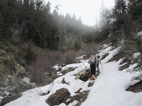 Hiking up Bean Creek trail 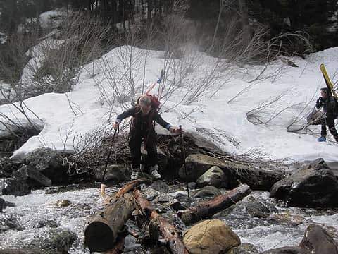 Crossing Bean Creek 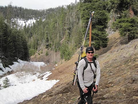 how's that go... 1 lb less on your feet = 6 lbs off your back? 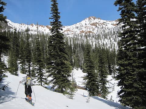 Paul and Bean Peak 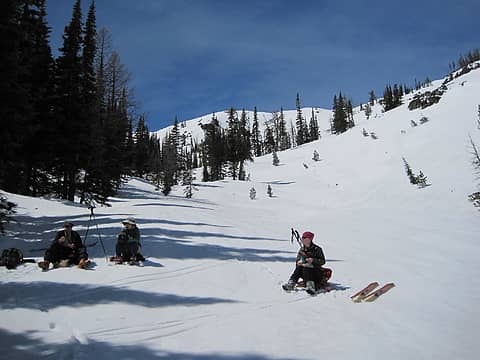 Lunch 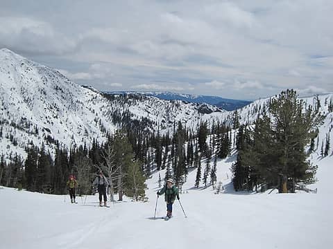 Heading toward the ridge 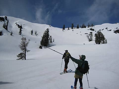 Look, those 3 skiers know what they're doing 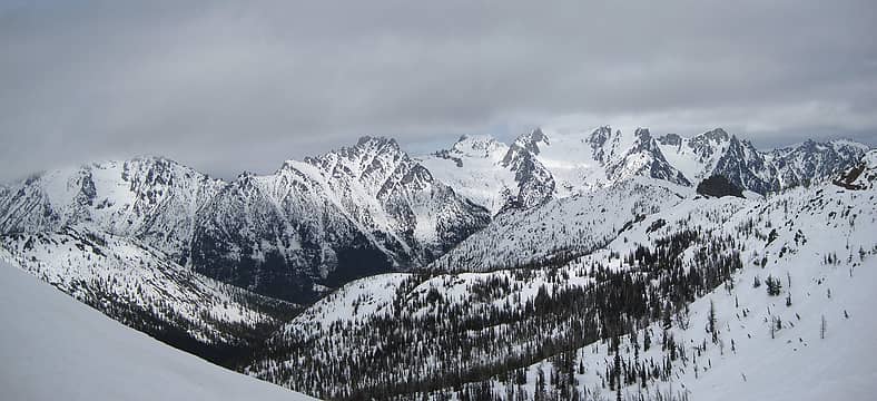 Pano Stuart Range 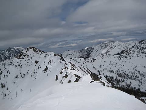 Looking ENE toward Bean, Earl, and Navaho 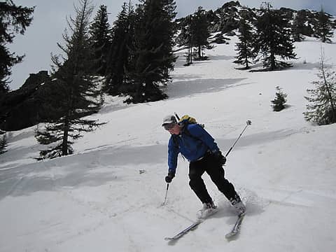 -2 style points: baseball cap + ski googles 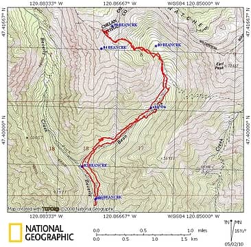 Route
|
| Back to top |
  
|
|
Anna Mae
or may not

Joined: 18 Feb 2004
Posts: 239 | TRs | Pics
Location: vacillating |
|
Anna Mae
or may not
|
 Mon May 03, 2010 9:09 pm |
|
|
Nice report, MO. It's fascinating how different winter recreational activity can be from what you see in ski areas and read about in hiking guides. There's a bunch of people playing out there that most folks don't even suspect.
Anna Mae
Against stupidity ...... the gods themselves ...... contend in vain.
Against stupidity ...... the gods themselves ...... contend in vain.
|
| Back to top |
|
|
puzzlr
Mid Fork Rocks

Joined: 13 Feb 2007
Posts: 7223 | TRs | Pics
Location: Stuck in the middle |
|
puzzlr
Mid Fork Rocks
|
Tue May 04, 2010 1:25 am |
|
|
Can you elaborate on the condition of the North Fork Teanaway road? Could you drive all the way to the Beverly Creek TH? Did the North Fork road look open beyond the Beverly Creek turn-off?
|
| Back to top |
|
|
mountaineer ordinaire
Member
Joined: 07 Dec 2007
Posts: 496 | TRs | Pics
|
We were able to drive the entire way to the Beverly Creek trailhead.
The road is 100% snow free so there's no need for AWD. A few drainages in the road don't require a high clearance vehicle but most sedans would likely bottom out. If you drove this road last year with no problems, these man-made ditches are no more difficult.
According to this 5/2 note: North Fork Rd is snow free for a mile past the Beverly Creek campground.
|
| Back to top |
|
|
joker
seeker

Joined: 12 Aug 2006
Posts: 7953 | TRs | Pics
Location: state of confusion |
|
joker
seeker
|
Wed May 05, 2010 9:55 pm |
|
|
Nice job. That's a fun tour. Earl is a great ski as well, with multiple worthy lines, though overall a tad steeper and a teeny bit more complex to get to the top of. I always love seeing the avalanche lillies and such on the hike back out at the end of the day too. Ski crampons are a wonderful thing in the spring, eh? (I think I see some in one of the photos...)
It's also amazing how quickly this tour tends to melt out. Might be OK this weekend still, though, given this week's cool wet weather, but I've seen one week make a massive difference.
|
| Back to top |
|
|
mountaineer ordinaire
Member
Joined: 07 Dec 2007
Posts: 496 | TRs | Pics
|
| joker wrote: | | Earl is a great ski as well |
I remember well your May 2009 Earl Peak ski tour because it motivated me -- a novice backcountry skier and Teanaway area aficionado -- to get out to that area this season.  Maybe next season, to put my ski crampons to even better use, I'll have improved enough to graduate from Bean Creek Basin to Earl Peak. Maybe next season, to put my ski crampons to even better use, I'll have improved enough to graduate from Bean Creek Basin to Earl Peak. 
|
| Back to top |
|
|
Layback
Cascades Expatriate
Joined: 16 Mar 2007
Posts: 5712 | TRs | Pics
Location: Back East |
|
Layback
Cascades Expatriate
|
Sat May 08, 2010 8:01 am |
|
|
Nice job MO.
|
| Back to top |
|
|
joker
seeker
Joined: 12 Aug 2006
Posts: 7953 | TRs | Pics
Location: state of confusion |
|
joker
seeker
|
Sat May 08, 2010 8:51 am |
|
|
| mountaineer ordinaire wrote: | | joker wrote: | | Earl is a great ski as well |
I remember well your May 2009 Earl Peak ski tour because it motivated me -- a novice backcountry skier and Teanaway area aficionado -- to get out to that area this season. Maybe next season, to put my ski crampons to even better use, I'll have improved enough to graduate from Bean Creek Basin to Earl Peak. |
Cool. I hope the area lived up to your expectations! And thanks for the evidence for a premise I've noted a few times on the site, sometimes to slight controversy, that TRs do prompt more people to head to a destination. In this case, though the 509 area skiers may disagree, I feel fine about having more folks up there in the Basin during the brief spring ski window. The first time we went up there, back in about '96, and doing much the same route you appeared to do (a nice route for sure!), we saw only one other party, some folks from near Cle Ellum or Ellensburg who were quite stunned to see another party up there, especially westsiders. Apparently the 100 XC ski tours book was not drawing that many folks over. I'm pretty sure some TAY and nwhikers TRs have managed to do what the book did not, perhaps in part by providing key timing info on when the road is open and the snow cover is still good...
As for Earl, one thing I'll note is that on our first trip up, we reached a point on the ridge that we climed (the one going from Earl over to Bean etc.) where we looked up toward Earl and thought "this is not going to go!" But we followed a basic mountain rule of "just keep going until we're shut out" and a half hour or so later, found ourselves on the north tip of the summit ridge. It almost always looks worse looking up at a route than actually being on it. But in any case, the basin is a great area in that it holds fun skiing for a pretty wide range of skill levels, and carrying your skis and the creek crossing are the only minor defenses placed in front of that skiing (perhaps about a fifth of the time, we've needed to wade it - I've taken my boot liners out and waded in my shells, which is a slightly painful move but works...).
|
| Back to top |
|
|
mountaineer ordinaire
Member
Joined: 07 Dec 2007
Posts: 496 | TRs | Pics
|
| joker wrote: | | And thanks for the evidence for a premise I've noted a few times on the site, sometimes to slight controversy, that TRs do prompt more people to head to a destination. |
I'm sure you're aware, if anyone is guilty of drawing more skiers to Bean Creek Basin you're a mere accomplice to Tom Kirkendall and Vicky Spring who long ago published Cross Country Ski Tours.  Next season, if you're up for a repeat, let's figure out a time to hit Earl together. Having hiked it several times, I'm eager to experience its intermediate ski tour route.
|
| Back to top |
|
|
Mtn Man
Snow addict

Joined: 13 Jan 2008
Posts: 552 | TRs | Pics
Location: Shoreline, WA |
|
Mtn Man
Snow addict
|
Sun May 09, 2010 12:20 pm |
|
|
Nice TR! We were talking about doing this one last week. Looks like we may need to revisit that discussion!
B)
|
| Back to top |
|
|
joker
seeker
Joined: 12 Aug 2006
Posts: 7953 | TRs | Pics
Location: state of confusion |
|
joker
seeker
|
Sun May 09, 2010 9:43 pm |
|
|
| mountaineer ordinaire wrote: | | I'm sure you're aware, if anyone is guilty of drawing more skiers to Bean Creek Basin you're a mere accomplice to Tom Kirkendall and Vicky Spring who long ago published Cross Country Ski Tours.
|
Indeed. It's where I learned of the tour. Yet the tour seemed to get a noticeable chunk busier in the last 5-8 years, after getting play on turns-all-year a few seasons in a row. I've noticed this with a few other tours too. As I noted above, I think the jungle drums beating out the news that the road is clear and cover still good makes the internet perhaps a little more impactful for this tour than for some others where timing is not as big a deal. In this case, I think it's a good thing - gets folks out to one of those "voluntary snowmobile closure" areas which tends to help keep them that way.
As for next season, if conditions and schedule line up, sure let's join forces for Earl.
|
| Back to top |
|
|
|
|
You cannot post new topics in this forum
You cannot reply to topics in this forum
You cannot edit your posts in this forum
You cannot delete your posts in this forum
You cannot vote in polls in this forum
|
Disclosure: As an Amazon Associate NWHikers.net earns from qualifying purchases when you use our link(s). |


