| Previous :: Next Topic |
| Author |
Message |
Gimpilator
infinity/21M


Joined: 12 Oct 2006
Posts: 1684 | TRs | Pics
Location: Edmonds, WA |
Have you seen Part 1?
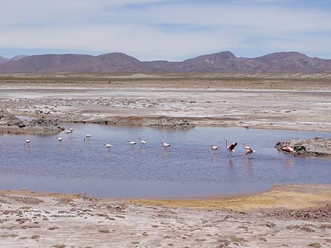
After the salar we drove southwest toward a very remote region near the border of Chile on the edge of the Atacama Desert. We passed one small pond where a flock of flamingos was eating something underneath the salty water. We found this new region was densely full of large volcanoes. They ranged from 16,000 to 20,000 feet and were spaced only five or ten miles apart from each other. One could really spend years climbing in this country. We were looking for a specific road. It wasn't on any maps but Rob had done and impressive bit of research using Google Earth and he was convinced that it would allow us the access we needed for the next climb. After some exciting uncertainty we found the turn off and drove up the rough side-track. The road was highly overgrown with scrubby bushes and grass. I wondered how the hell Rob had spotted it with the satellite imagery. The drivers didn't like it and tried to stop at one point but we convinced them to go a little further. We made camp at 15,300 feet among tufts of grass which I nick-named "cactus grass" because it was sharp and the tips of the grass would come off and stick in you if you brushed up against them. Our drivers informed us that this road had been made by the people of Uyuni to collect the yareta plant for tinder, which grows plentifully in the area. These plants which look like big blobs of green moss only grow above 10,500 feet have an extremely slow growth rate. In fact, some of the ones I photographed are likely to be thousands of years old. I bent down to examine one and found it to be surprisingly firm to the touch.
 Flamingos 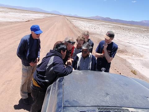 Where The Hell Are We? 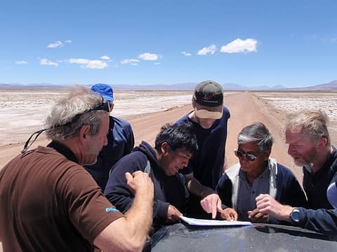 I Think We're Here 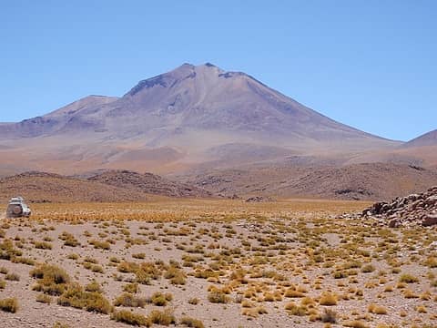 Callejón Cañapa 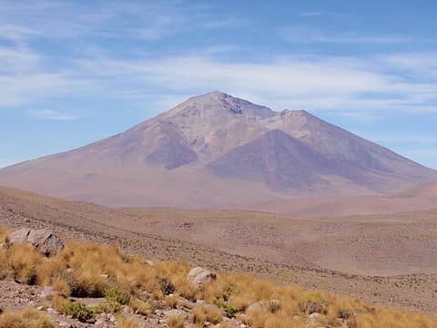 Cerro Tomasamil 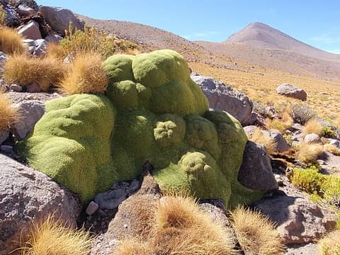 A Mature Yareta Plant 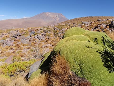 Cerro Caquella and Yareta 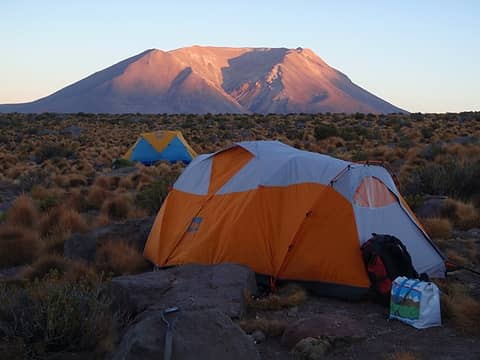 Caquella Alpenglow From Camp 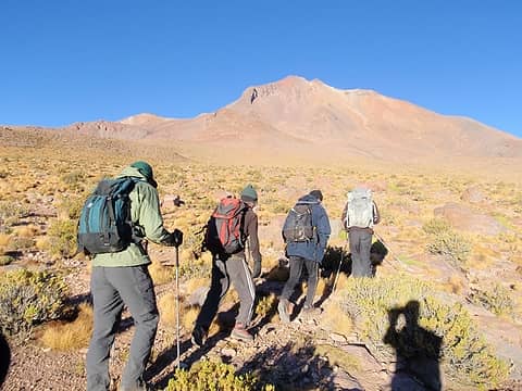 Callejón Cañapa 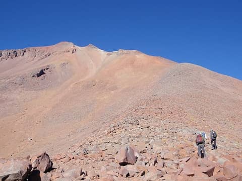 The East Ridge 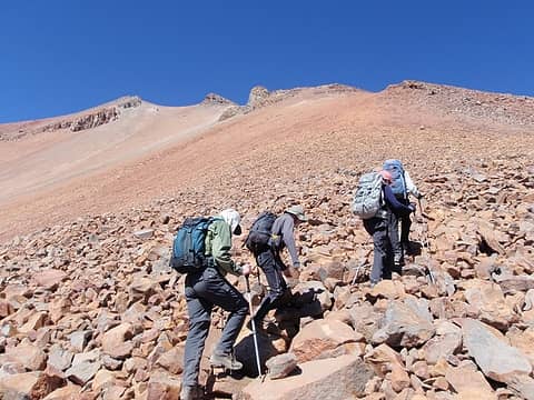 Loose Talus 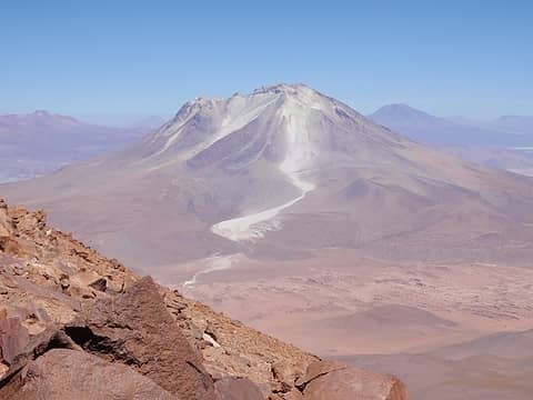 Volcán Ollagüe 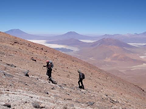 High On Cañapa 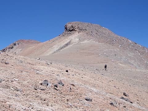 Nearing The Summit  Callejón Cañapa Summit 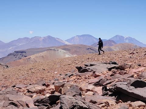 Callejón Cañapa Summit 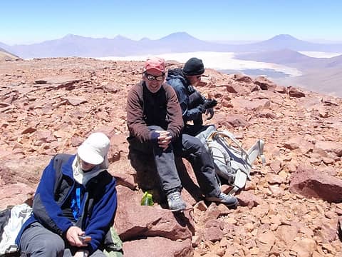 Callejón Cañapa Summit 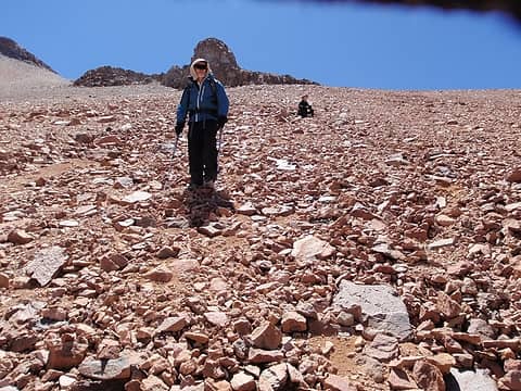 Descending Scree / Talus 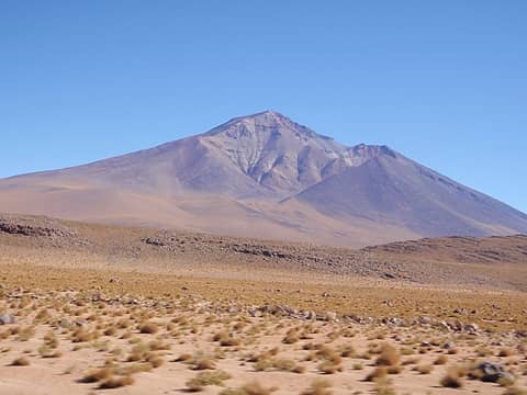 Cerro Tomasamil 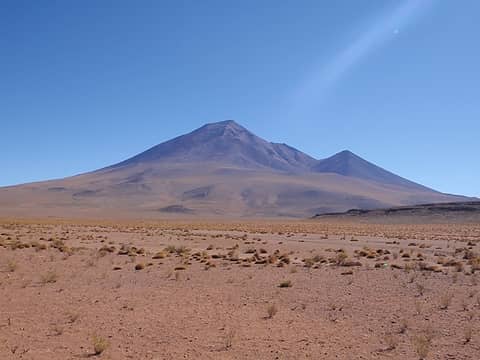 Cerro Tomasamil 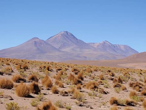 Callejón Cañapa 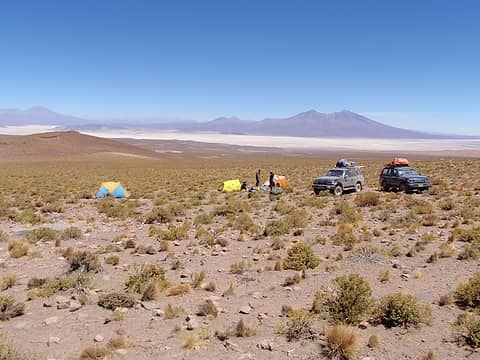 Tomasamil Camp 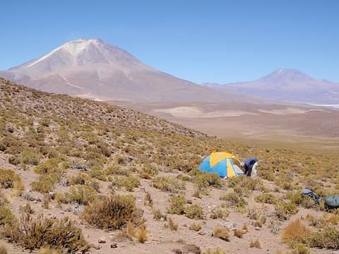 Volcán Ollagüe And Cerro Aucanquilcha 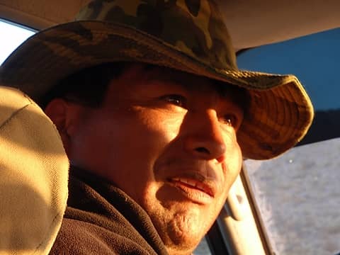 Our Driver, German 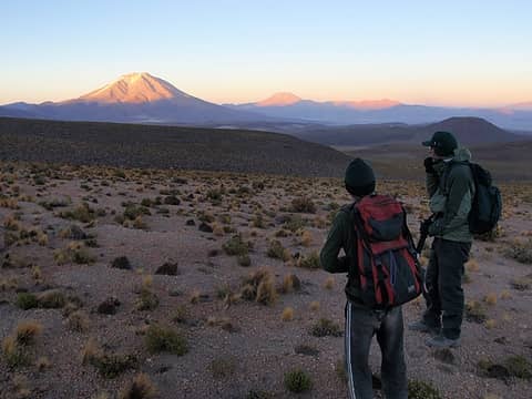 Starting Out 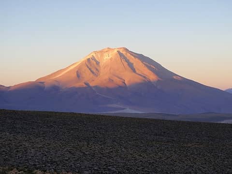 Ollagüe Alpenglow 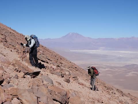 The North Ridge 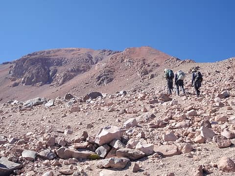 Red Hill Looms Above 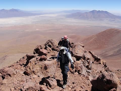 Getting Up There 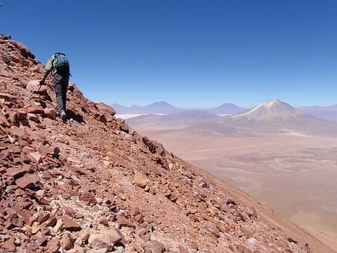 Loose Rock On Red Hill 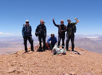 Tamasamil Summit: Duane, Rob, Adam, Petter, Greg 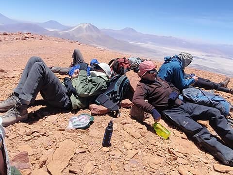 The Catnap 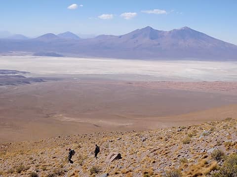 The Descent 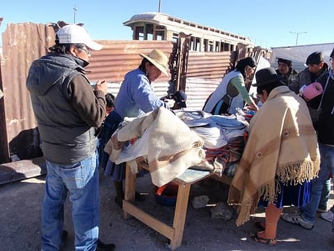 Estación Avaroa 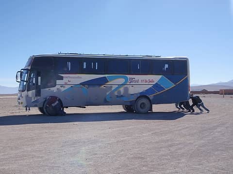 Helping The Bus 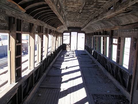 The Old Train Car 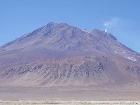 The Vent On Ollagüe
|
| Back to top |
  
|
|
EastKing
Surfing and Hiking

Joined: 28 Mar 2007
Posts: 2082 | TRs | Pics
Location: 77 miles from Seattle! |
|
EastKing
Surfing and Hiking
|
 Mon Jan 31, 2011 8:31 pm |
|
|
Awesome TR! Amazing to be 19000 feet and no glaciers! What an incredible experience. I am so looking forward to the last two TR's
YouTube | SummitPost
Saw the depths of despair. Now I am salvaging what time I have left on Earth.
YouTube | SummitPost
Saw the depths of despair. Now I am salvaging what time I have left on Earth.
|
| Back to top |
|
|
Matt Lemke
High on the Outdoors

Joined: 15 Jul 2010
Posts: 2052 | TRs | Pics
Location: Grand Junction |
|
Matt Lemke
High on the Outdoors
|
Mon Jan 31, 2011 9:56 pm |
|
|
| EastKing wrote: | | Awesome TR! Amazing to be 19000 feet and no glaciers! What an incredible experience. I am so looking forward to the last two TR's |
This is caused by a similar process that occurs in the Colorado Rockies. As the winter storms move in from the west, the Sierra and Cascades get dumped on (sometimes 60-80 feet in the Sierras). Most of the moisture in the systems get sucked out by the coastal ranges and by the time they get to Colorado only a tiny fraction of the original moisture remains. Therefore you can be at 14,000+ feet here in Colorado in the summer and have absolutely no snow.
In South America the process is even more pronounced. The major difference is the fact that systems come from the EAST in the southern hemisphere. Therefore, all the moisture from these storms off the Atlantic drop all their moisture in places like the Amazon and the eastern coast of S America.
So even though the peaks are near 20,000 feet they see even less snow than in the Colorado Rockies (maybe about 3-5 feet per year).
Most of the moisture that falls in these types of mountain ranges come in the form of summer monsoon thunderstorms caused by convection.
Another cool thing...the driest desert in the world is the tiny Atacama Desert located just to the west of some of the high Chilean volcanoes.
Not only is this part of the Andes sheltered in a rain-shadow but this particular small desert is also sheltered by the 20,000 foot peaks just to the east so you can imagine how little moisture gets there.
Definently a part of the world I'm DYING to get to as I'm not really a fan of snow and I can go there while it's winter here and experience a longer continuous summer!!!
BTW...thanks for this awesome set of TR's. Can't wait to see more!
|
| Back to top |
|
|
Redwic
Unlisted Free Agent

Joined: 23 Feb 2009
Posts: 3292 | TRs | Pics
Location: Going to the Prom(inence) |
|
Redwic
Unlisted Free Agent
|
Mon Jan 31, 2011 10:57 pm |
|
|
Awesome again! I cannot wait to read Part III!
I also cannot wait to see how that beard of yours progresses as the trip continues... 
60 pounds lighter but not 60 points brighter.
60 pounds lighter but not 60 points brighter.
|
| Back to top |
|
|
canyonwren
Secret Otter Agent

Joined: 12 Jul 2006
Posts: 362 | TRs | Pics
Location: Snohomish |
|
canyonwren
Secret Otter Agent
|
Tue Feb 01, 2011 12:01 am |
|
|
These are fantastic! Amazing TRs and pics both.
|
| Back to top |
|
|
Eric
Peak Geek

Joined: 21 Oct 2002
Posts: 2062 | TRs | Pics
Location: In Travel Status |
|
Eric
Peak Geek
|
Tue Feb 01, 2011 12:11 am |
|
|
|
| Back to top |
|
|
puzzlr
Mid Fork Rocks

Joined: 13 Feb 2007
Posts: 7220 | TRs | Pics
Location: Stuck in the middle |
|
puzzlr
Mid Fork Rocks
|
Tue Feb 01, 2011 1:50 am |
|
|
Great writing -- thanks for spending the time to write these up. Quite an adventure just to get to these mountains, then more to fight your way up the loose rock. Nice going!
|
| Back to top |
|
|
Cale Hoopes
On Glissade...

Joined: 13 Oct 2009
Posts: 395 | TRs | Pics
Location: Sammamish |
Fantastic report Gimplilator! I loved hiking and climbing in South America...  Looking forward to the next report.... keep it coming. Looking forward to the next report.... keep it coming.
|
| Back to top |
|
|
Go Jo
of the lykkens

Joined: 08 Jun 2003
Posts: 2248 | TRs | Pics
Location: Around The Bend |
|
Go Jo
of the lykkens
|
Tue Feb 01, 2011 1:22 pm |
|
|
|
| Back to top |
|
|
Hikingqueen
Member

Joined: 12 Nov 2007
Posts: 2946 | TRs | Pics
|
WOW is all I can get out 
|
| Back to top |
|
|
Obi Tony Kenobi
Waterfall Crazy!

Joined: 25 Jun 2007
Posts: 1899 | TRs | Pics
Location: Marysville, WA |
Beautiful and I can't stand places that are all brown like a desert! Can't wait to see part 3! 
|
| Back to top |
|
|
marta
wildflower maven

Joined: 07 May 2003
Posts: 1761 | TRs | Pics
|
|
marta
wildflower maven
|
Wed Feb 02, 2011 9:31 pm |
|
|
Truly amazing photos and report. I love the yareta (or llareta as I know it). We spent a couple of days farther north than you in Putre near the Peru/Chile/Boliva border. We drove up into the Nevados de Putre at around 15,500ft and later to Lauca. We found a lot of yareta up there also. I also love the cactus in Part 1.
The altitude was a killer. We haven't made it to Salar yet and your pictures have me salivating to get back there.
|
| Back to top |
|
|
ree
Member

Joined: 29 Jun 2004
Posts: 4399 | TRs | Pics
|
|
ree
Member
|
Wed Feb 02, 2011 10:03 pm |
|
|
Yes, Salar looked incredible. So much to see in South America.
The Atacama Desert is high on my list!
Okay, we're talking about high altitude and sickness... but you mention "pushing through" it. Isn't that dangerous? At what point do you know you're in serious trouble and have to retreat?
Did you make travel arrangements through a guide service? Or did you just hire a driver from the village you started out at?
Sensational pictures! What a great trip. Also love to vicariously enjoy a little sun these days... 
|
| Back to top |
|
|
Gimpilator
infinity/21M
Joined: 12 Oct 2006
Posts: 1684 | TRs | Pics
Location: Edmonds, WA |
Matt Lemke -
Thank for your description of the forces the Atacama. It's the first explanation I've heard about the forces behind the drought.
marta -
The Salar in Uyuni is definitely worth a visit. We heard that there is an island out in the middle of it with a bunch on cactus growing but of course we didn't have time for that.
ree -
Good question about the altitude sickness. There are a wide range of symptoms that one might experience for regular AMS including rapid pulse, fatigue, headache, dizziness, nausea, loss of appetite, and inability to sleep. I have experienced all of those symptoms at various times on other trips so I have a pretty good gauge as to how I'm doing.
As you probably know, altitude sickness can be a precursor to the more serious edemas so it's not something to take lightly. Fatigue, rapid pulse and headaches are fairly common for someone who is adjusting but extreme nausea and vomiting on the other hand are probably a sign that someone has pushed it too far. The two headaches I experienced on the trip were not a positive sign but I knew that we would only be spending a short time at that level. It would not be a good idea to stay at the level where your body is struggling. For instance, if the headaches had occurred at one of our camping locations, It would have been necessary for me to drive down to a lower location.
As far as guides go, we didn't hire any. We found our drivers through a travel agent in La Paz call Topas Travel. I would recommend their services for anyone planning a trip like this because our driver German was excellent and his Land Rover was very nice.
|
| Back to top |
|
|
Magellan
Brutally Handsome

Joined: 26 Jul 2006
Posts: 13116 | TRs | Pics
Location: Inexorable descent |
|
Magellan
Brutally Handsome
|
Sat Feb 05, 2011 4:48 pm |
|
|
More good stuff Gimpy. 
|
| Back to top |
|
|
|
|
You cannot post new topics in this forum
You cannot reply to topics in this forum
You cannot edit your posts in this forum
You cannot delete your posts in this forum
You cannot vote in polls in this forum
|
Disclosure: As an Amazon Associate NWHikers.net earns from qualifying purchases when you use our link(s). |


