| Previous :: Next Topic |
| Author |
Message |
Eaglecadd
Member


Joined: 05 Feb 2010
Posts: 185 | TRs | Pics
Location: Kailua Kona, HI |
OK, time is getting close now for our group to head back out into my favorite place in the Olympics, the Bailey Range. Just wondering if anyone has been out there recently? I am hoping to get snowpack and water availability info. Also I would love to see some recent pics of the area. What shape is the Snowfinger in? Any other comments are welcomed.
Dave
|
| Back to top |
  
|
|
Tomlike
Member

Joined: 22 Jun 2010
Posts: 407 | TRs | Pics
|
|
Tomlike
Member
|
 Wed Jul 17, 2019 10:54 am |
|
|
Based on recent Sentinel imagery, the Snow Finger should probably be referred to now as the Snowless Finger. Aside from the big Snow Hump my guess is that it's pretty dicey/non-existent
|
| Back to top |
|
|
JonnyQuest
Member

Joined: 10 Dec 2013
Posts: 593 | TRs | Pics
|
| Tomlike wrote: | | Based on recent Sentinel imagery, the Snow Finger should probably be referred to now as the Snowless Finger |
That could make things interesting. Maybe the Baileys will become an "out and back". 
|
| Back to top |
|
|
Eaglecadd
Member
Joined: 05 Feb 2010
Posts: 185 | TRs | Pics
Location: Kailua Kona, HI |
So sad! I loved the snowfinger. I will always think of it as a complete unit from Dodwell-Rixon to the cairn.
Any other data on water availability along the trail, especially along the West slopes of Mt. Carrie to Stephen?
Also has anyone gone out from upper Queets Basin to Mt Barnes and then down to the bottom of the snow finger to where the cairn is?
|
| Back to top |
|
|
coldrain108
Thundering Herd

Joined: 05 Aug 2010
Posts: 1858 | TRs | Pics
Location: somewhere over the rainbow |
| JonnyQuest wrote: | | Maybe the Baileys will become an "out and back". |
or do like the couple I ran into last year - a big loop starting and ending at the Hoh Parking lot. They did it counter-clockwise and had to cross the steep gullies at the end where several other groups turned back(their beginning) - puts the catwalk at the very end of the adventure.
Since I have no expectations of forgiveness, I don't do it in the first place. That loop hole needs to be closed to everyone.
Since I have no expectations of forgiveness, I don't do it in the first place. That loop hole needs to be closed to everyone.
|
| Back to top |
|
|
Jake Robinson
Member
Joined: 02 Aug 2016
Posts: 521 | TRs | Pics
|
Hi Eaglecadd,
I hiked to the summit of Mt. Carrie on July 4 but didn't make it any farther than that. On my route, there was zero water past Heart Lake, with the exception of one or two nasty looking puddles on the ridge. Nothing on the west slopes of Carrie, at least in the route to the summit. Only one snow patch near the summit that was easily avoidable. Here are some pics, hopefully they are at least somewhat useful.
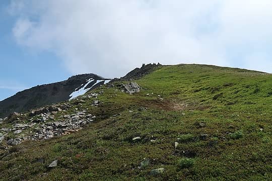 Meadows leading to Carrie 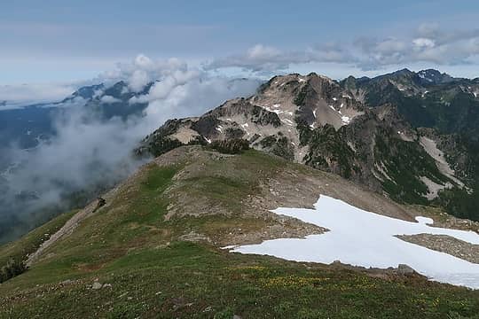 Looking towards Cat Peak from Carrie 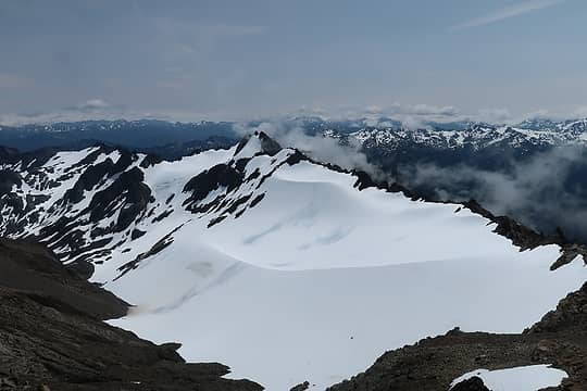 Fairchild Glacier from Carrie summit 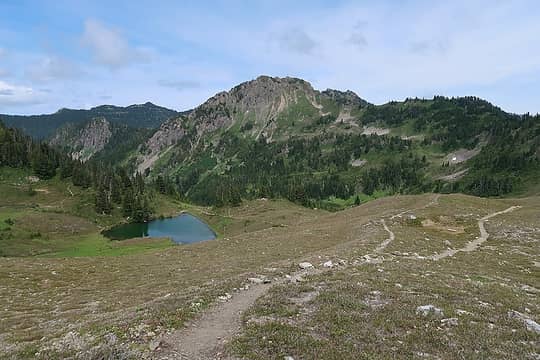 Heart Lake
|
| Back to top |
|
|
Silas
Member
Joined: 14 Aug 2012
Posts: 77 | TRs | Pics
|
|
Silas
Member
|
Wed Jul 17, 2019 3:48 pm |
|
|
We did the traverse last year during the 2nd week of August, so maybe the snow level is similar to this July. The Snow Finger wasn't too bad, just a bunch of gaps and walking in the creek. Lots of water over the whole route. Shouldn't be a problem unless you have a hormone imbalance that makes you drink a lot of water. In hindsight, we probably would have left the ice axes at home and just used our poles to save on the weight.
|
| Back to top |
|
|
JonnyQuest
Member
Joined: 10 Dec 2013
Posts: 593 | TRs | Pics
|
| Eaglecadd wrote: | | Any other data on water availability along the trail, especially along the West slopes of Mt. Carrie to Stephen? |
I've done the Bailey's a few times late summer and early fall (so "low season" for water). Boston Charlie's just after the catwalk has always had water if you're OK with filtering / drinking stagnant water. I've seen a ranger here scoff at us filtering and just drink from that cesspool. I've also always found clean, running water at the far end of the Carrie traverse at that little pseudo campsite just before the path heads uphill in prep for the short traverse then descent into Cream Lake basin. I think Woods calls this pseudo camp Eleven Bull Basin. It's also a spot you can head uphill through the rocks and meadows to the ridge to traverse the back side of Stephan. In my late summer / early fall trips there's never been water at the actual "camp". But if you listen carefully you'll likely hear the sound of trickling water coming from down the hill. If you work your way downhill through the brush and if I remember correctly, slightly to the right, you'll come out into a sloped meadow with a tiny stream trickling out from underground. Just follow your ears. This has always been a reliable water source, even during the dry season. If I remember correctly, there's usually always a handful of tiny streamlets partway across the Carrie traverse at what some people call "the Hall of the Mountain King", another area that is sometimes used for camping.
|
| Back to top |
|
|
Eaglecadd
Member
Joined: 05 Feb 2010
Posts: 185 | TRs | Pics
Location: Kailua Kona, HI |
Thanks a lot for the water info. Last time I went into the Baileys, most of our filters got clogged at Boston Charlies. I have also found water at the ridge overlooking Stephen Lake, but also found it dry at other times. I have never gone the Cream Lake route.I am not a fan of mosquitoes so I have preferred to go over to Stephen Lake and then along the East side of Stephen Peak. I know there will be water at Stephen Lake albeit milky. I was really hoping to have a bit of snowmelt in the gullies along Carrie.
On another note, is there a reasonable route along Carrie ridge from Catwalk to get to Stephen Lake. I really don't like the gullies.
|
| Back to top |
|
|
RAW-dad
Member

Joined: 07 Jul 2017
Posts: 119 | TRs | Pics
Location: Oregon |
|
RAW-dad
Member
|
Wed Jul 17, 2019 5:28 pm |
|
|
Having just returned from the SE Olympics (LaCrosse Basin), I'd say we are about a month ahead in terms of melt, water, etc. That said, I camped in 11 Bull Basin in 2017 (see my TR: mega Bailey Range Traverse, 7-15 Aug) on Aug 10 and there was ample water at several spots below Carrie. Many years back (1995) I stayed at 11 Bull in early Sept and had water. I cannot imagine the stream at 11 Bull being dry anytime soon...
Good luck! Looking forward to the TR and don't let those gullies bother you!
|
| Back to top |
|
|
gb
Member
Joined: 01 Jul 2010
Posts: 6311 | TRs | Pics
|
|
gb
Member
|
Wed Jul 17, 2019 5:41 pm |
|
|
Back in 1994 I did the Bailey in late September and it didn't look like the snow finger would be very safe. So, I walked out the ridge beyond Mt. Barnes and followed game trails towards Chicago Camp. The first 2/3 were very easy, in the final thousand feet the huckleberry brush was about waist high and I had to climb over maybe something like a dozen logs. I doubt that route took over and hour or two.
|
| Back to top |
|
|
Pyrites
Member
Joined: 16 Sep 2014
Posts: 1884 | TRs | Pics
Location: South Sound |
|
Pyrites
Member
|
Thu Jul 18, 2019 12:46 am |
|
|
Snowfinger. You can bushwhack down the left side of the hill. End up a little up the trail from Chicago Camp. Cut up the hill from the gulch early. If you go so far down you see the Big Hump your too far. Youd need to go back up the gulch a half hour to find somewhere to climb out.
Is it easier to just head away from the Snowfinger gulch earlier from Dodwell Rixon?
Best.
Keep Calm and Carry On?
Heck No.
Stay Excited and Get Outside!
Keep Calm and Carry On?
Heck No.
Stay Excited and Get Outside!
|
| Back to top |
|
|
Fatrick
Member

Joined: 09 Aug 2011
Posts: 27 | TRs | Pics
|
|
Fatrick
Member
|
Thu Jul 18, 2019 4:19 pm |
|
|
2 Weeks Ago
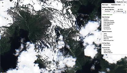 Screen Shot 2019-07-18 at 3.19.49 PM 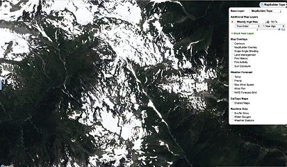 Screen Shot 2019-07-18 at 3.19.03 PM 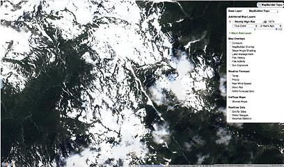 Screen Shot 2019-07-18 at 3.19.23 PM
|
| Back to top |
|
|
Eaglecadd
Member
Joined: 05 Feb 2010
Posts: 185 | TRs | Pics
Location: Kailua Kona, HI |
Thanks for the maps/aerials. I was out there 2 years ago in late August and also in Sept. 2011. As you said, less and less snow each year. Sad. Pretty soon we'll need to go out there in May to see snow. I recall doing a great long glissade down the snowfield to Stephen Lake. I wonder if it is even there now?
|
| Back to top |
|
|
Eaglecadd
Member
Joined: 05 Feb 2010
Posts: 185 | TRs | Pics
Location: Kailua Kona, HI |
|
| Back to top |
|
|
|
|


