| Previous :: Next Topic |
| Author |
Message |
mbravenboer
Member


Joined: 20 Oct 2013
Posts: 1422 | TRs | Pics
Location: Seattle |
I thought Vista Ridge would be a nice fall camp site without people and it didn't disappoint. The trail was in good conditions. On the first Suiattle section there was a handful of blowdowns, but nothing too tricky. The Vista ridge trail has a large number of blowdowns, some large and hard to cross. It used energy and some are a little exposed.
I was surprised to see quite a lot of larch trees on the ridge of Gamma Peak. Water was a bit of a challenge this time of the year. You really need to fill up before you get high.
I also tried to get to Grassy Point but the trail there is mostly non existent. I was a bit tired and decided to not pursue it to the end, expecting some tedious side-hilling.
All photos: https://www.flickr.com/photos/bravenboer/albums/72177720311778117
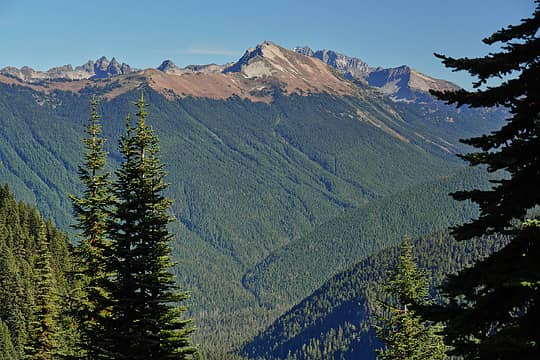 Miners Ridge 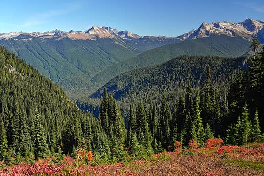 Miners Ridge and Fortress Mountain 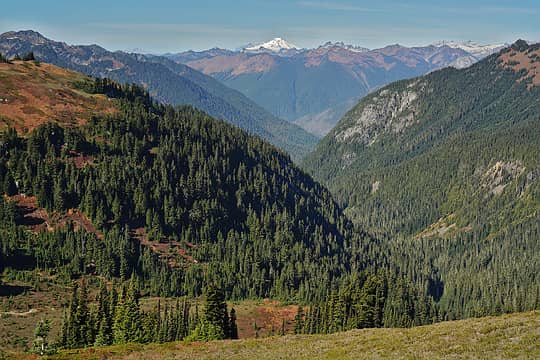 Mt Baker from Vista Ridge 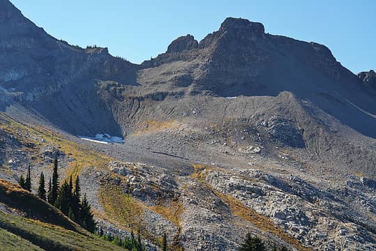 Last bit of old snow at the East Fork Milk headwaters 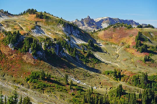 PCT traversing the East Fork Milk drainage 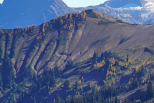 Gamma Ridge 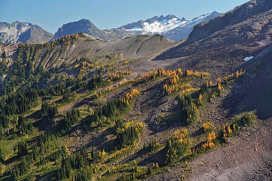 Gamma Ridge from Vista Ridge 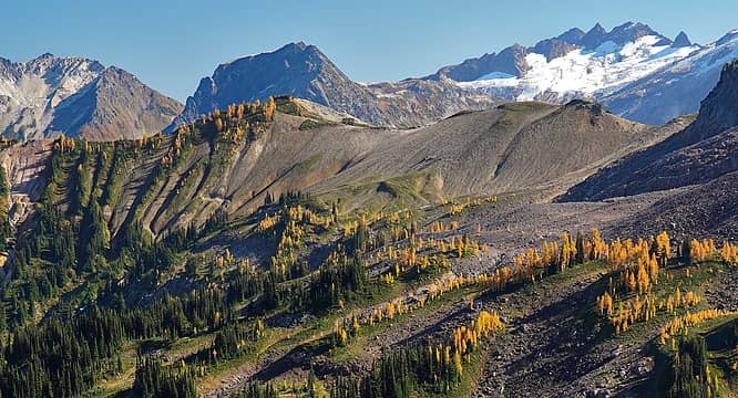 Gamma Ridge, Larches, Butterfly Glacier 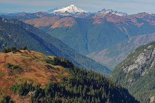 Mt Baker from Vista Ridge 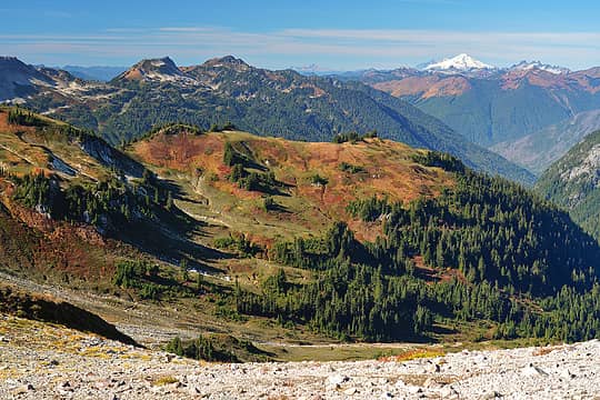 Mt Baker from Vista Ridge 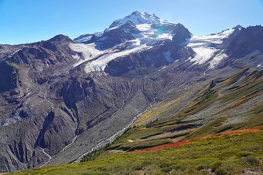 Glacier Peak from Vista Ridge 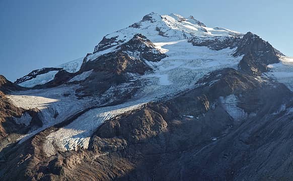 Glacier Peak from Vista Ridge 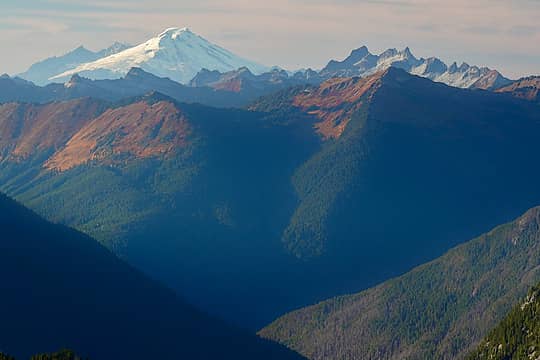 Mt Baker Sunset 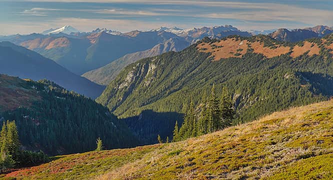 Mt Baker and Grassy Point 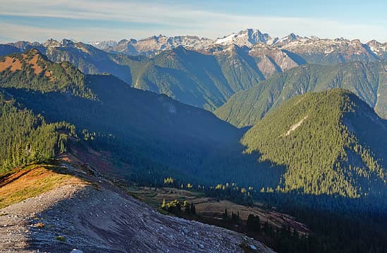 Broad views north from Vista Ridge 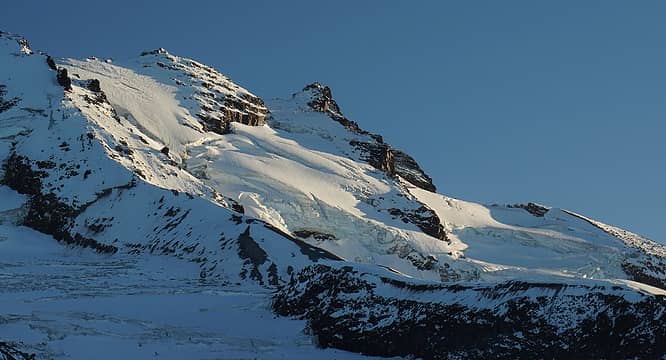 Glacier Peak sunset 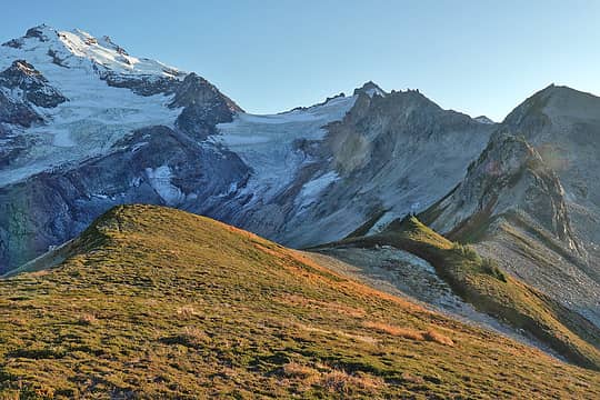 Vista Glacier 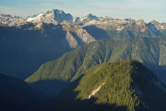 Dome Peak 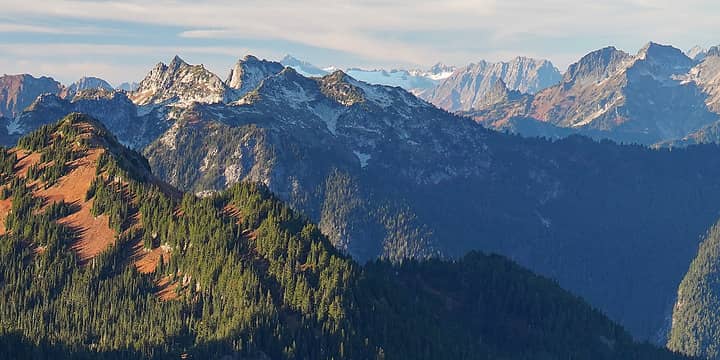 North Cascades views from Vista Ridge 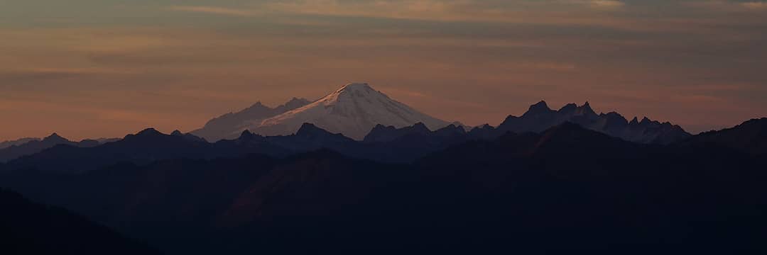 Mt Baker sunset from Vista Ridge 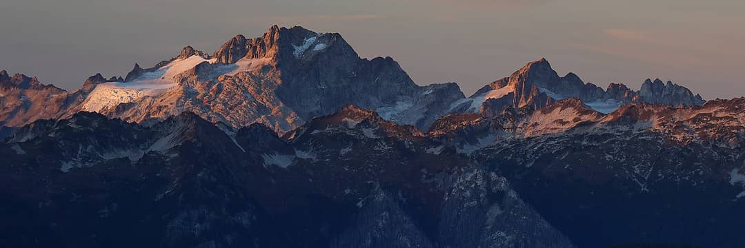 Dome Peak from Vista Ridge 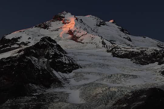 Glacier Peak Sunrise 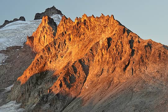 Vista ridge sunrise 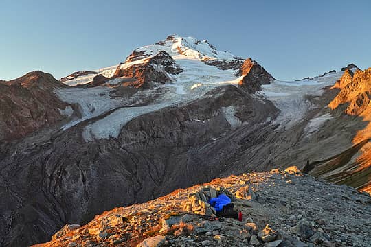 Bivy at Vista Ridge 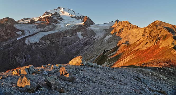 Glacier Peak from Vista Ridge 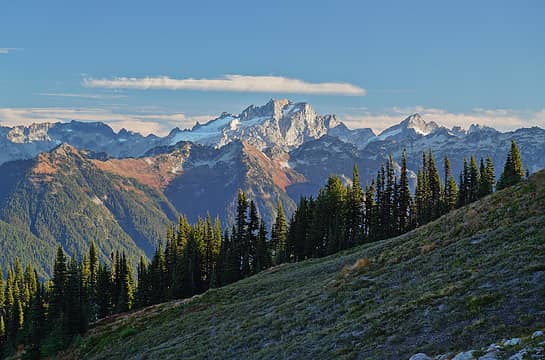 Dome Peak from Vista Ridge 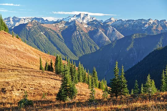 Dome Peak from Grassy Ridge 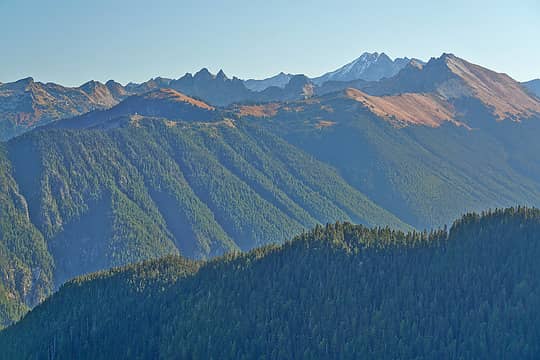 Miners Ridge and Lookout 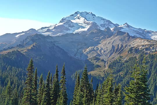 Glacier Peak from Grassy Ridge 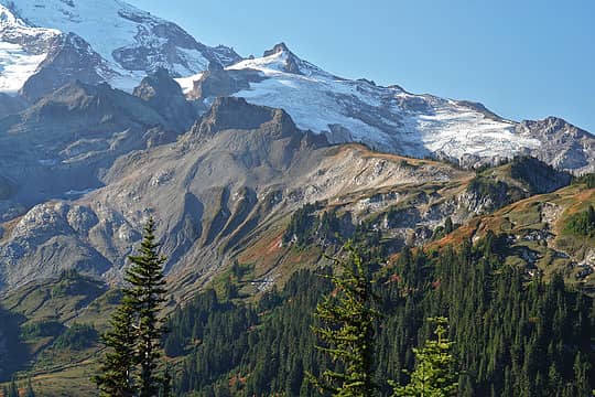 Kennedy Peak and what's left of the Ptarmigan Glacier 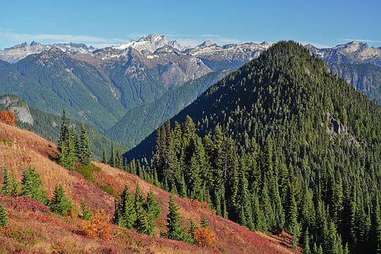 Dome Peak from the PCT just below Vista Ridge 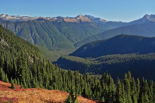 Ridges and trees of the Upper Suiattle River
 Popcorn, Schroder, Michael Lewis, Prosit, YoDutch, fourteen410, neek, lopper, Foist, olderthanIusedtobe, NWtrax, kw, geyer, Nancyann, Kim Brown, MistyMountainHop, contour5, Bowregard, Lightning_bug, jstern, SeanSullivan86, hikerbiker, Malachai Constant, reststep, John Mac, Route Loser, Bramble_Scramble, Waterman, JimK, runup, rubywrangler, raising3hikers Popcorn, Schroder, Michael Lewis, Prosit, YoDutch, fourteen410, neek, lopper, Foist, olderthanIusedtobe, NWtrax, kw, geyer, Nancyann, Kim Brown, MistyMountainHop, contour5, Bowregard, Lightning_bug, jstern, SeanSullivan86, hikerbiker, Malachai Constant, reststep, John Mac, Route Loser, Bramble_Scramble, Waterman, JimK, runup, rubywrangler, raising3hikers  jaysway, awilsondc jaysway, awilsondc  Bushwacker Bushwacker  SpookyKite89, Slim, Anne Elk SpookyKite89, Slim, Anne Elk
Popcorn, Schroder, Michael Lewis, Prosit, YoDutch, fourteen410, neek, lopper, Foist, olderthanIusedtobe, NWtrax, kw, geyer, Nancyann, Kim Brown, MistyMountainHop, contour5, Bowregard, Lightning_bug, jstern, SeanSullivan86, hikerbiker, Malachai Constant, reststep, John Mac, Route Loser, Bramble_Scramble, Waterman, JimK, runup, rubywrangler, raising3hikers jaysway, awilsondc Bushwacker SpookyKite89, Slim, Anne Elk |
| Back to top |
  
|
|
RichP
Member

Joined: 13 Jul 2006
Posts: 5634 | TRs | Pics
Location: here |
|
RichP
Member
|
 Sat Oct 21, 2023 8:51 pm |
|
|
Very nice, Martin. Good to see you posting reports again.  Vista Ridge really lives up to its name. Vista Ridge really lives up to its name.
|
| Back to top |
|
|
Strider518
Member
Joined: 04 Sep 2019
Posts: 19 | TRs | Pics
Location: Bellingham, WA |
Great pictures! May I ask what camera you used?
|
| Back to top |
|
|
zephyr
aka friendly hiker

Joined: 21 Jun 2009
Posts: 3370 | TRs | Pics
Location: West Seattle |
|
zephyr
aka friendly hiker
|
Sun Oct 22, 2023 8:55 am |
|
|
Beautiful work. Nice to see a report from you. ~z
|
| Back to top |
|
|
Kim Brown
Member
Joined: 13 Jul 2009
Posts: 6900 | TRs | Pics
|
Good Lord....
"..living on the east side of the Sierra world be ideal - except for harsher winters and the chance of apocalyptic fires burning the whole area."
Bosterson, NWHiker's marketing expert
"..living on the east side of the Sierra world be ideal - except for harsher winters and the chance of apocalyptic fires burning the whole area."
Bosterson, NWHiker's marketing expert
|
| Back to top |
|
|
Nancyann
Member
Joined: 28 Jul 2013
Posts: 2322 | TRs | Pics
Location: Sultan Basin |
|
Nancyann
Member
|
Sun Oct 22, 2023 9:39 pm |
|
|
Nice to see a trip report from you, Martin. Fantastic pictures! Nice to see those views, three years ago when we were up there everything was obscured by clouds.
Back in the early 70s, the PCT through the East Fork Milk Creek section was still being built and we only had flags to follow. It had snowed and then melted, what a muddy mess it was!
|
| Back to top |
|
|
nickmtn
Member
Joined: 04 Jun 2014
Posts: 105 | TRs | Pics
Location: Kirkland, wa |
|
nickmtn
Member
|
Mon Oct 23, 2023 7:21 am |
|
|
Is anyone else surprised by those larch on Gamma Ridge? Trying to think of another spot where they are west of the crest....
|
| Back to top |
|
|
mbravenboer
Member
Joined: 20 Oct 2013
Posts: 1422 | TRs | Pics
Location: Seattle |
| Strider518 wrote: | | Great pictures! May I ask what camera you used? |
It is a Sony a7R. I normally shoot with a polarizing filter. The crazy resolution is nice for cropping. When I'm really trying to take some good pics I usually plan the location so that the angle with the sun is good. Vista ridge was good for sunset, but for sunrise it was too far in winter already (sun came up too far south).
| Nancyann wrote: | | Nice to see those views, three years ago when we were up there everything was obscured by clouds. |
Maybe it is worth going back! It is shockingly long time in the trees before you see anything though ... Unfortunately to get the Glacier Peak view you have to climb on the ridge, which is somewhat steep heather. There was an established camp site on top though, so I guess it's a known spot.
|
| Back to top |
|
|
Nancyann
Member
Joined: 28 Jul 2013
Posts: 2322 | TRs | Pics
Location: Sultan Basin |
|
Nancyann
Member
|
Mon Oct 23, 2023 10:29 am |
|
|
Good to know about the campsite up on the ridge! Im guessing you would have to carry water up there?
We came from Fire Creek Pass last time, so it would have been a nice scenic stroll if it wasnt cloudy, once we got up out of the Milk Creek drainage. Hoping to return during better weather!
|
| Back to top |
|
|
Bushwacker
Comfortable
Joined: 28 Jun 2002
Posts: 834 | TRs | Pics
Location: Chaweng Beach, Koh Samui, Thailand |
Whoa!!!!....  Thanks for sharing.
BW
Thanks for sharing.
BW
"Wait by the river long enough and the bodies of your enemies will float by"...Sun Tsu
"Wait by the river long enough and the bodies of your enemies will float by"...Sun Tsu
|
| Back to top |
|
|
Gwen
LO Girl-of-the-Month
Joined: 14 Feb 2010
Posts: 1673 | TRs | Pics
|
|
Gwen
LO Girl-of-the-Month
|
Mon Oct 23, 2023 3:52 pm |
|
|
I believe Gamma is east of the crest. If not, it's pretty much on it. It's certainly east of the PCT and on the east side of Glacier Peak. While I hadn't thought of larches on the north side of Gamma Ridge, it isn't all that surprising to me.
Tomorrow's not promised to anyone, so be bold, scare yourself, attempt something with no guarantee of success. You'll be amazed at what you can achieve. -Olive McGloin
Tomorrow's not promised to anyone, so be bold, scare yourself, attempt something with no guarantee of success. You'll be amazed at what you can achieve. -Olive McGloin
|
| Back to top |
|
|
Riverside Laker
Member

Joined: 12 Jan 2004
Posts: 2819 | TRs | Pics
|
Yes, it's NE of Glacier Peak's summit, about 2.8 miles.
|
| Back to top |
|
|
Exmoor
Member
Joined: 20 Mar 2013
Posts: 89 | TRs | Pics
Location: Snohomish |
|
Exmoor
Member
|
Wed Nov 01, 2023 3:17 pm |
|
|
| Gwen wrote: | | I believe Gamma is east of the crest. If not, it's pretty much on it. It's certainly east of the PCT and on the east side of Glacier Peak. While I hadn't thought of larches on the north side of Gamma Ridge, it isn't all that surprising to me. |
Assuming you're using the definition of the crest as the line where water drains into either west into Puget Sound or east into the Columbia River, the crest is ~4.9 miles east of Gamma Peak according to CalTopo and those larches just a bit further west still. Conveniently the county lines also follow this rule which makes it a bit easier to calculate.
That said, this area is so deep into the mountains and also presumably gets a bit of a rain shadow effect from GP itself, so I'm assuming the climate and ecology are closer to areas that would normally sit further east.
|
| Back to top |
|
|
nickmtn
Member
Joined: 04 Jun 2014
Posts: 105 | TRs | Pics
Location: Kirkland, wa |
|
nickmtn
Member
|
Fri Nov 03, 2023 8:16 am |
|
|
| Exmoor wrote: | | Assuming you're using the definition of the crest as the line where water drains into either west into Puget Sound or east into the Columbia River, the crest is ~4.9 miles east of Gamma Peak according to CalTopo and those larches just a bit further west still. |
Exactly the type of controversy I was hoping to stir up!! Hah I guess technically all of those larches at Snowy Lakes and Maple Pass are 'west of the crest'.
 geyer geyer
geyer |
| Back to top |
|
|
|
|
You cannot post new topics in this forum
You cannot reply to topics in this forum
You cannot edit your posts in this forum
You cannot delete your posts in this forum
You cannot vote in polls in this forum
|
Disclosure: As an Amazon Associate NWHikers.net earns from qualifying purchases when you use our link(s). |


