| Previous :: Next Topic |
| Author |
Message |
JimK
Member


Joined: 07 Feb 2002
Posts: 5606 | TRs | Pics
Location: Ballard |
|
JimK
Member
|
 Mon May 02, 2005 3:54 pm |
|
|
This one had been on the back burner for a number of years. Thanks to Wildernessed for his earlier report that brought it back to the top of the list.
I hiked up Mission Ridge in 1991. I came back in 1992 and hiked the Devils Gulch trail to the final crossing of Mission Creek. That just left a couple miles I had not done. I planned to come back and do the whole loop. 13 years later I set out to finish the job. I was on the road by 6:30 AM. There was no traffic. I had nobody in front of me from Bothell to near Leavenworth. I reached the 1750' trailhead at 9:10 AM. It is 138 miles from Ballard to the Devils Gulch trailhead. There were half a dozen motorcycles revving their motors when I arrived. 10 minutes later I was ready to go and they were still revving their motors. How long does it take to warm up a motorcycle. They took off and immediately turned onto the Red Devil trail. I started off at 9:20 under a clear blue sky. The Mission Ridge trail turns off quickly and begins to climb.
The trail climbs at a steady pace. Bright green grass forms the ground cover much of the way. The forest is a mix of fir and pine. For the most part the route switchbacks near the crest of the ridge. Waterleaf was found in many spots, especially at lower elevations. I saw a few indian paintbrush early then no more anywhere on the loop. Balsamroot was blooming in some spots but much of the blooms are still to come. I recalled several very steep rutted sections and they have mostly been rerouted. Several times switchbacks replaced ruts straight up the ridge line. As I had small views south over Tronson Ridge I could see a line of clouds. Of course, they held off until I had climbed over 3000'. I had the cooler shade for the hike down.
There is only 3100' net gain from the trailhead to the 4840' high point on the trail. There are also many ups and downs along the ridge. Figure on at least 400' of additional ups.
In some places the nice switchbacks and traverses give way to short very steep climbs. At 4000' I began to see trilliums. I don't think of them growing this far east but there were hundreds along the trail. Soon fields of glacier lilies were mixed in with the trillium. With no signs of recent snow I did not expect to find so many peaking glacier lilies and so few that were finished. Rocky ridge top sections had phlox covering the ground. I planned to stop for lunch at 12:00 but decided I had to get to the high point before taking a break. The ups and downs continued until finally at 4840' the route turned downward. I had nice views of Tronson Ridge and northeast out into Eastern Washington. There was one small snow patch just off the trail. It was the only snow to be seen all day.
I felt like I was making good time but it still took me from 9:20 to 12:34 to finish the ascent. The 100 Hikes book lists the distance as 7 1/2 miles. After a short lunch I began the descent. The trail follows a gentle grade all the way down. After a number of switchbacks I reached the intersection with the Devils Gulch Trail. The Mission Ridge trail continued on several miles to the Beehive Road. I turned right and continued the descent. A short way down I met the first person all day. He was pedaling his mountain bike up the trail. within less than a mile I passed three more bikers coming uphill. Some were pedaling and some walking their bikes. After dropping about 1100' I reached Mission Creek. The creek was flowing fairly strong but I managed to rock hop across with dry feet.
The descent seemed longer than the 2 miles listed in the guide based on the 50 minutes it took me to hike down from the high point. Now down at the creek, I just had another 2000' to lose over 7 1/2 miles. In Devils Gulch the trillium continued down to near 3000'. There are a number of side creek crossings and all were easy. Most of them will be dry in another month. I think of the gulch as being nearly desert like but it is in fact quite lush. Higher up it travels through forest. Much of the way is side hilling but in several places it follows the valley bottom. The first crossing of Mission Creek was via rock hop. The creek is pretty high but not too wide. Again I maintained dry feet. The last crossing of the creek was a bit more difficult. I stopped for the second break of the day to figure out how to keep my feet dry. Getting across was not a problem, it was just keeping out of the water that was. I managed a leap to a wet, mostly submerged rock and again avoided the water.
From there it was just a nice walk down the trail. At one rocky section I noticed several clumps of Tweedy Lewisia in full bloom. It was only the third time I have seen this flower in over 20 years wandering the Eastern Cascade slopes. In the last few miles I passed 3 motorcycles heading out and was passed by 1 mountain biker coming back. I noticed the Red Hill intersection now has trail signs. I walked right by it on a Red Hill hike a year or two back. The usual balsamroot show near the end was muted. Perhaps in a few weeks it will be better. I finally crossed the bridge back to the trailhead at 4:03. I hiked 17+ miles with 3800' gained in 6 hours 43 minutes. Break time amounted to less than 20 minutes.
This turned out to be a terrific day in the mountains. Although this is known as a motorcycle racetrack I saw only 3, other than the half dozen that started just ahead of me. I never heard any motors while on the ridge and the sound does carry. 5 mountain bikers and zero hikers rounded out the day. This route is a good conditioner with lots of distance and elevation gain. While not at their peak the flower display was excellent. I certainly did not expect the lewisia. The weather also was nearly ideal as it was sunny in the morning and partly overcast in the afternoon. Most of the day was around 70 degrees. I definitely had much more solitude than I expected. My good luck held as there was no backup at all on Highway 2 coming home. All in all, the day was well worth the 276 mile drive.
Here are a few photos until I get the rest of them posted:
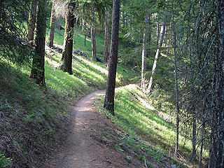 Mission Ridge Trail 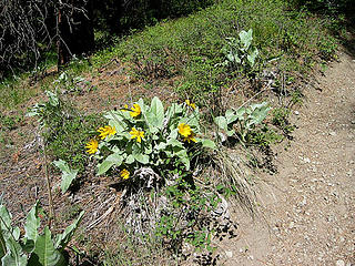 Balsamroot 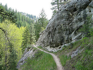 Devils Gulch Trail
|
| Back to top |
  
|
|
Jeff R
Closet hiker.
Joined: 10 Apr 2005
Posts: 972 | TRs | Pics
Location: Everret |
|
Jeff R
Closet hiker.
|
Mon May 02, 2005 3:58 pm |
|
|
Thanks Jimk for the inside scoop sounds like I might have to trade in my hiking shoes for my bike friday!
|
| Back to top |
|
|
JimK
Member
Joined: 07 Feb 2002
Posts: 5606 | TRs | Pics
Location: Ballard |
|
JimK
Member
|
Mon May 02, 2005 4:22 pm |
|
|
I wouldn't recommend the Devils Gulch trail on a Bike Friday. 
|
| Back to top |
|
|
wildernessed
viewbagger

Joined: 31 Oct 2004
Posts: 9275 | TRs | Pics
Location: Wenatchee |
I was of all things checking out liberty-beehive road, running and walking it, the day you hiked the loop( was at and S of Devils Gulch S terminus TH), the road is snow free so I wish they would open the gates. I though it was beautiful and diverse, you articulated it very well. I encountered no bikes or people. I did Tronsen Ridge in the same week, also awesome. I imagine you could drive to Upper Naneum Meadows about now. Thanks for the report.  wildernessed
Living in the Anthropocene
Living in the Anthropocene
|
| Back to top |
|
|
Jeff R
Closet hiker.

Joined: 10 Apr 2005
Posts: 972 | TRs | Pics
Location: Everret |
|
Jeff R
Closet hiker.
|
Mon May 02, 2005 4:41 pm |
|
|
|
| Back to top |
|
|
Get Out and Go
Member

Joined: 13 Nov 2004
Posts: 2129 | TRs | Pics
Location: Leavenworth |
Of all wildflowers, Tweedy's Lewisia is my favorite, a real marker of spring. As I mentioned in my recent report, there are some beautiful delicate clumps at their peak growing out of the rocks 3-4 miles up the Icicle Ridge trail. Other areas where I've seen them are the Chiwaukum Creek Trail, Lower Snow Lakes Trail and Tumwater Mountain, which is up Ranger Road from Leavenworth. They are quite an amazing flower, able to take root in granite. Apparently they are like icebergs, in that most of the plant is below the surface in the root. They must live for years. You can always find the same plant year after year.
"These are the places you will find me hiding'...These are the places I will always go."
(Down in the Valley by The Head and The Heart)
"Sometimes you're happy. Sometimes you cry.
Half of me is ocean. Half of me is sky."
(Thanks, Tom Petty)
"These are the places you will find me hiding'...These are the places I will always go."
(Down in the Valley by The Head and The Heart)
"Sometimes you're happy. Sometimes you cry.
Half of me is ocean. Half of me is sky."
(Thanks, Tom Petty)
|
| Back to top |
|
|
tennessee treader
Member

Joined: 19 Jan 2005
Posts: 337 | TRs | Pics
Location: Trapped in Tennessee :( |
I am a Washington native transplanted in Tennessee. I plan on doing this loop solo when I come up next week, but will break it up to an overnighter. Any suggestions on a good halfway point? Thanks for the good report; it convinced me on my destination. 
baseball and hiking ... that's life!
baseball and hiking ... that's life!
|
| Back to top |
|
|
JimK
Member
Joined: 07 Feb 2002
Posts: 5606 | TRs | Pics
Location: Ballard |
|
JimK
Member
|
Wed May 04, 2005 7:20 am |
|
|
TT,
There is no water on Mission Ridge or any snow either. There are several camp spots in the 7 1/2 miles up Devils Gulch but they are not near the mid point. I would guess you could camp at the final crossing of Mission Creek before or after the route from the ridge top to the creek, depending on which direction you go. I didn't really notice if there was much room to camp there but it's likely. There are creeks along the climb to the ridge top and a large flat area where the Mission Ridge and Devils Gulch trails intersect. That is near the middle, about 8 miles via Mission Ridge and 9 miles via Devils Gulch. You would have to go down a ways to get water at a stream and bring it back up. One of those two should work.
Jim
|
| Back to top |
|
|
tennessee treader
Member
Joined: 19 Jan 2005
Posts: 337 | TRs | Pics
Location: Trapped in Tennessee :( |
Initial look at the maps I figured I would camp where the Mission Ridge and Devils Gulch trails intersect (like you mentioned) and forage down trail for water or carry enough to get me through until breakfast. I will carry a purifier to help in the task. Good to read your email, my "hiker senses" were right on key with your recommendations. Thanks again and I love coming back to Washington for hiking visits!
baseball and hiking ... that's life!
baseball and hiking ... that's life!
|
| Back to top |
|
|
JimK
Member
Joined: 07 Feb 2002
Posts: 5606 | TRs | Pics
Location: Ballard |
|
JimK
Member
|
Fri May 06, 2005 10:51 am |
|
|
|
| Back to top |
|
|
tennessee treader
Member
Joined: 19 Jan 2005
Posts: 337 | TRs | Pics
Location: Trapped in Tennessee :( |
Thanks for the pics. I'll be hiking there on Monday! It will sure be good to get away from the office for a few days.
baseball and hiking ... that's life!
baseball and hiking ... that's life!
|
| Back to top |
|
|
|
|


 Would you recomend any other day?