| Previous :: Next Topic |
| Author |
Message |
#19
Member


Joined: 17 Dec 2001
Posts: 2197 | TRs | Pics
|
|
#19
Member
|
 Mon Jan 20, 2003 1:52 pm |
|
|
When Brian Curtis identified Bannock Lakes as his "nemesis lakes", I couldn't help but be a little pleased. It is not just me that gets skunked.  My fixation with eruzA has been documented enough on this site - so I won't be going into that AGAIN anytime soon. But, do you have a hiking/scrambling/climbing nemesis? If so: What is it? Did you over come it? Are you still struggling for it?
Tell us..
My fixation with eruzA has been documented enough on this site - so I won't be going into that AGAIN anytime soon. But, do you have a hiking/scrambling/climbing nemesis? If so: What is it? Did you over come it? Are you still struggling for it?
Tell us..
|
| Back to top |
  
|
|
Spin Doctor
Member
|
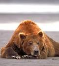
None here, but I once returned to camp to find this guy snoozing in my hammock. He wasn't sleeping peacefully though... From the sounds of it, I think he having having dreadful flashbacks of one particular cascade lake. 
|
| Back to top |
|
|
catwoman
Member

Joined: 16 Dec 2001
Posts: 888 | TRs | Pics
Location: somewhere near Tacoma |
|
catwoman
Member
|
Mon Jan 20, 2003 3:44 pm |
|
|
Well, no wonder he wasn't sleeping peacefully! He's laying on it the wrong way! 
|
| Back to top |
|
|
rubberlegs
Guest
|
|
rubberlegs
Guest
|
Mon Jan 20, 2003 3:47 pm |
|
|
Ah... nemeses. My worst is Marble Peak near Silverton. The first time we tried to follow Dallas Kloke's route. We started from the bridge at Silverton and bushwacked for a few hours, basically getting nowhere. But we found Marble Creek downstream. A valium attempt indeed.
The second time we knew where the creek was, so headed directly downstream from the bridge. Another mighty brush bash but after 45 minutes we got to the creek. Then we headed uphill for quite some time. We found the old miner's trail!! That was a thrill. But alas, we reached a turnaround time. On the return we followed the old trail nearly to Silverton.
The third time we brought two other victims. One of them, it turns out, finds bushwacking to be tedious, unpleasant, and thoroughly upsetting. Basically he whined so much that we left him, and continued on the trail to where it crosses Marble Creek. A magnificent find is this trail! But hard snow and feeling guilty for our two companions below turned us around.
The fourth time just the two of us crazies forded the chilly Stilly and headed uphill for the trail. We made rapid time and followed the trail to where it finally fizzles out (20 feet farther than we'd gone the previous time). After a mighty struggle through vine maple, we emerged on the final easy pitch to Marble Pass. Aha! Plenty of time to summit. But alas, this time the terrain was way beyond our meagre 3rd class skills. We turned back.
The fifth time we went the "right way", which is further west than the Marble Pass trail. We made it within 200' of the summit and hit dense fog. Our spirits dampened, our view gone, and the visible terrain incredibly steep, we turned back yet again.
Last year I wanted to give it another go on a better day, but alas, alack, never got an opportunity. So far it's Marble Peak 5, rubberlegs 0.
|
| Back to top |

|
|
Stefan
Member

Joined: 17 Dec 2001
Posts: 5093 | TRs | Pics
|
|
Stefan
Member
|
Mon Jan 20, 2003 3:59 pm |
|
|
Malachite Peak
1st try. Probably within 1 hour of the summit. I received extreme stomache cramps just after we left Malachite lake so we turned around.
2nd try. Got to Purvis Lake on absolutely gorgeous spring day from the Miller Road. But my partner pooped out from exhaustion at 12:00 and said he couldn't go any further....
3rd try. Went up to Purvis Lake again on another spring day, but the fog was so thick we couldn't really tell which way to go even though we had map, compass, altimeter, and GPS! So we just followed our footprints back down.
4th try. Next time we camped overnight at Malachite Lake with a bunch of friends. It unexpectedly snowed on us for about 6 inches and we were not prepared for those chilly and wet conditions. We just up and left.....
BTW.....It took me only one try to do Marble Peak, and I made it!......HAHHAHAHAHAHAHA!
|
| Back to top |
|
|
Tom
Admin
Joined: 15 Dec 2001
Posts: 17856 | TRs | Pics
|
|
Tom
Admin
|
Mon Jan 20, 2003 5:11 pm |
|
|
| Stefan wrote: | | BTW.....It took me only one try to do Marble Peak, and I made it!......HAHHAHAHAHAHAHA! |
Stefan, it only took me one try to do Malachite Peak.  Then again, I started from Baloney Ridge, not Malachite Lake or the Miller River Road. Then again, I started from Baloney Ridge, not Malachite Lake or the Miller River Road.
|
| Back to top |
|
|
rubberlegs
Guest
|
|
rubberlegs
Guest
|
Mon Jan 20, 2003 7:13 pm |
|
|
One try for Malachite for me too! Hahahahahahahaha! But I have one more non-summit on Marble than you on Malachite. BooHooHooHOoHOoHoohoo!
|
| Back to top |
|
|
MtnGoat
Member

Joined: 17 Dec 2001
Posts: 11992 | TRs | Pics
Location: Lyle, WA |
|
MtnGoat
Member
|
Mon Jan 20, 2003 8:04 pm |
|
|
My Nemesis was Sunset lake, on Trout creek just NE of Index.
Attempt one, trout creek direct. Following Sunset mine road past mine, it deteriorates in the next mile to a road choked with alders, then ends in a steep gully with a small but nasty creek to cross. After getting too late a start, we wind up in high brush on the rib due W of Sunset, and my partner decides he's had enough. Back down we go.
Second try, a couple of years later, we approach from the NE, use logging roads to approach Burley Mtn from the backside, with the intent to go over the summit and drop down to the lake. Due to an unseasonably late snowfall, we are kneedeep in fresh snow and about 1 mile short of the summit of Burley early in the afternoon on a clear day, my partner ( a different one!) again decides they aren't up for it. Son of a !($@!!
Third try, a few years after the last failure, when I've decided I have to go for it again. This time, the plan is to approach from Eagle lake, which takes us up the S face of Mt Townsend. Only to look down and see Simms lake is still iced solid even though little snow remains at Eagle. Due to the conditions of Simms, I cannot convince my latest victim that Sunset may be thawed. Again, I am turned back. This gets old!
Fourth try, with still another buddy. There is no way to convince former co-conspirators to try it again, and after the turnbacks in what I consider tough, but OK conditions on the prior two attempts, I don't want them anyway! I am also concerned about my own sanity, but darnit sometimes the draw of looking at that darned lake on the map, again, all winter long, for years, is just too strong to resist. Again we approach from Eagle and climb Mt Townsend. This time, Simms is open. We glissade the treacherous backside down to Simms for a lookyloo, then cut around the W end of the ridge and *FINALLY* I am standing on the shores of Sunset lake. I'm reasonably sure I wouldn't have had the walking on air feel as I finally saw it, if it hadn't taken so many disappointments to get there. Quite satisfying.
Diplomacy is the art of saying 'Nice doggie' until you can find a rock. - Will Rogers
Diplomacy is the art of saying 'Nice doggie' until you can find a rock. - Will Rogers
|
| Back to top |
|
|
Bushwacker
Comfortable
Joined: 28 Jun 2002
Posts: 834 | TRs | Pics
Location: Chaweng Beach, Koh Samui, Thailand |
| Tom wrote: | | Stefan, it only took me one try to do Malachite Peak. Then again, I started from Baloney Ridge, not Malachite Lake or the Miller River Road. |
Is that anywhere near Liverwurst Pass?
BW 
"Wait by the river long enough and the bodies of your enemies will float by"...Sun Tsu
"Wait by the river long enough and the bodies of your enemies will float by"...Sun Tsu
|
| Back to top |
|
|
Sore Feet
Member

Joined: 16 Dec 2001
Posts: 6305 | TRs | Pics
Location: Out There, Somewhere |
Bushwacker - Due to you're lameness, I hearby revoke your joke telling privilages.
Hmm. How many tries does it take to count as a nemesis?
There's a couple waterfalls next to the Cascade Pass road that I just can't seem to get to.
Gilbert Falls is sort of visible from the road, but just a teeny part (of a pretty big falls). First try, I ran out of time starting right up the creek, and couldn't even get off a picture. Second try, I went up the right side of the creek and was quickly hampered by really thick vine maple. I got off a really bad picture, but at least I got a picture.
Then there's Torment Falls (and the fact that it's on Torment Creek is just a freak coincidence). I figure the base of the falls is about 1/5 of a mile downstream from the last bridge across the Cascade River. The first time, I got about 50 feet from the road and bagged it (no bushwhacking implements). Second try, I tried getting pictures from the opposite side of the river, but there's too many trees in between the falls and the river. Third try, a friend was with me (who's not to keen to bushwhacking), so again, about 50 feet in and bagged. This year is gonna be the year however.
Probably the most discouraging one was the only attempt I've yet made on the Sulphide Creek Basin. Did the Baker River trail in about 1 1/2 hours, then proceeded up Sulphide Creek. I figured I'd have to go about 1 3/4 miles to the base of the big falls up there, and I was counting on being able to travel on the wide gravel streambed, however, July is apparently not the time to do this, because Sulphide Creek was huge. So, I got about 3/4 of a mile up, to a point where the creek edged right to the banks, and the forest gave way to the thickest swath of vine maple / slide brush I've ever seen. It stretched at least 400 vertical feet up the hillside, and fording the creek was absolutely out of the question, so, very disappointed, I had to bag it. I vow to keep returning until I can get this one done. Maybe if this is a low snowpack year, I will have better chances...
|
| Back to top |
|
|
polarbear
Member

Joined: 16 Dec 2001
Posts: 3680 | TRs | Pics
Location: Snow Lake hide-away |
First of all, the bear in the hammock looks about as comfortable as one of those kung fu experts lying on a bed of nails. Maybe his last meal isn't setting well and he needs a tums. Where is the owner of hammock I wonder??
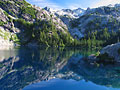
Second, if you have read about my prior attempts to get to SCL then skip this post and do the hike yourself  Attempt 1: Many moons ago...
I got the hike out of one of the old versions of the Bob & Ira Spring books. They don't make hiking books like that anymore do they? I got off to my usual late start. It was very hot that day. I made it to the big washout which is right past the small washout. This was after taking a silly time wasting detour way up a huge boulder boulder draw to check out the view. I reached the washout and turned around. Trail? This wasn't a trail. But the allure was there...
Attempt 2.
Strategy: get up a tiny bit earlier, hike a whole lot faster
Attempt 1: Many moons ago...
I got the hike out of one of the old versions of the Bob & Ira Spring books. They don't make hiking books like that anymore do they? I got off to my usual late start. It was very hot that day. I made it to the big washout which is right past the small washout. This was after taking a silly time wasting detour way up a huge boulder boulder draw to check out the view. I reached the washout and turned around. Trail? This wasn't a trail. But the allure was there...
Attempt 2.
Strategy: get up a tiny bit earlier, hike a whole lot faster  This time I made it past the washout up around the box canyon (forgot to mention the nettles) and across Drop Creek and the next creek and then down to the river a ways. I turned around at maybe 4:30, wishing I had gotten off to an earlier start. It seemed like I had to be right on top of the lake. In reality, I think I had maybe 1.5-2 miles to go. It's no fun hiking the same nasty trail back when you never reach the lake.
Attempt 3.
Brute Force: Forget the day hike, I'll backpack. Even though I don't like backpacking, I figured it was worth the effort and energy. Plus you don't have to leave early because you have a backpack, right? I camped at Drop Creek and felt pretty dead. Going around the Box Canyon really wears out the legs and when you reach the good viewpoint of the river which at this point is a speck way down below, you are only halfway up the box detour. It wasn't dark but it was getting dusky. There was a good camp spot at Drop Creek and I couldn't remember any other good spots farther on and I was tired so I camped. The next day I got up but was still feeling tired from the day before. I reached the second creek and there was alot of water in it. I went up and down the trail trying to figure out how others cross it. That was when I felt the devil's club in my fleece. Ah...now more devils club. Hey, what is that swarming around my legs. Bees all around. Do I run fast to escape or run more slowly and try and kill the ones that are running circles around my legs inside my fleece? I ran slowly and furiously swatted my legs and everywhere else and yelled. At long last the bees were dead or contentedly playing possum. Then I went and found the nest. Then I resumed figuring creek crossing stuff. I crossed the creek and started hiking through the vegitation, real wet stuff. It still felt like there were bees on me though there weren't. Itchiness. Every once in awhile I'd slap myself on the legs or arms just to kill whatever wasn't there. Finally the trail climbs up to...the impenitrable thicket. At least I thought it was and after wading through that awhile with the sun beating on you and the braches clawing at your pack I turned around. Of course a month later I read a report about a couple that made it to the lake
Attempt 4
Read all about it here
This time I made it past the washout up around the box canyon (forgot to mention the nettles) and across Drop Creek and the next creek and then down to the river a ways. I turned around at maybe 4:30, wishing I had gotten off to an earlier start. It seemed like I had to be right on top of the lake. In reality, I think I had maybe 1.5-2 miles to go. It's no fun hiking the same nasty trail back when you never reach the lake.
Attempt 3.
Brute Force: Forget the day hike, I'll backpack. Even though I don't like backpacking, I figured it was worth the effort and energy. Plus you don't have to leave early because you have a backpack, right? I camped at Drop Creek and felt pretty dead. Going around the Box Canyon really wears out the legs and when you reach the good viewpoint of the river which at this point is a speck way down below, you are only halfway up the box detour. It wasn't dark but it was getting dusky. There was a good camp spot at Drop Creek and I couldn't remember any other good spots farther on and I was tired so I camped. The next day I got up but was still feeling tired from the day before. I reached the second creek and there was alot of water in it. I went up and down the trail trying to figure out how others cross it. That was when I felt the devil's club in my fleece. Ah...now more devils club. Hey, what is that swarming around my legs. Bees all around. Do I run fast to escape or run more slowly and try and kill the ones that are running circles around my legs inside my fleece? I ran slowly and furiously swatted my legs and everywhere else and yelled. At long last the bees were dead or contentedly playing possum. Then I went and found the nest. Then I resumed figuring creek crossing stuff. I crossed the creek and started hiking through the vegitation, real wet stuff. It still felt like there were bees on me though there weren't. Itchiness. Every once in awhile I'd slap myself on the legs or arms just to kill whatever wasn't there. Finally the trail climbs up to...the impenitrable thicket. At least I thought it was and after wading through that awhile with the sun beating on you and the braches clawing at your pack I turned around. Of course a month later I read a report about a couple that made it to the lake
Attempt 4
Read all about it here
|
| Back to top |
|
|
Dave Weyrick
Member
Joined: 16 Dec 2001
Posts: 311 | TRs | Pics
Location: Poulsbo, WA |
Jerry Lakes. Only made one try, Labor Day about five years ago. This was before I got into lightweight; must have hauled almost 50lbs up that mile the trail rises including my float tube, fins and neoprene waders. Rain started about noon, so after finding the way trail going counter-clockwise around Crater Mountain and folowing it a bit, I retreated back to the little puddle S of the mountain and camped. Towards dark the weather cleared so I made the mistake of going out scouting. Found a nice trail in the alpenglow going clockwise around the mountain and in my brilliance figured it must go to Jerry Lakes, maybe through the pass between the E and W summits; that's the wqy to go first thing in the morning on a daytrip.
I'd been plotting this excursion for ten years, since a friend fished the lakes on a guided horse pack trip with his brother and some guys from work. He was told you have to go late to give the north side snow field a chance to melt; some years it doesn't and there's no safe way in.
First light found me on the clockwise trail which finally petered out in the cliffs heading to the top of the W summit. Learned later the trail leads to a fire lookout site and I'd been on the right track the day before in the rain. Just enough energy and time left to haul all my stuff back down the trail to my car, which I'd been able to see from the several places above camp.
Anyone been to Jerry Lakes? I'm thinkin' about late September....
If I'd known ya was gonna use bait I wouldn't a brought ya!
If I'd known ya was gonna use bait I wouldn't a brought ya!
|
| Back to top |
|
|
Brian Curtis
Trail Blazer/HiLaker

Joined: 16 Dec 2001
Posts: 1696 | TRs | Pics
Location: Silverdale, WA |
I've been to the Jerrys, Dave. You just go right over the top of Crater Mtn.
that elitist from silverdale wanted to tell me that all carnes are bad--Studebaker Hoch
that elitist from silverdale wanted to tell me that all carnes are bad--Studebaker Hoch
|
| Back to top |
|
|
lopper
off-route

Joined: 22 Jan 2002
Posts: 845 | TRs | Pics
|
|
lopper
off-route
|
Tue Jan 21, 2003 10:49 am |
|
|
We used the col route between E and W Crater.
Details in email.
Great Place---worth the foot pounding.
|
| Back to top |
|
|
Randy
Cube Rat

Joined: 18 Dec 2001
Posts: 2910 | TRs | Pics
Location: Near the Siamangs |
|
Randy
Cube Rat
|
Tue Jan 21, 2003 7:18 pm |
|
|
Just one so far. Avalanche Lake up the MFK Snoqualmie. Back when I was into lakes, this was a top priority via Burntboot Creek as a day trip. I've had my arse handed to me twice from one end of Burnboot Creek to the other. The first time (2000), we got to within a 1/4 mile of the lake before my buddy gets injured. We had to turn around for the LONG trip back. Second time (2001) was with Beave and same buddy as the first trip. Even worse with a messed up route and party seperation. In 2002 we did Summit Chief in a day instead and it was way, WAY easier. 
|
| Back to top |
|
|
|
|
You cannot post new topics in this forum
You cannot reply to topics in this forum
You cannot edit your posts in this forum
You cannot delete your posts in this forum
You cannot vote in polls in this forum
|
Disclosure: As an Amazon Associate NWHikers.net earns from qualifying purchases when you use our link(s). |


