| Previous :: Next Topic |
| Author |
Message |
wildernessed
viewbagger


Joined: 31 Oct 2004
Posts: 9275 | TRs | Pics
Location: Wenatchee |
Location : 32 miles NW of Leavenworth. End of White River Rd. Indian head Creek TH
Access : road conditions good SR 207 > Wenatchee River Rd> White River Rd.
Maps : This area is partially on 4 GTM, I used a TOPO custom map
Stats : To Airplane Lake : 5.5 mi. and 3050', to Mt. Saul summit 6.8 and 5000',roundtrip 14 mi, 5250', 13.5 hr.
I had missed last weeks trip into the "Lost World Plateau"  and needed a fix after several weeks, especially with this great weather. I talked to Steve about more than a few options, of course as usual we wanted it all and we wanted it all day. He mentioned something about Airplane Lake and I looked at the map and noted Mt. Saul above it to the W and we agreed to agree on it tentatively weather pending. There are no trails to the lake or summit I noted, and all the gain subtracting Indian Head Creeks level path would be off trail basically 5000' in 2-3 miles, of which 3000' of that was in the first mile. Doing a little searching I found several TR's which disclosed a fishermens / climbers path and Steve had heard of this so we had some good beta on where to go off trail and needed a fix after several weeks, especially with this great weather. I talked to Steve about more than a few options, of course as usual we wanted it all and we wanted it all day. He mentioned something about Airplane Lake and I looked at the map and noted Mt. Saul above it to the W and we agreed to agree on it tentatively weather pending. There are no trails to the lake or summit I noted, and all the gain subtracting Indian Head Creeks level path would be off trail basically 5000' in 2-3 miles, of which 3000' of that was in the first mile. Doing a little searching I found several TR's which disclosed a fishermens / climbers path and Steve had heard of this so we had some good beta on where to go off trail  .
We were on the trail at 0630 Sun. using headlamps and made our way quickly on the very level and scenic Indian Head Creek Trail, the fall colors were striking .
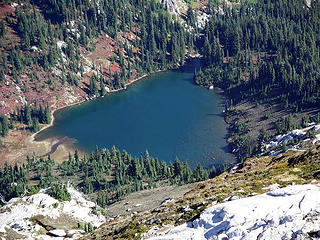
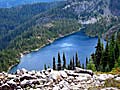
We were on the trail at 0630 Sun. using headlamps and made our way quickly on the very level and scenic Indian Head Creek Trail, the fall colors were striking  . Maybe 4-5 miles in we found an old campsite (very prominent) and the trail opposite that on our right faint at first, but becoming very prominent after that (smells fishy . Maybe 4-5 miles in we found an old campsite (very prominent) and the trail opposite that on our right faint at first, but becoming very prominent after that (smells fishy  ). The trail heads strait up the gut with plenty of blowdown and overgrowth, luckily it was clear and cool out and we just kept on keeping on arriving at the lake in 4.5 hr. next to the outlet. A beautiful lake adorned with fall colors and the rocky basin of Mt. Saul high above us ). The trail heads strait up the gut with plenty of blowdown and overgrowth, luckily it was clear and cool out and we just kept on keeping on arriving at the lake in 4.5 hr. next to the outlet. A beautiful lake adorned with fall colors and the rocky basin of Mt. Saul high above us  . We dropped packs briefly filled our water supply and ate some energy food. You just can't loiter to long around these lakes, they can alter you sensorium and you might never make that peak . We dropped packs briefly filled our water supply and ate some energy food. You just can't loiter to long around these lakes, they can alter you sensorium and you might never make that peak  . We left crossing the outflow over a log jam and decided to take Southern of the E ridges which looked easiest and quickest and huffed up and inward to the rocky basin with it's boulder field and slab rock. Once up we decided to cross the boulder field and take a heather covered ramp up to the N gain the ridge and see what was next. Just over the ridge was another narrow plateau of slab rock, heather, boulders, and a nice long snowfield which lead back to the S and the summit of Saul. It was rather cool, but we had clear skies and great views of Glacier, Kodak, Sloan, Ten Peaks, Clark, David etc..., after maybe 30 min. we descended after getting a birds eye view of the lake and decided to return via the other side of the lake, so after the rock we ambled down heather and lightly forested slopes and around to the penninsula side of the lake. Gorgeous wide open area. Steve broke out the telescoping pole and with each cast, a hit, and a fish. After maybe 5-10 min. he was all smiles and that just added to an already feature packed day with remoteness, ridges, a lake, a peak, fish and the fall colors and weather. We headed back suffering the impact, but it seemed to go by quickly maybe because it's strait down. I must say though that even though the path is tough, it gets some use for some reason . We left crossing the outflow over a log jam and decided to take Southern of the E ridges which looked easiest and quickest and huffed up and inward to the rocky basin with it's boulder field and slab rock. Once up we decided to cross the boulder field and take a heather covered ramp up to the N gain the ridge and see what was next. Just over the ridge was another narrow plateau of slab rock, heather, boulders, and a nice long snowfield which lead back to the S and the summit of Saul. It was rather cool, but we had clear skies and great views of Glacier, Kodak, Sloan, Ten Peaks, Clark, David etc..., after maybe 30 min. we descended after getting a birds eye view of the lake and decided to return via the other side of the lake, so after the rock we ambled down heather and lightly forested slopes and around to the penninsula side of the lake. Gorgeous wide open area. Steve broke out the telescoping pole and with each cast, a hit, and a fish. After maybe 5-10 min. he was all smiles and that just added to an already feature packed day with remoteness, ridges, a lake, a peak, fish and the fall colors and weather. We headed back suffering the impact, but it seemed to go by quickly maybe because it's strait down. I must say though that even though the path is tough, it gets some use for some reason  . We hit the Indian Head Creek Trail and picked the pace up getting back about 8:00pm with headlamps. Another great day in the mountains with a great guy. Thanks Steve. . We hit the Indian Head Creek Trail and picked the pace up getting back about 8:00pm with headlamps. Another great day in the mountains with a great guy. Thanks Steve. 
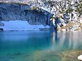
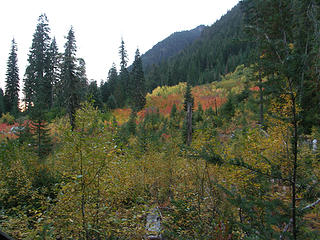 Fall color along Indian Head Creek Trail 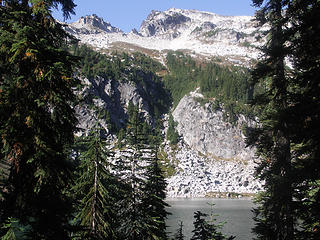 First views up the Airplane Lake Drainage of Airplane Lake Basin and Mt. Saul 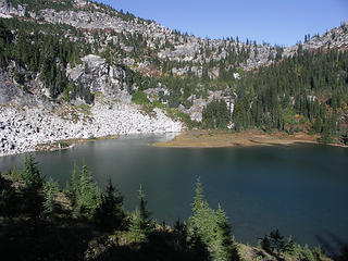 Looking toward the penninsula on the N side of Airplane Lake 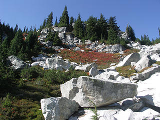 Beautiful sectio of the SE ridge we followed to Mt. Saul's Basin 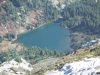 Airplane Lake from Mt. Saul Basin 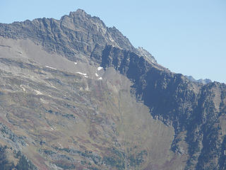 Point 8373 on Clark Mtn. note the break in the upper ridge line and the ramp leading NE to Clarks summit. This is one route from Boulder Creek Basin to Clark. 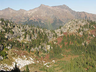 Basin, NE ridge / saddle of Mt. Saul, and Clark Mtn. from the S 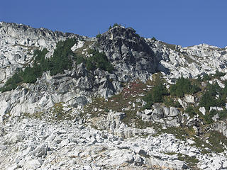 From the SE ridge approach we crossed a boulder and snow field over to the vegetated ramp and took steep slopes to the ridge and over heading back S to Mt. Sauls summit (class 2) 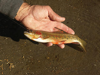 Steve playing cast, catch, and release with the Cutthroat trout
Living in the Anthropocene
Living in the Anthropocene
|
| Back to top |
  
|
|
Backpacker Joe
Blind Hiker

Joined: 16 Dec 2001
Posts: 23956 | TRs | Pics
Location: Cle Elum |
I dont see any airplanes?  
"If destruction be our lot we must ourselves be its author and finisher. As a nation of freemen we must live through all time or die by suicide."
Abraham Lincoln
"If destruction be our lot we must ourselves be its author and finisher. As a nation of freemen we must live through all time or die by suicide."
Abraham Lincoln
|
| Back to top |
|
|
wildernessed
viewbagger
Joined: 31 Oct 2004
Posts: 9275 | TRs | Pics
Location: Wenatchee |
I wondered about that name, I thought well, maybe a plane crashed there or somethhing, someone said, well it looks like an airplane ?, maybe with some imagination, maybe a stealth bomber, but someone might have an idea on that. 
Living in the Anthropocene
Living in the Anthropocene
|
| Back to top |
|
|
Get Out and Go
Member

Joined: 13 Nov 2004
Posts: 2130 | TRs | Pics
Location: Leavenworth |
Way to go guys Only wish I had gone, but the masses' thirst had to be quenched at Oktoberfest  so I didn't get home until 1 in the morning.......That sounds like a toughie, bookended with headlamps. so I didn't get home until 1 in the morning.......That sounds like a toughie, bookended with headlamps.
"These are the places you will find me hiding'...These are the places I will always go."
(Down in the Valley by The Head and The Heart)
"Sometimes you're happy. Sometimes you cry.
Half of me is ocean. Half of me is sky."
(Thanks, Tom Petty)
"These are the places you will find me hiding'...These are the places I will always go."
(Down in the Valley by The Head and The Heart)
"Sometimes you're happy. Sometimes you cry.
Half of me is ocean. Half of me is sky."
(Thanks, Tom Petty)
|
| Back to top |
|
|
wildernessed
viewbagger
Joined: 31 Oct 2004
Posts: 9275 | TRs | Pics
Location: Wenatchee |
My swollen left knee is telling me it was, and Steve considered doing a midweek hike, but after that he said he was rethinking the midweek thing in favor of some recovery time. I have to take it easy and save myself for next weekend.
Living in the Anthropocene
Living in the Anthropocene
|
| Back to top |
|
|
Dayhike Mike
Bad MFKer
Joined: 02 Mar 2003
Posts: 10955 | TRs | Pics
Location: Going to Tukwila |
Nice TR!
Hope you don't mind, but I threw two of your pics into PhotoShop and applied auto-levels to de-haze them. That point 8373 looks pretty nice...
 airplane-lake
"There is only one basic human right, the right to do as you damn well please. And with it comes the only basic human duty, the duty to take the consequences." -P.J. O'Rourke
"Ignorance is natural. Stupidity takes commitment." -Solomon Short
"There is only one basic human right, the right to do as you damn well please. And with it comes the only basic human duty, the duty to take the consequences." -P.J. O'Rourke
"Ignorance is natural. Stupidity takes commitment." -Solomon Short
|
| Back to top |
|
|
wildernessed
viewbagger
Joined: 31 Oct 2004
Posts: 9275 | TRs | Pics
Location: Wenatchee |
WOW, bomber the gulley looks like a steep climb, but the notch in the ridge near the top and the ramp you descend to looks much better, more 3 dimensional.
Living in the Anthropocene
Living in the Anthropocene
|
| Back to top |
|
|
Spotly
Member

Joined: 06 Jan 2004
Posts: 3723 | TRs | Pics
Location: Spokane Valley |
|
Spotly
Member
|
 Mon Oct 02, 2006 5:47 pm |
|
|
Getting to 8373 looks sick!
|
| Back to top |
|
|
b00
Member

Joined: 29 Sep 2003
Posts: 1145 | TRs | Pics
|
|
b00
Member
|
Tue Oct 03, 2006 12:57 am |
|
|
another nice tr :>) i was up this peak a few years ago, thanks for the memories and photo's, what a great trip! you pick some cool places to visit.
|
| Back to top |
|
|
wildernessed
viewbagger
Joined: 31 Oct 2004
Posts: 9275 | TRs | Pics
Location: Wenatchee |
| b00 wrote: | | another nice tr :>) i was up this peak a few years ago, thanks for the memories and photo's, what a great trip! you pick some cool places to visit. |
Thanks b00, the same can be said for you, I always enjoy your trips and contributions. Fortunately I have come to benefit from, respect, and enjoy the company and ambitions of some knowledgeable and adventuresome people who love the outdoors and favor remoteness and solitude over the beaten path if possible. So many TR's here from so many great places, it seems if you read them and see the pics it's like you've just been there yourself, so you start looking through maps and guidebooks for something different in the near term and stumble on some good stuff.
Living in the Anthropocene
Living in the Anthropocene
|
| Back to top |
|
|
nuclear_eggset
Member
Joined: 02 Jul 2006
Posts: 2206 | TRs | Pics
Location: Eastside |
I think it looks a bit like a stealth. Or the blended wing things they're going to these days (in concept).
Nice pics! Looks lovely!
|
| Back to top |
|
|
Allison
Feckless Swooner

Joined: 17 Dec 2001
Posts: 12287 | TRs | Pics
Location: putting on my Nikes before the comet comes |
|
Allison
Feckless Swooner
|
Tue Oct 03, 2006 4:29 pm |
|
|
o/t, but DHM can you share your best P-Shop "de-hazing" technique? I have a couple of tricks, but I think your way might be better.
thx
www.allisonoutside.com
follow me on Twitter! @AllisonLWoods
www.allisonoutside.com
follow me on Twitter! @AllisonLWoods
|
| Back to top |
|
|
Dayhike Mike
Bad MFKer
Joined: 02 Mar 2003
Posts: 10955 | TRs | Pics
Location: Going to Tukwila |
| marylou wrote: | | o/t, but DHM can you share your best P-Shop "de-hazing" technique? I have a couple of tricks, but I think your way might be better. |
In this case, I was just being lazy and applied an Auto-Levels from within Photoshop.
Typically, I'll apply Auto-Contrast, then Auto-Levels and decide which looks better and use one or the other. If neither gives good results, i.e. blows out the highlights / overdarkens the shadows, I'll go in and manually work with levels and curves.
Auto-Contrast and Auto-Levels fix 90% of the problems most people encounter, though. Amazing how much better things look without the haze, green cast, blue cast, etc. 
"There is only one basic human right, the right to do as you damn well please. And with it comes the only basic human duty, the duty to take the consequences." -P.J. O'Rourke
"Ignorance is natural. Stupidity takes commitment." -Solomon Short
"There is only one basic human right, the right to do as you damn well please. And with it comes the only basic human duty, the duty to take the consequences." -P.J. O'Rourke
"Ignorance is natural. Stupidity takes commitment." -Solomon Short
|
| Back to top |
|
|
wildernessed
viewbagger
Joined: 31 Oct 2004
Posts: 9275 | TRs | Pics
Location: Wenatchee |
| Spotly wrote: | | Getting to 8373 looks sick! |
Get Out and Go and Steve reconned the area below Clark a few weeks back, most people take The Boulder Creek Trail to the basin and head W - NW doing a rising traverse of the S gulley or the ridge route to about 8000' below the 8300'plus point then drop down through that break in the ridge and head W towards Clark as an overnighter. A strait up the gut via the S gulley was being considered as a dayhike and I want to say it was some 6700' gain in 2 miles or so. The descent would be the sickest part, but there are some sick individuals out there.  I took a bunch of pics just to get a feeling for the ridge / gulley / route. I took a bunch of pics just to get a feeling for the ridge / gulley / route.
Living in the Anthropocene
Living in the Anthropocene
|
| Back to top |
|
|
Backpacker Joe
Blind Hiker
Joined: 16 Dec 2001
Posts: 23956 | TRs | Pics
Location: Cle Elum |
Michael, are you using full on Pshop, or Elements?
"If destruction be our lot we must ourselves be its author and finisher. As a nation of freemen we must live through all time or die by suicide."
Abraham Lincoln
"If destruction be our lot we must ourselves be its author and finisher. As a nation of freemen we must live through all time or die by suicide."
Abraham Lincoln
|
| Back to top |
|
|
|
|


