| Previous :: Next Topic |
| Author |
Message |
yew
non-technical

Joined: 12 Dec 2005
Posts: 1173 | TRs | Pics
Location: Bellingham |
|
yew
non-technical
|
 Tue May 01, 2007 12:20 am |
|
|
The weather forecast for both the west slope and east slope North Cascades was looking pretty poor Thursday night so I bailed on my proposition for hiking partners for trips to celebrate the opening of State Route 20, the North Cascades Highway. After a quick consultation with the National Weather Service, Weather Channel and Accuweather.com, I decided to flee south of the storm track to ski corn snow and hike forests of the Oregon Cascades with additional consultation from Mr. Klindt Vielbig author of Cross Country Ski Routes: Oregon.
It was about a 6 hour drive to Detroit (Oregon) with negligible traffic in Seattle, Portland and Salem. Friday, it was cloudy and showery from Bellingham to Everett, then mostly cloudy from Everett to Ridgefield. The sun came out in earnest at Portland with temps at 70 degrees-ish.
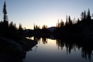
Drove up toward Elk Lake from Detroit. Elk Lake is on the boundary of the Bull of the Woods Wilderness south of Battle Axe Mountain. Hit snow at about 3600 feet, parked, then put on the cross-country skis, then slid on the slushy snow in 60 degrees air temperature. Its just plain weird cross-country skiing in your hiking outfit when its 60 degrees. But, skis were the way to go. Without them I wouldve sunk into slush about to mid-calf. Heres Elk Lake.
Ran out of time to go to Beachie Saddle.
Skied back to the car on new tracks since some booter walked/destroyed on my hard-earned/worked ski tracks. Camped on the Pamelia Rd. Got a fire going. The wood burned real nice, a bit dry for late April. It's been drier down there than in western WA.
Next morning drove up to Santiam Pass and Hoodoo Ski Area. Slapped the climbing skins on the burly touring skis to see how the new releasable cable bindings ski i.e. to see how the bindings perform and if REI mounted them right. The view of Mt Washington & Three Sisters and Three Finger Jack & Mt Jefferson and the 2003 B&B Fire from the top of Hoodoo was nice!
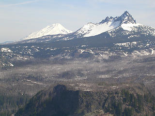 Mt Jefferson and Three Fingered Jack from Hoodoo  on a featureless former logging road but atleast scout the correct route from the top of an old clearcut that has been precommercially thinned recently
Back down then back on track to finally hit continuous slushy snow and best of all, a view and direct route to Coffin Mountain.
Bear tracks cross the road. Poor dogs; its warm and theyre getting tired. Stash the skis then hike up on the official trail. See fresh boot tracks/post holes from someone else. But alas, we can see for miles and miles, from Mt Jeff all the way down south of Three Sisters! on a featureless former logging road but atleast scout the correct route from the top of an old clearcut that has been precommercially thinned recently
Back down then back on track to finally hit continuous slushy snow and best of all, a view and direct route to Coffin Mountain.
Bear tracks cross the road. Poor dogs; its warm and theyre getting tired. Stash the skis then hike up on the official trail. See fresh boot tracks/post holes from someone else. But alas, we can see for miles and miles, from Mt Jeff all the way down south of Three Sisters!
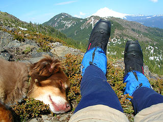 tired dog on Coffin Mountain Oregon on spring cross country ski tour. Near Marion Forks, Oregon  Coffin Mountain on Willamette National Forest Oregon 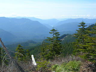 looking west at Oregon Cascades to Detroit Res from Coffin Mountain near Marion Forks, Oregon.  . He also emphasized that spring is kind of the best time of year to ski even though a lot of folks give it up by then.
Anyway
he had slide photo of him and his wife in hiking boots and shorts carrying skis up to Jefferson Park. This must have been like in June. I was captivated and thought Thats what I gotta do!. 7+ years later, I went for it and hit snow at about 3700 feet on FR 4685 about ¾ mile short of the trailhead. More of the lame-arse ski/take-skis-off/hike/put-skis-back-on routine. The snow was hard in morning. A few blowdowns and intermittent snow on the lower part of the Whitewater Trail. Hit more consistent snow at the first switchback then its bare again in magnificent old-growth Douglas-fir forest. Hit consistent snow about 1 mile in and skied all of the way up to the ridgetop trail, the junction with trails #3429 and #3373 up on the ridge.
Saw recent ski tracks. Tried to follow the ridgetop trail to the Sentinel Hills but the hillside was too steep for boot or ski so turned around in defeat.
Sorry I can't ski the above. Atleast there was a good view of the upper South Fork Breitenbush canyon.
Descended with survival skiing slush avoiding tree wells and booting it in plastic tele/touring boots. Nice Doug-fir old growth lower down
To top off the afternoon, we hiked up to Pamelia Lake near where we camped for 3 nights. Pamelia Lake is apparently a very popular hike in the Mt Jefferson Wilderness is part of Limited Entry Area along with other lakes in the Wilderness. You need a permit just to dayhike into there from May 31 Oct 31. If you don't have one it's a $100 ticket! A massive debris flow from awful, infamous Nov. 2006 storm laid down a new carpet of sediment, rocks, boulders, gravel, etc. pretty much covered the middle half of the 2.5 mile trail.
It is flagged through the mucky part and snow covers the last ½ mile or so to the lake. At the lake we watched a male (presumably) duck chase a mate back and forth. Theres a very nice noble fir (Abies procera) stand on the north side of the lake. Love those turkey feet! Unfortunately, Mt Jeff was covered by clouds.
Next day, we drove back to the north country. I really miss the diversity of Oregon forests. The tall, craggy, wild mountains of the North Cascades sure are nice but the white pines, noble firs, white oaks, many elk, rhododendron are just as nice but in a different, mellower way. And, its not quite as cold and rainy down in Oregon. And avalanches are nowhere as much of an issue for the solo skier or winter traveler down there as in the North Cascades. Hmmm? . He also emphasized that spring is kind of the best time of year to ski even though a lot of folks give it up by then.
Anyway
he had slide photo of him and his wife in hiking boots and shorts carrying skis up to Jefferson Park. This must have been like in June. I was captivated and thought Thats what I gotta do!. 7+ years later, I went for it and hit snow at about 3700 feet on FR 4685 about ¾ mile short of the trailhead. More of the lame-arse ski/take-skis-off/hike/put-skis-back-on routine. The snow was hard in morning. A few blowdowns and intermittent snow on the lower part of the Whitewater Trail. Hit more consistent snow at the first switchback then its bare again in magnificent old-growth Douglas-fir forest. Hit consistent snow about 1 mile in and skied all of the way up to the ridgetop trail, the junction with trails #3429 and #3373 up on the ridge.
Saw recent ski tracks. Tried to follow the ridgetop trail to the Sentinel Hills but the hillside was too steep for boot or ski so turned around in defeat.
Sorry I can't ski the above. Atleast there was a good view of the upper South Fork Breitenbush canyon.
Descended with survival skiing slush avoiding tree wells and booting it in plastic tele/touring boots. Nice Doug-fir old growth lower down
To top off the afternoon, we hiked up to Pamelia Lake near where we camped for 3 nights. Pamelia Lake is apparently a very popular hike in the Mt Jefferson Wilderness is part of Limited Entry Area along with other lakes in the Wilderness. You need a permit just to dayhike into there from May 31 Oct 31. If you don't have one it's a $100 ticket! A massive debris flow from awful, infamous Nov. 2006 storm laid down a new carpet of sediment, rocks, boulders, gravel, etc. pretty much covered the middle half of the 2.5 mile trail.
It is flagged through the mucky part and snow covers the last ½ mile or so to the lake. At the lake we watched a male (presumably) duck chase a mate back and forth. Theres a very nice noble fir (Abies procera) stand on the north side of the lake. Love those turkey feet! Unfortunately, Mt Jeff was covered by clouds.
Next day, we drove back to the north country. I really miss the diversity of Oregon forests. The tall, craggy, wild mountains of the North Cascades sure are nice but the white pines, noble firs, white oaks, many elk, rhododendron are just as nice but in a different, mellower way. And, its not quite as cold and rainy down in Oregon. And avalanches are nowhere as much of an issue for the solo skier or winter traveler down there as in the North Cascades. Hmmm?
"I aint jokin woman, I got to ramble...We gonna go walkin through the park every day." - Led Zeppelin
"I aint jokin woman, I got to ramble...We gonna go walkin through the park every day." - Led Zeppelin
|
| Back to top |
  
|
|
Tazz
Member

Joined: 27 Apr 2005
Posts: 7902 | TRs | Pics
|
|
Tazz
Member
|
Tue May 01, 2007 12:29 am |
|
|
Wow you went south!! Sweet! thanks!
I love coffin mt!
|
| Back to top |
|
|
yew
non-technical
Joined: 12 Dec 2005
Posts: 1173 | TRs | Pics
Location: Bellingham |
|
yew
non-technical
|
Tue May 01, 2007 11:25 am Go South!
|
|
|
Tazz:
Going south is good. With the exception of late July through late September, I like the Oregon Cascades more than Washington's North Cascades and Mt Baker where I usually go.
The North Cascades and Mt Baker are too avalanche prone (esp. for people who ski alone), too steep and rugged to ski for all but very good skiers, not enough trails, and too rainy and cloudy. The Oregon Cascades are a happy medium.
"I aint jokin woman, I got to ramble...We gonna go walkin through the park every day." - Led Zeppelin
"I aint jokin woman, I got to ramble...We gonna go walkin through the park every day." - Led Zeppelin
|
| Back to top |
|
|
fettster
Member
Joined: 29 Apr 2007
Posts: 182 | TRs | Pics
Location: Hillsboro, OR |
|
fettster
Member
|
Tue May 01, 2007 8:51 pm |
|
|
|
| Back to top |
|
|
yew
non-technical
Joined: 12 Dec 2005
Posts: 1173 | TRs | Pics
Location: Bellingham |
|
yew
non-technical
|
Wed May 02, 2007 10:31 am skiing to Jeff Park
|
|
|
Fettster:
We had to park about 1/2 to 3/4 mile short of the Whitewater Creek Trailhead and ski & hike intermittent snow patches. There were no blowdowns over the road.
We were too early in the year to make it all the way to Jefferson Park as described in Klindt Vielbig's X-C ski guidebook and his 2 slideshows. Given this year's snowpack and snowline, I think it'd be better to have the lower end of the trail snowfree to hike and carry skis or snowshoes to a snowline in the Sentinel Hills. I don't know...maybe late May or June?
There were old tracks from fat skis on the road and up top on the ridge that looked a day old (the TAY TR is dated for Saturday) but I lost them up high. Looking at that TAY trip report they apparently know a better access route than I do.
"I aint jokin woman, I got to ramble...We gonna go walkin through the park every day." - Led Zeppelin
"I aint jokin woman, I got to ramble...We gonna go walkin through the park every day." - Led Zeppelin
|
| Back to top |
|
|
|
|
You cannot post new topics in this forum
You cannot reply to topics in this forum
You cannot edit your posts in this forum
You cannot delete your posts in this forum
You cannot vote in polls in this forum
|
Disclosure: As an Amazon Associate NWHikers.net earns from qualifying purchases when you use our link(s). |


