| Previous :: Next Topic |
| Author |
Message |
yew
non-technical


Joined: 12 Dec 2005
Posts: 1173 | TRs | Pics
Location: Bellingham |
|
yew
non-technical
|
 Sun Dec 07, 2008 8:11 pm |
|
|
This TR is a quick copy & paste from my outdoors blog so some of the wording may sound a little weird...
Last few years we could've been skiing near Mt Baker this time of the year. This autumn's weather has been mild so far. The only time it has been a little cold is when it's dry. The snowline in the Cascades goes up to over 5000 feet elevation much of the time when it rains. There's only less than a foot of snow at Mt Baker Ski Area as of yesterday 12/06/08. When it's like this, it's good conditions for a dayhike on a beach, in town or in the foothills.
Last Sunday, on 11/30/08, we hiked up the gated powerline corridor road from the North Shore Lake Whatcom trailhead outside of Bellingham. Elvis did this hike last spring, methinks and did a TR on it. There was a brief break in the rain this afternoon so we had to get to the woods for atleast a few hours. This hike is Hike 47, Stewart Mountain, in the "Lowlands & Foothills" chapter of Ken Wilcox's Hiking Whatcom County (5th edition). There's a short stretch of county park land near the gate but beyond that it's state DNR and probably some private timber company land too. It's a typical Pacific Northwest logging road that passes through second growth forests of varying ages.
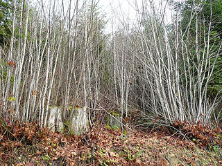 young forest in western Washington is good ruffed grouse habitat esp. if it has an edge like an old or gated gravel logging road 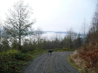 gated logging road hiking in the woods above Lake Whatcom Washington 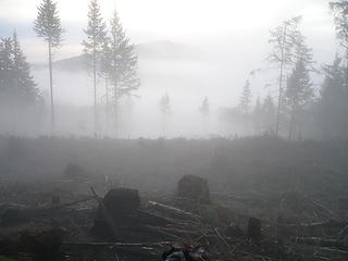 mist lifting from a recent logging operation on Washington state DNR land in western Washington 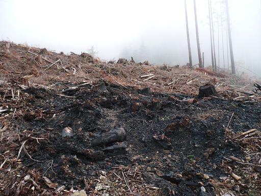 burnt slash pile on Washington DNR land in recent logged area east of Lake Whatcom. Looks bad now but it'll grow back soon and it's a lot better than houses and driveways. 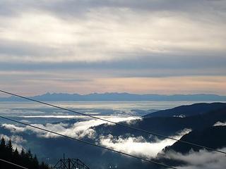 Olympic Mtns, lowlands near Burlington and Lookout Mtn from powerlines on Stewart Mtn 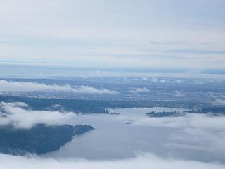 Lake Whatcom and Bellingham from Stewart Mtn powerline corridor 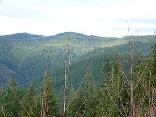 Stewart Mtn 3050' from the powerline corridor road above Lake Whatcom, Washington
"I aint jokin woman, I got to ramble...We gonna go walkin through the park every day." - Led Zeppelin
"I aint jokin woman, I got to ramble...We gonna go walkin through the park every day." - Led Zeppelin
|
| Back to top |
  
|
|
Elvis
Shuffl'n

Joined: 09 Jun 2004
Posts: 1804 | TRs | Pics
Location: del Boca Vista |
|
Elvis
Shuffl'n
|
Sun Dec 07, 2008 11:17 pm |
|
|
Howdy Y.B.!
Glad you recall the earlier trip report - there were actually three of them as that's how many times it took before I finally reached the high point.
Third attempt Trip Report (with some summertime, sunny pictures).
My trip out there started out based on your suggestions from a prior B'ham NWHikers social, if you didn't know. Somewhere along the way someone referred to this peak as Whacme Peak (a combination of Whatcom (the lake) and Acme (the little "town" on hwy 9)). I don't see either of those names in my Topo! maps.
Also, FWIW, in Ken Wilcox's Hiking Whatcom County 3rd edition he only mentions Stewart Mtn briefly in the 'other trails' section. I'd be interested in reading what he has to add about it in the 5th (or newer) editions.
Finally, I agree it's not wilderness but it is a dang good workout!
~E
"Ill habits gather unseen degrees, as brooks make rivers, rivers run to seas." ~John Dryden
My Trip List
"Ill habits gather unseen degrees, as brooks make rivers, rivers run to seas." ~John Dryden
My Trip List
|
| Back to top |
|
|
Eric
Peak Geek

Joined: 21 Oct 2002
Posts: 2062 | TRs | Pics
Location: In Travel Status |
|
Eric
Peak Geek
|
Mon Dec 08, 2008 12:48 pm |
|
|
| Quote: | | To the northeast is Stewart Mtn's highest knob at 3050' which is more timbered land covered with second growth forest. I want to get up here really bad, possibly with the mountain bike to cover more ground. I don't know the shortest way to access this area. I have ridden my mountain bike in from the horse trail area on the Y Road but didn't come close to Stewart. |
I've been up to the two highest areas on this massif, Whacme which is the unofficial name for the peak Elvis tagged that is 3087' on the S end. And then there is another peak, unofficially named Big Foot Hill which is more toward the N end and has two somewhat seperate 3080+20 contours so three locations for those two summits.
Then, I believe that the peak referred to as Stewart is the lower 3040+ between those two. Or at least that is my best guess. There is also a 3060 BM to the W of Big Foot. Anyway, assuming that the 3040+20 locale is the location that you are looking for I would take the route I took up to Big Foot which follows an unmapped road that takes off just W of the Van Zandt Cemetary. Right at a creek crossing is a Sierra Pacific Road that was gated. We walked this for several miles and it met up fairly efficiently with the mapped roads shown in the area N of Sygitowicz Creek. Follow that up onto the ridge and the road will track around all of the little bumps and you could just jump off on a short spur shown on the N ridge of Stewart. Looks like a reasonable daytrip. A bike could help, the roads we walked were good to 2000'. Above that we were on snow so I am not sure how bikeable the roads would be.
This whole route would be Sierra Pacific land. Technically I believe you need to get permission from them to be on their land at all so you can decide how to deal with that. I didn't bother and just went on a Sunday since I knew I was just going hiking and not doing any of the sorts of things that they actually don't want you to do.
|
| Back to top |
|
|
yew
non-technical
Joined: 12 Dec 2005
Posts: 1173 | TRs | Pics
Location: Bellingham |
|
yew
non-technical
|
Mon Dec 08, 2008 8:43 pm |
|
|
| Elvis wrote: | | Whacme Peak (a combination of Whatcom (the lake) and Acme (the little "town" on hwy 9)). |
Elvis,
That name makes it sound like it requires a bad bushwhack to get to the top. Like whacked in the face with branches and boughs. I'll have to look up your TR and use as a reference on how to bag this massive massif.
-----------------------------------------
Eric,
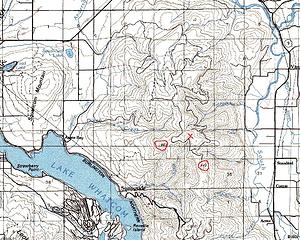 stewart mtn map
"I aint jokin woman, I got to ramble...We gonna go walkin through the park every day." - Led Zeppelin
"I aint jokin woman, I got to ramble...We gonna go walkin through the park every day." - Led Zeppelin
|
| Back to top |
|
|
Eric
Peak Geek
Joined: 21 Oct 2002
Posts: 2062 | TRs | Pics
Location: In Travel Status |
|
Eric
Peak Geek
|
Tue Dec 09, 2008 10:18 am |
|
|
Whacme does sound like a bushwhack but there are good roads to within a couple hundred feet of the top. The summit is a flattish recently logged area that is full of stumps when I did it 02/2007. I'm sure the top will be an ugly brushbash in a decade but for now it is open. The summit logging does allow for good views over to Baker and Twin Sisters.
| Quote: | | I want to go where the red Xs are in the map above. |
I am only seeing one Red X but it appears to be where I believe Stewart Mtn is located.
Attached is a little TOPO markup of the area that may be helpful.
|
| Back to top |
|
|
yew
non-technical
Joined: 12 Dec 2005
Posts: 1173 | TRs | Pics
Location: Bellingham |
|
yew
non-technical
|
Sun Jun 21, 2009 9:30 am update on Stewart Mtn powerline corridor road -mid June 2009
|
|
|
Update 6/16/09
As mentioned on Elvis's trip report, there's a new trail that runs from the new clearcut down below to MP 0.6 on the powerline corridor road.
There was a mountain biker on this road. We encountered him again on another brand spanking new trail above the new clearcut, just west of the road.
He said he and a few friends built this trail recently without the permission of DNR. It's quite a well done trail, dug into the hillside in spots. It looks official and done professionally although a bit too steep in short sections. I don't think DNR will do anything will do anything about this illegally constructed trail. They don't really have any control over their lands or what people do to them. The new, unauthorized trail above the clearcut is maybe 1 mile long (??) and the new unauthorized trail below maybe 1.25 miles (??) long.
Also, the gate to the powerline corridor road above the North Shore Whatcom Lake trailhead was open. There was a kid in a car and 2 kids on dirtbikes driving on this road. I don't know if the road is now open to public motor vehicle travel now or if the gate is closed seasonally (??).
----------------------------
Also...
We bagged Whacme Peak back in May. The route is just like what Elvis and Eric describes. Great view of Twin Sisters and the geography of the South Fork Nooksack and the valley around Kendall.
"I aint jokin woman, I got to ramble...We gonna go walkin through the park every day." - Led Zeppelin
"I aint jokin woman, I got to ramble...We gonna go walkin through the park every day." - Led Zeppelin
|
| Back to top |
|
|
|
|
You cannot post new topics in this forum
You cannot reply to topics in this forum
You cannot edit your posts in this forum
You cannot delete your posts in this forum
You cannot vote in polls in this forum
|
Disclosure: As an Amazon Associate NWHikers.net earns from qualifying purchases when you use our link(s). |


