| Previous :: Next Topic |
| Author |
Message |
Joey
verrry senior member


Joined: 05 Jun 2005
Posts: 2799 | TRs | Pics
Location: Redmond |
|
Joey
verrry senior member
|
 Tue May 05, 2009 5:36 pm |
|
|
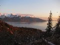
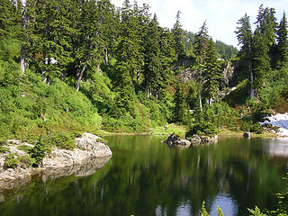
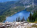
Yesterday I posted some pics in the Name that lake thread. Dayhike Mike and Tom correctly identified the North Star Creek Pots. Since the pics were from 2006 this TR is a bit tardy. To help get your juices flowing - heres a rerun of the pics plus a couple more.
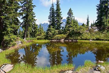 North Star Creek Pots - tarn below lake 4,420 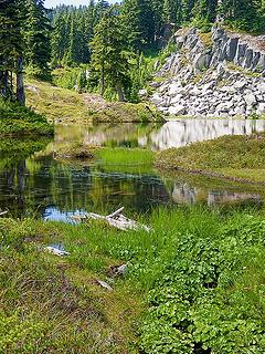 North Star Creek Pots - lake at ~4,420 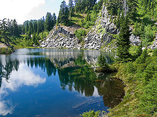 North Star Creek Pots - lake at ~4,420 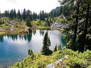 North Star Creek Pots - lake at ~4,420 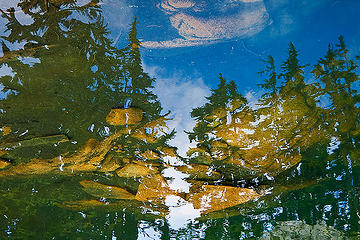 Pot peering 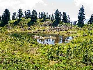 North Star Creek Pots - tarn above lake 4,420 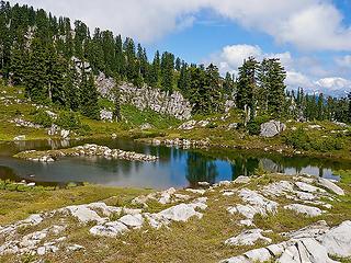 North Star Creek Pots - tarn above lake 4,420 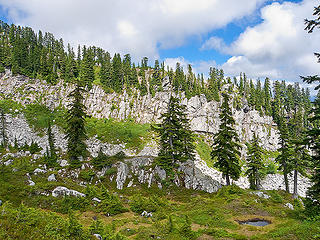 Above the larger Pots
|
| Back to top |
  
|
|
Backpacker Joe
Blind Hiker

Joined: 16 Dec 2001
Posts: 23956 | TRs | Pics
Location: Cle Elum |
Thanks Joey. Great beta.
"If destruction be our lot we must ourselves be its author and finisher. As a nation of freemen we must live through all time or die by suicide."
Abraham Lincoln
"If destruction be our lot we must ourselves be its author and finisher. As a nation of freemen we must live through all time or die by suicide."
Abraham Lincoln
|
| Back to top |
|
|
Movenhike
\m/..mmmmetal\m/
Joined: 16 Apr 2007
Posts: 642 | TRs | Pics
Location: Leavenworth, WA |
|
Movenhike
\m/..mmmmetal\m/
|
Tue May 05, 2009 7:07 pm |
|
|
Beautiful, just a couple more months....
"Make it your Friend" -John Bull
"Make it your Friend" -John Bull
|
| Back to top |
|
|
Slugman
Its a Slugfest!

Joined: 27 Mar 2003
Posts: 16874 | TRs | Pics
|
|
Slugman
Its a Slugfest!
|
Tue May 05, 2009 7:42 pm |
|
|
Excellent. With an early start and a mountain bike for the road section, this looks very doable as a dayhike or a single-night BP. Thanks. 
|
| Back to top |
|
|
Tom
Admin
Joined: 15 Dec 2001
Posts: 17857 | TRs | Pics
|
|
Tom
Admin
|
Tue May 05, 2009 8:03 pm |
|
|
IMO, it's not worth the effort now with the gate. Before the gate it was probably a toss up. Only reason I'd want go back is to visit Dollar Lakes but it's not very high on my list. The real adventure is driving thru Reiter Road on the way in and out - quite the culture shock. A first timer would probably think they stumbled onto the set of Beyond Thunderdome.
|
| Back to top |
|
|
Schroder
Member

Joined: 26 Oct 2007
Posts: 6722 | TRs | Pics
Location: on the beach |
|
Schroder
Member
|
Tue May 05, 2009 8:07 pm |
|
|
You could go in from Index for a variation in culture shock... 
|
| Back to top |
|
|
Dayhike Mike
Bad MFKer

Joined: 02 Mar 2003
Posts: 10958 | TRs | Pics
Location: Going to Tukwila |
Ditto Tom's comment. If there's an extra 4 mile road walk at the start and finish, I'm not sure I'd be all that gung ho to return.
For what it's worth once you leave the trail that takes you in (flat from the road) and start heading up, the boot trail fades pretty quickly and it ends up being a combination of light brush and small mossy talus fields up STEEP slopes. Once you hit the ridgeline, it's relatively interesting route finding til you're on the main plateau.
Also, make sure you keep track of your elevation and don't miss that flat trail on the way down. It would be very easy to go too far left (toward the creek) and drop a ways past the route home before you realize you've gone too far. No fun to regain elevation on steep and brushy slopes.
"There is only one basic human right, the right to do as you damn well please. And with it comes the only basic human duty, the duty to take the consequences." -P.J. O'Rourke
"Ignorance is natural. Stupidity takes commitment." -Solomon Short
"There is only one basic human right, the right to do as you damn well please. And with it comes the only basic human duty, the duty to take the consequences." -P.J. O'Rourke
"Ignorance is natural. Stupidity takes commitment." -Solomon Short
|
| Back to top |
|
|
Slugman
Its a Slugfest!

Joined: 27 Mar 2003
Posts: 16874 | TRs | Pics
|
|
Slugman
Its a Slugfest!
|
Tue May 05, 2009 8:15 pm |
|
|
I've never driven an inch on Reiter road.  I happen to crave scattered, tiny lakes like these the way sore feet craves waterfalls. Cutthroat lakes near-ish to Mt Pilchuck is one of my favorite places. So, even if it is "not worth it", I think I will go anyway. I'll probably spend the night up there so I can milk the area of all its juice in one trip.
|
| Back to top |
|
|
captain jack
Serving suggestion

Joined: 25 May 2004
Posts: 3389 | TRs | Pics
Location: Upper Fidalgo |
| Tom wrote: | | The real adventure is driving thru Reiter Road on the way in and out - quite the culture shock. A first timer would probably think they stumbled onto the set of Beyond Thunderdome. |
 Two men enter, one man leave !
Hey Slug
Two men enter, one man leave !
Hey Slug
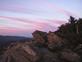
 Cutthroat Lakes - Sharpe park 009  You go out to the end of that finger and you can look straight across at the falls from the upper lake, which are behind the trees on the rock face in this picture.
I dont think anyone has been there since I schlepped in. Bears are probably lovin it, there used to be crowds up there on a sunny summer weekend, now its just four legged trail users.
You go out to the end of that finger and you can look straight across at the falls from the upper lake, which are behind the trees on the rock face in this picture.
I dont think anyone has been there since I schlepped in. Bears are probably lovin it, there used to be crowds up there on a sunny summer weekend, now its just four legged trail users.
|
| Back to top |
|
|
GeoHiker
Rocky Walker

Joined: 26 Feb 2005
Posts: 6033 | TRs | Pics
Location: Off the Deep End |
|
GeoHiker
Rocky Walker
|
Tue May 05, 2009 10:45 pm |
|
|
| Tom wrote: | | IMO, it's not worth the effort now with the gate. Before the gate it was probably a toss up. Only reason I'd want go back is to visit Dollar Lakes but it's not very high on my list. The real adventure is driving thru Reiter Road on the way in and out - quite the culture shock. A first timer would probably think they stumbled onto the set of Beyond Thunderdome. |
Stay out of there if you have any adversity to 4x4's and ORV's. It's one of the few places left in W.WA where they can do their thing. I'll second and third what Tom and DHM said. It's a nice area to check out and wander, but really not worth the effort. Now that's it's in the Wilderness it will no doubt get over run with great expectations that surely don't live up to wilderness. It's far too close to all the logging and ORV action to be designated as wilderness, but that's another thread.
BTW, I would not leave a vehicle you cared about parked at the gate.
You call some place paradise, kiss it goodbye......Eagles
You call some place paradise, kiss it goodbye......Eagles
|
| Back to top |
|
|
borank
Lake dork
Joined: 16 Dec 2001
Posts: 640 | TRs | Pics
Location: Evert |
|
borank
Lake dork
|
Tue May 05, 2009 11:11 pm |
|
|
I've had the misfortune of walking the road all the way out to the highway and part-way to Startup when we dropped down the hill from these pots in '72 and found my buddy's car on blocks and the rear wheels missing.  
|
| Back to top |
|
|
Layback
Cascades Expatriate

Joined: 16 Mar 2007
Posts: 5712 | TRs | Pics
Location: Back East |
|
Layback
Cascades Expatriate
|
Tue May 05, 2009 11:16 pm |
|
|
Beautiful Joey. Thanks for sharing that.
|
| Back to top |
|
|
Dayhike Mike
Bad MFKer
Joined: 02 Mar 2003
Posts: 10958 | TRs | Pics
Location: Going to Tukwila |
Ouch, borank. Sorry to hear it...that's a loooong walk out.
"There is only one basic human right, the right to do as you damn well please. And with it comes the only basic human duty, the duty to take the consequences." -P.J. O'Rourke
"Ignorance is natural. Stupidity takes commitment." -Solomon Short
"There is only one basic human right, the right to do as you damn well please. And with it comes the only basic human duty, the duty to take the consequences." -P.J. O'Rourke
"Ignorance is natural. Stupidity takes commitment." -Solomon Short
|
| Back to top |
|
|
Justus S.
Member

Joined: 17 Nov 2004
Posts: 1298 | TRs | Pics
Location: WA |
Cool Joey! Thanks for the TR.  Brought back my trip to the area in sept 05. I got in when the gate was still open since they were still working on the towers. I didn't take many pics of the tarns so nice to see yours. One of my few tarn pics. Brought back my trip to the area in sept 05. I got in when the gate was still open since they were still working on the towers. I didn't take many pics of the tarns so nice to see yours. One of my few tarn pics.
|
| Back to top |
|
|
Joey
verrry senior member
Joined: 05 Jun 2005
Posts: 2799 | TRs | Pics
Location: Redmond |
|
Joey
verrry senior member
|
Wed May 06, 2009 6:24 am |
|
|
Nice tarn pic Justus. Too bad the season is so short when the snow is gone and we can visit places like this.
I've been to the Pots 4 times over the years. Good news - my ride has been intact at the end of each trip. Bad news - Due either to lack of time or lack of interest among the party I never made it up to the ridge crest.
|
| Back to top |
|
|
|
|


