| Previous :: Next Topic |
| Author |
Message |
JimK
Member


Joined: 07 Feb 2002
Posts: 5606 | TRs | Pics
Location: Ballard |
|
JimK
Member
|
 Mon Jun 29, 2009 10:31 am |
|
|
Here is my report on a fun trip exploring an abondoned section of trail. Flowers, snow, a summit, and some interesting route finding.
Even more photos are here: Green Mountain Photos
The Suiattle River Road washed out at Downey Creek in 2003. The last few miles required walking or biking. In 2006 the road washed out again, this time 8 1/2 miles before Downey Creek. In 2007 Kim and I road bikes to the end of the road and hiked up Sulphur Mountain. On the way we stopped at Downey Creek and looked for the long abandoned lower part of the Green Mountain Trail. The current trailhead is nearly six miles up a logging road leaving only four miles to the summit of Green Mountain. With the road in place the lower trail was abandoned and has seen little use for the last 45+ years. We found two outhouses and a few cut logs but the route soon ended where Downey Creek took out the hillside. We thought seriously about coming back sometime to try to hike the old trail.
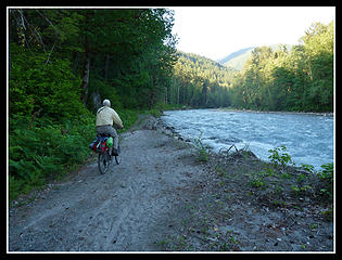
This spring Kim brought up the idea again and we planned to give it a shot. She chose the weekend of her birthday for the adventure. Randy Schroder, another nwhiker member, joined us. We headed out of Seattle on Friday afternoon. We headed through Darrington and north to the Suiattle River Road. The washout is at about 12 1/2 miles. There we found a half dozen vehicles including Randy's. We had overnight packs including ice axes. Randy managed to mount his pack on his backrack. Kim and I had boxes on our racks for boots and to support our packs to relieve the weight. The arrangements worked pretty well.
By 7:40 pm we were on our way. The road is a steady gentle climb most of the way. The worst washout now goes farther inland than the one we biked in 2007. The bad silty sections of the road were also more consolidated and much easier to bike. The biggest hill is up to the Green Mountain Road. One could bike up the nearly six miles of road to the trailhead. In my case I would likely need to walk my bike up the road. That would negate the adventure of the old abandoned trail though. Randy and I reached Downey Creek at about 9:15 and Kim soon after. We stashed our bikes near the trailhead and brought our packs across the Downey Creek Bridge to the campgrounds. Randy marveled at how half the campground is gone. The Suiattle River channel is now much wider here.
 Randy Riding By Washout 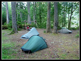 Downey Ck Campsite 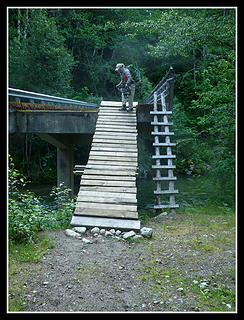 Downey Ramp 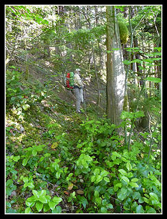 Start Of Old Trail 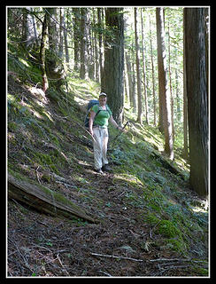 Kim On Old Tread 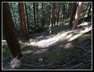 Switchbacking Up 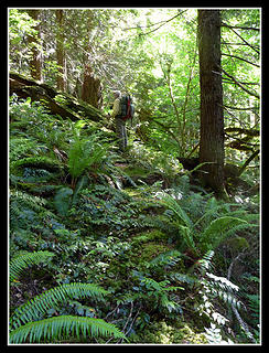 Partly Obscured 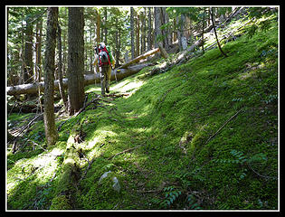 Thick Moss On Trail 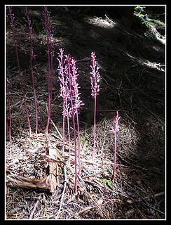 No Chlorophyll 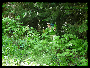 Kim Reaching Road 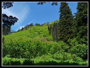 Leaving Forest 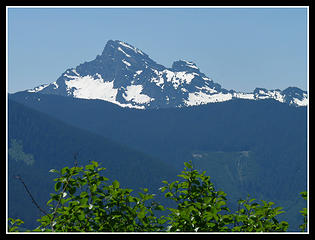 White Chuck Mountain 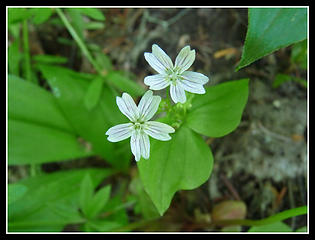 Spring Beauty 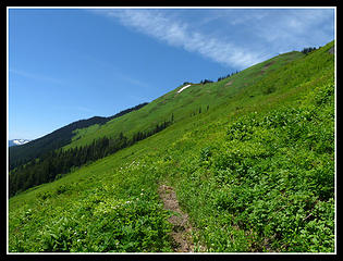 Patch Of Snow 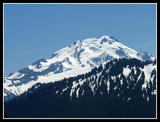 Glacier Peak Appears 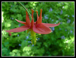 Columbine 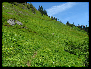 Randy In Green 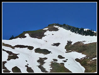 Green Mt. Summit  Lounging Around 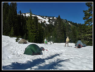 Campsite 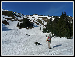 Heading For Summit 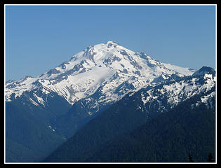 Glacier Peak 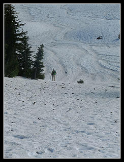 Kim Climbing 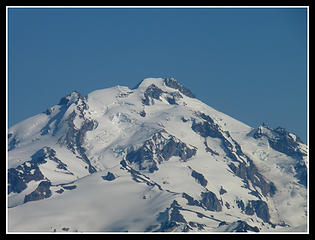 Zoomed Glacier 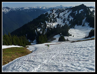 Traversing On Snow 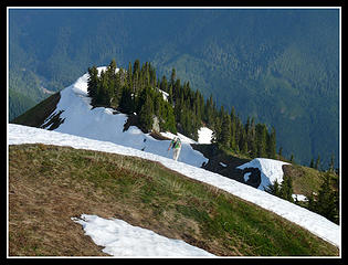 Kim Coming Up The Ridge 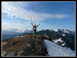 Randy On The Summit 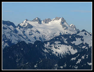 Dome Peak 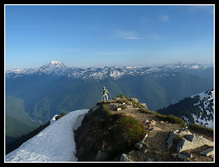 Kim Nears Summit  Bonanza Peak 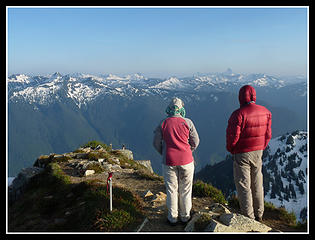 Kim & Randy On Top 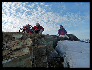 Bundled Up 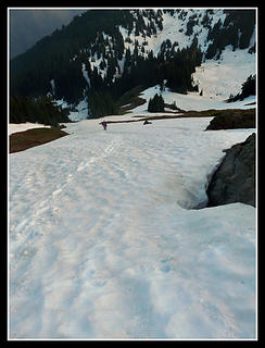 Randy Heading Down 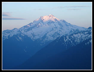 Sunset On Glacier 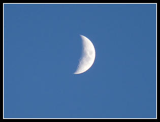 Crescent Moon 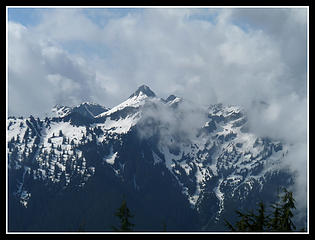 Peaks And Clouds 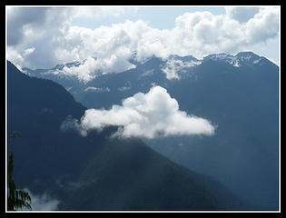 Bright Cloud 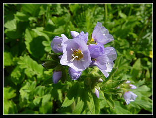 Lavender Flower 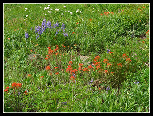 Great Color 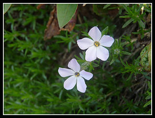 Phlox 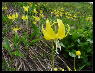 Glacier Lilies 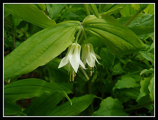 Hooker's Fairy Bells 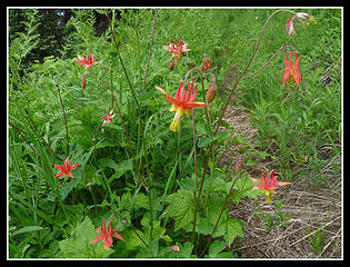 More Columbine 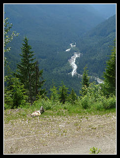 Relaxing 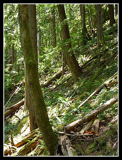 More Logs 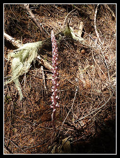 Candystick
|
| Back to top |
  
|
|
Opus
Wannabe

Joined: 04 Mar 2006
Posts: 3700 | TRs | Pics
Location: The big rock candy mountain |
|
Opus
Wannabe
|
Mon Jun 29, 2009 10:44 am |
|
|
Why oh why did you have to do this one when I was out of town!?   I've thought about that exact trip many times during the Suiattle road closure. Sounds like an awesome trip, cant wait for some photos. I've thought about that exact trip many times during the Suiattle road closure. Sounds like an awesome trip, cant wait for some photos.
|
| Back to top |
|
|
JimK
Member
Joined: 07 Feb 2002
Posts: 5606 | TRs | Pics
Location: Ballard |
|
JimK
Member
|
Mon Jun 29, 2009 10:50 am |
|
|
Yes, Opus, you would have loved it. Look on the bright side. Now you know the old trail is still there.
|
| Back to top |
|
|
Jimbo
Member

Joined: 14 Feb 2005
Posts: 1558 | TRs | Pics
Location: Arlington |
|
Jimbo
Member
|
Mon Jun 29, 2009 4:24 pm |
|
|

Guns only have two enemies; rust and politicians
Guns only have two enemies; rust and politicians
|
| Back to top |
|
|
GaliWalker
Have camera will use

Joined: 10 Dec 2007
Posts: 4931 | TRs | Pics
Location: Pittsburgh |
|
GaliWalker
Have camera will use
|
Mon Jun 29, 2009 5:23 pm |
|
|
I'm so glad I managed to hike up Green Mountain when I did. I am anxiously awaiting your photos to re-live those incredible green meadows.
Edit: Just saw some in the "Picture of the day" thread.  Very nice report. I can imagine the lovely moss on the old trail...6in?...wow!
|
| Back to top |
|
|
Quark
Niece of Alvy Moore

Joined: 15 May 2003
Posts: 14152 | TRs | Pics
|
|
Quark
Niece of Alvy Moore
|
Mon Jun 29, 2009 8:33 pm |
|
|
Sulphur Mtn awaits. 
"...Other than that, the post was more or less accurate."
Bernardo, NW Hikers' Bureau Chief of Reporting
"...Other than that, the post was more or less accurate."
Bernardo, NW Hikers' Bureau Chief of Reporting
|
| Back to top |
|
|
Hamster
Member

Joined: 24 Dec 2008
Posts: 9 | TRs | Pics
Location: Everett |
|
Hamster
Member
|
Mon Jun 29, 2009 9:16 pm |
|
|
|
| Back to top |
|
|
Schroder
Member

Joined: 26 Oct 2007
Posts: 6723 | TRs | Pics
Location: on the beach |
|
Schroder
Member
|
Tue Jun 30, 2009 8:10 pm |
|
|
Very nice photos Jim
|
| Back to top |
|
|
JimK
Member
Joined: 07 Feb 2002
Posts: 5606 | TRs | Pics
Location: Ballard |
|
JimK
Member
|
Tue Jun 30, 2009 8:15 pm |
|
|
Photos are now at the top of this thread.
|
| Back to top |
|
|
Quark
Niece of Alvy Moore
Joined: 15 May 2003
Posts: 14152 | TRs | Pics
|
|
Quark
Niece of Alvy Moore
|
Tue Jun 30, 2009 8:30 pm |
|
|
Wow, Jim, you really have some nice shots there. Incredible zoom photos. My photo mojo wasn't on, I guess; not very many of my mountain photos turned out. I like your old tread photos as well.
Randy seems to have done a lot of relaxing on this trip. There are a few photos of him in the warm sunshine not doing a goddamn thing. 
"...Other than that, the post was more or less accurate."
Bernardo, NW Hikers' Bureau Chief of Reporting
"...Other than that, the post was more or less accurate."
Bernardo, NW Hikers' Bureau Chief of Reporting
|
| Back to top |
|
|
Schroder
Member
Joined: 26 Oct 2007
Posts: 6723 | TRs | Pics
Location: on the beach |
|
Schroder
Member
|
Tue Jun 30, 2009 8:31 pm |
|
|
|
| Back to top |
|
|
Magellan
Brutally Handsome

Joined: 26 Jul 2006
Posts: 13117 | TRs | Pics
Location: Inexorable descent |
|
Magellan
Brutally Handsome
|
Tue Jun 30, 2009 9:51 pm |
|
|
|
| Back to top |
|
|
peltoms
Member

Joined: 13 Jul 2006
Posts: 1760 | TRs | Pics
Location: Worcester MA |
|
peltoms
Member
|
Wed Jul 01, 2009 3:41 am |
|
|
Great trip, mossy trail, washout, moonshot, Dakobed looming and all to yourselves, thanks for sharing.
|
| Back to top |
|
|
Foist
Sultan of Sweat

Joined: 08 May 2006
Posts: 3974 | TRs | Pics
Location: Back! |
|
Foist
Sultan of Sweat
|
Wed Jul 01, 2009 8:26 am |
|
|
Really really really nice.
|
| Back to top |
|
|
Lono
Member
Joined: 19 May 2006
Posts: 930 | TRs | Pics
|
|
Lono
Member
|
Wed Jul 01, 2009 10:33 am |
|
|
Wow, when did the Downey Ramp get put in? May help a bit with getting on to Sulphur Creek TH, or does anyone know are there more washouts beyond?
I remember going up the old trail to Green Mountain as a little boy with my older brother and friends, I distinctly recall the wooded section was almost like a fairy tale, and I felt like we were in a scene from Sound of Music when we got to where it opened up. Its a really great trail, I'm glad you can still find it.
|
| Back to top |
|
|
|
|


