| Previous :: Next Topic |
| Author |
Message |
SeanSullivan86
Member


Joined: 25 Jul 2009
Posts: 681 | TRs | Pics
Location: Seattle, WA |
I had a nice hike on Snoqualmie Mountain today, but I'm thinking I didn't really get to the real summit. There's 3 different high points. If ascending from the Snow Lake Trailhead on the normal trail, you first reach the lowest of the 3 summits, which I'll call the 'false summit'. To the west the trail continue another 100 yards to a higher bump, which I'll call the 'easy summit'. To the north of the false summit there's a challenging-looking ridge with a spire I'll call the 'hard summit'.
So as I'm sitting on the easy summit looking over to the hard summit, it looks like its probably higher. I put my eye at the level of the highest point of the easy summit and look towards the hard summit. It looks to be about level with a bump on the horizon to the east of Mt. Stuart. From my photos, seems to me like this is Hawkins Mountain (7160'). That makes it about 1 degree up from the easy summit to the hard summit, or 5+ feet higher.
So I tried to get over to the hard summit, but I'm not really much of a scrambler yet and turned back when the vertigo became too much to handle. Here's a photo looking from the false summit to the hard summit.
Anyways, I dont care that much. The easy summit is good enough for me, just curious as I didn't see it mentioned that this ridge is probably higher than the high point on the trail. Anyone been over there via the ridge from the false summit? How hard is it? Seemed to me like class 4.
|
| Back to top |
  
|
|
Tom
Admin
Joined: 15 Dec 2001
Posts: 17857 | TRs | Pics
|
|
Tom
Admin
|
 Sat Jul 25, 2009 5:20 pm |
|
|
I'm pretty sure the "easy" summit is the true summit.
|
| Back to top |
|
|
puzzlr
Mid Fork Rocks

Joined: 13 Feb 2007
Posts: 7220 | TRs | Pics
Location: Stuck in the middle |
|
puzzlr
Mid Fork Rocks
|
Sat Jul 25, 2009 5:34 pm |
|
|
Good topic. I agree with Tom -- the standard top looked higher to me when I was there. But I've always wanted to get over to that other summit -- next time I'll try for it and look back.
|
| Back to top |
|
|
SeanSullivan86
Member
Joined: 25 Jul 2009
Posts: 681 | TRs | Pics
Location: Seattle, WA |
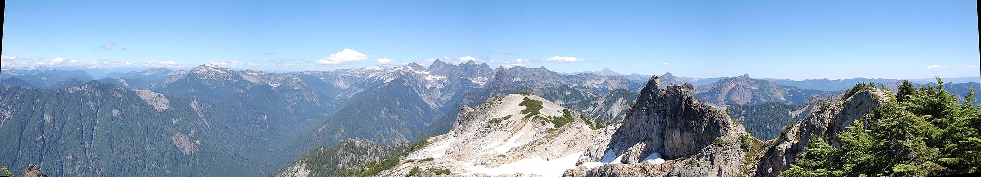
Here's a photo I took with the camera resting on the high point of the easy summit looking towards the hard summit. The rock to the right is the hard summit. The mountain just to the left of it is Hawkins, I think. Since Hawkins (7160') is a lot higher than Snoqualmie Mountain (6278'), if they look evenly high in the photo then wouldn't the hard summit be higher than the easy summit? By my estimates, if the hard summit was level with about 6600' on Hawkins, then the easy and hard summit would be the same height.
And here's another photo from the easy summit showing the hard summit at the right and stuart in the center. Used this to identify the bump on the horizon between them as Hawkins. Hawkins looks higher now because I'm standing on the summit holding the camera, instead of the camera resting on the summit.
|
| Back to top |
|
|
Tom
Admin
Joined: 15 Dec 2001
Posts: 17857 | TRs | Pics
|
|
Tom
Admin
|
Sat Jul 25, 2009 6:24 pm |
|
|
I'm not exactly sure what you're saying but one potential flaw is that your pics may not be level. The clouds appear to be sloping down to the left in the first pic, so I'm not sure you could conclude anything from the pictures unless you shot with a level and/or accounted for potential lens distortion.
|
| Back to top |
|
|
sky_pilot
Member
Joined: 29 Apr 2009
Posts: 55 | TRs | Pics
Location: Seattle |
Not sure which summit is higher. Ragman and Rodman posted a spectacular photo of an unknown climber on the false summit here:
http://rgervin.com/photos2008/20081001MtSnoqualmie/original/PA010031.html
I found it to be much more enjoyable to scramble to the false summit. Near 4700 feet where the climbers trail comes out of the woods and heads north up the S Ridge, leave the trail and continue up the open basin to the NE. This gives easy access to the EW ridge between Snoqualmie and Lundin. The false summit is a simple class 2 scramble from E to W. I wanted to traverse it, but one look over the edge and I knew I had to turn back the way I came.
A few photos of the route:
meadow skipping toward the false summit.
 False Summit 10.01.08 043.jpg  False Summit 10.01.08 049.jpg  False Summit 10.01.08 052.jpg 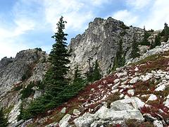 False Summit 10.01.08 069.jpg
|
| Back to top |
|
|
Tom
Admin
Joined: 15 Dec 2001
Posts: 17857 | TRs | Pics
|
|
Tom
Admin
|
Sat Jul 25, 2009 7:10 pm |
|
|
That's a sweet shot. 
|
| Back to top |
|
|
Mtn Dog
Technohiker

Joined: 01 Aug 2004
Posts: 3336 | TRs | Pics
Location: Bellevue, WA |
|
Mtn Dog
Technohiker
|
Sat Jul 25, 2009 7:36 pm |
|
|
If you look close enough at the rock formation in the center of the "easy" summit, where the climber trail ends, you'll see a small 1" diameter semicircle which used to hold the USGS Triangulation Station brass disk. The rock fractured due to years of freeze/thaw cycles and the disk is no longer there. The USGS usually places these on the true summit and if you look to the north about 40-50' just before the ledge, you'll still see the only USGS reference mark preserving the station's location.
When I was there I saw a lone hiker scramble the rock formation to the east. While he was climbing it he missed seeing the only mountain goat in the area at the time.
Footprints on the sands of time will never be made sitting down.
Footprints on the sands of time will never be made sitting down.
|
| Back to top |
|
|
Justus S.
Member
Joined: 17 Nov 2004
Posts: 1298 | TRs | Pics
Location: WA |
I do remember scrambling from the normal summit to the craggy one. I also remember that I didn't want to fall. It was cloudy out so I couldn't judge as to which was the higher summit.
|
| Back to top |
|
|
belowfellow
Transplant

Joined: 22 Feb 2009
Posts: 261 | TRs | Pics
Location: Seattle |
I did the east peak and true summit a few days before I broke my foot. I thought that the middle spire looked higher as well. This pic was taken from the east peak.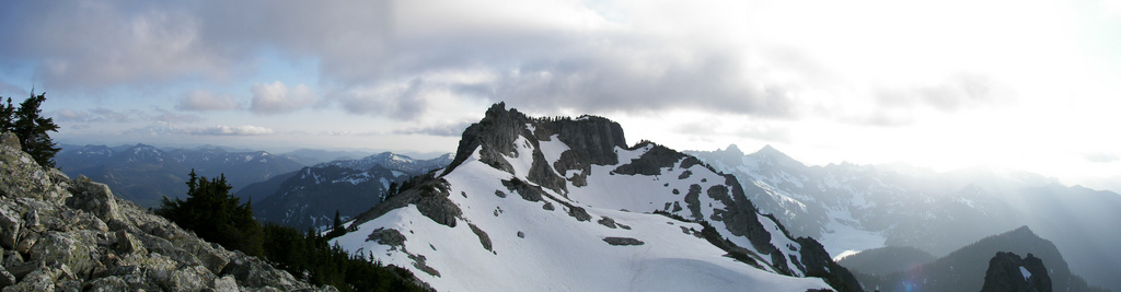 6-26-09-Snoq Mtn Summit from East Peak
|
| Back to top |
|
|
Mtn Dog
Technohiker
Joined: 01 Aug 2004
Posts: 3336 | TRs | Pics
Location: Bellevue, WA |
|
Mtn Dog
Technohiker
|
Sun Jul 26, 2009 3:08 pm |
|
|
Here's a view of the ALW looking east from the true summit. The rocky crag doesn't look that high (keeping in mind that Big Snow Mtn in the background only rises to 6,680'). The first rise from the Climber's trail is also shown above the trees.
 Looking east from summit
Footprints on the sands of time will never be made sitting down.
Footprints on the sands of time will never be made sitting down.
|
| Back to top |
|
|
Malachai Constant
Member

Joined: 13 Jan 2002
Posts: 16097 | TRs | Pics
Location: Back Again Like A Bad Penny |
I am pretty sure the easy summit is higher. The rocky crag is not that hard to get to as several have done that on TNAB hikes.
Since the Mounties have been going there since the 1920's the peak would have a register and a path if it were the true summit, Beckey says to go underneath on the east route and he would not do so if it were the true summit.
"You do not laugh when you look at the mountains, or when you look at the sea." Lafcadio Hearn
"You do not laugh when you look at the mountains, or when you look at the sea." Lafcadio Hearn
|
| Back to top |
|
|
solohiker
Member
Joined: 23 Jan 2004
Posts: 1081 | TRs | Pics
Location: issaquah |
As NWH monitor Tom points out, there are a lot of flaws in using a camera and line of site to determine which peak is higher. My first few trips up there I also thought the rocky crag to the right (east) of the first summit was the highest point, but then I noticed the USGS marker on the summit to the left (west) and managed to convince myself that an optical illusion makes the crags seem higher because they are so narrow. In fact if it's important enough to you to look at your topo-map, you'll note the west peak is indeed highest.
As another example of an optical illusion right in the same neighborhood - Cave Hole Ridge is actually higher than Guye Peak, but you certainly can't tell that by looking - the narrow top of Guye makes it look higher than the large flat top of Cave Hole, and speaking of Guye - when you arrive at the north peak, it looks like you're looking up at the top of the south peak, but if you climb over to the south peak it looks like you're looking up at the north peak where you had just been. Eyes are deceiving.
FWIW Dicey posted a pix a few years ago of her hiking parner on top of the crag.
I have never been lost, but I'll admit to being confused for several weeks. - Daniel Boone
I have never been lost, but I'll admit to being confused for several weeks. - Daniel Boone
|
| Back to top |
|
|
SeanSullivan86
Member
Joined: 25 Jul 2009
Posts: 681 | TRs | Pics
Location: Seattle, WA |
Thanks for the replies everyone. Malachai and solohiker, I got to about where those people are standing in your pics as well. The crag further to the right (northeast) is higher though.
Mtn Dog... you may have been holding the camera at a normal height (5 feet) when you took the photo. As the 2 summits are about 200 yards apart, it would make the hard summit look about 0.5 degrees lower on the horizon if you held the camera in the air. So it makes a 440 foot difference on the mountains 10 miles away.
I'm just saying it looks pretty close to me. The photo I posted with Hawkins is evidence that its close, no? Do you think that if the camera is level in that photo then it would mean the hard summit is higher?
Hmm ok, here's the photo with some lines drawn on it. I doubt I twisted the camera that much, but I guess its always possible, especially without having the whole horizon to aim at.
The way I see it, if the hard summit is at the same level as 6530' on Hawkins, then the 2 summits are roughly the same height. If the hard summit looks higher than 6530' on Hawkins, they the hard summit is maybe higher than the easy summit.
A table (maybe I cant do math):
Height on Hawkins / Angle (degrees) / difference in hard and easy summit (feet):
5630 -0.5 -5.2
5810 -0.4 -4.2
5990 -0.3 -3.1
6170 -0.2 -2.1
6350 -0.1 -1.0
6530 0 0
6710 0.1 1.0
6890 0.2 2.1
7070 0.3 3.1
|
| Back to top |
|
|
Mtn Dog
Technohiker
Joined: 01 Aug 2004
Posts: 3336 | TRs | Pics
Location: Bellevue, WA |
|
Mtn Dog
Technohiker
|
Sun Jul 26, 2009 8:21 pm |
|
|
I provided the pano because it's another different view of the same outcropping. It does show that Snoqualmie Mtn is definitely higher than Lundin Peak. It also shows that the first top you come to on the right of the photo is also at about the same height, at least from this viewpoint, and you know when you hike it that it's lower than the west summit.
Footprints on the sands of time will never be made sitting down.
Footprints on the sands of time will never be made sitting down.
|
| Back to top |
|
|
|
|


