| Previous :: Next Topic |
| Author |
Message |
Tom_Sjolseth
Born Yesterday


Joined: 30 May 2007
Posts: 2652 | TRs | Pics
Location: Right here. |
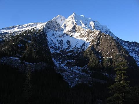
Justus_S drove up to the Mountain Loop Highway before work this past week, and took some photos of the N Face of Big Four. It looked like it could be in climbing shape given the great snow conditions and clear weather, but we weren't sure about the portion down low, so we were intent to check it out ourselves.
Justus, therunningdog, and I left Seattle at 1:30AM this morning and drove to the parking area for Big Four Ice Caves. We walked out and looked at the North Face, basking in the bright moonlight. Although the upper portion of the face looked great, the lower face where polished slabs guard the way was absent of snow. We decided to check out a route up Dry Gulch that crosses over into the bowl below the upper half of the N Face. This would enable us to bypass the tricky lower portion of the face in the dark.
We arrived at milepost 27 off the Mtn Loop at about 3:15AM. After 30 minutes of packing up our gear and remarking how cold it was, we were off. We headed downhill to cross the river, 'schwacking through brush in the dark. Once at the river, we could not find a suitable crossing right away, and so we headed up stream to find one. About a half mile later, we stumbled upon a suitable log (albeit iced over). Carefully, we made our way across without incident.
From the river crossing, we headed up the hill in slide alder and devils clubs (still dark), aiming for the waterfall. Once at the waterfall, it was very tough to see the route, especially since the moon was crossing over the top of the peak and out of view. We poked around for about an hour or so, trying different variations through iced-over cliff bands, but eventually gave up and waited for sunrise.
When the sun came up enough for us to see clearly, we spied a gully to climber's right that heads up into the basin below the Dry Gulch route. We climbed this gully about 600' to a leftward trending diagonal ramp. This ramp was great, because it offered us practically the only route up into the basin.
Once in the basin, we traversed climber's left, then straight up into an avalanche cone coming off the E Face. From there, we cut right up another steep, diagonal snow ramp that enabled us to gain the bowl below the upper N Face of Big Four. We had not heard of anyone going this way before, but Justus spied it in hi-res photos and we figured it would go.
The ramp leads into some very steep terrain (65 degrees) with very large drops below. The snow was perfect though, and so we felt fairly comfortable through here. Perfect styrofoam!
At the end of the ramp, we cut straight uphill and gained a large saddle below Pt 4720+. From here, we could see the remainder of the route. 1500' of steep, beautiful ice leading right up to the true summit.
We didn't belay any of the final pitches, but rather did running belays with me leading (tied into the middle of the rope) and Tim and Justus following (tied into the ends, staggered). I placed a total of 8 screws on the entire 1500', and slung about 4 trees. Other than that, all the sticks were bomber, so we felt pretty good about things.
We topped out at 1PM, just as we had guessed from the get-go. We made our way over to the true summit, ate some food, re-hydrated, took some photos, then headed down to find the Dry Gulch route and descend.
The descent was steep in places, and we had to down-climb one vertical WI pitch (15'), and several 80 degree WI pitches. Again, the placements were all very solid, so it was very confidence inspiring.
We finally made it back to the car at 5:15, 13.5 hours after we left. What a great day in the mountains, one I will remember for a long time to come. Thanks to Justus and Tim for being such great partners. 
 Big Four's East Face at sunrise.  Tim happy to be out on such a beautiful day.  Justus starting up the access ramp.  Justus halfway up the ramp.  Pt 4760+  The upper North Face of Big Four in stellar conditions.  More of the upper North Face of Big Four.  Justus and I heading up to the first pitch.  Justus and I starting up the first pitch.  Views from mid-pitch.  Me on the first pitch.  Perfect ice.  Icicles on the North Face of Big Four.  Looking up to the remainder of the route.  Justus and Tim somewhere on the North Face.  More ice!  Tim, all smiles.  Mountain Loop peaks in the distance.  Nearing the summit of Big Four. 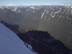 Shadow of Big Four from just below the summit.  Vesper, Sperry, and beyond from the summit of Big Four.  More summit views.  2 labels Tim and Justus traversing the summit ridge.  Me on the summit of Big Four. 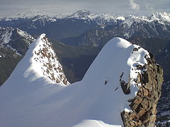 Weather moving in?  Me downclimbing from the false summit.  Justus and Tim downclimbing to the notch.  More downclimbing.  The last of the downclimbing.  Parting shot from the descent.
|
| Back to top |
  
|
|
Magellan
Brutally Handsome

Joined: 26 Jul 2006
Posts: 13117 | TRs | Pics
Location: Inexorable descent |
|
Magellan
Brutally Handsome
|
 Sat Dec 05, 2009 8:23 pm |
|
|
F-bomb! Manly men climbing manly routes. That stuff will put hair on your chest.
|
| Back to top |
|
|
twodogdad
Member

Joined: 21 Nov 2006
Posts: 846 | TRs | Pics
Location: seattle |
|
twodogdad
Member
|
Sat Dec 05, 2009 9:55 pm Re: Big Four - Dry Gulch to Upper North Face - December 5, 2009
|
|
|
Noble achievement, gentlemen.
You're very brave not to protect this traverse, perfect snow conditions notwithstanding:
| Tom_Sjolseth wrote: | Justus and Tim downclimbing to the notch. |
tdd
|
| Back to top |
|
|
Gimpilator
infinity/21M

Joined: 12 Oct 2006
Posts: 1684 | TRs | Pics
Location: Edmonds, WA |
Bad-ASS! I want Big Four in a major way but I'm not sure I'll ever be up to the task. Nice job!
|
| Back to top |
|
|
Hulksmash
Cleaning up.

Joined: 20 Apr 2008
Posts: 7113 | TRs | Pics
Location: Arlington |
|
Hulksmash
Cleaning up.
|
Sat Dec 05, 2009 9:57 pm |
|
|

"Bears couldn't care less about us....we smell bad and don't taste too good. Bugs on the other hand see us as vending machines." - WetDog
Albuterol! it's the 11th essential
"Bears couldn't care less about us....we smell bad and don't taste too good. Bugs on the other hand see us as vending machines." - WetDog
Albuterol! it's the 11th essential
|
| Back to top |
|
|
Layback
Cascades Expatriate

Joined: 16 Mar 2007
Posts: 5712 | TRs | Pics
Location: Back East |
|
Layback
Cascades Expatriate
|
Sat Dec 05, 2009 10:42 pm |
|
|
F'ing awesome you guys.
|
| Back to top |
|
|
Scrooge
Famous Grouse

Joined: 16 Dec 2001
Posts: 6966 | TRs | Pics
Location: wishful thinking |
|
Scrooge
Famous Grouse
|
Sat Dec 05, 2009 10:49 pm |
|
|
Golly, guys, all the effort and not one single pic of the avalanche cone. 
Something lost behind the ranges. Lost and waiting for you....... Go and find it. Go!
Something lost behind the ranges. Lost and waiting for you....... Go and find it. Go!
|
| Back to top |
|
|
Chief Joseph
Member

Joined: 10 Nov 2007
Posts: 7710 | TRs | Pics
Location: Verlot-Priest Lake |
Why did they use a log to cross the river when they just built a multi-million dollar bridge? Probably because of route proximity?
Go placidly amid the noise and waste, and remember what comfort there may be in owning a piece thereof.
Go placidly amid the noise and waste, and remember what comfort there may be in owning a piece thereof.
|
| Back to top |
|
|
Hulksmash
Cleaning up.
Joined: 20 Apr 2008
Posts: 7113 | TRs | Pics
Location: Arlington |
|
Hulksmash
Cleaning up.
|
Sat Dec 05, 2009 11:09 pm |
|
|
Don't worry Scrooge, i got one from today. 
"Bears couldn't care less about us....we smell bad and don't taste too good. Bugs on the other hand see us as vending machines." - WetDog
Albuterol! it's the 11th essential
"Bears couldn't care less about us....we smell bad and don't taste too good. Bugs on the other hand see us as vending machines." - WetDog
Albuterol! it's the 11th essential
|
| Back to top |
|
|
EastKing
Surfing and Hiking

Joined: 28 Mar 2007
Posts: 2082 | TRs | Pics
Location: 77 miles from Seattle! |
|
EastKing
Surfing and Hiking
|
Sat Dec 05, 2009 11:14 pm |
|
|
WOW!! Totally awesome!! Great job for you all for doing that one!
YouTube | SummitPost
Saw the depths of despair. Now I am salvaging what time I have left on Earth.
YouTube | SummitPost
Saw the depths of despair. Now I am salvaging what time I have left on Earth.
|
| Back to top |
|
|
Justus S.
Member
Joined: 17 Nov 2004
Posts: 1298 | TRs | Pics
Location: WA |
Great pictures Tom! Thanks Tom and Tim for a great day!!!
Big Four is one of those mountains that you just have to wait for the right conditions before you attempt to climb it. With the recent warm up followed by a cold spell, I had a suspicion that it might be a good time to get up it. Wednesday I went up the loop and took some pictures to study. Big Four looked in! I had initial only wanted to try the Dry Creek route but after I sent Tom some photos he managed to get me on board with maybe doing the North Face. In the process of studying pictures on nwhikers as well as my own I happened upon a possible route to access the North Face in case the standard approach didn't work out. It turned out that these events would be the key for a great day in the mountains.
Images from Wed
 4 labels Big Four and the Dry Creek Basin 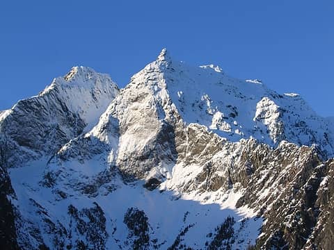 1 label Big Four and the Dry Creek basin 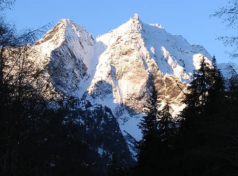 The upper Dry Creek Gully 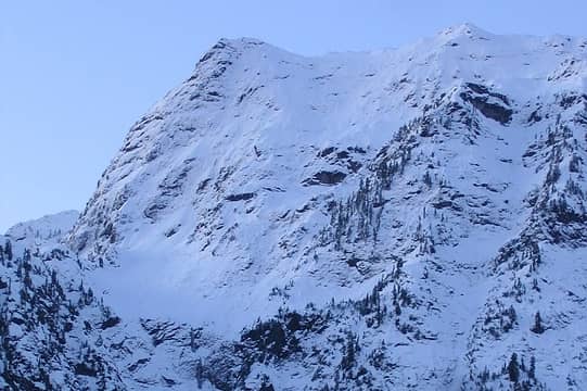 Big Four's upper North Face 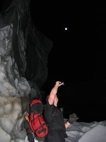 Tom, under the moon, taking photos of giant snow blocks at the base of the Dry Creek Basin 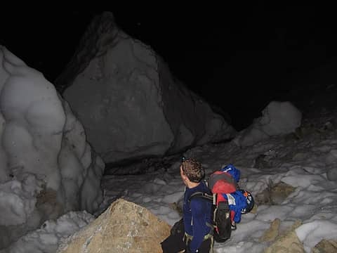 Tim checking out the giant snow blocks on the way in 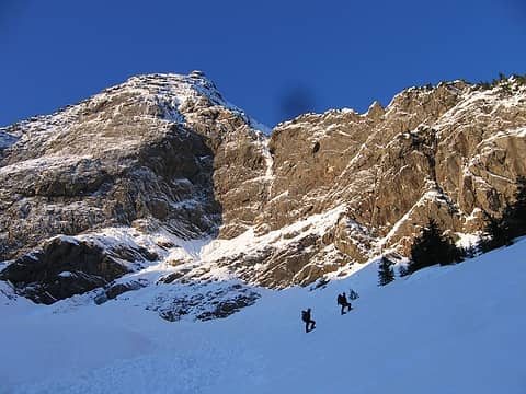 Tim and Tom climing up to the ramp 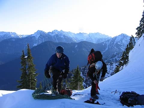 Tim and Tom prepare the gear 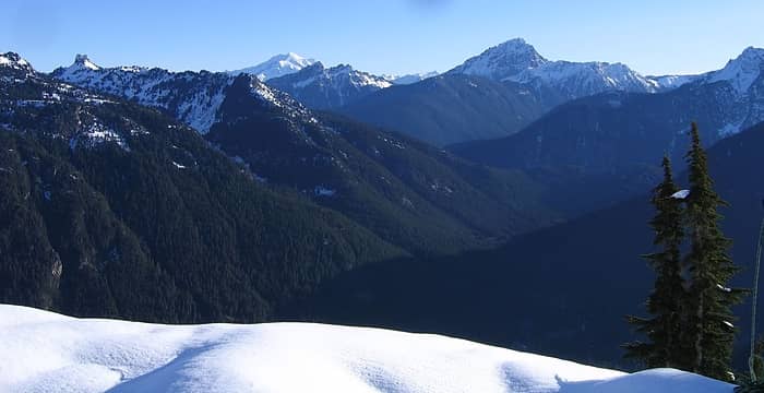 Just a wonderful day to be out on the Mtn Loop 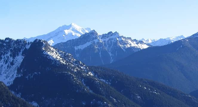 Glacier Pk 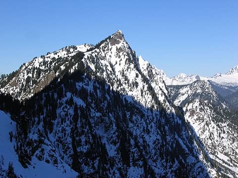 Hall Peak 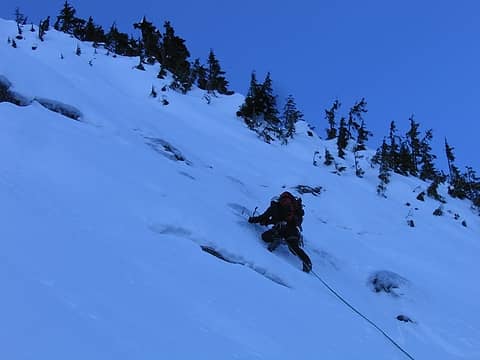 Tom climbing 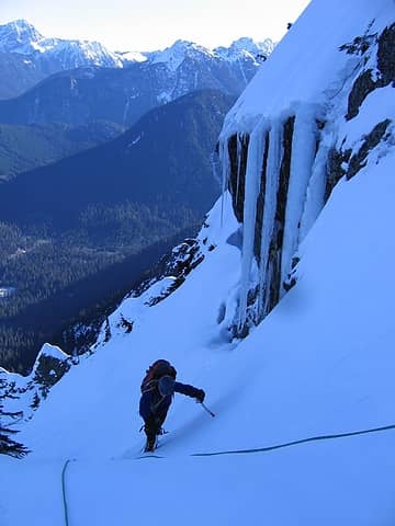 Tim climbing up 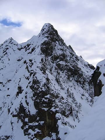 South Peak of Big Four 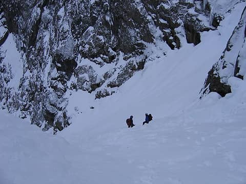 Heading down the upper Dry Creek Gully 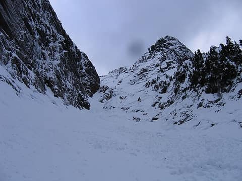 Looking back at the upper Dry Creek Gully 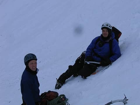 Time for a little rest 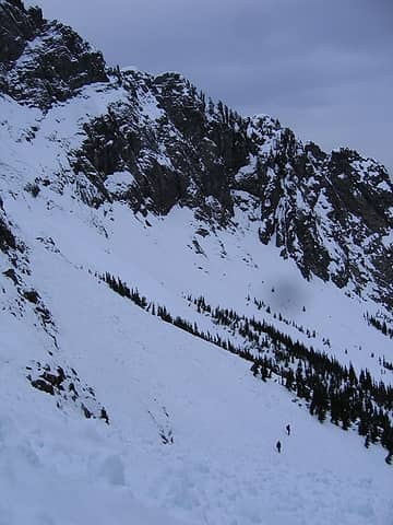 Heading out 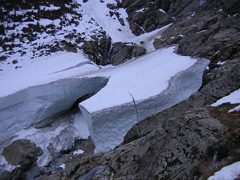 Snow blocks at the base, now with light 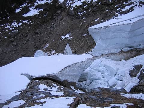 Snow blocks at the base
|
| Back to top |
|
|
Justus S.
Member
Joined: 17 Nov 2004
Posts: 1298 | TRs | Pics
Location: WA |
| Chief Joseph wrote: | | Why did they use a log to cross the river when they just built a multi-million dollar bridge? Probably because of route proximity? |
We thought about going in from the ice caves but the river crossing is a more direct alternative.
|
| Back to top |
|
|
puzzlr
Mid Fork Rocks

Joined: 13 Feb 2007
Posts: 7220 | TRs | Pics
Location: Stuck in the middle |
|
puzzlr
Mid Fork Rocks
|
Sun Dec 06, 2009 12:24 am |
|
|
Wow! Someone climbed Big Four today and I had trouble even finding the trail to Fuller Mountain. Thanks goodness you didn't leave the NWHiker summit register up there.
|
| Back to top |
|
|
peltoms
Member

Joined: 13 Jul 2006
Posts: 1760 | TRs | Pics
Location: Worcester MA |
|
peltoms
Member
|
Sun Dec 06, 2009 4:34 am |
|
|
Magnificent love the summit shadow shot and the mountain face sunrise shot. More clear and cold weather, what next 
|
| Back to top |
|
|
Jim Dockery
Member

Joined: 12 Sep 2007
Posts: 3092 | TRs | Pics
Location: Lake Stevens |
Dang, I was up there with the wife taking pics (tripod and tele) and hiking to the ice caves. Wish I'd known you guys were up there, I would have tried to get some shots of ya. Goodun on ya!! Thanks for confirming my estimate of conditions, I'm heading back up the Mt. Loop today to look around. TR to follow.
|
| Back to top |
|
|
|
|


