| Previous :: Next Topic |
| Author |
Message |
daffish
Member


Joined: 16 Sep 2009
Posts: 282 | TRs | Pics
Location: Dreamtime |
|
daffish
Member
|
 Tue May 24, 2011 8:53 pm |
|
|
Skyhomelyish Mountain 4494
What a homely name for a homely so called mountain. And a road goes almost to the top so I figured that it would make a good ski tour while the snow still was around. I had to hike a bit before I could put those skinny sticks on my feet but then I made it all the way to the summit on skis. This trip I had more normal Cascade weather; i.e. clouds, fog, mist. As I climbed higher on the road, my visibility became shorter and shorter.
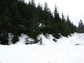 turn left to get into the clouds 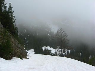 brief clearing 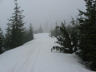 upper road somewhere 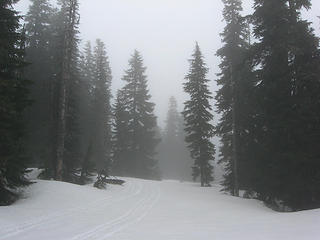 near the top 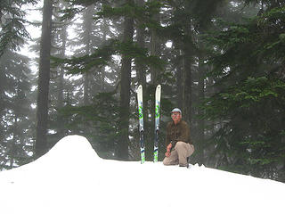 peak bagger with skis 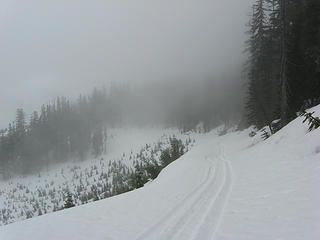 upper portion of road 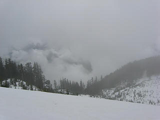 is it clearing? 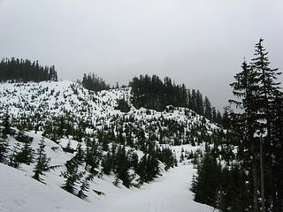 so thats what the area looks like 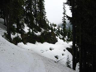 road segment 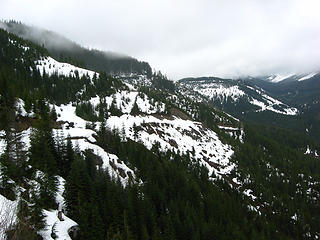 beneath the clouds and a long ski down 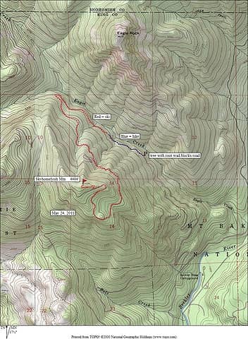 Skyhomelyish Mtn map
"Be moderate in everything, including moderation" Horace Porter
"Be moderate in everything, including moderation" Horace Porter
|
| Back to top |
  
|
|
iron
Member

Joined: 10 Aug 2008
Posts: 6392 | TRs | Pics
Location: southeast kootenays |
|
iron
Member
|
Tue May 24, 2011 9:09 pm |
|
|
hooray clouds!
is that the official name for the summit?
|
| Back to top |
|
|
Redwic
Unlisted Free Agent

Joined: 23 Feb 2009
Posts: 3292 | TRs | Pics
Location: Going to the Prom(inence) |
|
Redwic
Unlisted Free Agent
|
Tue May 24, 2011 9:13 pm |
|
|
"Tree with root wad"? (Shown on map)
So you were not able to drive any further than you had at the beginning of the month? No more snowmelt on the road, or was it just blocked by debris?
60 pounds lighter but not 60 points brighter.
60 pounds lighter but not 60 points brighter.
|
| Back to top |
|
|
daffish
Member
Joined: 16 Sep 2009
Posts: 282 | TRs | Pics
Location: Dreamtime |
|
daffish
Member
|
Tue May 24, 2011 9:25 pm |
|
|
| Quote: | | is that the official name for the summit? |
I have heard that somewhere before and that is the "official" unofficial name as it appears on Google Earth.
Eagle Creek Rd is blocked not too much farther up than what you could drive earlier this month. A little sawing could probably get you past it but a little ways past that is the cliffy area where rocks of all sizes litter the roadbed. And then the snow starts in earnest.
"Be moderate in everything, including moderation" Horace Porter
"Be moderate in everything, including moderation" Horace Porter
|
| Back to top |
|
|
Redwic
Unlisted Free Agent
Joined: 23 Feb 2009
Posts: 3292 | TRs | Pics
Location: Going to the Prom(inence) |
|
Redwic
Unlisted Free Agent
|
Wed May 25, 2011 6:21 am |
|
|
| daffish wrote: | | Quote: | | is that the official name for the summit? |
I have heard that somewhere before and that is the "official" unofficial name as it appears on Google Earth. |
That's part of the problem right there: Google Earth. Especially considering their information was garnered from an unofficial source, itself.
"Skyhomelyish Mountain" is an unofficial name. Without question. I would not doubt it if John Roper or someone in his hiking contingent named it, sometime in the past. Then that unofficial name was posted online, which was then taken by another person who then sold it to Google which then treated it as if it were an official name... so that name will probably stick now. What a wacky name, too!
But unofficial name, or official name, this peak (despite its otherwise non-technical approach and lack of killer views) is still a "true" peak and a worthy objective for some.
------------
Good job, daffish! And thanks for the useful road and route beta. 
60 pounds lighter but not 60 points brighter.
60 pounds lighter but not 60 points brighter.
|
| Back to top |
|
|
ale_capone
Member

Joined: 22 Sep 2009
Posts: 720 | TRs | Pics
|
heh,,
I was looking up at skyhomelyish on my way homelyish, thinking,, hey, there is a road going ot the top!
Clouds didn't clear til around 4 or so. Guess the sunny part of partly sunny was the afternoon. the couldy part of the forecast must have been down low, cuz rainier looked awfully clear in the web cam.
regarding the unofficial names on google maps. Noticed about a month or two ago that alot of the names where no longer on there? Am I veiwing it wrong?
|
| Back to top |
|
|
Redwic
Unlisted Free Agent
Joined: 23 Feb 2009
Posts: 3292 | TRs | Pics
Location: Going to the Prom(inence) |
|
Redwic
Unlisted Free Agent
|
Wed May 25, 2011 9:23 am |
|
|
You are correct. A lot of odd names recently disappeared from Google Earth. That is not by accident. And, from what I have heard, a lot more odd names might be disappearing in the future...
... but that is a story for another time/forum.
60 pounds lighter but not 60 points brighter.
60 pounds lighter but not 60 points brighter.
|
| Back to top |
|
|
rossb
Member

Joined: 23 Sep 2002
Posts: 1679 | TRs | Pics
|
|
rossb
Member
|
Wed May 25, 2011 5:07 pm |
|
|
Thanks for the report. I love to hear about places like this to explore. Looks like a fun ski trip. Since the road is mostly on the north side, I would imagine most of the snow will stick around a while.
|
| Back to top |
|
|
GeoHiker
Rocky Walker

Joined: 26 Feb 2005
Posts: 6033 | TRs | Pics
Location: Off the Deep End |
|
GeoHiker
Rocky Walker
|
Thu May 26, 2011 5:15 pm |
|
|
That's a nice area to hike/explore with some excellent views. I was camping near the 4,000 ft. level last year the first week of June and there were only patches of snow left. I have a feeling this year might be a bit different...... Here's what it looks like when you can see. Here's what it looks like when you can see.
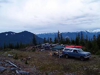 Camping near Eagle Creek, 4,000 ft.
You call some place paradise, kiss it goodbye......Eagles
You call some place paradise, kiss it goodbye......Eagles
|
| Back to top |
|
|
Fred Beavon
Member
Joined: 24 Mar 2005
Posts: 48 | TRs | Pics
Location: Edmonds, WA |
Yes, thanks for the report. Your ski tracks were still visible today, Sunday, June 5. It took me 2 and 1/2 hours up also. 1 and 1/2 hours down, taking a big shortcut in that clearcut area near the top that's starting to grow back now. You got a good picture of it. Not having skis, I just booted it up.
The only thing that would've made my trip better was if I'd left my ice axe, snowshoes, jeans, flannel shirt and jacket in the car. None of that extra weight was needed. It was t-shirt and shorts weather right from the car. Gaitors were helpful, though.
That root wad can now be driven around, but there is one medium sized boulder that soon blocks all passage, along with many smaller rocks, too, as you mentioned. But snow soon begins in earnest after that. I've decided hiking on a logging road can be quite pleasant as long as it is covered with snow.
I don't carry a camera, but there were great views of Eagle Rock and the SE Ridge of Townsend Mountain. The Hinman/Daniel area could be seen in the distance. This was a delightful quick snow slog.
|
| Back to top |
|
|
Sky Hiker
Member
Joined: 03 Feb 2007
Posts: 1469 | TRs | Pics
Location: outside |
This is what is called by the locals as lower end Klinger Ridge.
|
| Back to top |
|
|
|
|


