| Previous :: Next Topic |
| Author |
Message |
Stefan
Member


Joined: 17 Dec 2001
Posts: 5093 | TRs | Pics
|
|
Stefan
Member
|
 Mon Jul 23, 2018 12:02 am |
|
|
I had a dream. My friends helped my dream come true. The dream was to do a Valhalla Park traverse.
Matt B., Greg K., Carla S., Eric W., Don B., Juan L., and Brett D were all my partners and what a fabulous bunch of people!
We started out from John P.s, magnificent home at the base of Mt. Si in North Bend, loaded the two cars and headed out to Slocan, B.C. on the early morning Friday 6th. Uneventful drive to Slocan, B.C. where we then proceeded to set up a car shuttle between New Denver, B.C. and the Gimli Peak trailhead with the help of Don B.s cousin and wife. The border guard at the Canadian crossing proclaimed to both parties in the car, You are going to highest concentration of grizzlies in B.C. Buy bear spray. We never saw a single bear on the trip!
The road up to the Gimli Peak is heavily water barred. You definitely need a high clearance vehicle and Matts Subaru Forester did a fine job. Interesting to find a homesteader halfway up with dogs occupying just off the road in her camping gear. We camped the night at the Gimli Peak trailhead. Forecast was positive every day except for Tuesday.
Day 1. Saturday July 7th we awoke to favorable skies and headed off on our 60lbs+ packs for eight days up the Gimli Peak trailhead. The trailhead is very close to alpine and took us about 2 hours to get to near the base of Gimli Peak. This peak is like Sloan Mt
except on steroids. It sticks out from every angle. My recommendation to anybody: Go. Gimli Peak is impressive! Shortly after dropping our packs
here come the mountain goats and they came very near us. At this time Brett D., did not feel up to going to the top of Gimli Peak so he dutifully guarded our packs while we scrambled up Gimli via the class 3 ledges on the east side. The route is definitely class 3 and you have to find the path of least resistance. Take your time and you will find cairns along the way. Beautiful views. I looked for Mt. Meers in the distance which would be our final peak of the traverse, but I could not decipher all of the new peaks to my vision.
After our ascent we returned to the packs and then headed off on the trail to the Gimli/Neiselheim col. Here we worked well as a team lowering our packs to a ledge while we down climbed the ledge via a class 3/class 2 exposed section. Teamwork was efficient and smooth. We then went down on snow slopes to Mulvey Basin and set up camp at the highest lake in the basin. Lakes were 80-90% still frozen except for the lowest Mulvey Lake. We found a great place for our campsites for the night and started to lower the weight of our packs with eating some food.
Day 2. Sunday July 8th. We loaded full packs, went up a ways directly uphill northward dropped the full packs, and then ascended Asgard Peak from the east. The scrambling of this peak was easier than Gimli Peak. Asgard also represented the highest elevation of our trip. Lovely ramps, some steep snow, and awesome weather accompanied all of us up to the top. I hurried down because I knew the next section of our trip required some reconnoitering. Ahead I went to the Midgard/Asgard pass and then I descended on the north side of this pass looking for a way down on the north slopes. I eventually found the way down and headed back up to the Midgard/Asgard pass where everyone had caught up and was waiting. We did a class 3 scramble along solid ledges up to Midgard and returned to the pass where our full packs greeted us. Down we now went to the small gully I found getting off of the north slopes of the Midgard/Asgard pass. We did another great section of teamwork lowering packs and scrambling together to a steep snowfield. This took time. From here we went down to an unnamed basin and this place is idyllic!!!! Fabulouso! Only to be here for a pit stop. We then did we head up to another pass and then down past, yet ANOTHER, beautiful basin until we got to Valhalla Lake where we spent the night with some mosquitos.
Day 3. Monday July 9th. Yet another beautiful day. Boulders. Oi. This was most unpleasant. Car sized boulders. House sized boulders. A lot of working around them. Losing partners. Which way did they go? Finally at the end of the boulders we laid our packs down. I think this took 2 hours right from Valhalla Lake. Matt B., Greg K., Don B., Juan L., and I decided to head up to Drinnon peak while Eric W., Carla S., and Brett D., would do a circuitous route around and meet us with the Gwillim Lakes trail. We would all meet up at Gwillim Lakes. The ascent of Drinnon Peak up the NW couloir and along the East Ridge was class 2 and really pleasant. At the top we could see our route behind and some of our route ahead. The 5 of us returned easily to our packs and then went northwest to a ridgeline where it was another idyllic route coming across a cairn and then following the easily strollable ridgeline to just above Drinnon Lakes. We descended to the upper Drinnon Lake took some wonderful pictures and caught up with the trail to the ever popular Gwillim Lakes. When we arrived at Gwillim Lakes there was no Carla, Eric or Brett. We started to worrybecause we thought they would be ahead of us. At a point we could see down into the Gwillim Creek valley and we yelled only to hear somebody yell backthey must be down there somewhere. After some time they did reach Gwillim Lakes. If you have never been to Gwillim Lakes, I highly recommend you put it on your radar for a place to visit. Meadows. Lakes and awesome bathrooms like I have never seen in the backcountry! And watch out for the snafflehounds getting your straps during the night! During the evening we had a group meeting and Brett D. would continue out the trail of Gwillim Lakes and get the car from the Gimli Trailhead. He would go up Gimli and do some other things while we continued on the traverse.
Day 4. Tuesday July 10th. Foreboding weather in the morning. We had great weather up till now. Dark clouds. We said our goodbyes to Brett and we headed off towards Lucifer Pass. Well, the first creek crossing right there at Gwillim Lakes Don immediately pulls a groin muscle. He is clearly in pain and he takes a while to regain composure. He eventually says he can continue and we head off. Not an hour into the time, we can see a rain squall coming. We set up the Black Diamond (BD) Megamid and get everyone under it with their backpacks. Not too bad seeing the rain not disturb us. The squall goes and we head off again. Then we reach Lucifer Pass about another hour later and we can clearly see more foreboding rain coming. We again set up the BD Megamid again and this time we are there for about 4 maybe 5 hours at Lucifer Pass. Seriously. Matt B uses his InReach to get ahold of Mike H. and Yana to see if maybe there is some sort of Doppler radar going on. High tech people! A series of beeps comes back from Mike H. communicating that yes, it is raining and unknown exactly when it will be done. We talk. We have hot drinks. Backs are sore from the positions. We laugh many times at stories. Eventually around 4:00pm we decide to head off. Cloud ceiling got higher and yet it is not raining. We head north off of Lucifer Pass which goes easily enough
.and I did not spot it, but my compatriots said they saw fresh wolf prints in the snow. A wolf went by us at Lucifer Pass in the rain! Eventually we round Rock Lakes and make yet ANOTHER idyllic wonderful camp at the north end of Hird Lake. Yes, the weather was not as we would have liked it to be but the lakes are stupendous.
Day 5. Wednesday July 11th. This was a long hard day. Still clouds in the morning but it got gorgeous, and we get a late start because we were going to go up Urd Peak. The clouds look like they are going to part! We take our full packs a ways and go up class 2 to the summit of Urd where at almost the exact time the clouds separate when we reach the summit! Glorious! Lots of pictures. We eventually come back down and then start a traverse around the south of Urd and then back up ALMOST to the summit of Urd from the east. Along the way we pass another lake with an infinity pool. We continue down the northeast side of Urd to upper Demers Lake. Demers Lake is yet another gorgeous lake with meadows on the north side. Wonderful to stroll through those meadows. We then come to another UH OH moment. The pass on the other side north of Demers Lake is not kosher with steep snow for front pointing down. With much further to go in the day, we head up and over Train peak. Greg K., went ahead and made sure the route went. Some easy class 3 on the north side works well, and we are then on another lovely stroll on a ridgeline. Well, does this go? I have no idea. I think so. We continue on. Eventually it did go and then we dropped down to another small lake and then back up another pass
.where then dropped down to a beautiful large area meadow basin and made camp. I believe we got in at 8:00pm and it was a long hard day.
Day 6. Thursday July 12th. Another gorgeous day. This route is supposed to get easier! Yeah right was our mantra. We dropped down to Avis Lakes. The middle lake is clearly the best lake with beautiful flowers on the north side of the lake. Matt B. went for a swim and we enjoyed the beauty of the colors. After a short stop at Middle Avis Lake we continue through some brush to the lowest Avis Lake where at the outlet of this lake we then went up a brush free couloir. Eric, Greg, and Juan went higher to the ridgeline northeast of Avis Lakes while the rest of us took a meadowy bench we thought might go all the way around this ridgeline. The meadowy bench eventually petered out and we had to ascend to almost the top of the ridgeline where we all met up. We descended the ridgeline to the east and took a break on a knoll where there is clearly evidence of helicopter skiing from this knoll. We continued dropping eastward in meadows and a stream to where we had to go up a ridgeline between Sag and Nemo peaks. You almost go to the summit of Sag peak before you have to drop down on some sketchy dirt and eventually another basin full of snowthe col between Sag and Nemo is too far away. We made an easy ascent of Sag from this location. From the basin of snow just head down staying to the right at one point and easily over to some very small lakes with a 12 foot high waterfall we dubbed Gregs waterfall. We made camp here. This was another gorgeous place along the way. Words cant describe this place. I also lost a sock to a snafflehound here during the night.
Day 7. Friday July 13th. The weather continues to be gorgeous. The seven of us immediately went up a ridgeline above our lovely Gregs waterfall camp and then made a descent along steep heathery slopes to an unnamed lake that descends to Nemo Creek and made a break in the hot weather. This lake was mostly filled with ice/snow. After the lake we continued up and over a small ridgeline and then back down into a basin what Carla said, If I was a bear, this is where I would stay. Another stunning meadow with a meandering stream. We then angled up towards the north ridge of Meers in more meadows and on up to the easy summit of Meers. This was the highpoint of taking our overnight packs. We stayed for a time looking at the distance we covered. I tried to remember my first sights from Gimli if I could see Meers. I do remember looking the distance and thinking Mt. Meers was a faraway place from the summit of Gimli. We now would not have any more high points to visit. We came down a steep snow slope facing inward almost directly from the summit of Meers towards the west and took the west nose out to some more unnamed idyllic lakes. The lake we camped at had a wonderful rock slab at the outlet. Soaked in the sun here before dinner and bed. Today we had a glimpse of Don B.s groin pull muscle. I will have to say, it is the largest bruise I have ever seen!
Day 8. Saturday July 14th. No clouds. Great temp. We even got up an hour earlier than planned. The day did not turn out as expected. The way down to Wee Sandy Lake went better than I had anticipateda bad omen. From Wee Sandy Lake there is a trail all the way down to Slocan Lake. Well, there used to be a trail. Only the first 4KM are maintained up from Slocan Lake but the remaining 10KM have been left to the wild to Wee Sandy Lake. I read a report someone did it 5 years ago and they had no problems. How hard can it be to follow an abandoned trail not too old? Eric found the abandoned trail out of Wee Sandy Lake and there were some sections that were slightly difficult to find, but we eventually found those sections and came across the Iron Creek cabin. The Iron Creek cabin is in very good shape. In fact we found some rum and proceeded to share it amongst ourselves. We did not spend too much time here. We needed to go on if in fact the trail was gone. We were able to follow the trail for a little while. Then we officially lost it. I mean really lost it. We were a long ways away from Slocan Lake and at times I was thinking we might have to camp in the Wee Sandy Creek valley. We pushed through the brush. We traded leads. We were NOT following a trail. No signs of any trail and we were on the south side of the creek
.by the way, the creek is no longer a creek, but a raging torrent of water! At one point we knew the trail crossed Wee Sandy Creek. We went down some very steep side hill by cliff bands on both sides of us. We reached to bottom, and to our surprise we found some large open caves with a manmade box from probably the early 1920s and cut cedar tree stumps near us. This was a surprise. We still could find no trail. We continued on the south side always by cut cedar tree stumps and always cross country. At one point, there was slide alder, devils club, and stinging nettles all for one section! At some point, Eric finds a log and crosses to the north side of the creek finding the trail! What a relief. We are now on the north side of the creek (river) and follow the abandoned trail for quite a distance
.before this trail then disappears also. At this point some reconnoitering was in hand and we searched the south side of Wee Sandy Creek (river) again where we thought the trail was maintained. The trail was back on the south side! So we found some logs and went to the maintained trail where we then proceeded out to Slocan Lake and our water taxi. A 13 hour day. We took the water taxi across the lakeinteresting water taxiand met Brett D., who was waiting for us at New Denver.
This trip was awesome in so many regards. I want to thank my friends for making it happen. The last day was not how I wanted to end this trip. It happens. Parts of the traverse were more intense than I thought too. The lakes were gorgeous. The meadows. It was+ remote. I highly recommend Valhalla Provincial Park
.with your friends.
All pictures here: https://flic.kr/s/aHskBtu2ZV
Route here: https://caltopo.com/m/00GP
|
| Back to top |
  
|
|
RichP
Member

Joined: 13 Jul 2006
Posts: 5634 | TRs | Pics
Location: here |
|
RichP
Member
|
Mon Jul 23, 2018 6:37 am |
|
|
Now that's a traverse! Awesome trip, everybody.  It's hard to imagine that anything around here compares to that. I guess you are now spoiled. It's hard to imagine that anything around here compares to that. I guess you are now spoiled.  Eric even got a lookout to boot.
|
| Back to top |
|
|
reststep
Member

Joined: 17 Dec 2001
Posts: 4757 | TRs | Pics
|
|
reststep
Member
|
Mon Jul 23, 2018 8:16 am |
|
|
Wow!!! Thanks for the report. I think it is the first report I have seen here from that park.
Did Matt swim in all those lakes?
"The mountains are calling and I must go." - John Muir
"The mountains are calling and I must go." - John Muir
|
| Back to top |
|
|
iron
Member

Joined: 10 Aug 2008
Posts: 6392 | TRs | Pics
Location: southeast kootenays |
|
iron
Member
|
Mon Jul 23, 2018 2:10 pm |
|
|
did you have a fire in the cabin? looks like it was stocked.
|
| Back to top |
|
|
cascadetraverser
Member

Joined: 16 Sep 2007
Posts: 1407 | TRs | Pics
|
Amazing trip and incredible photos. Looks like all your hard work and planning before the trip paid off. Such a great area so close to home but rarely visited....Appreciate the detailed report! I wanna go!!!
|
| Back to top |
|
|
raising3hikers
Member
Joined: 21 Sep 2007
Posts: 2344 | TRs | Pics
Location: Edmonds, Wa |
i'm so glad you were able to make it happen this year, I know you've been planning it for a long time.
that's quite the big bruise on Don
|
| Back to top |
|
|
Jason Hummel
Member
Joined: 31 Aug 2006
Posts: 1209 | TRs | Pics
Location: Tacoma Washington |
Very cool. I was looking to do this a few years ago, but never did. Nice to see I wasn't alone in my thinking.
|
| Back to top |
|
|
Matt
Tea, Earl Grey, Hot

Joined: 30 Jan 2007
Posts: 4308 | TRs | Pics
Location: Shoreline |
|
Matt
Tea, Earl Grey, Hot
|
Mon Jul 23, 2018 11:05 pm |
|
|
Valhallas Traverse, July 6-16, 2018
Big thanks to Stefan for organizing this trip and for every day finding ways to keep it going when problems arose.
Thank you to everyone for working well together and getting through all the variety of terrain challenges.
The backpacking traverse was 8 days, but the trip was actually 10 days, because it took a full day of travel to get there.
Friday, July 6, Travel Day
Short version: Drive 450 miles from North Bend to Slocan, BC. Shuttle one car to the end point at New Denver and shuttle all the people and gear up to the start point at Gimli trailhead.
Highlights for June 6:
Stefan's plans to leave early at 5am were foiled when one person's alarm didn't go off.
The pizza place in Kettle Falls has a fine deal on pizza by the slice, two big slices for $3.
The Canadian border guard seemed obsessed with grizzlies. Insisted that Valhallas have largest concentration of grizzlies in BC and that we needed to get bear mace. I think his cousin runs a bear mace outlet in the next town.
Don's cousin Ed was a huge help in Slocan, first helping shuttle Stefan's car up to New Denver, then helping drive all of us partway up the road to Gimli trailhead.
The last 8 miles of the road has 77 water bars. Yes, 77, I counted them. And these aren't just little dips, they're each a couple feet deep to drive through. That makes 231 bars to drive across, since my car had to go up, down, and back up again to shuttle everyone.
Gimli made a dramatic sight even from the trailhead parking lot.
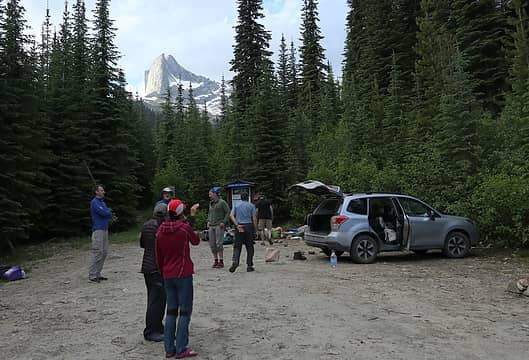 Gimli visible from our parking lot campsite. 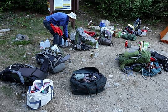 Sorting piles of gear 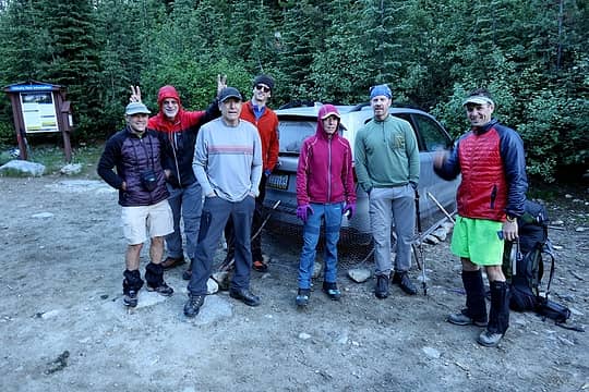 Ready to begin the trip (Don, Brett, Juan, Eric, Carla, Greg, Stefan 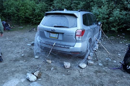 Americans can't go anywhere without building a wall (actually its porcupine protection) 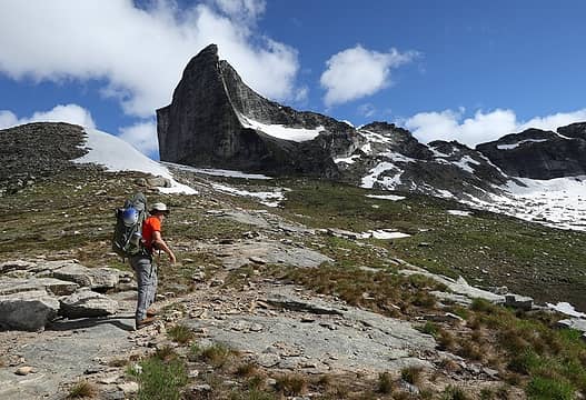 Brett hiking toward Gimli 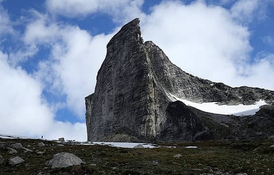 Hiker near the base of Gimli (that wall has a 5.9 route, scramble route curves around to ascend ridge at right) 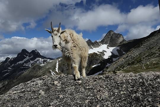 Goats immediately came running to greet us and eat our packs 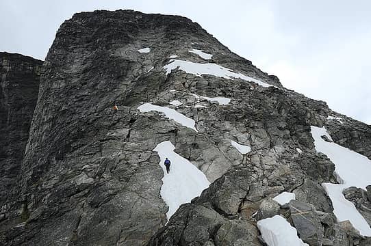 Scrambling up Gimli 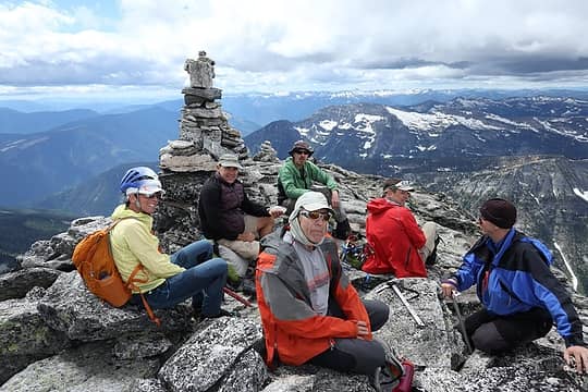 Gimli summit with me taking photo 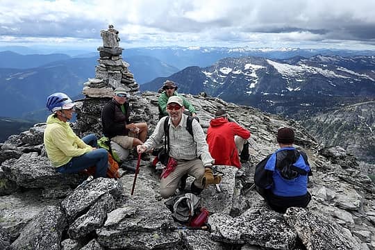 Gimli summit with Juan taking photo 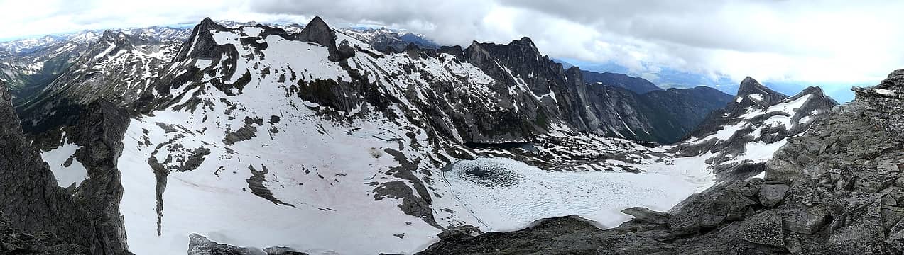 View of Mulvey Lakes basin, plus Asgard, from Gimli 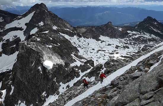 Descending Gimli 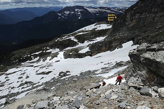 Returning to our packs  Hiker near the NIsleheim-Gimli Col 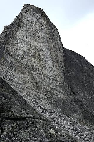 Goats following us around Gimli 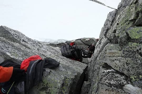 Lowering the packs at NIsleheim-Gimli Col  Walking the ledge at Gimli  Descending to Mulvey Lakes  Panorama eastward from Upper Mulvey Camp  Panorama south-west-north from Upper Mulvey Camp (Gimli, Nisleheim, Midard, Asgard) 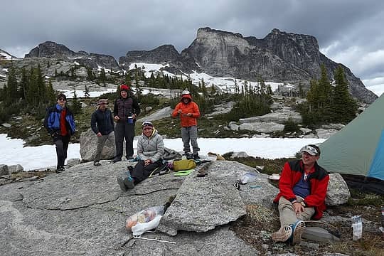 relaxing at camp 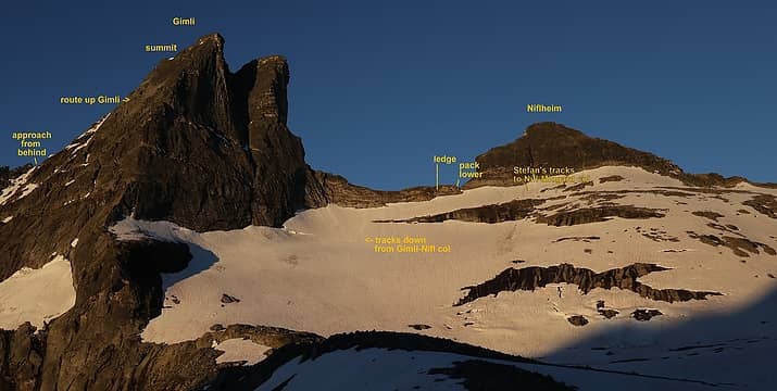 Our routes up and around Gimli, viewed from camp 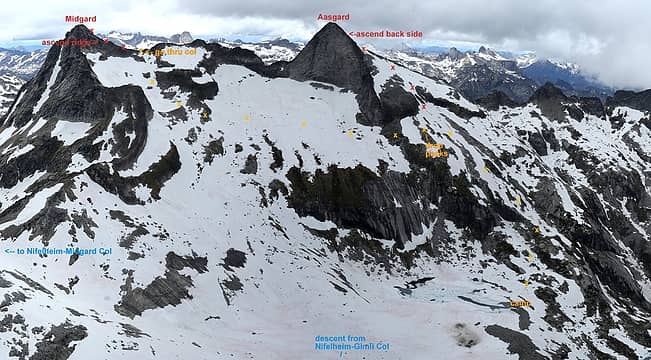 Routes up and between Asgard & Midgard
As beacons mountains burned at evening. J.R.R. Tolkien
As beacons mountains burned at evening. J.R.R. Tolkien
|
| Back to top |
|
|
olderthanIusedtobe
Member
Joined: 05 Sep 2011
Posts: 7722 | TRs | Pics
Location: Shoreline |
Looks fantastic! Don't see much in the way of TRs for that area. I did a couple day hikes in Valhalla PP quite a few years ago. Hit Gimli scramble route and Gwillim Lakes/Lucifer Peak. While the day hikes were great there's obviously some amazing terrain much further in that you hit during your traverse.
Nelson, BC is nicely situated, both Valhalla and Kokanee Glacier PP are nearby. I remember Slocan Lake being a nice place to cool off after I got done hiking in Valhalla.
Yeah, Gimli Peak is one of a kind, can't think of anything else that looks quite like that.
|
| Back to top |
|
|
Brushbuffalo
Member

Joined: 17 Sep 2015
Posts: 1887 | TRs | Pics
Location: there earlier, here now, somewhere later... Bellingham in between |
Just a fabulous looking trip! Thanks for the eye candy and details.
| Matt wrote: | | The Canadian border guard seemed obsessed with grizzlies. |
Yes, it is annoying/ odd what the Canadian border people tell you. As another example on a different topic, the fellow my wife had to deal with on her way to Manning Park to pick me up after my PCT hike insisted that I couldn't have the necessary paper work to re-enter the U.S., even though I did!  Back when Expo was held in Vancouver in 1986, the guvmint sent BC border personnel to a sort of " charm school" such as to not be offensive to entering foreigners.
Maybe it is needed again.
Back when Expo was held in Vancouver in 1986, the guvmint sent BC border personnel to a sort of " charm school" such as to not be offensive to entering foreigners.
Maybe it is needed again.
Passing rocks and trees like they were standing still
Passing rocks and trees like they were standing still
|
| Back to top |
|
|
Sore Feet
Member

Joined: 16 Dec 2001
Posts: 6303 | TRs | Pics
Location: Out There, Somewhere |
I was at Gwillim this last weekend. Super awesome place (and super bad mosquitoes). I was wondering about the traverse over to Valhalla Lake from Drinnon Pass too - looks doable based on Google Earth, so having this confirmation is a big plus. Two hours from the pass doesn't sound too bad at all given the terrain.
|
| Back to top |
|
|
Stefan
Member
Joined: 17 Dec 2001
Posts: 5093 | TRs | Pics
|
|
Stefan
Member
|
Wed Jul 25, 2018 9:07 am |
|
|
| Sore Feet wrote: | | I was at Gwillim this last weekend. Super awesome place (and super bad mosquitoes). I was wondering about the traverse over to Valhalla Lake from Drinnon Pass too - looks doable based on Google Earth, so having this confirmation is a big plus. Two hours from the pass doesn't sound too bad at all given the terrain. |
I would say that Rock Lakes and Hird lake north of Gwillim Lakes are better lakes as a destination than Valhalla Lake is. Rock/Hird Lakes are just as easy to get to as Valhalla Lake is. In fact Valhalla has those super annoying large boulders to go through while Rock/Hird Lakes do not.
|
| Back to top |
|
|
Matt
Tea, Earl Grey, Hot
Joined: 30 Jan 2007
Posts: 4308 | TRs | Pics
Location: Shoreline |
|
Matt
Tea, Earl Grey, Hot
|
Sat Jul 28, 2018 6:10 pm |
|
|
So much happened on this trip that it's taken a lot of study afterward even to match up the maps and photos to figure out where all we went along the way.
Sunday, July 8, Day 2: Asgard, Midgard, Prestley Lakes, Valhalla Lake
Itinerary
Start from Upper Mulvey Lake camp 7440 feet.
Ascend Asgard, drop packs at 8200 feet.
Side trip to Asgard 9268 via east ridge.
Traverse west to basin below Midgard and ascend to col NE of Midgard at 8900 feet.
Side trip to Midgard 9209 via NE ridge.
Descend to Upper Prestley Lake 7300.
Ascend NW to col at 8200 feet.
Descend to Upper Valhalla Lake 7500 then to outlet of Valhalla Lake 6900.
 Day 2 Map. The straight line west of Midgard is an error artifact from forgetting to turn the GPS back on after the back lowering delay. The purple line is a possible alternate route around Midgard. 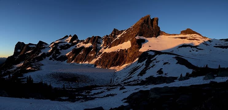 Sunrise from Mulvey Lakes Camp Routes up and between Asgard & Midgard (viewed previously from Gimli) 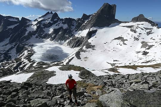 Hiking up from camp 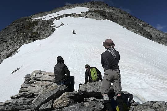 Ascending Asgard 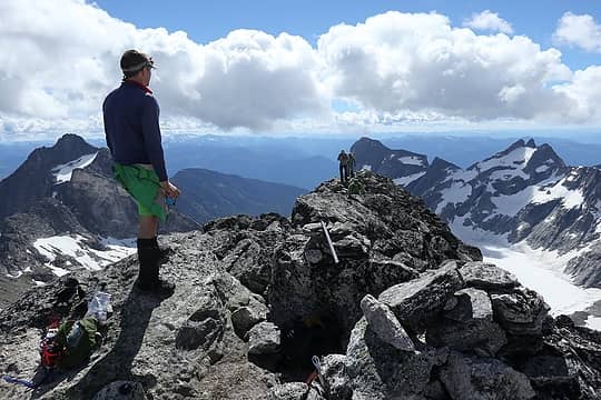 Stefan waiting at the top 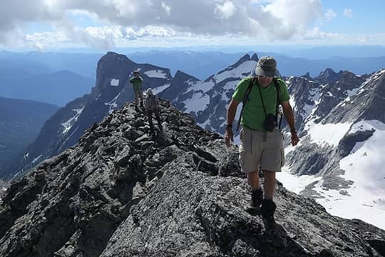 Don, Juan, and Greg arriving 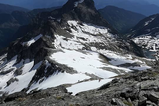 More people coming up 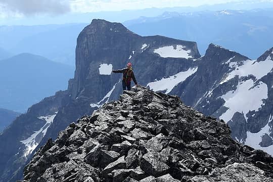 Carla arriving  Me directing something 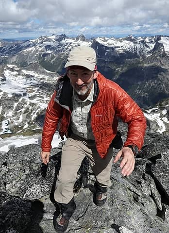 Me trying to get my camera back from Greg 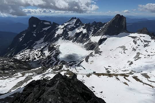 Looking SE back to Mulvey Lakes and Gimli 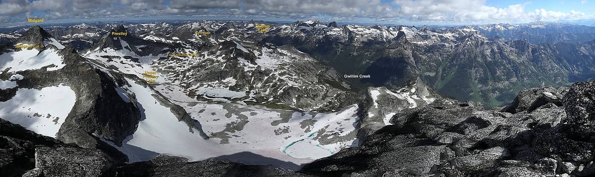 Looking NW toward Camp 2 at Valhalla Lake and Camp 3 at Gwillim Lakes 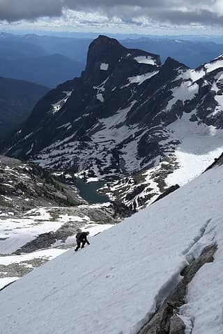 Descending off Asgard 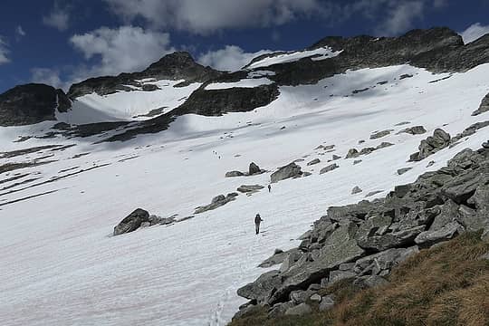 Traversing toward Midgard 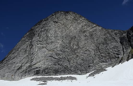 Below the big south face of Asgard 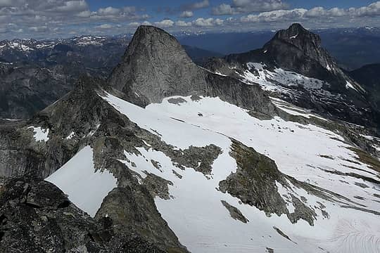 From Midgard, looking back down on the col, Asgard, and Gladsheim 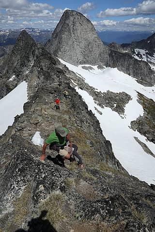 More people coming up Midgard 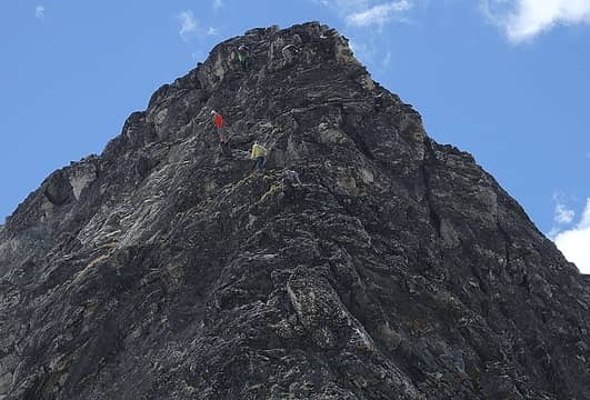 Scramblers higher up on Midgard 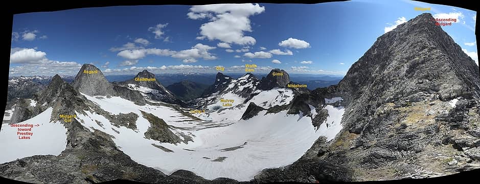 180-degree pan from midway up Midgard, with Erik descending beyond the col on right and scramblers ascending toward the summit on left 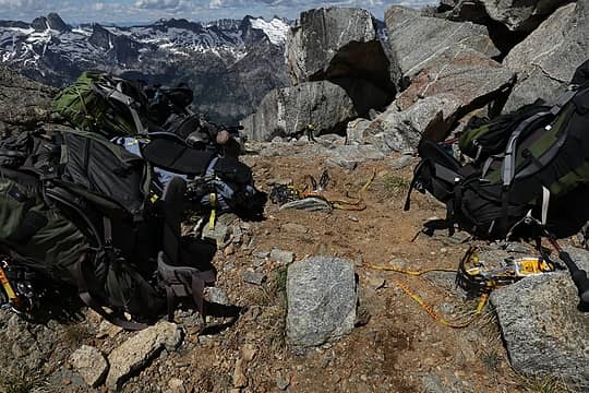 Piles of packs and crampons waiting at the Midgard Col 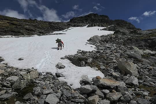 Backing down from the Midgard Col 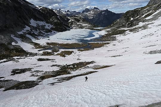 Hiking down snow to Prestley Lakes 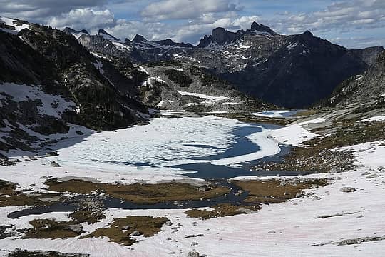 Beautiful lower Prestley Lake 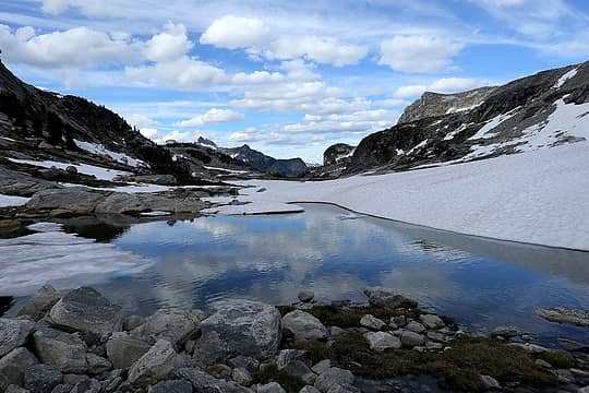 Hiking past the outlet of upper Prestley Lake 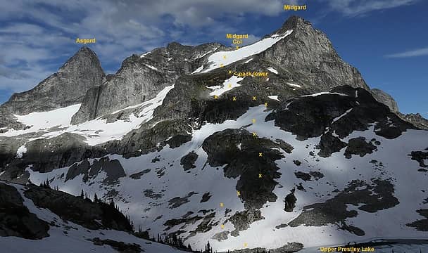 Looking back at the descent from Midgard Col to Upper Prestley  Hiking down toward Upper Valhalla Lake  Upper Valhalla Lake  Hiking past Upper Valhalla  Slab waterfalls descending to main Valhalla Lake 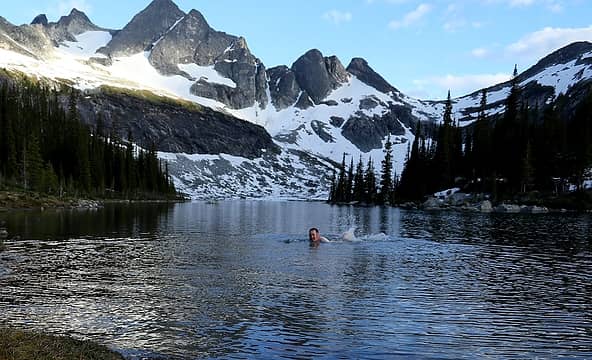 A refreshing cleansing swim in Valhalla Lake  Camp at Valhalla outlet
As beacons mountains burned at evening. J.R.R. Tolkien
As beacons mountains burned at evening. J.R.R. Tolkien
|
| Back to top |
|
|
Matt Lemke
High on the Outdoors

Joined: 15 Jul 2010
Posts: 2052 | TRs | Pics
Location: Grand Junction |
|
Matt Lemke
High on the Outdoors
|
Sat Jul 28, 2018 7:53 pm |
|
|
I really need to make a trip happen here. That south ridge of gimli looks STUNNING!
Awesome trip and photos 
|
| Back to top |
|
|
Matt
Tea, Earl Grey, Hot
Joined: 30 Jan 2007
Posts: 4308 | TRs | Pics
Location: Shoreline |
|
Matt
Tea, Earl Grey, Hot
|
Sat Jul 28, 2018 9:50 pm |
|
|
@Matt Lemke, apparently there's a bolted route up the south face of Asgard as well.
As beacons mountains burned at evening. J.R.R. Tolkien
As beacons mountains burned at evening. J.R.R. Tolkien
|
| Back to top |
|
|
|
|
You cannot post new topics in this forum
You cannot reply to topics in this forum
You cannot edit your posts in this forum
You cannot delete your posts in this forum
You cannot vote in polls in this forum
|
Disclosure: As an Amazon Associate NWHikers.net earns from qualifying purchases when you use our link(s). |


