| Previous :: Next Topic |
| Author |
Message |
iron
Member


Joined: 10 Aug 2008
Posts: 6392 | TRs | Pics
Location: southeast kootenays |
|
iron
Member
|
 Sun Dec 02, 2012 4:15 pm |
|
|
|
| Back to top |
  
|
|
onemoremile
Member

Joined: 26 Dec 2010
Posts: 1305 | TRs | Pics
Location: Sequim |
Early August should be. If you look for the gravel bars where the elk hang out, follow their trails- they usually cross at the easier places...(usually).
Arbolist? Look up the word. I dont know, maybe I made it up. Anyway, its an arbo-tree-ist, somebody who knows about trees. G.W. Bush
Arbolist? Look up the word. I dont know, maybe I made it up. Anyway, its an arbo-tree-ist, somebody who knows about trees. G.W. Bush
|
| Back to top |
|
|
Slugman
Its a Slugfest!

Joined: 27 Mar 2003
Posts: 16874 | TRs | Pics
|
|
Slugman
Its a Slugfest!
|
Sun Dec 02, 2012 4:47 pm |
|
|
Short cut to Olympus? 
|
| Back to top |
|
|
tinman
Member

Joined: 08 Oct 2004
Posts: 355 | TRs | Pics
Location: Where it rains, WA |
|
tinman
Member
|
Sun Dec 02, 2012 4:57 pm |
|
|
Yep, I agree with OMM. You might also find blowdown trees to cross on, but early August should be fairly easy to find a spot to cross.
Wherever you go, there you are.......
Wherever you go, there you are.......
|
| Back to top |
|
|
RodF
Member

Joined: 01 Sep 2007
Posts: 2593 | TRs | Pics
Location: Sequim WA |
|
RodF
Member
|
Sun Dec 02, 2012 5:45 pm |
|
|
The 1923 Olympic National Forest map shows the original trail route to Mount Olympus crossed the Hoh in that area, and climbed the ridge between Falls and Glacier Creeks. (Note there is ambiguity in the maps as to which creek is Falls Creek!) The 1923 trail description reads:
| Quote: | | Hoh Trail branches from the old Pacific Trail, or projected Olympic Highway, l2 miles south of Forks, and follows the north bank of the main Hoh River on an easy grade to the Olympus Ranger Station, 2 miles above the junction with the Canyon-Hoh Trail, a distance of about 28 miles. Foot travel is possible above the station, and Mount Olympus has been climbed three or four times from this side, but the route is not well defined and is somewhat hazardous. |
Whether the old route is remains as described above may depend on whether it was abandoned due to landslide or avalanche, or simply for the easier new trail route for pack stock built past Elk Lake that appeared on the 1930 map? I've asked several people in the Park, and found no one who knows anything about this old route. Sure is an interesting thing to explore, Iron!
Note added: the Klahhane Club account of their 1922 outing reads:
| Quote: | | Mt. Olympus was visited again in 1922 by a party of eight. They left from the Sol Due Hot Springs going over Bogachiel at an elevation of 4,500 feet, dropping down to 1,200 feet in the Hoh, then following a trapper's line to the Stewart cabin at 4,200 feet. From there they went down again to the 2,600 level of Glacier Creek which made them climb about four mountains. |
"of all the paths you take in life, make sure a few of them are dirt" - John Muir
"the wild is not the opposite of cultivated. It is the opposite of the captivated - Vandana Shiva
"of all the paths you take in life, make sure a few of them are dirt" - John Muir
"the wild is not the opposite of cultivated. It is the opposite of the captivated - Vandana Shiva
|
| Back to top |
|
|
iron
Member
Joined: 10 Aug 2008
Posts: 6392 | TRs | Pics
Location: southeast kootenays |
|
iron
Member
|
Sun Dec 02, 2012 6:04 pm |
|
|
great page rod!
some lines really stand out to me:
| Quote: | | The suggested excess cut is allowable for the purpose of utilizing the surplus old growth throughout a reasonable period, in order that the forest may eventually be placed on a sustained-yield basis of cutting each year just what the forest acreage will normally produce. Present knowledge warrants a cut of about 400 million board feet per year during the first cutting cycle, and this would mean a handsome public revenue. |
| Quote: | | Put tin cans and rubbish in the garbage cans or the holes dug for disposing of such materials. |
| Quote: | | On the steeper north shore of Lake Crescent are two groups of summer-home lots, some of which are not yet in use. On Quinault Lake are a large number of these sites, and many of them are still inappropriate. For summer homes in the vicinity of these two lakes the Forest Service charges a rental of $10 to $15 per year. |
| Quote: | | Olympic elk have increased in late years to probably 7,000 within the boundaries of the Olympic National Forest, and perhaps 1,000 in the low rolling coast lands just west of the Forest boundary. The elk in large bands of more than a hundred are oft seen in the high mountain meadows by summer travelers, but are driven down into the lower west side country by the winter snows. Natural browse feed is becoming scarce in the few winter-feeding valleys on the heavily timbered west slope. This largely due to the natural barriers of dense timber and high, intervening ridges, as well as the natural instinct of the Olympic elk to return year after year to the range on which they were born. |
do we still see elk populations like this in 2012?
|
| Back to top |
|
|
Malachai Constant
Member

Joined: 13 Jan 2002
Posts: 16097 | TRs | Pics
Location: Back Again Like A Bad Penny |
In 1937 they declared open season on elk in the Olympics because they thought them overpopulated. It is reported in Murry Morgans book Last Wilderness. Over 800 elk where shot and general havoc ensued, it was never repeated. 
"You do not laugh when you look at the mountains, or when you look at the sea." Lafcadio Hearn
"You do not laugh when you look at the mountains, or when you look at the sea." Lafcadio Hearn
|
| Back to top |
|
|
onemoremile
Member
Joined: 26 Dec 2010
Posts: 1305 | TRs | Pics
Location: Sequim |
Still plenty of elk in the park. I think August will be a little early for the big herds, by about a month. I think last I read was that there 8,000 in the park.
Arbolist? Look up the word. I dont know, maybe I made it up. Anyway, its an arbo-tree-ist, somebody who knows about trees. G.W. Bush
Arbolist? Look up the word. I dont know, maybe I made it up. Anyway, its an arbo-tree-ist, somebody who knows about trees. G.W. Bush
|
| Back to top |
|
|
RodF
Member
Joined: 01 Sep 2007
Posts: 2593 | TRs | Pics
Location: Sequim WA |
|
RodF
Member
|
Sun Dec 02, 2012 9:52 pm |
|
|
The number onemoremile cites for the Park is what I also recall hearing last year in a talk by Kurt Jenkins and Patti Happe. More than a thousand of those migrate outside the Park in winter. WDFW in 2005 estimated elk outside the Park at 8610 (fall count)(and rising towards the management goal of 11,350). That'd put the total on the Olympic Peninsula at roughly 16,000 and rising. Numbers were lower in the 1930s and higher in the 1980s because of the amount of habitat opened by logging.
"of all the paths you take in life, make sure a few of them are dirt" - John Muir
"the wild is not the opposite of cultivated. It is the opposite of the captivated - Vandana Shiva
"of all the paths you take in life, make sure a few of them are dirt" - John Muir
"the wild is not the opposite of cultivated. It is the opposite of the captivated - Vandana Shiva
|
| Back to top |
|
|
kite
Member

Joined: 28 Sep 2009
Posts: 1416 | TRs | Pics
Location: Olympia |
|
kite
Member
|
Sun Dec 02, 2012 11:23 pm |
|
|
I have crossed at Happy 4 in September with no problems and last April at the Olymus Guard Station it wound have been easy, might have been able to keep your feet dry if you looked a good log. The river is real braided with lots of logs.
photos from April trip
|
| Back to top |
|
|
silence
Member

Joined: 25 Apr 2005
Posts: 4420 | TRs | Pics
|
|
silence
Member
|
Mon Dec 03, 2012 9:06 am |
|
|
Thanks for posting that map Rod .. I have eyed that route for a few years now but for Mt Tom, not Olympus .. but thought it might be ezier to just head down from Elk Lake instead of crossing the river .. it looks tough regardless ... not something for our old legs now
 Mt Tom and the White Glacier
PHOTOS
FILMS
Keep a good head and always carry a light bulb. Bob Dylan
PHOTOS
FILMS
Keep a good head and always carry a light bulb. Bob Dylan
|
| Back to top |
|
|
RodF
Member
Joined: 01 Sep 2007
Posts: 2593 | TRs | Pics
Location: Sequim WA |
|
RodF
Member
|
Mon Dec 03, 2012 3:44 pm |
|
|
| silence wrote: | | After some research I found there is an old route up Falls Creeks to Mt Tom instead |
Wood's trail guide (and OMR's Climbers Guide, route 2) mentions Mount Tom Creek Trail, which first appeared on the 1932 map.
(The modern upper Hoh Trail, up Glacier Creek past Elk Lake, first appeared on the 1930 map. The original Olympus Ranger Station / shelter and the Elk Lake Shelter was built in 1927, presumably to support trail construction. The "new" (squared log) Olympus RS was built in 1931.)
The USFS was very busy building trails in the 1920s, well before the CCC era. And had ambitions for many more... see Fred Cleator's 1929 Olympic Recreation Plan.
"of all the paths you take in life, make sure a few of them are dirt" - John Muir
"the wild is not the opposite of cultivated. It is the opposite of the captivated - Vandana Shiva
"of all the paths you take in life, make sure a few of them are dirt" - John Muir
"the wild is not the opposite of cultivated. It is the opposite of the captivated - Vandana Shiva
|
| Back to top |
|
|
Dane
Other

Joined: 14 Mar 2006
Posts: 2466 | TRs | Pics
Location: Seattle |
|
Dane
Other
|
Mon Dec 03, 2012 4:54 pm |
|
|
Haven't spent much time on the Hoh, but my guess would be yes. Phil forded and journeyed up Mt. Tom Creek in early Oct. 2010.
I hear Lake 5185 is a really special place. I'd love to hear more about your plans...still haven't been up Olympus, got turned back by avalanches this past May.
Without judgement what would we do? We would be forced to look at ourselves...
-Death
Without judgement what would we do? We would be forced to look at ourselves...
-Death
|
| Back to top |
|
|
Ancient Ambler
Member

Joined: 15 May 2007
Posts: 1092 | TRs | Pics
Location: Bainbridge Island |
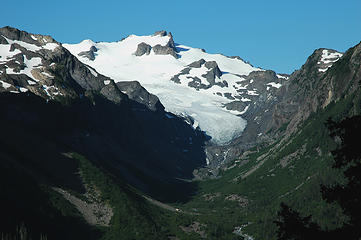
Crossing the Hoh in that area suggests your itinerary may include the Ridge of the Gods, the Lakes of the Gods and/or Mount Tom. If so, you might be interested in these photos. If not, sorry for the thread drift.
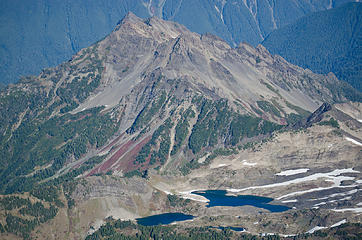 4 labels Lakes of the Gods & Ridge of the Gods, from SW 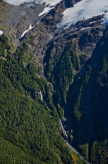 3 labels Falls on N Fork Mt Tom Creek & NW lobe of White Glacier, from W
|
| Back to top |
|
|
silence
Member
Joined: 25 Apr 2005
Posts: 4420 | TRs | Pics
|
|
silence
Member
|
Tue Dec 04, 2012 8:35 am |
|
|
| Ancient Ambler wrote: | Crossing the Hoh in that area suggests your itinerary may include the Ridge of the Gods, the Lakes of the Gods and/or Mount Tom. If so, you might be interested in these photos. If not, sorry for the thread drift.
4 labels Lakes of the Gods & Ridge of the Gods, from SW 3 labels Falls on N Fork Mt Tom Creek & NW lobe of White Glacier, from W |
Drooling at the prospect ... but a lost opportunity for us now ;-(
PHOTOS
FILMS
Keep a good head and always carry a light bulb. Bob Dylan
PHOTOS
FILMS
Keep a good head and always carry a light bulb. Bob Dylan
|
| Back to top |
|
|
|
|


