| Previous :: Next Topic |
| Author |
Message |
puzzlr
Mid Fork Rocks


Joined: 13 Feb 2007
Posts: 7220 | TRs | Pics
Location: Stuck in the middle |
|
puzzlr
Mid Fork Rocks
|
 Fri Sep 20, 2013 11:29 pm |
|
|
I noticed this because of my recent hike up the Pratt Valley. I don't think it's been this way very long in this area because I probably would have noticed. In fact if you click on the "historical imagery" button in GE, even the most recent imagery in that mode doesn't show this problem.
I will be submitting this to the GE feedback forum, but don't have a lot of hope that anything will change. I've submitted a number of mistakes over the years and most of them have never been fixed.
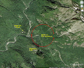 Shifted terrain 1  Shifted terrain 2 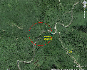 Shifted terrain 3
|
| Back to top |
  
|
|
Joey
verrry senior member

Joined: 05 Jun 2005
Posts: 2798 | TRs | Pics
Location: Redmond |
|
Joey
verrry senior member
|
Sat Sep 21, 2013 10:59 am |
|
|
I noticed the "Shifted terrain 2" issue a couple days ago. Hopefully they have not messed up too many other spots.
|
| Back to top |
|
|
twodogdad
Member

Joined: 21 Nov 2006
Posts: 846 | TRs | Pics
Location: seattle |
Imagine the headache such shifts are to smart-bomb operators. N
|
| Back to top |
|
|
mtnresqr
Member
Joined: 18 May 2010
Posts: 48 | TRs | Pics
|
|
mtnresqr
Member
|
Wed Sep 25, 2013 12:40 pm |
|
|
Doing a rough check and using UTM, so that distance come out in simply "meters East & North", i checked at the Picture 3 area, and came up with a shift of 128 meters Easting and 209 meters Northing. That is very close to the "error shift" associated with a Datum shift from NAD27 and NAD83. We have plotted that in SAR, and come up with about 90-100 meters Easting by 220 meters Northing. For SAR we checked the entire State of Washington, and averaged to get those figures.
So, maybe GoogleEarth is getting older maps at NAD27 and now coming in with NAD83 (WGS84) maps, or vice-versa.
|
| Back to top |
|
|
puzzlr
Mid Fork Rocks
Joined: 13 Feb 2007
Posts: 7220 | TRs | Pics
Location: Stuck in the middle |
|
puzzlr
Mid Fork Rocks
|
Mon Sep 01, 2014 1:00 pm |
|
|
Finally, a year later, new imagery including the Central Cascades has corrected the shifted area in the Pratt Valley. I've run across similar shifts elsewhere but don't look into them as deeply. Now the default view is correct but if you click on the historical imagery the most recent previous view shows the shift. I'm glad this is finally corrected. I submitted a bug last year but I doubt that had much to do with getting it fixed.
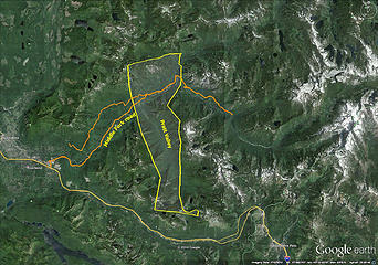 The area inside the yellow boundary was shifted on Google Earth imagery for almost a year. 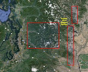 This update corrected several annoying imagery shifts in the central Cascades
|
| Back to top |
|
|
DRSpalding
Probably riding MTB
Joined: 13 Mar 2008
Posts: 458 | TRs | Pics
Location: Redmond, WA |
|
DRSpalding
Probably riding MTB
|
Mon Sep 01, 2014 7:40 pm |
|
|
It's still wrong via GMap and Strava while using the satellite imagery, but Google Earth has it correct. I noticed it because my MTB track up the CCC road, riding out the existing (closed) road, and then onto the CCC trail has me crossing the river in the satellite view! The portion of the image looks to be shifted north by a couple hundred meters.
View larger size in new window
If you shift to Topo High USA, you can see that my GPS track is faithfully on the road and trails.
Does it normally take "a while" for the images to populate out from Google Earth usage to available to the normal API levels?
|
| Back to top |
|
|
Joey
verrry senior member
Joined: 05 Jun 2005
Posts: 2798 | TRs | Pics
Location: Redmond |
|
Joey
verrry senior member
|
Mon Sep 01, 2014 8:20 pm |
|
|
It is simply some misaligned aerial imagery. If you look at the center of this map you can see that the aerial to the right of the center has been incorrectly shifted north. As a result your track shows that you have mastered the trick of walking on water.
View larger size in new window
|
| Back to top |
|
|
DRSpalding
Probably riding MTB
Joined: 13 Mar 2008
Posts: 458 | TRs | Pics
Location: Redmond, WA |
|
DRSpalding
Probably riding MTB
|
Mon Sep 01, 2014 10:07 pm |
|
|
Yes, I understand that. It is, however, correct in Google Earth (the app). I was wondering why the user-API-accessible maps were different and if we could expect the new content to come up aligned properly as it is in Google Earth.
|
| Back to top |
|
|
puzzlr
Mid Fork Rocks
Joined: 13 Feb 2007
Posts: 7220 | TRs | Pics
Location: Stuck in the middle |
|
puzzlr
Mid Fork Rocks
|
Tue Sep 02, 2014 12:28 am |
|
|
I'm sure it will eventually propagate into the Google maps satellite view. Most of the time the imagery is the same. I rarely use that view because I find Google Earth much better for virtual exploring, so I probably won't notice when it catches up. Let us know if you do.
|
| Back to top |
|
|
DRSpalding
Probably riding MTB
Joined: 13 Mar 2008
Posts: 458 | TRs | Pics
Location: Redmond, WA |
|
DRSpalding
Probably riding MTB
|
Tue Sep 02, 2014 3:24 pm |
|
|
The imagery dated 7/15/2014 in GE is clearly newer/different than what is being pulled by Gmap4 and Strava. If you look at the sat views of each where the new bridge is going in just to the east of the CCC Trail trailhead and road closure on the Middle Fork Road, you can see the excavation happening and the old bridge is already gone. The view in Gmap4 and Strava show the old bridge and perhaps only a minor amount of prep for the construction from the 7/13/2013 imagery.
So, perhaps it will get corrected soon.
|
| Back to top |
|
|
DIYSteve
seeking hygge

Joined: 06 Mar 2007
Posts: 12654 | TRs | Pics
Location: here now |
|
DIYSteve
seeking hygge
|
Tue Sep 02, 2014 3:38 pm |
|
|
I've seen at least two other places with screwy aerial views on the Gmap sat image database during my route planning this summer
|
| Back to top |
|
|
puzzlr
Mid Fork Rocks
Joined: 13 Feb 2007
Posts: 7220 | TRs | Pics
Location: Stuck in the middle |
|
puzzlr
Mid Fork Rocks
|
Tue Sep 02, 2014 6:10 pm |
|
|
| DRSpalding wrote: | | you can see the excavation happening and the old bridge is already gone. |
Great spotting. That was in July when the creek was diverted, the abutments were in place and the temporary road dipped down into the old creek bed.
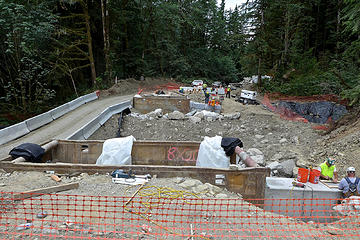 MP 10.6 bridge, July 19, 2014 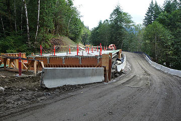 MP 10.6 bridge, August 16, 2014
|
| Back to top |
|
|
DRSpalding
Probably riding MTB
Joined: 13 Mar 2008
Posts: 458 | TRs | Pics
Location: Redmond, WA |
|
DRSpalding
Probably riding MTB
|
Tue Sep 23, 2014 10:14 am |
|
|
The new maps, properly aligned, are now showing up in the API driven uses of the sat photos.
|
| Back to top |
|
|
wolffie
Member

Joined: 14 Jul 2008
Posts: 2693 | TRs | Pics
Location: Seattle |
|
wolffie
Member
|
Tue Sep 23, 2014 1:52 pm |
|
|
Maybe it was them who caused to Oso landslide.
I don't think they should have a right to go altering our landscape like this. If they go dumping forests onto rivers like that, won't it dam up the river, causing possible dam failure and catastrophic flooding?
I'm afraid of them. I've seen Google Maps make lakes that cross contour lines. Anybody who can do that has too much power.
Some people have better things to do with their lives than walking the dog. Some don't.
Some people have better things to do with their lives than walking the dog. Some don't.
|
| Back to top |
|
|
puzzlr
Mid Fork Rocks
Joined: 13 Feb 2007
Posts: 7220 | TRs | Pics
Location: Stuck in the middle |
|
puzzlr
Mid Fork Rocks
|
Wed Oct 01, 2014 10:04 am |
|
|
This is unfortunate. For the year that the imagery was shifted the route of the Middle Fork road was correct. But now in October, 2014 a section of the road has been routed to match the old incorrect shifted imagery. The road route is correct on Google Maps, so I don't know how to go about fixing this. I guess I'll file another bug and wait another year for it to get fixed.
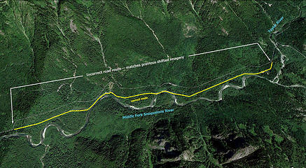 Middle Fork Road Error  for it to show up in GE. for it to show up in GE.
|
| Back to top |
|
|
|
|


