| Previous :: Next Topic |
| Author |
Message |
Dayhike Mike
Bad MFKer


Joined: 02 Mar 2003
Posts: 10958 | TRs | Pics
Location: Going to Tukwila |
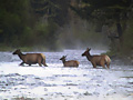
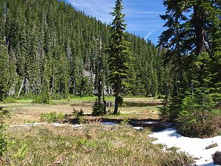
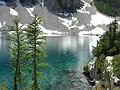
Tom and I just got back from four days (7/5 to 7/8) bagging some lakes in the North Cascades. We had great weather and I had a really good time.
Day One:
The trip into the Jordans wasn't too bad. Pretty area. We opted to walk around Lower Jordan when we probably should have rafted it. Upper Jordan was neat...liked that little tarn on the right side that's built right into the lake.
I was exhausted after the first day. Not sure if it was the heat or just the fact that this was my first real trip of the season, but I was ready to settle down in camp when we found a good place at Upper Jordan that wasn't under snow.
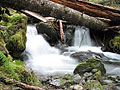
 Great suggestion for the MFK gate  Tarn en route to the Jordans  Lower Jordan  Arriving at Upper Jordan  Mmm. Tasty.  Upper Jordan  Tarn on Upper Jordan  Leaving Upper Jordan  Leaving Jordan Vertical  Leaving Jordan Pano  Tarn above Upper Jordan  First views of Upper Granite  Phenomenal colors  Upper Granite Pano #1  Upper Granite Pano #2  First views of Lower Granite  Lower Granite Outlet  Looking Back on Upper Granite  Arriving at Lower Granite  Shoreline along Lower Granite  Cliffs above Lower Granite  Point 6780 from Tarn above Lower Granite  Tarn above Lower Granite  Snowking and Kindy Ridge  Point 6870 from Ridge Camp
"There is only one basic human right, the right to do as you damn well please. And with it comes the only basic human duty, the duty to take the consequences." -P.J. O'Rourke
"Ignorance is natural. Stupidity takes commitment." -Solomon Short
"There is only one basic human right, the right to do as you damn well please. And with it comes the only basic human duty, the duty to take the consequences." -P.J. O'Rourke
"Ignorance is natural. Stupidity takes commitment." -Solomon Short
|
| Back to top |
  
|
|
ScottM
Member

Joined: 18 Apr 2007
Posts: 363 | TRs | Pics
Location: The Olympics |
|
ScottM
Member
|
 Tue Jul 10, 2007 9:03 pm |
|
|
I'm not sure but at first I thought it looked kind of similar to this one.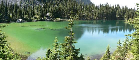 silver lakes pano4
|
| Back to top |
|
|
Schmidt Altitude
Whippet Entourage

Joined: 28 Mar 2007
Posts: 803 | TRs | Pics
Location: The Quah |
Scary slide incident....VERY glad you are ok! 
"Forest 101: These big wood stick things are called trees. The big rocks are called mountains, and the little rocks are their babies." Elliott from Open Season
"Forest 101: These big wood stick things are called trees. The big rocks are called mountains, and the little rocks are their babies." Elliott from Open Season
|
| Back to top |
|
|
Tom
Admin
Joined: 15 Dec 2001
Posts: 17857 | TRs | Pics
|
|
Tom
Admin
|
Wed Jul 11, 2007 4:22 am |
|
|
So was I! Other than that, a really enjoyable trip. Too bad we got clouded out the last day but I guess it helped me pare it down to 12 pics per day. 
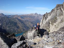
 Tarn 4260 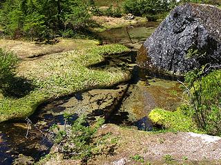 Stream Crossing 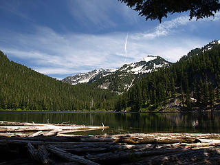 Arriving at Lower Jordan 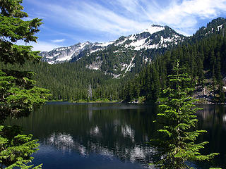 Going around Lower Jordan 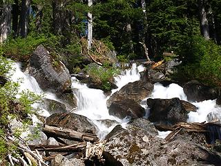 Outlet Falls From Upper Jordan 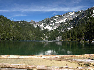 Pollen at Upper Jordan Logjam 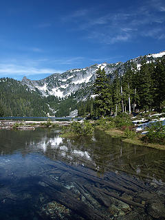 Upper Jordan From Outlet Stream 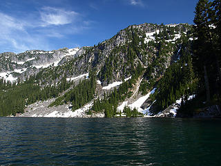 Rafting Upper Jordan 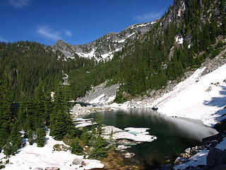 Upper Jordan Side Tarn 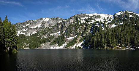 Upper Jordan From Camp 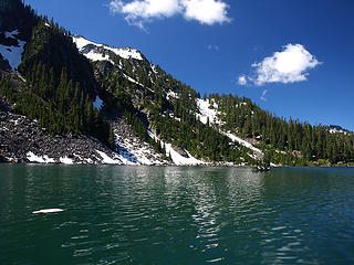 Mike Rafting Upper Jordan 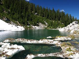 Avalanche Remnants at Upper Jordan Side Tarn 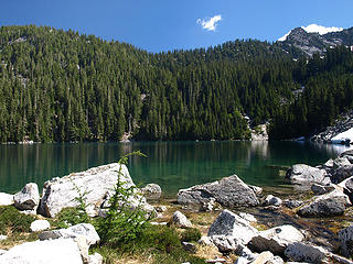 Upper Jordan from Side Tarn 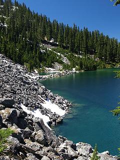 Upper Jordan and Side Tarn 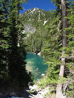 Looking Back to Upper Jordan Inlet 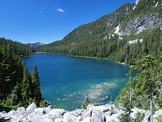 Leaving Upper Jordan 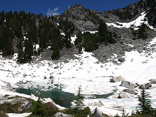 Arriving at Tarn Above Upper Jordan 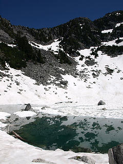 Tarn Above Upper Jordan 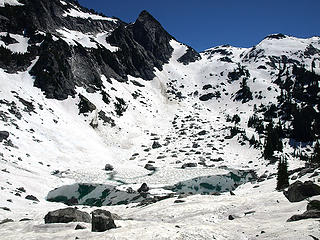 Leaving Tarn Above Upper Jordan 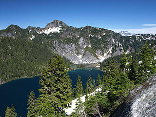 First Views of Big Granite 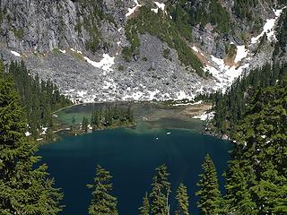 Zooming in to Big Granite Inlet 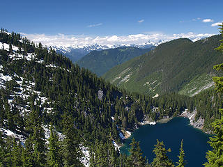 Big Granite Outlet 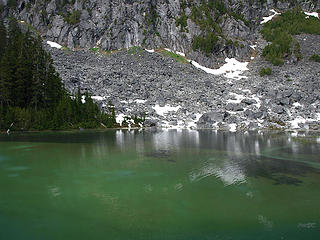 Big Granite Inlet Pool 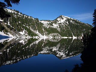 Morning Reflections at Big Granite 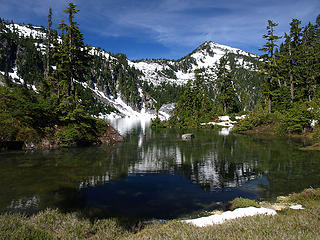 Big Granite Cove 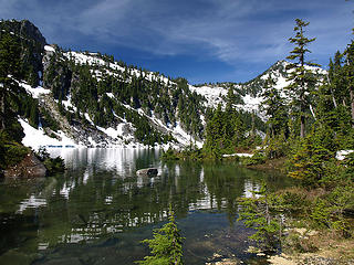 Leaving Big Granite 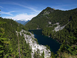 4679 Granite from Ridge 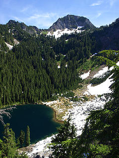 4679 Granite Inlet 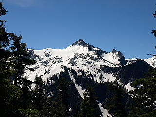 Point 6780 from Ridge Between Granites 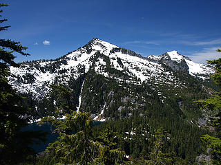 Big Granite and Point 6377 From Ridge Between Granites 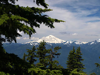 Baker From Ridge Between Granites 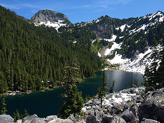 Descending to 4679 Granite 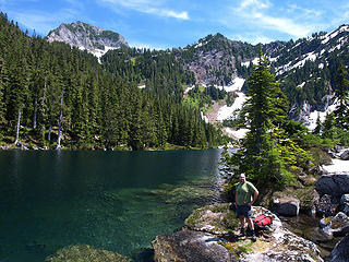 Mike at 4679 Granite 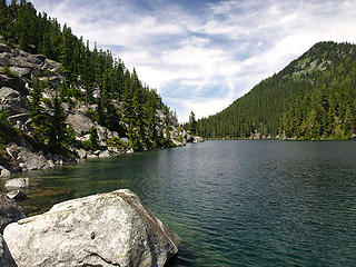 Arriving at 4679 Granite 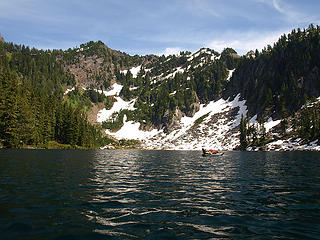 Rafting 4679 Granite 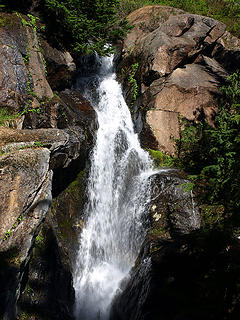 Outlet Waterfall from 5564 Granite 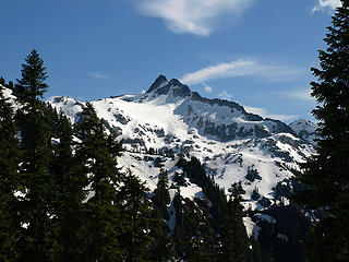 Point 6780 from Ascent to 5564 Granite 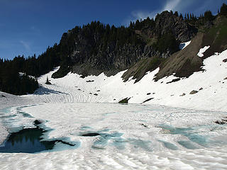 Arriving at 5564 Granite 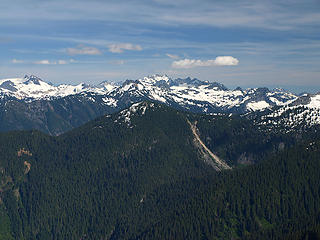 North Cascades From Traverse to High Camp 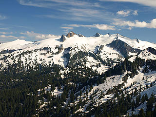 Snowking from Traverse to High Camp 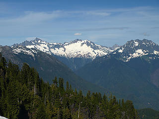 Eldorado, Boston, and Johannesburg from Traverse to High Camp 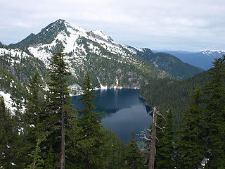 Big Granite From High Camp 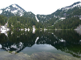 Arriving at Whale Lake 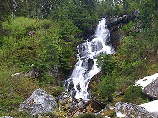 Whale Lake Inlet Falls 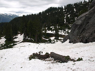 Leaving Tarn Above Whale Lake 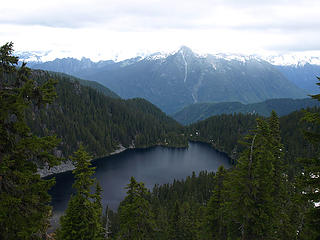 Looking Back To Whale Lake 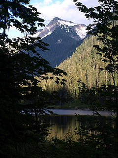 Leaving Slide Lake 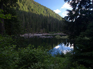 Slide Lake Ponds
|
| Back to top |
|
|
Kat
Turtle Hiker
Joined: 05 Oct 2003
Posts: 2560 | TRs | Pics
|
|
Kat
Turtle Hiker
|
Wed Jul 11, 2007 6:42 am |
|
|
Beautiful photos and great TR - this is the stuff that inspires me to get out and go- and boy, what a scare that slide must have been. Glad you're OK.
P.S. DHM - love that first pic 
|
| Back to top |
|
|
Backpacker Joe
Blind Hiker

Joined: 16 Dec 2001
Posts: 23956 | TRs | Pics
Location: Cle Elum |
Thank God Mr. Michael is ok. I think this deserves a pizza and beer tonight on me!
What a great trip and pics guys. Wish I could have gone along. So did you stay at big Granites inlet? THere is a cool camp site at big Granite's outlet. Did you make it to Upper (Little Granite) Granite's outlet? That outlet area is really neat. Thanks for the pics.
"If destruction be our lot we must ourselves be its author and finisher. As a nation of freemen we must live through all time or die by suicide."
Abraham Lincoln
"If destruction be our lot we must ourselves be its author and finisher. As a nation of freemen we must live through all time or die by suicide."
Abraham Lincoln
|
| Back to top |
|
|
ree
Member

Joined: 29 Jun 2004
Posts: 4399 | TRs | Pics
|
|
ree
Member
|
Wed Jul 11, 2007 6:51 am |
|
|
Beautiful pictures, guys, and great tr Mike. Glad you made it back safe. 
|
| Back to top |
|
|
Magellan
Brutally Handsome

Joined: 26 Jul 2006
Posts: 13117 | TRs | Pics
Location: Inexorable descent |
|
Magellan
Brutally Handsome
|
Wed Jul 11, 2007 6:51 am |
|
|
Glad you are ok Mike! What a great trip for you guys. Why did you resist rafting those two times? Was it just the effort to inflate, etc?
|
| Back to top |
|
|
Tom
Admin
Joined: 15 Dec 2001
Posts: 17857 | TRs | Pics
|
|
Tom
Admin
|
Wed Jul 11, 2007 12:02 pm |
|
|
Why resist rafting? Here's the process: unpack raft and thermarest, inflate raft and thermarest, put camera in waterproof bag, take off boots, pack boots and poles, find good launch spot, try not to get wet getting in, pull pack onto raft without dunking into lake, raft lake, find good spot to dump pack and exit raft, exit, dry off, wait for raft and thermarest to dry, deflate raft and thermarest, re-pack, put on boots...
BPJ, nope we didn't have time to check out the Granite outlets or the lower pots. Maybe if we ever go in the normal way. Is there a trail from Big Granite's outlet to the inlet? I was surprised to see so much impact at the inlet where we camped as it doesn't look that easy to get over there without a raft. Also, is there really a WC at Granite No. 2? I've never seen WC labeled on a USGS Quad. Something makes me think the map maker was having a little fun with that one. 
|
| Back to top |
|
|
Backpacker Joe
Blind Hiker
Joined: 16 Dec 2001
Posts: 23956 | TRs | Pics
Location: Cle Elum |
There is no trail from big Granites outlet to inlet. Rafting is it. Remember, they flew float planes in there prior to the late 70's. Im sure thats where most of the inpact came from. What is a WC? Ive been around both the Pots.
"If destruction be our lot we must ourselves be its author and finisher. As a nation of freemen we must live through all time or die by suicide."
Abraham Lincoln
"If destruction be our lot we must ourselves be its author and finisher. As a nation of freemen we must live through all time or die by suicide."
Abraham Lincoln
|
| Back to top |
|
|
Tom
Admin
Joined: 15 Dec 2001
Posts: 17857 | TRs | Pics
|
|
Tom
Admin
|
Wed Jul 11, 2007 1:52 pm |
|
|
|
| Back to top |
|
|
Backpacker Joe
Blind Hiker
Joined: 16 Dec 2001
Posts: 23956 | TRs | Pics
Location: Cle Elum |
"If destruction be our lot we must ourselves be its author and finisher. As a nation of freemen we must live through all time or die by suicide."
Abraham Lincoln
|
| Back to top |
|
|
Tom
Admin
Joined: 15 Dec 2001
Posts: 17857 | TRs | Pics
|
|
Tom
Admin
|
Wed Jul 11, 2007 2:09 pm |
|
|
|
| Back to top |
|
|
Backpacker Joe
Blind Hiker
Joined: 16 Dec 2001
Posts: 23956 | TRs | Pics
Location: Cle Elum |
Well then.... I sure didnt see anything like that. Ive hiked from the road around the lake up the draw to Big Granite and I never did see anything like that... Seems krazie to me to put something like that at that crummy little lake and not one of the big lakes.
"If destruction be our lot we must ourselves be its author and finisher. As a nation of freemen we must live through all time or die by suicide."
Abraham Lincoln
"If destruction be our lot we must ourselves be its author and finisher. As a nation of freemen we must live through all time or die by suicide."
Abraham Lincoln
|
| Back to top |
|
|
kleet
meat tornado

Joined: 06 Feb 2002
Posts: 5303 | TRs | Pics
Location: O no they dih ent |
|
kleet
meat tornado
|
Wed Jul 11, 2007 2:27 pm |
|
|
| Tom wrote: | | I've never seen WC labeled on a USGS Quad. Something makes me think the map maker was having a little fun with that one. |
Let's leave the joking to the pros.
WC= Witness Corner: A monumented survey point being used as a reference, usually located near a section corner. A witness corner is used when the corner is so situated as to render its monumentation impractical (as in a lake).
Great TR and photos, by the way! I'm surprised there wasn't more snow.
A fuxk, why do I not give one?
A fuxk, why do I not give one?
|
| Back to top |
|
|
|
|
You cannot post new topics in this forum
You cannot reply to topics in this forum
You cannot edit your posts in this forum
You cannot delete your posts in this forum
You cannot vote in polls in this forum
|
Disclosure: As an Amazon Associate NWHikers.net earns from qualifying purchases when you use our link(s). |


