| Previous :: Next Topic |
| Author |
Message |
Dayhike Mike
Bad MFKer

Joined: 02 Mar 2003
Posts: 10958 | TRs | Pics
Location: Going to Tukwila |
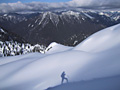
Tom and I had a good time stretching our legs for 3 days this week and thankfully managed to get some great weather for the trip.
Wednesday, we got an early start and headed out to the Canyon Creek trailhead. The trail rises at an excellent grade from the valley floor to McMillan Park. We got to the turnoff for Crater Lake before we realized it and continued on up to the shallow banks of Crater Lake.
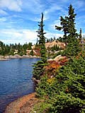
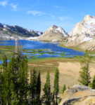
From here, we retraced our steps to the cairned (true) trail up to Lookout No. 2 and proceeded to rise on nicely graded switchbacks, surrounded by alpine meadows and magnificent views. On top, we found some remnants of the old lookout and then proceeded to drop to Lake 6380. We traversed under the Garcia Glacier and dropped to our final destination -- the sunny shores of Springer Lakes.  Thursday, we spent a warm and sunny day floating and fishing, swimming and relaxing around the area. We also found that we were sharing the lakes with a fellow NWHiker, RayD! A few large clouds drifted over temporarily, but for the most part we enjoyed good weather.
Friday, we packed up and headed out of camp about 10am. On the way home, we rose to the col at 7200' and met up with Ray again. Together, we traversed under Crater Mountain to reach the trail to Lookout No. 1. There, we parted ways...Tom and I heading up Crater and Ray heading back toward the trailhead.
The trail up Crater to Lookout No. 1 is amazing, to put it lightly. It's a well engineered trail switchbacking up some seriously steep terrain. A few hundred feet from the top the trail turns into a decent Class 3 scramble up a chossy gully and a cool ledge system to reach the false summit. From the false summit, the engineered trail resumes and switchbacks up the last 100 feet to the true summit. Great views of Jack, the north end of the Ptarmigan Traverse and south end of the Pickets from up there.
Thursday, we spent a warm and sunny day floating and fishing, swimming and relaxing around the area. We also found that we were sharing the lakes with a fellow NWHiker, RayD! A few large clouds drifted over temporarily, but for the most part we enjoyed good weather.
Friday, we packed up and headed out of camp about 10am. On the way home, we rose to the col at 7200' and met up with Ray again. Together, we traversed under Crater Mountain to reach the trail to Lookout No. 1. There, we parted ways...Tom and I heading up Crater and Ray heading back toward the trailhead.
The trail up Crater to Lookout No. 1 is amazing, to put it lightly. It's a well engineered trail switchbacking up some seriously steep terrain. A few hundred feet from the top the trail turns into a decent Class 3 scramble up a chossy gully and a cool ledge system to reach the false summit. From the false summit, the engineered trail resumes and switchbacks up the last 100 feet to the true summit. Great views of Jack, the north end of the Ptarmigan Traverse and south end of the Pickets from up there.  Tom and I hung out on the summit for a good half hour and then headed down shortly after 3pm. After downclimbing the scramble portion, we made pretty good time all the way to the bottom and crawled into our car at 7:05pm.
(pics are on their way)
Tom and I hung out on the summit for a good half hour and then headed down shortly after 3pm. After downclimbing the scramble portion, we made pretty good time all the way to the bottom and crawled into our car at 7:05pm.
(pics are on their way)
"There is only one basic human right, the right to do as you damn well please. And with it comes the only basic human duty, the duty to take the consequences." -P.J. O'Rourke
"Ignorance is natural. Stupidity takes commitment." -Solomon Short
"There is only one basic human right, the right to do as you damn well please. And with it comes the only basic human duty, the duty to take the consequences." -P.J. O'Rourke
"Ignorance is natural. Stupidity takes commitment." -Solomon Short
|
| Back to top |
  
|
|
Tom
Admin
Joined: 15 Dec 2001
Posts: 17857 | TRs | Pics
|
|
Tom
Admin
|
 Sun Aug 26, 2007 7:42 pm |
|
|
Thanks for writing the TR Mike. Beautiful area but don't expect solitude. We counted 14 people (including us) camped at the lakes - midweek.  A couple more items to note. While descending to the Jerrys we passed by an upper tarn which we mistook for the uppermost lake in our state of exhaustion and haste to set up camp. It wasn't until we were looking down on the lakes from Crater Mtn that we realized we never visited the higher lake. A couple more items to note. While descending to the Jerrys we passed by an upper tarn which we mistook for the uppermost lake in our state of exhaustion and haste to set up camp. It wasn't until we were looking down on the lakes from Crater Mtn that we realized we never visited the higher lake.  I would also describe the scramble up to the summit of Crater as class 3.14159. I do pretty well with exposure but for some reason it really freaked me out. Not recommended for the faint of heart. Here are my pics. I would also describe the scramble up to the summit of Crater as class 3.14159. I do pretty well with exposure but for some reason it really freaked me out. Not recommended for the faint of heart. Here are my pics.
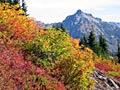
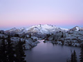
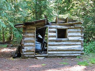 Collapsing Cabin at Start of Trail 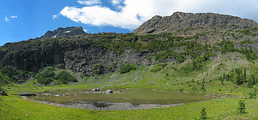 Arriving at Crater Lake 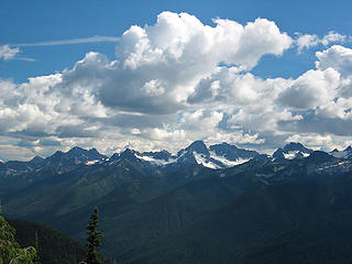 Ragged Ridge from Lookout No 2 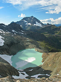 Lake 6380 and Jack Mtn 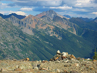 Silver Star? from Lookout No 2 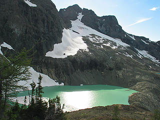 Descending to Lake 6380 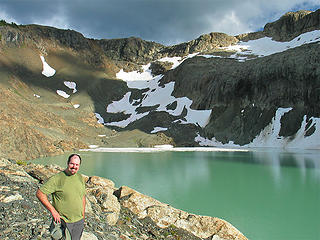 Mike at Lake 6380 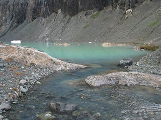 Lake 6380 from Outlet 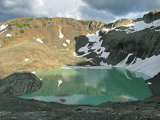 Leaving Lake 6380 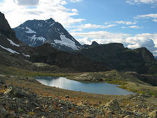 Small Tarn and Jack Mtn 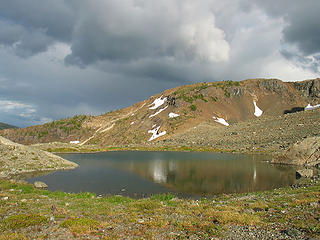 Small Tarn below Jerry Glacier 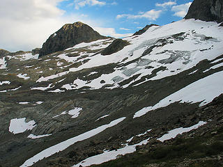 Looking Back to Jerry Glacier from Pass 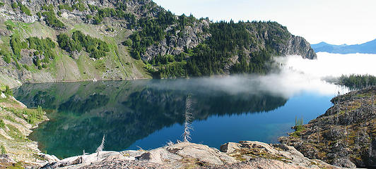 Lower Jerry from Knoll 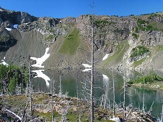 Upper Jerry from Knoll 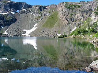 Upper Jerry from Cove 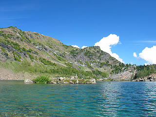 Upper Jerry Island from Raft 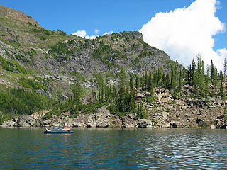 Mike Rafting Upper Jerry 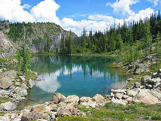 Middle Jerry 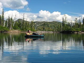 Mike Rafting Lower Jerry 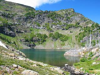 Lower Jerry from Inlet 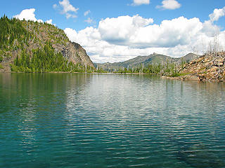 Lower Jerry and Devils Park 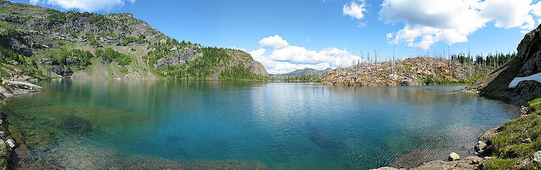 Lower Jerry Pano 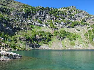 Point 6835 and Lower Jerry 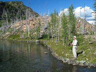 Ray D Fishing Upper Jerry 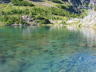 Upper Jerry Cove 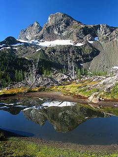 Crater Mtn and Knoll Tarn 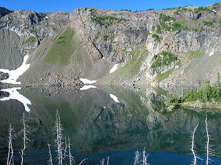 Upper Jerry Reflections 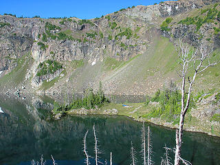 Upper Jerry and Camp 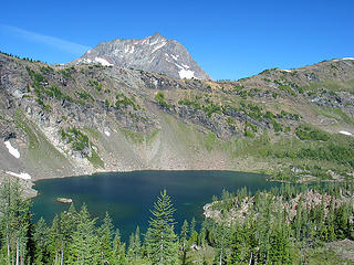 Leaving Upper Jerry 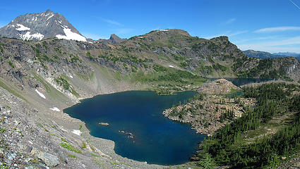 Jerry Lakes from Pass 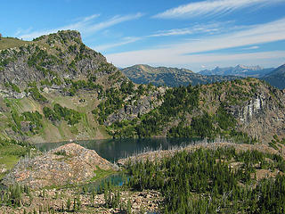 Lower Jerry from Pass 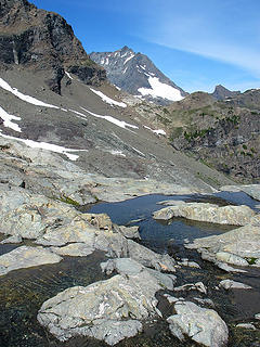 Jack and Glacial Pools below Jerry Glacier 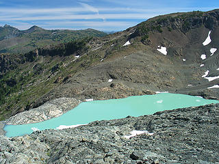 Lake 6380 from Ascent to 7150' Pass 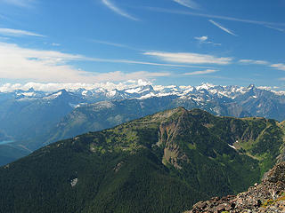 Diablo Lake and Northern Pickets from Crater 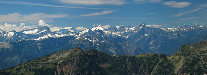 Baker and Northern Pickets from Crater 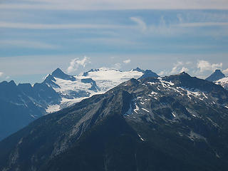 Snowfield, Ruby, and Paul Bunyan's Stump from Crater 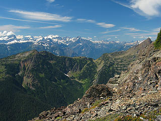 McMillan to Canada from Crater 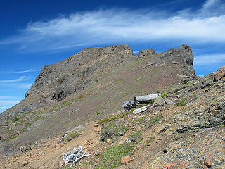 Approaching Crater Summit 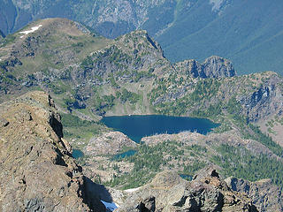 Jerry Lakes from Crater Mtn 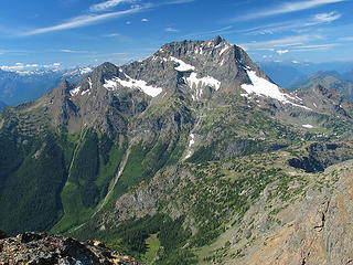 Jack from Crater Mtn 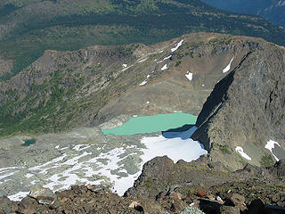 Small Tarn and Lake 6380 from Crater Mtn 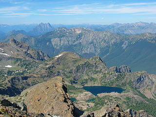 Hozomeen and Jerry Lakes from Crater Mtn 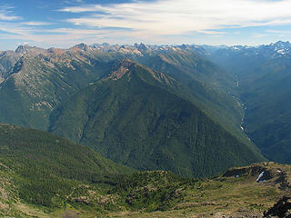 North Cascades Highway from Crater Mtn 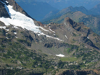 Glacier and Waterfalls on East Shoulder of Jack
|
| Back to top |
|
|
Mtn Dog
Technohiker

Joined: 01 Aug 2004
Posts: 3336 | TRs | Pics
Location: Bellevue, WA |
|
Mtn Dog
Technohiker
|
Sun Aug 26, 2007 8:01 pm |
|
|
You guys rock! It's great to reminisce on that area seeing pics of it again just a few weeks later. The snow around the Jerry Glacier has definitely melted some from a few weeks ago. You also got a better view of the Northern Pickets (there were more clouds up that way when we were there). We had too many clouds blocking the view of Mt Baker. I wondered if that was Hozomeen Mtn or not and I loved the peekaboo view of Ross Lake to the left of it behind Jack Mtn. What a great hike!
The Class 3 section is a bit challenging. I was prepared for it having read about it in the guide ahead of time but I was also quite relieved when we got back on normal trail for the last several hundred feet of ascent - mostly because the scramble took a bit longer and was costing us time. They did a great job of marking the route, IMO.
Footprints on the sands of time will never be made sitting down.
Footprints on the sands of time will never be made sitting down.
|
| Back to top |
|
|
Dayhike Mike
Bad MFKer
Joined: 02 Mar 2003
Posts: 10958 | TRs | Pics
Location: Going to Tukwila |
| Mtn Dog wrote: | | They did a great job of marking the route, IMO. |
Wholeheartedly agree. And, again, can't emphasize enough how impressed I was with that trail. Perfect grade, great condition, etc.
Knees were sore when we got down and I'm still a little stiff today. That's a lot of elevation.
"There is only one basic human right, the right to do as you damn well please. And with it comes the only basic human duty, the duty to take the consequences." -P.J. O'Rourke
"Ignorance is natural. Stupidity takes commitment." -Solomon Short
"There is only one basic human right, the right to do as you damn well please. And with it comes the only basic human duty, the duty to take the consequences." -P.J. O'Rourke
"Ignorance is natural. Stupidity takes commitment." -Solomon Short
|
| Back to top |
|
|
David¹
Token Canadian

Joined: 25 Jul 2002
Posts: 3040 | TRs | Pics
Location: The Great White North |
|
David¹
Token Canadian
|
Sun Aug 26, 2007 8:13 pm |
|
|
Impressive
Best pics I've ever seen of Jerry Lakes 
|
| Back to top |
|
|
GeoTom
Member

Joined: 19 May 2005
Posts: 3215 | TRs | Pics
Location: Earth |
|
GeoTom
Member
|
Sun Aug 26, 2007 8:25 pm |
|
|
Thanks guys
|
| Back to top |
|
|
Mtn Dog
Technohiker
Joined: 01 Aug 2004
Posts: 3336 | TRs | Pics
Location: Bellevue, WA |
|
Mtn Dog
Technohiker
|
Sun Aug 26, 2007 8:27 pm |
|
|
| Dayhike Mike wrote: | | Knees were sore when we got down and I'm still a little stiff today. That's a lot of elevation. |
My feet were sore after that too, dropping 6,100' in about the same time as you guys did. My brother led the way down and pushed me a bit to keep up with him. But I have to agree too, the gradient was perfect and made for great hiking. I figured it averaged out to about 15%.
Footprints on the sands of time will never be made sitting down.
Footprints on the sands of time will never be made sitting down.
|
| Back to top |
|
|
RayD
the griz ate my pass
Joined: 20 Aug 2005
Posts: 1763 | TRs | Pics
Location: Vacaville |
|
RayD
the griz ate my pass
|
Sun Aug 26, 2007 8:29 pm |
|
|
It was splendid to meet Tom and Mike! Here are a few pics although I'm almost ashamed to post them after Tom's beauties.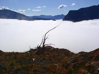 JerrryLakes 025 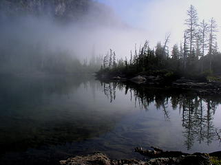 JerrryLakes 023 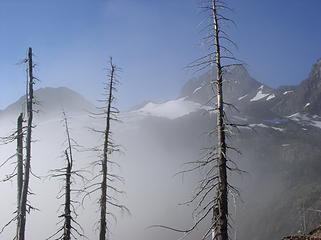 JerrryLakes 021 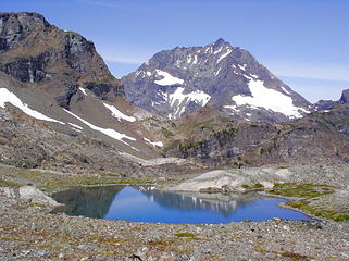 JerrryLakes 050 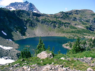 JerrryLakes 040 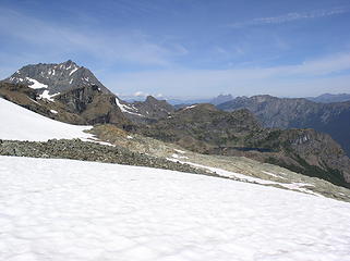 JerrryLakes 054 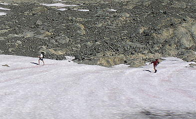 JerrryLakes 057
don't believe everything you think
don't believe everything you think
|
| Back to top |
|
|
RayD
the griz ate my pass
Joined: 20 Aug 2005
Posts: 1763 | TRs | Pics
Location: Vacaville |
|
RayD
the griz ate my pass
|
Sun Aug 26, 2007 8:37 pm |
|
|
| Quote: | | I would also describe the scramble up to the summit of Crater as class 3.14159. |
A piece of pie?
don't believe everything you think
don't believe everything you think
|
| Back to top |
|
|
Backpacker Joe
Blind Hiker

Joined: 16 Dec 2001
Posts: 23956 | TRs | Pics
Location: Cle Elum |
Why were you guys scrambling up anything???? The route goes in between the two peaks......
"If destruction be our lot we must ourselves be its author and finisher. As a nation of freemen we must live through all time or die by suicide."
Abraham Lincoln
"If destruction be our lot we must ourselves be its author and finisher. As a nation of freemen we must live through all time or die by suicide."
Abraham Lincoln
|
| Back to top |
|
|
Tom
Admin
Joined: 15 Dec 2001
Posts: 17857 | TRs | Pics
|
|
Tom
Admin
|
Sun Aug 26, 2007 8:40 pm |
|
|
BPJ, it made sense for us to go in the way we did for several reasons. First, we didn't want to bring ice axe or crampons and we knew our route in would bypass the glacier. We also wanted to climb Crater on the way out so it worked out perfectly to loop out that way after being able to judge glacier conditions. FWIW, I did the entire route in running shoes and trekking poles. As far as the exposure, it's on the scramble up Crater Mtn. One slip and you're a goner.
|
| Back to top |
|
|
seawallrunner
dilettante

Joined: 27 Apr 2005
Posts: 3308 | TRs | Pics
Location: Lotusland |
wow Mike and Tom - what a great TR and what awesome photos! I heard that Granite was a tough climb (Gary Snyder manned the lookout there, in the 50s) but it's cool to hear that there is a trail.
Dunno about that scramble before the summit though. I get vertigo just thinking about it!
Well done guys!
|
| Back to top |
|
|
Tom
Admin
Joined: 15 Dec 2001
Posts: 17857 | TRs | Pics
|
|
Tom
Admin
|
Sun Aug 26, 2007 8:45 pm |
|
|
| RayD wrote: | | Quote: | | I would also describe the scramble up to the summit of Crater as class 3.14159. |
A piece of pie? |
Oops, that should have read higher than.
|
| Back to top |
|
|
Backpacker Joe
Blind Hiker
Joined: 16 Dec 2001
Posts: 23956 | TRs | Pics
Location: Cle Elum |
Thanks Tom. Based on our trip last year and my exposer problem I guess its good I didnt go with you guys on this one.... Bummer though.
I really liked that route to the 7200' pass between the two peaks. It looks (from your pics) like there was more snow on the back side of that pass than there was two years ago when Dan and I went.
"If destruction be our lot we must ourselves be its author and finisher. As a nation of freemen we must live through all time or die by suicide."
Abraham Lincoln
"If destruction be our lot we must ourselves be its author and finisher. As a nation of freemen we must live through all time or die by suicide."
Abraham Lincoln
|
| Back to top |
|
|
Mtn Dog
Technohiker
Joined: 01 Aug 2004
Posts: 3336 | TRs | Pics
Location: Bellevue, WA |
|
Mtn Dog
Technohiker
|
Sun Aug 26, 2007 8:47 pm |
|
|
BPJ, the trail ascends to Crater Mtn summit and lookout No. 1 via a Class 3 scramble between 7,330 and 7,670'. It's just below the false summit and it's marked by yellow + signs in O's and arrows painted onto the rock. Fred Beckey refers to it in his guide. The summit is at 8,128'.
Footprints on the sands of time will never be made sitting down.
Footprints on the sands of time will never be made sitting down.
|
| Back to top |
|
|
|
|


