| Previous :: Next Topic |
| Author |
Message |
Yana
Hater


Joined: 04 Jun 2004
Posts: 4212 | TRs | Pics
Location: Out Hating |
|
Yana
Hater
|
 Mon Apr 06, 2009 10:19 pm |
|
|
Previously, on "As the Spring Break Turns": our intrepid (stupid?  ) adventurers were running (okay, driving) for their lives from a brutal spring storm in the desert of southern Utah.
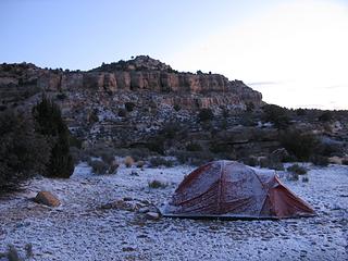
Hole in the Rock road, for much of its length, is paralleled on one side by the Straight Cliffs (which seems like a weird name, but it makes sense once you see them). The prominent winds seem to be coming from over there, so we decided to head toward them on a spur road in the hopes of finding some shelter. We headed toward a place labeled on my Trails Illustrated map as Batty Pass Caves, but as soon as I saw the name, I transliterated it into Fatty Ass Caves for the duration of our stay. Anyway, caves sound sheltered, don't they? We didn't find the caves, but the wind did seem to be less hurricane-like. Tazz was sleeping in her vehicle, and Liz and I found a nearby windbreak to put the tent behind. Pretty much as soon as we finished setting up the tent, it began snowing rather heavily. ) adventurers were running (okay, driving) for their lives from a brutal spring storm in the desert of southern Utah.
Hole in the Rock road, for much of its length, is paralleled on one side by the Straight Cliffs (which seems like a weird name, but it makes sense once you see them). The prominent winds seem to be coming from over there, so we decided to head toward them on a spur road in the hopes of finding some shelter. We headed toward a place labeled on my Trails Illustrated map as Batty Pass Caves, but as soon as I saw the name, I transliterated it into Fatty Ass Caves for the duration of our stay. Anyway, caves sound sheltered, don't they? We didn't find the caves, but the wind did seem to be less hurricane-like. Tazz was sleeping in her vehicle, and Liz and I found a nearby windbreak to put the tent behind. Pretty much as soon as we finished setting up the tent, it began snowing rather heavily.  Didn't we come here to get away from the snow? It was 50 degrees when it started snowing, so I didn't think it would stick. However, when I got up early the next morning, I found this: Didn't we come here to get away from the snow? It was 50 degrees when it started snowing, so I didn't think it would stick. However, when I got up early the next morning, I found this:
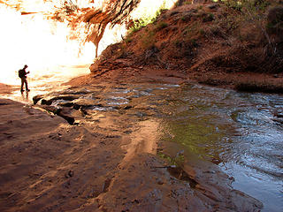
 The morning after the snowstorm 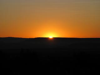 Sunrise 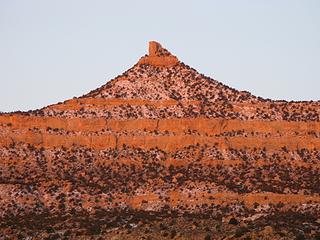 Straight Cliffs at sunrise 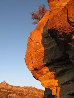 Good morning, sunshine! 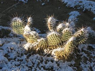 Snow decorated cactus 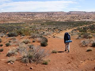 Descending from Red Well 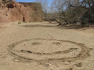 Strange Desert Scrawl 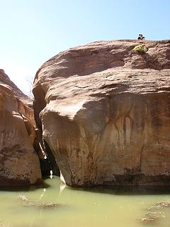 Liz takes a break  I managed to disengage myself and rejoin the others. We walked on. The canyon changes character from here on out - the walls get closer in and increase in height. The stream has carved out many an amphitheater out of the soft sandstone.
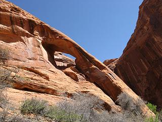
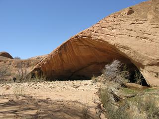 Anne admires the Mothership 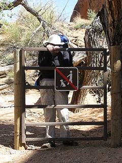 Disregarding the sign 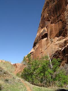 Redwall and green plants 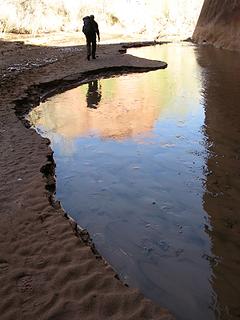 Coyote Gulch Reflection 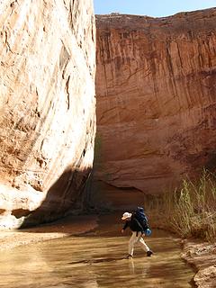 Liz on one of the MANY creek crossings in Coyote Gulch 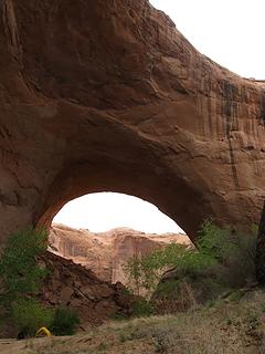 Jacob Hamblin/Lobo Arch  The next morning, we packed our daypacks and set off downcanyon. We hoped to make it all the way to the Escalante River five miles downstream. Again, the scenery just kept getting better and better. We ambled along slowly, taking in the views. Along the way, we saw a gigantic overhang that was so flat and of such size that you could have a nice game of soccer under there. The stream, which is about 200 feet away, sounded like it was rushing down the canyon wall. Not much past this, you come to an amazing natural bridge. Natural bridges are different than arches because they are formed by streams, so you get to walk through them.
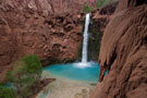
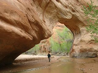 Natural Bridge in Coyote Gulch 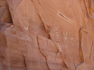 Petroglyphs  Mildly disturbed by these events, we nonetheless pushed on. Not far after the petroglyphs, the trail climbs out of the streambed to go around some difficulties. Though the canyon bottom is certainly spectacular, it's nice to get a view from a higher perch. Shy Cliff Arch is visible from here, as well as the first of several small waterfalls along Coyote Gulch.
 Cliff Arch 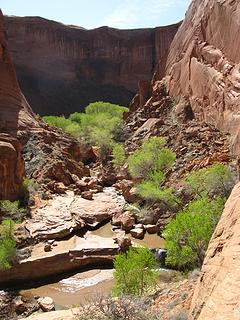 Coyote Gulch and greenery 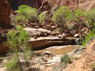 Coyote Gulch 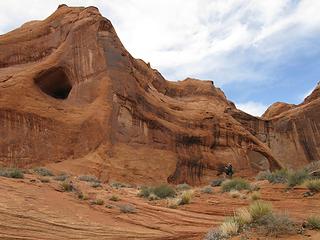 Anne and Cliff Arch 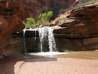 Waterfall 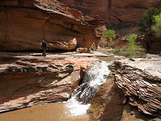 Anne looks for a way around the waterfall 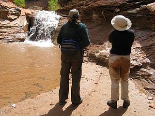 Clay butts admire the waterfall we had to climb around 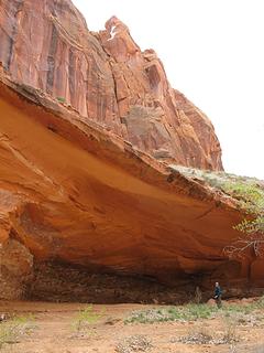 One of many overhangs in the canyon 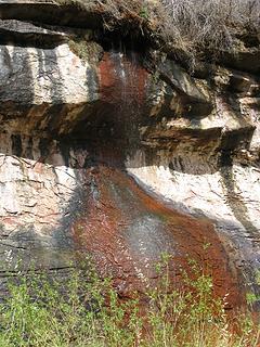 Colors 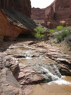 Lower Coyote Gulch 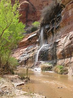 Waterfall in lower Coyote Gulch 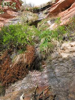 Greenery 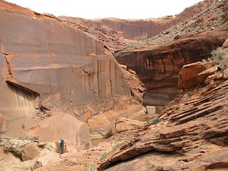 Our turnaround point in Coyote Gulch 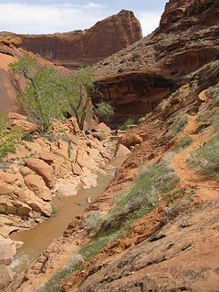 Anne in lower Coyote Gulch  We had only passed two parties on this stretch - one heading upstream (who knew we were dayhiking and coming back that way) and one heading downstream (who should have given back the damn thing if they'd taken it). GRRRRR. Luckily, it wasn't necessary for the climb out, though it would have been nice to have.
The hike back to camp was quicker, but still not a pace I would consider very fast, despite the fact that we didn't linger as much. The canyons - they do things to you. Well, that's my excuse anyway. We had only passed two parties on this stretch - one heading upstream (who knew we were dayhiking and coming back that way) and one heading downstream (who should have given back the damn thing if they'd taken it). GRRRRR. Luckily, it wasn't necessary for the climb out, though it would have been nice to have.
The hike back to camp was quicker, but still not a pace I would consider very fast, despite the fact that we didn't linger as much. The canyons - they do things to you. Well, that's my excuse anyway.  I haven't felt this tired from a dayhike in a long time - and we only went 9 miles!
However, the day's excitement wasn't over yet. When we got back to camp, we discovered that something had gotten into our food.
I haven't felt this tired from a dayhike in a long time - and we only went 9 miles!
However, the day's excitement wasn't over yet. When we got back to camp, we discovered that something had gotten into our food.
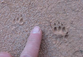 Tracks of evil Reece's Peanut Butter Cup eating rodent  I hadn't wanted to hang the food for the day as there were crows around. But now I no longer wanted to keep it in the pack overnight, either. No problem, I'll hang it for the night, right? Right! Where's my rope... oh... that's right, some jerk took that, too! I had to borrow Tazz's short handline to hang the food.
After all that excitement, we set out to enjoying a lovely, quiet evening in camp... or so we thought. About an hour before sunset, we hear loud talking from above. Then we hear yells of "ROCK" and a splash in the stream. WTF?!!?!??! A quick trip downstream to the fancy new composting toilet revealed the situation: a very large group (very much over the 12 person party limit) composed mainly of teenagers was being belayed down the slabby face above our campsite, one by one.
I hadn't wanted to hang the food for the day as there were crows around. But now I no longer wanted to keep it in the pack overnight, either. No problem, I'll hang it for the night, right? Right! Where's my rope... oh... that's right, some jerk took that, too! I had to borrow Tazz's short handline to hang the food.
After all that excitement, we set out to enjoying a lovely, quiet evening in camp... or so we thought. About an hour before sunset, we hear loud talking from above. Then we hear yells of "ROCK" and a splash in the stream. WTF?!!?!??! A quick trip downstream to the fancy new composting toilet revealed the situation: a very large group (very much over the 12 person party limit) composed mainly of teenagers was being belayed down the slabby face above our campsite, one by one.   I'm not sure why as there are many much easier ways into the canyon. Some of them were also having their packs lowered (the one I witnessed kept having things like water bottles and what looked like a stove fall off and tumble on down). Oh, did I mention it was getting dark? It really looked like an accident waiting to happen. Liz and I went to sleep before the whole thing was entirely over, but Tazz apparently got some strange shadow theater on the canyon wall for much of the evening. She reported the next morning that everyone had gotten down safely around 11 pm.
I woke up the next morning and was still in awe of the stupendous arch that dominates the view. I don't think I could ever get tired of waking up to that. Alas, it was time to leave. We packed up and started out at 9 am under strangely cloudy skies (the forecast called for sun) and a rather strong breeze. It even snowed for a little while. However, the lighting was better on the way out and so I was forced to take more photos. I'm not sure why as there are many much easier ways into the canyon. Some of them were also having their packs lowered (the one I witnessed kept having things like water bottles and what looked like a stove fall off and tumble on down). Oh, did I mention it was getting dark? It really looked like an accident waiting to happen. Liz and I went to sleep before the whole thing was entirely over, but Tazz apparently got some strange shadow theater on the canyon wall for much of the evening. She reported the next morning that everyone had gotten down safely around 11 pm.
I woke up the next morning and was still in awe of the stupendous arch that dominates the view. I don't think I could ever get tired of waking up to that. Alas, it was time to leave. We packed up and started out at 9 am under strangely cloudy skies (the forecast called for sun) and a rather strong breeze. It even snowed for a little while. However, the lighting was better on the way out and so I was forced to take more photos.
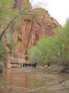 Conga Line on the way out of Coyote Gulch 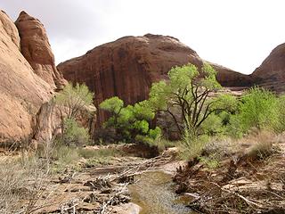 Coyote Gulch 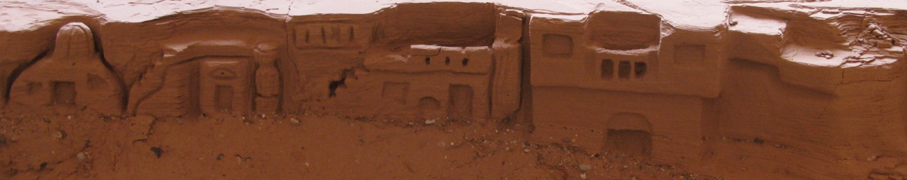 Ancient Anasazi Dwellings 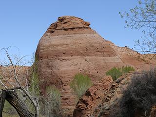 Beehive 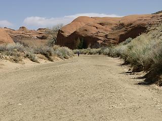 The dry portion before Coyote Gulch
PLAY SAFE! SKI ONLY IN CLOCKWISE DIRECTION! LET'S ALL HAVE FUN TOGETHER!
PLAY SAFE! SKI ONLY IN CLOCKWISE DIRECTION! LET'S ALL HAVE FUN TOGETHER!
|
| Back to top |
  
|
|
silly_traveler
~ roaming ~

Joined: 04 Jun 2006
Posts: 1525 | TRs | Pics
Location: Bellevue |
♫ You have brains in your head. You have feet in your shoes. You can steer yourself any direction you choose. And you're the one who will decide where you'll go. Oh the places you'll go. - Dr. Seuss
|
| Back to top |
|
|
Matt
Tea, Earl Grey, Hot

Joined: 30 Jan 2007
Posts: 4308 | TRs | Pics
Location: Shoreline |
|
Matt
Tea, Earl Grey, Hot
|
Tue Apr 07, 2009 1:21 am |
|
|
Great reports. Keep them coming.
As beacons mountains burned at evening. J.R.R. Tolkien
As beacons mountains burned at evening. J.R.R. Tolkien
|
| Back to top |
|
|
Tazz
Member

Joined: 27 Apr 2005
Posts: 7902 | TRs | Pics
|
|
Tazz
Member
|
Tue Apr 07, 2009 6:32 am |
|
|
Warning! I took over 300 images on this 3 day trip and I have many to share  . I apologize again for too many pics but for me a pic is worth a thousand words and I love to share the sw utah experience! Enjoy...
Another great report yana! What a great writeup, idea, and trip! Thanks! Great images! I love the reflection shot! . I apologize again for too many pics but for me a pic is worth a thousand words and I love to share the sw utah experience! Enjoy...
Another great report yana! What a great writeup, idea, and trip! Thanks! Great images! I love the reflection shot!
| Quote: | | Things I learned: 1. Just because there is no elevation gain does not mean it won't kick your ass. 2. Walking in sand sucks your soul away. 3. Canyons are absolutely awesome. 4. If you don't meet someone from Washington at least once every day, something is wrong. 5. I can make people do strenuous, unpleasant walking, and they love it and thank me for suggesting the trip! lol.gif |
I will add to that:
6. Your feet will get wet, oh yes they will. No matter what you do to avoid it. 7. I uncontrollably spit out Wow, sweet, cool, beautiful, awesome, and so on at least every 3-5 minutes, when in the sw canyons! 8. I am not alone when i moo at cows! MOO!!!
Yana yes you can torture me with trips like this any time! this trip was one I had never done any research on and knew nothing of. maybe because I try and avoid busy places.
This hike had it all. Great folks to share it with. route finding for the best crossings, 500 stream crossings, Soul sucking sand hiking (the soul revives quick with the surrounding beauty so it is not as bad), rock scrambling and MOO! Views change by the minute!
here are the pics from the hike in on day one. The canyon changed so much and there is so much to share!  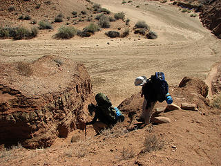 entrance into the wash 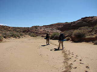 SOUL SUCKING SAND hiking for 3 days! whoo hoo!! 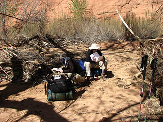 this one says 2 miles, no way we have only done 2 miles. 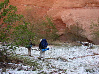 what snow? 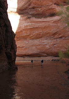 walking on water # 45 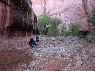 crosdsing 221 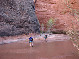 crossing # 234 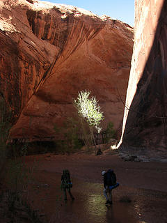 crossing # 378 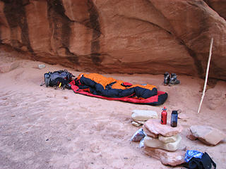 my house 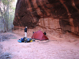 yana and Liz house 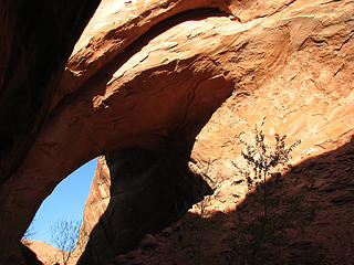 view from my bivy in the morning.
|
| Back to top |
|
|
Randy
Cube Rat

Joined: 18 Dec 2001
Posts: 2910 | TRs | Pics
Location: Near the Siamangs |
|
Randy
Cube Rat
|
Tue Apr 07, 2009 8:37 am |
|
|
Very cool and motivating. I'll be down there in May in the heat.
|
| Back to top |
|
|
ree
Member

Joined: 29 Jun 2004
Posts: 4399 | TRs | Pics
|
|
ree
Member
|
Tue Apr 07, 2009 3:24 pm |
|
|
Beautiful pictures, ladies.
What a fun trip! So you didn't make it all the way to Hole In The Rock?
The road's supposed to be so nasty down there.
|
| Back to top |
|
|
Tazz
Member
Joined: 27 Apr 2005
Posts: 7902 | TRs | Pics
|
|
Tazz
Member
|
Tue Apr 07, 2009 3:29 pm |
|
|
a few from day 2 the rest are coming...
 Yana at yet another crossing. 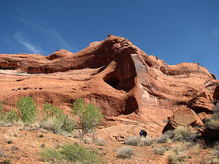 the gals 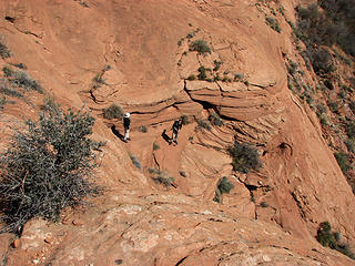 descent down the friction slab to the stream 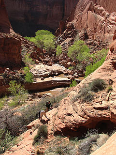 building carns for return trip. 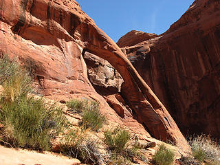 cliff arch
|
| Back to top |
|
|
Yana
Hater
Joined: 04 Jun 2004
Posts: 4212 | TRs | Pics
Location: Out Hating |
|
Yana
Hater
|
Tue Apr 07, 2009 3:32 pm |
|
|
Hey, Tazz, I hate to be a nitpicker, but I think crossing #378 was actually crossing #341. Great photos! The colors are so vivid in your pictures.
ree - no, did not make it to Hole in the Rock. The info we had suggested that most of the road up to seven miles from the end is pretty reasonable. I guess we could have tried it with the Subaru but none of us really had the desire to drive all the way out there.
PLAY SAFE! SKI ONLY IN CLOCKWISE DIRECTION! LET'S ALL HAVE FUN TOGETHER!
PLAY SAFE! SKI ONLY IN CLOCKWISE DIRECTION! LET'S ALL HAVE FUN TOGETHER!
|
| Back to top |
|
|
Tazz
Member
Joined: 27 Apr 2005
Posts: 7902 | TRs | Pics
|
|
Tazz
Member
|
Tue Apr 07, 2009 3:38 pm |
|
|
|
| Back to top |
|
|
Karen²
A Real Canadian Girl
Joined: 25 Jul 2002
Posts: 1367 | TRs | Pics
Location: Behind the Lens |
|
Karen²
A Real Canadian Girl
|
Tue Apr 07, 2009 5:43 pm |
|
|
 Great stuff, I am enjoying this travelogue immensely. The photos are awesome!
|
| Back to top |
|
|
Matt
Tea, Earl Grey, Hot
Joined: 30 Jan 2007
Posts: 4308 | TRs | Pics
Location: Shoreline |
|
Matt
Tea, Earl Grey, Hot
|
Wed Apr 08, 2009 11:15 pm |
|
|
I really like the contrast of the bits of greenery amid the big rock walls in your photos. Fascinating also to see the small stream in the midst of the huge course it has carved.
Are you trying to imply that the sand made for difficult walking?
As beacons mountains burned at evening. J.R.R. Tolkien
As beacons mountains burned at evening. J.R.R. Tolkien
|
| Back to top |
|
|
Go Jo
of the lykkens

Joined: 08 Jun 2003
Posts: 2248 | TRs | Pics
Location: Around The Bend |
|
Go Jo
of the lykkens
|
Thu Apr 09, 2009 12:05 am |
|
|
It's like you dropped onto another planet with these photos,
it's difficult to imagine while looking out the window here.
Great write-up, fantastic visuals, thanks for sharing. ~Jo
|
| Back to top |
|
|
Hikingqueen
Member

Joined: 12 Nov 2007
Posts: 2946 | TRs | Pics
|
What a magical place, I must go to Utah and explore. Maybe next month. Lovely photos, landscape is ever changing.
|
| Back to top |
|
|
Bedivere
Why Do Witches Burn?

Joined: 25 Jul 2008
Posts: 7464 | TRs | Pics
Location: The Hermitage |
|
Bedivere
Why Do Witches Burn?
|
Thu Apr 09, 2009 2:25 pm |
|
|
After talking with Tazz Tuesday I'm going through and finding all these TRs. I've been wanting to head to Utah for awhile, what amazing country.
Drawings & petroglyphs like this always make me wonder:
Who put that there? How long ago? What was the purpose? What story were they trying to convey, and to whom? Did they have any idea that hundreds of years in the future some traveler would see it?
|
| Back to top |
|
|
Yana's Dad
Member

Joined: 22 Aug 2007
Posts: 53 | TRs | Pics
Location: Orange, So Cal |
Why go to canyons?
Here is what Kathy and Craig Copeland say about this in their book "Utah Canyon Country", Wilderness Press, 2008, p. 360.
"The difference between ascending a mountain and probing a canyon is the difference between the ego and the id."
"Attaining a summit is celebratory. 'Wahoo', you say, 'We made it!' Standing in the recesses of a canyon is meditative. 'Whoa' you whisper, 'This is cool.'"
"The experience mirrors the topography, of course. Mountains are the earth's extroverts. Canyons are their opposite, the introverts."
"... you realize that this great abyss isn't shaking its clenched fist in the air, defying the heavens, daring you to challenge it. Here, the earth is open, silent, submissive, patiently awaiting your entry."
"Mountains talk, canyons listen."
My daughter Yana did Coyote Gulch via Red Well in the very end of March 2009; here is her TR: https://www.nwhikers.net/forums/viewtopic.php?p=486342&highlight=#486342.
I listened to Yana's advice to also walk down Coyote Gulch in Utah. Before that, my plan was to use my spring break for a trip down the remote Salt Creek in Canyonlands NP. To Yana, that did not seem a reasonable plan because I was to go with a 9 years old Alex Norris for whom this would be a first backpacking trip ever. Besides, spring snow covered the upper part of the Salt Creek route, including the 7000 ft high 4WD road to the trailhead. The outfitter I had contracted earlier called to tell me they could not deliver us to the trailhead.
This is how we ended up going to Coyote Gulch in Escalante instead to Salt Creek in Canyonlands (both are in Southern Utah). Beside me, our group included my wife Roumi, our daughter Boyana, and her son Alex (none of them are nwhikers.net members). We did this trip in three days only one week after Yana, Liz Thomas, and 'Tazz' Anne Arnoldy.
Our trip differed in two ways from the trip of Yana and Co. First, we had really good weather during most of the trip, except for our day out when we were subject to the infamous sandy wind, already described by Yana. We had cloudless skies and nearly full moon. Second, we went down and up along Hurricane wash - as very reasonably suggested by Yana - instead of Red Well.
It takes 5 miles walking down Hurricane Wash to reach Coyote Gulch. Initially the wash is uninteresting but later it becomes quite scenic. There are a couple of narrow sections in the lower part of Hurricane that can be dangerous when it rains.
Here are some pictures from our walk down Hurricane Wash.
After the confluence of Hurricane and Coyote, we walked three more miles to Jacob Hamblin arch. This is an amazing place, the arch itself not being the only interesting canyon feature. The arch is in the neck of a small peninsula which causes the creek to meander in about 180 degrees. Opposite to the peninsula, the creek has formed a giant overhang - giant in any respect. That overhang compares to nothing - one should see it to appreciate.
Here are pictures from our walk along Coyote Gulch and from the Jacob Hamblin arch area.
Immediately after the Jacob Hamblin arch, we passed by the campsite used a week ago by Yana, Liz, and Tazz, and continued downstream for about a mile to reach a very pleasant campsite as recommended by Yana and her companions. This was certainly a most pleasant place to camp.
Here are some pictures from our Camp 1.
On the second day, we day hiked down the gulch by passing the Coyote Natural Bridge, then Cliff Arch and three nice waterfalls. We turned back at the third waterfall where Yana's party used their buts and a rope to descend in the creek, and where they had their rope stolen. We decided to spare our rope (and buts, too) and turned back at that same spot.
Here are some pictures from our walk down Coyote Gulch, the Coyote Natural Bridge, Cliff Arch and the waterfalls.
We went back to our camp, packed, and waked upstream to the confluence of Coyote and Hurricane. This was another great place to camp.
Here are some pictures from our Camp 2.
Next morning, it did not take us too long to hike the 5 miles up Hurricane, despite of the strong headwind.
Here are some pictures from our walk up Hurricane Wash.
Apart from tramping in Hurricane and Coyote, we visited - as Yana's party did - some pleasant slots in the Coyote Dry Fork (along the Hole in the Rock road) and the Devil's Garden. We had moderate ambitions and did not really explore Peek-a-boo, but enjoyed Spooky and North Fork.
Here are some pictures from the slots.
We also went to see some petrified trees in the Escalante Petrified Forest State Park. See pictures below.
Thank you, Yana, for suggesting this itinerary. It made for a very pleasant trip.
|
| Back to top |
|
|
|
|
You cannot post new topics in this forum
You cannot reply to topics in this forum
You cannot edit your posts in this forum
You cannot delete your posts in this forum
You cannot vote in polls in this forum
|
Disclosure: As an Amazon Associate NWHikers.net earns from qualifying purchases when you use our link(s). |


 Love the green stuff in the canyons


 referring to my mental notes it also may be crossing 268!
  hey randy you have to go in April to experience the snow! Don't ya wanna see some snow!
  if ya need any tips give me a shout.


