| Previous :: Next Topic |
| Author |
Message |
rubywrangler
Member


Joined: 04 Aug 2015
Posts: 511 | TRs | Pics
|
After a month of dogless climbing trips I was ready for something Ruby-friendly and a little more ramble-y. Caltopo and browsing TRs on Friday morning led me to this spot. A nice, long ridge scramble sounded good. Off we went.
I had never visited the WFF before. Definitely more interesting and less of a death march than the east fork. We got to Big Heart Lake sometime after 7pm. I was hoping to make it to the 5300' tarn at the end of Atrium ridge so we kept moving. Got to where there should be a turn off to head up the ridge, but didnt see anything. Due to the amount of traffic, I expected this to be marked, or at least easy to find. So I dithered a bit looking around, one false start, generally wasting time while the sun was starting to set, and realized we might not have enough daylight to make it all the way to the tarn. Backtracked to a mosquito incubation pond a bit lower to get water then tried again. Spotted an out-of-place looking rock about 50' upslope so headed that way, and immediately found the bootpath. I wonder if the main trail wraps around and meets the ridge trail at some point? I didn't see any footprints on the first section of the ridge although there were a few folks ahead of me as I would learn the next morning.
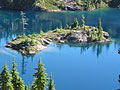
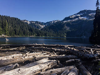 copper 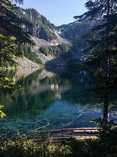 little heart 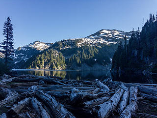 big heart  delta, trout 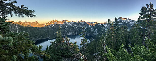 ridge camp views 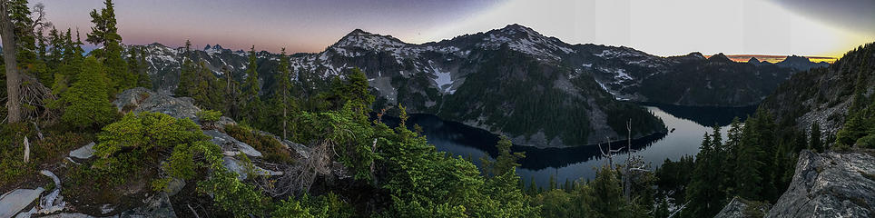 ridge camp views 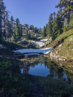 between ridge camp and 5300' tarn 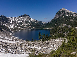 chetwoot 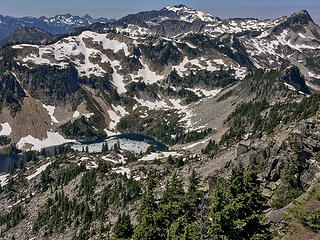 crawford, big snow, wild goat 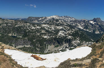 naptime 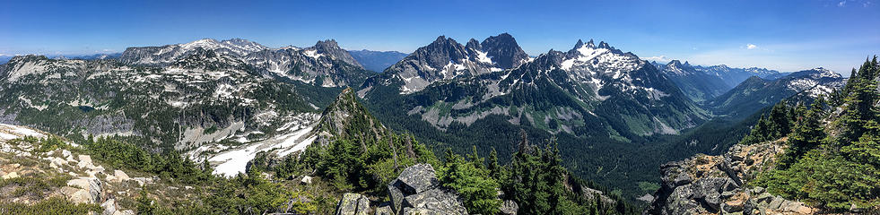 E/S summit pano 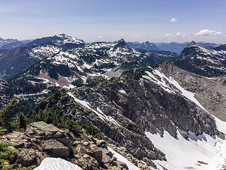 down the ridge to wild goat  iron cap lake + mtn 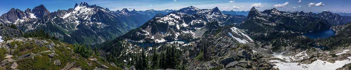 pt 6077 pano 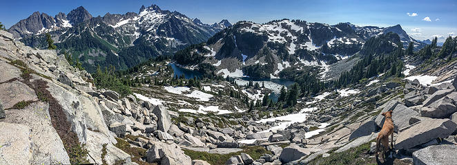 south side of the ridge 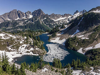 crawford 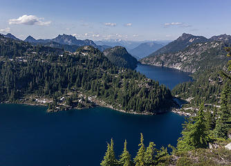 chetwoot, little c, angeline 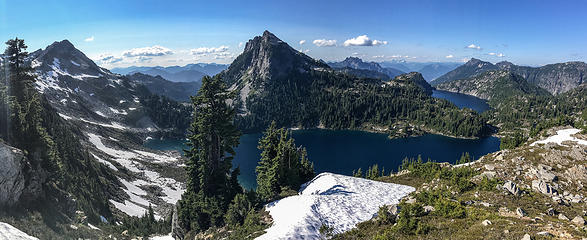 wild goat, tourmaline, lakes 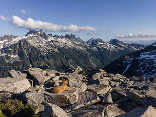 turnaround point 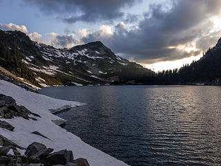 looking back 
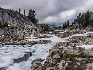 5300' tarn 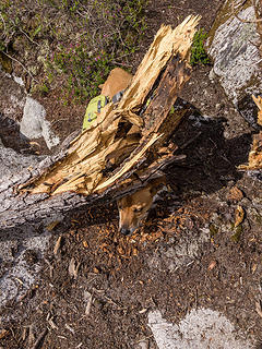 impass 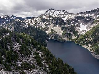 big heart and camp robber from atrium
|
| Back to top |
  
|
|
HermitThrush
Member
Joined: 14 Jan 2016
Posts: 384 | TRs | Pics
Location: Brainerd Lakes Area, MN |
Appreciate the beta. Great report. Which tarn were you at?
|
| Back to top |
|
|
Backpacker Joe
Blind Hiker

Joined: 16 Dec 2001
Posts: 23956 | TRs | Pics
Location: Cle Elum |
Yes thank you. Some really wonderful pictures you have there. 
"If destruction be our lot we must ourselves be its author and finisher. As a nation of freemen we must live through all time or die by suicide."
Abraham Lincoln
"If destruction be our lot we must ourselves be its author and finisher. As a nation of freemen we must live through all time or die by suicide."
Abraham Lincoln
|
| Back to top |
|
|
awilsondc
Member

Joined: 03 Apr 2016
Posts: 1324 | TRs | Pics
|
|
| Back to top |
|
|
mbravenboer
Member

Joined: 20 Oct 2013
Posts: 1422 | TRs | Pics
Location: Seattle |
That's an exceptional report! Great views of the conditions in that area also (particularly on Flickr).
|
| Back to top |
|
|
rubywrangler
Member
Joined: 04 Aug 2015
Posts: 511 | TRs | Pics
|
HermitThrush - the tarn is just east of Tourmaline peak, a couple hundred feet above Chetwoot lake.
I'm glad folks are enjoying the photos, it certainly is a stunning and photogenic location! I experimented with shooting in RAW on my iphone on this trip but still think the jpg panos came out better. Or maybe that spot is just more suited to panos because the views are so expansive.
|
| Back to top |
|
|
puzzlr
Mid Fork Rocks

Joined: 13 Feb 2007
Posts: 7220 | TRs | Pics
Location: Stuck in the middle |
|
puzzlr
Mid Fork Rocks
|
 Thu Jul 20, 2017 12:18 am |
|
|
I love the reminder of how scenic this area is. Great photos and just the right amount of clouds to add drama. With a newer iPhone and good lighting there's no need to apologize for the quality -- yours are some of the best I've seen.
|
| Back to top |
|
|
GaliWalker
Have camera will use

Joined: 10 Dec 2007
Posts: 4931 | TRs | Pics
Location: Pittsburgh |
|
GaliWalker
Have camera will use
|
Thu Jul 20, 2017 5:24 am |
|
|
Those are some fantastic pictures, especially for an iPhone.  That's a sublime part of the ALW. I'm missing it quite a bit right now, so thanks for the stoke.
|
| Back to top |
|
|
geyer
Member

Joined: 23 May 2017
Posts: 463 | TRs | Pics
Location: Seattle |
|
geyer
Member
|
Thu Jul 20, 2017 7:04 am |
|
|
Wow this just makes me want to hike an Alpine Lakes High Route even more! But I might have to do it in weekend sections because of time. :/ Great pics in an amazing area!
|
| Back to top |
|
|
thename
Member
Joined: 26 Jul 2015
Posts: 33 | TRs | Pics
|
|
thename
Member
|
Thu Jul 20, 2017 1:27 pm |
|
|
Great pictures!
That little tarn is one of my favorite camps in the area, glad you found the route.
|
| Back to top |
|
|
Distel32
Member
Joined: 03 Jun 2014
Posts: 961 | TRs | Pics
Location: Edmonds, WA |
|
Distel32
Member
|
Fri Jul 21, 2017 8:32 am |
|
|
|
| Back to top |
|
|
nickmtn
Member
Joined: 04 Jun 2014
Posts: 105 | TRs | Pics
Location: Kirkland, wa |
|
nickmtn
Member
|
Mon Sep 10, 2018 11:22 am |
|
|
Do you remember if there was a place to pitch a tent on the summit of Iron Cap? Any water near the summit?
|
| Back to top |
|
|
rubywrangler
Member
Joined: 04 Aug 2015
Posts: 511 | TRs | Pics
|
I think you could probably put a tent up there, but not 100% sure. The summit is pretty flat and there are a couple of clear spots, IIRC. Probably no water after the lakes.
|
| Back to top |
|
|
Tom
Admin
Joined: 15 Dec 2001
Posts: 17857 | TRs | Pics
|
|
Tom
Admin
|
Mon Sep 10, 2018 12:17 pm |
|
|
I remember it being pretty windy up there and a lot of scrub. Not an ideal place to camp.
|
| Back to top |
|
|
nickmtn
Member
Joined: 04 Jun 2014
Posts: 105 | TRs | Pics
Location: Kirkland, wa |
|
nickmtn
Member
|
Tue Sep 11, 2018 7:45 am |
|
|
Thanks for the info! Probably make my camp at those chetwood tarns 😀
|
| Back to top |
|
|
|
|


