Forum Index > Trip Reports > Washington Top 100 Peaks Updated List, July 2023
 Reply to topic
Previous :: Next Topic
Author Message
Eric Gilbertson
Member
Member


Joined: 04 Jul 2018
Posts: 188 | TRs | Pics
Location: Seattle
Eric Gilbertson
Member
PostSun Jul 23, 2023 11:58 am 
Washington Top 100 Peaks Updated List Eric Gilbertson 2017 – 2023 Summary of results: Added Peaks – Big Kangaroo, East Fury, Solitude, Chalangin, Blackcap Removed Peaks – Sherman, Luna, Castle, Switchback, Flora Order changed based on updated elevations Peaks with multiple summits: Sherpa – West summit true summit, 2ft taller than balanced rock Buckner – SW summit true summit, 1.6ft taller than NE summit Buck – Middle summit true summit, 30ft taller than north summit Cardinal – South summit true summit, 0.6ft taller than north summit Enchantment – NE summit true summit, 6-7ft taller than SW summit Greenwood – South summit true summit, 3.8ft taller than North summit Copper – North summit true summit, 1.8ft taller than south summit Big Craggy – Unclear whether East or West summit is true highpoint, 417ft apart within 0.1ft height based on Lidar, unsurveyed Link to updated WA Top 100 list in google doc form (full list also in results section of report): https://docs.google.com/spreadsheets/d/1gYaBTa32bLfXiQFrcpTJ58KjO1HIAEEMBDrttHFxUOg/edit?usp=sharing
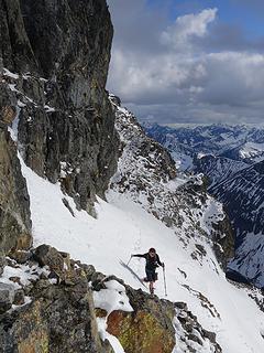
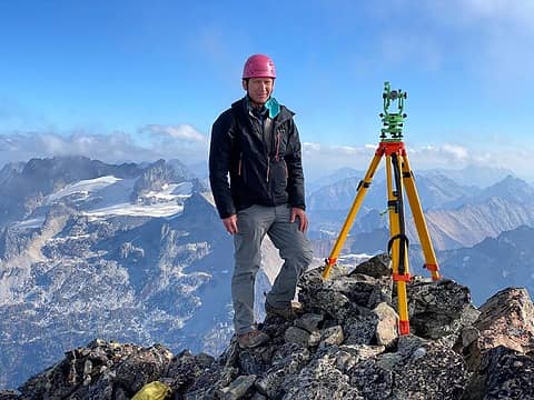
Surveying Mt Buckner with the theodolite, Oct 2022. Photo by Steven
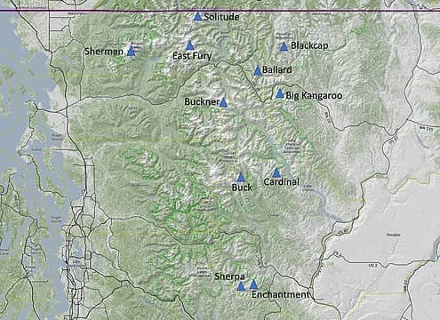
Map of the locations of ground surveys conducted
Introduction Climbing the hundred highest peaks in Washington is a popular peakbagging objective, involving glacier travel, rock climbing, bushwhacking, and general adventure. The list of the hundred highest peaks was first compiled by a group of climbers calling themselves the Bulgers in 1976 after the final of the 1:24,000 quads became available. Quadrangles (called quads for short) are topographic maps put out by the US Geological Survey (USGS). By 1976 all peaks were covered by the quads. The Bulgers generally chose the hundred highest list to include the hundred highest peaks with at least 400ft of prominence as determined by the quads. Prominence is a measure of how high a mountain rises above a saddle connecting it to a higher peak. Defining a prominence cutoff ensures minor bumps along a ridge don’t count as separate peaks. A peak must stick out enough on its own to be considered. According to John Lixvar, the 400ft prominence rule was chosen because “The distinction looks right in the field and can be clearly determined from maps with 40, 80 and 100 foot contour intervals.” There were a few exceptions to the 400ft rule, though. Seven named summits with less than 400ft of prominence based on the quads were included (Seven Fingered Jack, Sahale, Dark, Rahm, Horseshoe, Little Annapurna, and Blackcap). Volcanic subpeaks were required to have 800ft of prominence to be included. According to John Lixvar, the 800ft prominence rule was expressly formulated to not treat Liberty Cap (prominence 472ft) and Columbia Crest (the summit of Rainier) as separate mountains, but to still include Little Tahoma (prominence 818ft). This had the unintended consequence of eliminating Lincoln, Colfax, and Sherman peaks from the Bulgers list, despite each having at least 400ft of prominence based on the quads. The 800ft threshold was chosen because it is the only number greater than 472 (Liberty Cap prominence) and less than 818 (the prominence of Little Tahoma) that has 100, 40, and 80 as common denominators. The numbers 40 and 80 need to be common denominators so prominence can be accurately determined from 7.5 minute and 15 minute series quads without interpolation. 100 must be included so prominence can be determined from maps with 100 ft contours.
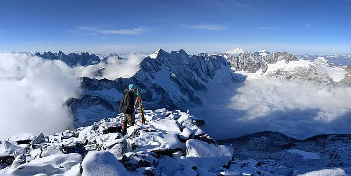
Surveying East Fury, Oct 2022. Photo by Nick
This list of peaks is generally referred to as the Bulgers or the Bulgers list or the Bulgers Top 100 list and is the most common list peakbaggers use to work on the Washington hundred highest peaks. But a second way to climb the Washington hundred highest peaks is to use a more rigorous definition including only the top 100 peaks with at least 400ft of prominence. This is referred to as the Washington Top 100 list. This list is not as popular because it includes Lincoln Peak, generally considered one of the most difficult peaks in Washington. But both lists are recognized by the Bulgers committee, and completers of either list are recognized at the annual Bulgers party. As of 2023 there have been 87 climbers to complete the Bulgers List and 20 climbers to complete the Washington Top 100 list. The Bulgers List stays constant and unchanged for historical reasons. However, the Washington Top 100 list should be updated if more accurate surveys are done. This is how it will maintain its status as the true accurate list of the 100 highest peaks in Washington with at least 400ft of prominence.
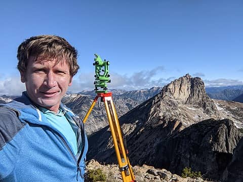
Surveying Big Kangaroo from Wallaby, June 2023
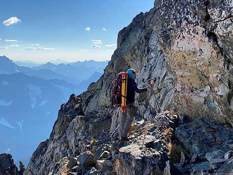
Carrying the survey equipment up Buckner, Oct 2022 (photo by Steven)
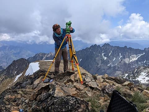
Surveying Cardinal Peak, June 2023 (photo by Nick)
In 2018 I finished climbing the Bulger List of peaks (completer number 70), and in 2019 I finished what was then considered the Washington Top 100 list (completer number 17), finishing on Lincoln Peak. I then moved on to other peakbagging objectives. But in the fall of 2022 I started looking into one of the Bulger peaks with some controversy surrounding it. Buckner Mountain has two summits, an easier SW summit that is third class and a harder 4th class NE summit. They are very similar in height, so close that it’s not really possible to tell by eye which is taller. Most climbers stop at the SW summit since it’s the first one reached on the normal ascent route. John Roper was convinced it hadn’t been surveyed accurately enough to know for sure which was the true highpoint. I brought a little handheld 5x sight level up and determined it was too close to call based on that device’s accuracy. I really wanted to settle the controversy, so I bought a mechanical theodolite and taught myself how to use it. In October 2022 I brought the theodolite and a tripod up and did a careful survey to determine that the SW summit is 1.6ft taller than the NE summit. This got me thinking that there might be other controversial peaks on the Washington Top 100 list. The quad only has 40ft contour intervals, which is not accurate enough to capture a difference of 1.6ft between two contender summits of the same peak. Also, not every peak was directly surveyed on the quad. If the peak has an elevation written on the quad, then it was surveyed directly by a surveyor pointing a theodolite at it. But peaks without the elevation written only have approximate elevations above the nearest 40ft contour line. If they were close to having enough height or prominence for list inclusion but had just never been surveyed, then perhaps they were actually Washington Top 100 peaks but nobody knew it. I now had the equipment to survey just like the original surveyors, so I could theoretically figure out if the existing Washington Top 100 list was accurate. If it wasn’t, I could update it to be as accurate as possible.
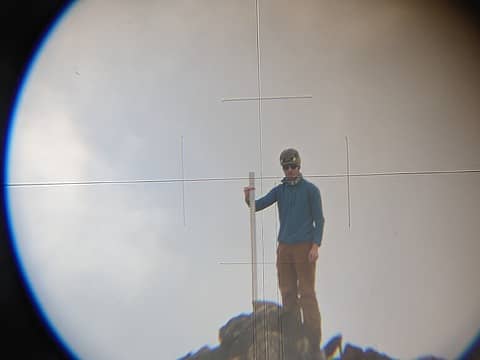
Nick holding the meter stick on the south summit of Cardinal while I sighted with the theodolite, June 2023
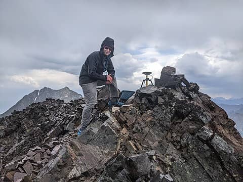
On the summit of Blackcap Mountain with the differential GPS unit, July 2023
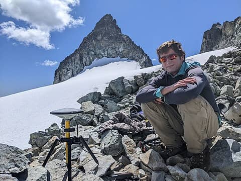
Measuring the key col elevation for Solitude Peak with the differential GPS unit, June 2023
Methodology My goal was to thoroughly and accurately determine the true hundred highest peaks in Washington with at least 400ft of prominence: the Washington Top 100 list. I first compiled a list of all peaks that were within the error bounds of the quads for list inclusion. The current lowest peak on the list was Castle Peak with a surveyed elevation of 8,306ft. This was between the 8,280ft and 8,320ft contours on the quads. But there were a handful of other peaks between these two contours that hadn’t been surveyed directly but had at least 400ft of prominence. Any of these peaks could potentially be higher than 8,306 ft and thus would qualify for the list. Greg Slayden on Peakbagger has listed all the “unranked” peaks that are close to Washington Top 100 status based on height or prominence. These edge case peaks for elevation were East Fury, West Fury, Big Kangaroo, Booker, and Wy’East. Ballard was also an edge case but was included on the Washington Top 100 list based on an estimated elevation that I wanted to check more rigorously. Another set of edge case peaks were those above 8,306ft with prominence close to but just below 400ft. To determine prominence you need to take the difference in height between the summit and the key col, which is the saddle connecting the peak to a higher peak. The key col is rarely surveyed on the quad, so to be conservative peakbaggers generally use the contour above the saddle as the elevation. This gives what is called “clean prominence”. If neither the saddle nor the summit were directly surveyed, there could theoretically be up to 40ft of error on the summit and 40ft of error on the saddle elevation, assuming the contours are drawn accurately. So any peak above 8,306ft with prominence between 320ft-399ft could potentially actually have at least 400ft of prominence. Because the clean prominence uses the upper bound contour for saddle height and lower bound contour for summit height, by definition it should always be an underestimate for prominence (assuming the contours are accurate, which is generally true). Thus, peaks with over 400ft of clean prominence based on the quad are very unlikely to actually have less than 400ft of prominence. But contours and even surveyed summit elevations can sometimes have a few feet of error, so I wanted to double check cases between 400ft-410ft of prominence also. The list of edge cases for the prominence criteria were thus Pinnacle North, Blackcap, Solitude, Seven Fingered Jack, Changalin, Sherman, Sherpa, and Colfax.
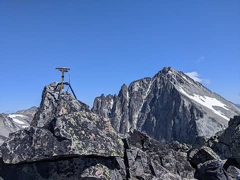
The differential GPS unit on the summit of Solitude Peak, June 2023
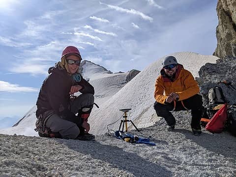
Measuring the key col elevation for Sherman Peak with Kahler, July 2023
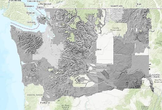
Current Lidar coverage in Washington (source: WA Lidar portal)
My plan was to analyze and measure each of these edge cases first at home using Lidar and photo analysis if possible, and then by conducting ground surveys in the field if necessary. For any ground surveys I would only report results if I got at least two independent consistent measurements (ie surveyed from two different points with the theodolite giving same result, or same result from theodolite and photo analysis and GPS analysis). To make the project as thorough as possible I planned to update the elevations of all peaks on the Washington Top 100 list that had been surveyed by Lidar, not just the edge case peaks. I converted all elevations to the same NGVD29 datum to be consistent with the quads. A datum is basically a definition of sea level or a zero-elevation reference that all peaks are measured relative to. There has recently been an updated datum (NAVD88), but to be consistent with surveyed elevations on the quads I’ve converted all elevations to NGVD29 using orthometric height. This is also consistent with all elevations for these peaks listed on peakbagger.com. Lidar coverage over Washington is incomplete and it is unclear when or if the entire state will be covered. So, I reported each peak elevation either from Lidar, from a direct survey on the quad, from an estimated elevation from the quad to the nearest lower contour, or from my own ground survey. The end result is an updated version of the Washington Top 100 list with the most accurate updated elevation for each peak. Eight peaks on the current Washington Top 100 list were in a situation similar to Buckner where there were multiple summits of similar height and nobody had done an accurate enough survey to determine which was the true highpoint. Peakbaggers need to climb the true highpoint of each peak to complete the Washington Top 100 list, so I used my surveying tools to measure these peaks as well. This would ensure the Washington Top 100 list was as accurate as possible.
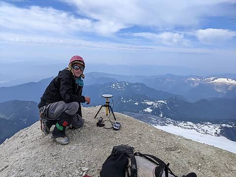
Measuring the summit of Sherman Peak, July 2023
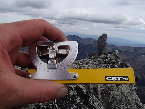
Measuring the relative height of Sherpa Balanced Rock, August 2017
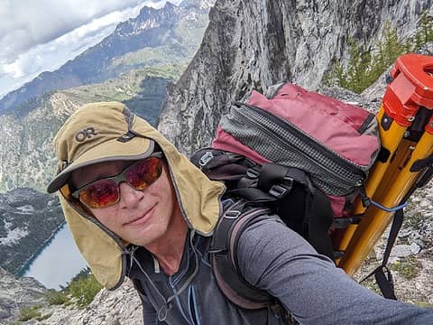
Hiking up to Enchantment Peak with the theodolite and tripod, June 2023
Equipment Over the course of this project I acquired and learned how to use a variety of surveying tools, both software and hardware: 1. Lidar – Lidar (Light Detection and Ranging) is a way to measure elevations very accurately from a plane. The plane flies over the ground and emits pulsed light waves that bounce off the ground and return to the plane. By measuring the time it takes the pulse to return you can find the distance between the plane and the ground. If the plane’s position is known very accurately using GPS then this can be used to find the absolute elevation of points on the ground. The USGS has a goal of getting full Lidar coverage of the entire US by the end of 2023. In the lower 48 states the goal is to get 10cm (4 inch) vertical accuracy with data taken at 1m intervals (3.3ft). In practice the errors can be a bit higher than 4 inches for measured points in mountainous terrain, and the terrain between measured points is unsampled with unknown elevation. Sometimes data points are missed and spacing isn’t always consistent, so points can be up to 6ft or more apart in practice, I’ve found. If a summit is very sharp it’s possible the very top is not sampled directly, and thus Lidar can give an underestimate of a summit by up to a few feet. This can make a difference for peaks with multiple summits of very similar height, or for peaks of similar height near the bottom of the Washington Top 100 list. To access Lidar data for Washington I used the Washington Lidar Portal (https://lidarportal.dnr.wa.gov/). Data is given in the form of point clouds and Digital Elevation Models (DEMs). The point cloud is the raw data, given as an elevation for each sampled point. The DEM is a continuous model that approximates the elevations between the sampled points. For my analysis I used the raw point cloud data, since this doesn’t introduce any elevation approximations for unsampled regions. To analyze point cloud data I used QGIS (https://qgis.org/en/site/), an open-source software package. For a given peak I uploaded the most recent Lidar survey from the WA Lidar Portal into QGIS, then color coded the points by elevation. I zoomed in to find the highest sampled point, which was the summit elevation. To find the key col I used Peakbagger to find the coordinates of the approximate key col location. Then I zoomed in on the point cloud to find the lowest point on the ridge. This gave the key col elevation. The Lidar data is all given using the NAVD88 datum. To convert to NGVD29 datum I used NCAT (National Geodetic Survey Coordinate Convertsion and Transformation Tool, https://www.ngs.noaa.gov/NCAT/). Lidar coverage has recently been completed for all of the mountains of Colorado and Wyoming in 2022, and people have analyzed this data to update the Colorado hundred highest list (the Centennials, adding Arrow and Trinity and removing Dallas and Teakettle), and the Wyoming 13ers list (adding one peak, Miriam Peak). Lidar coverage is not currently complete in Washington, and large portions of the North Cascades and Pasayten are not currently covered. These areas happen to contain some of the most remote peaks in the lower 48 states, and perhaps this means the areas are lower priority for coverage. 2. Photo Analysis – Edward Earl has written a software program that can determine relative elevations of peaks from a photo. How it works is you use a picture taken from a summit of known height looking towards a summit of unknown height. You identify peaks in the background with known height and enter their heights, lat/lon coordinates, and pixel locations in the photo. You also enter the height of the camera and lat/lon of the camera and of the unknown summit. The software uses this information along with corrections for lens distortion and atmospheric effects to give an estimate of the relative height of the unknown peak to the elevation of the camera. Error bounds are given based on the information input for the background peaks. This software has been used on Buckner Mountain’s SW and NE peaks and got a height difference consistent with Lidar and with my theodolite measurements. The software is not currently posted online but can be provided on request.
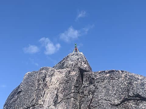
The theodolite mounted on the summit of Enchantment Peak NE summit, June 2023
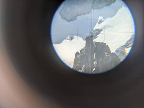
Sighting the SW summit of Enchantment peak from the NE summit with the theodolite, June 2023
3. SRTM (Shuttle Radar Topography Mission) – In 2000 a special radar system was flown on a satellite and took elevation measurements of most of the earth. The method is similar to Lidar – if the satellite’s position is known accurately and the time is recorded for a signal to be sent to the earth’s surface and bounce back, then the elevation of the sampled point can be determined. This data was taken at 30m (100ft) sampling intervals for most places, and in genera has vertical errors up to 50ft (source: https://www2.jpl.nasa.gov/srtm/statistics.html). This data can be found online using google earth (earth.google.com). This can be a useful tool in areas where no other data is available, but is generally not accurate enough for this project in Washington where peak elevations need to be known to the nearest foot or less. 4. USGS Quads – These maps cover all peaks in Washington with an accuracy determined by 40ft contours and many peaks directly surveyed. They are easily available on peakbagger.com. 5. Sight level – This is the most basic tool for use in ground surveys. It is a small mechanical device between 6in – 1ft long with a bubble level inside that can be rotated. The bubble level is connected to an angular vernier scale so angular inclination and declination measurements can be taken. I own a 1x magnification CST Berger sight level and a 5x Sokkia sight level, each with 10 arcminute accuracy on vernier scales. These are useful for measuring relative elevations. If I lay down on a summit of known surveyed height and measure the angular inclination or declination to a summit of unknown height, and I find the distance between them from Google earth or caltopo or another source, I can use trigonometry to find the relative height. If I add the relative height to the absolute height of the first mountain I find the absolute height of the other mountain. 6. Theodolite – This is a device that also measures relative angles between points, like sight levels. However, it is much more accurate. It is mounted on a tripod and very fine angular adjustments can be made. The original USGS surveyors used theodolites to make the quads. I own a 20 arcseond, 30x magnification mechanical theodolite. Electronic theodolites exist and are a standard tool for surveyors nowadays, but they are expensive. Mechanical theodolites are still commonly used in India and I was able to buy a cheap new model on ebay. I taught myself how to use it with instructional videos for civil engineers online.
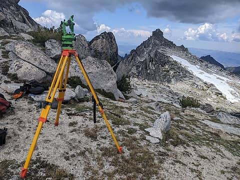
Taking a measurement from the saddle to the summit of Enchantment Peak NE, June 2023
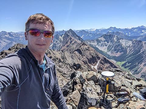
Measuring Mt Ballard with the differential GPS unit, July 2023
7. Handheld GPS – I have a Garmin 62S handheld GPS unit that can be useful for gaining confidence in results, but is not accurate enough by itself to be definitive in a final height. Typical errors can be 20-30ft vertical, but this device is much more accurate than a phone GPS or watch GPS. 8. Phone GPS – The GPS in a phone or watch is generally less accurate than the Garmin 62S and is not really useful for this survey project. Pressure-based altitude readings can have high errors influenced by weather (ie a low-pressure storm moving in would make the measured altitude be higher since the pressure is lower). 9. Survey-grade differential GPS unit – This is the most accurate GPS unit and can give measurements accurate to within 1 inch error in vertical absolute elevation. I have been loaned a Spectra Promark 220 with Ashtech antenna from the Seattle University Civil Engineering department. I’d used this kind of unit before, borrowed from Compass Data, for discovering/surveying the country highpoints of Saudi Arabia, Togo, Gambia, Guinea, Guinea-Bissau, and Ivory Coast. The unit I have now has a big antenna to account for multipath errors and a rover unit that looks like a large handheld GPS. How it works is I mount the antenna on a tripod so a pole below the antenna touches the point I want to survey. The antenna is connected to the rover unit with a cable and I start taking measurements. This unit is GNSS (Global Navigation Satellite System), meaning it has access to many more satellites than a standard handheld GPS (Global Positioning System) unit. This helps increase accuracy. The longer I take measurements the more accurate the result. It’s called a differential GPS because I compare the measurements taken by the rover unit to those taken by nearby base stations. Base stations are locations where a GNSS unit has sat stationary for years, so its position is known with very high accuracy. If I compare my measurements to those of nearby base stations I can correct for atmospheric distortions which affect accuracy. This assumes the atmospheric conditions at the base stations are similar to those where I take the measurement. This means I need to post process my measurements afterwards, and I need to wait for enough data to be collected by the base stations to do the post processing. The US National Oceanic and Atmospheric Administration (NOAA) has an online tool to post process measurements taken in the US (https://geodesy.noaa.gov/OPUS/). You just need to wait 24-36 hours after they were taken, then convert them to the correct format (RINEX), upload them and you get results within a few minutes with 1-sigma error bounds. The rule of thumb is in an area with a clear view of the sky you can get about 3 inch vertical accuracy with 20 minutes of data and 1 inch vertical accuracy after an hour of taking measurements. I’ve talked to surveyor engineers from Compass Data (the company who surveyed Denali) and they say the surveying standard is a one-hour measurement. That’s what I did surveying in West Africa and I got good results. In general I took one-hour measurements surveying peaks in Washington also.
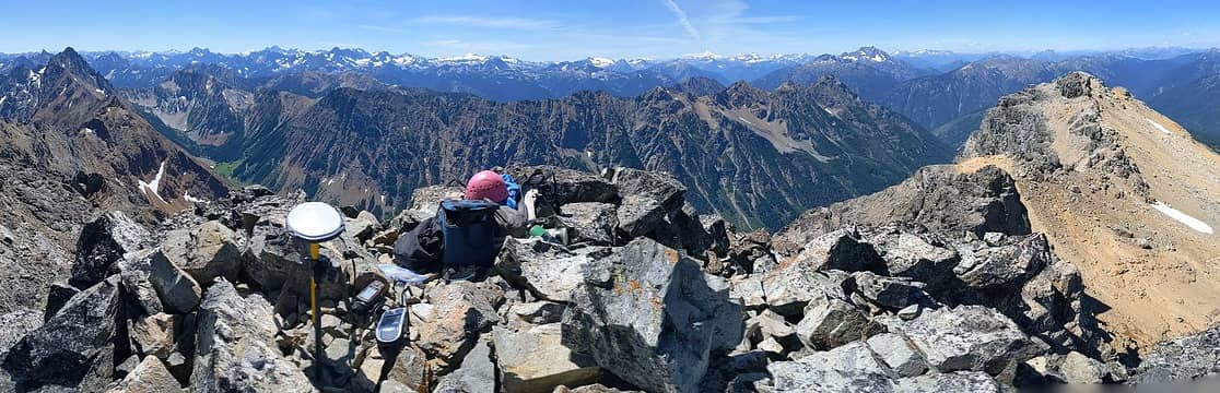
On the summit of Mt Ballard, July 2023
Results After analyzing all of the peaks with existing Lidar coverage and those where photo analysis was possible I started conducting ground surveys. This involved climbing the peaks or saddles or nearby peaks and using sight levels, the theodolite, and the GPS units to take measurements. Note: detailed reports and raw measurement data can be found in linked reports for each peak in the final table below. I found that five peaks need to be added to the Washington Top 100 list. These are Big Kangaroo, East Fury, Solitude, Chalangin, and Blackcap. In the cases of East Fury and Big Kangaroo the summits were not directly surveyed on the quad and, in fact, the quads were missing two contour lines for each peak. This can happen if the summits are very sharp, as in the case of Big Kangaroo, and if the peak is very remote in a sparsely-surveyed area, as for East Fury located deep in the Picket Range of the North Cascades. I surveyed these peaks by using my theodolite placed on nearby surveyed peaks and measuring relative heights.
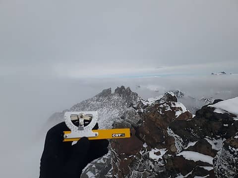
Surveying Buck Mountain, June 2021
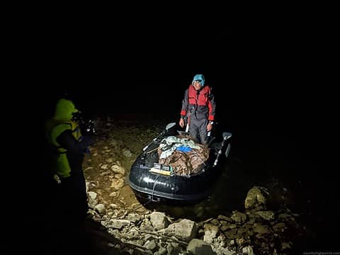
Taking the survey equipment up Ross Lake in my zodiac boat en route to surveying East Fury, Oct 2022 (photo by Nick)
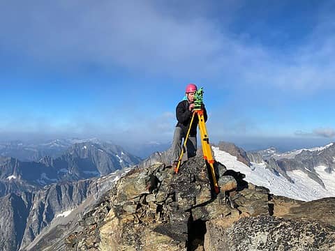
Taking measurements on Buckner Mountain, Oct 2022 (photo by Steven)
I found that Solitude, Chalangin, and Blackcap all had more prominence than shown on the quad. Chalangin was covered by Lidar, so its prominence was easy to determine from the point cloud data. Solitude and Blackcap were not covered by Lidar. In these cases I needed to measure both the summit and key col elevations. For these peaks I climbed to each summit and key col and used the Spectra Promark 220 differential GPS unit to get very accurate elevations. Because five peaks got added, this means five peaks needed to be removed from the final list. The peaks that got removed were Sherman, Luna, Castle, Switchback, and Flora. I used Lidar analysis to determine Switchback and Flora were too short for list inclusion. Luna and Castle had direct surveyed elevations on the quads and were also too short. I conducted a ground survey with the Spectra Promark 220 to determine that Sherman Peak in fact doesn’t have enough prominence for list inclusion. There were eight peaks on the WA Top 100 list that had multiple summits of similar height and it was not previously known with certainty which was the true summit. These peaks were Sherpa, Buckner, Buck, Cardinal, Enchantment, Copper, Greenwood, and Big Craggy. In these cases I first analyzed Lidar data, which happened to exist for each of these peaks. If Lidar data showed the peak elevations within error bounds of Lidar, then I conducted a ground survey with either a sight level or the theodolite. In some cases I was able to take measurements with a partner. The partner held a meter stick on one summit, and I leveled the theodolite from the other summit and saw where the scope cross hairs hit the meter stick. We would coordinate using radios. I used this method on Buckner and Cardinal. Interestingly, I found the south summit of Cardinal is 7 inches taller than the middle summit. This is a significant finding because peakbaggers have traditionally just climbed the middle summit, which is third class. The south summit is a 5th class spire 600ft to the south and considerably more difficult. For Enchantment and Sherpa peaks I took angular measurements from the easier summit sighting the more challenging summit and used these to calculate relative heights. In these cases it would have been very challenging for a partner to stand holding a meter stick on the more difficult summit. For Big Craggy the Lidar data has the East and West summits within two inches of height, and this is within the error bounds of Lidar. I have not yet conducted a ground survey of these peaks, so it is not known for sure which is taller. But they are each class 2 separated by 417ft along an easy ridge, so it is not difficult for peakbaggers to tag both. This is much different than Cardinal and Sherpa, where one peak is significantly more difficult than the other.
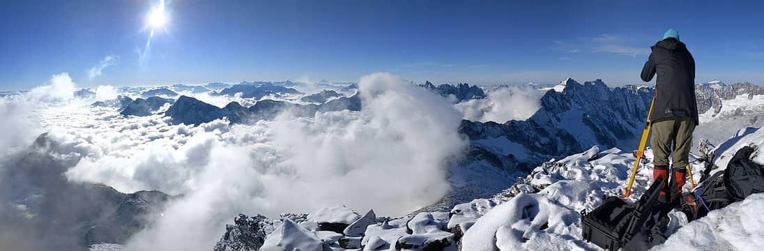
Measuring East Fury with the theodolite, Oct 2022 (photo by Nick)
Below is the full table of updated Washington Top 100 list, including links to trip reports for peaks where ground surveys were conducted: [Note – prominence data is only given for peaks that I directly measured the prominence with ground surveys or from Lidar. ] Link to list in google doc form: https://docs.google.com/spreadsheets/d/1gYaBTa32bLfXiQFrcpTJ58KjO1HIAEEMBDrttHFxUOg/edit?usp=sharing Rank Peak Elevation Prom Notes 1 Mount Rainier 14,411 No Lidar point cloud data, surveyed elevation from quad used 2 Liberty Cap 14,112 No Lidar point cloud data, surveyed elevation from used 3 Mount Adams 12,273 Lidar elevation converted to NGVD29 using NCAT 4 Little Tahoma 11,138 No Lidar point cloud data, surveyed elevation from quad used 5 Mount Baker 10,773 Lidar elevation converted to NGVD29 using NCAT 6 Glacier Peak 10,597 Lidar update of summit to NGVD29 using NCAT 7 Bonanza Peak 9,503 Lidar elevation converted to NGVD29 using NCAT 8 Colfax Peak 9,441 442 Lidar elevation converted to NAVD29 using NCAT. Prominence found from Lidar 9 Mount Stuart 9,414 Lidar elevation converted to NGVD29 using NCAT 10 Mount Fernow 9,241 Lidar elevation converted to NGVD29 using NCAT 11 Goode Mountain 9,223 Lidar elevation converted to NGVD29 using NCAT 12 Mount Shuksan 9,125 Lidar elevation converted to NGVD29 using NCAT 13 Mount Buckner 9,111 Lidar elevation converted to NGVD29 using NCAT. SW summit measured 1.6 ft taller than NE with theodolite survey 14 Mount Logan 9.087 No lidar coverage, surveyed point on quad 15 Mount Maude 9,080 Lidar elevation converted to NGVD29 using NCAT 16 Lincoln Peak 9,096 Lidar elevation converted to NGVD29 using NCAT 17 Jack Mountain 9,066 No lidar coverage, surveyed point on quad 18 Black Peak 8,986 Lidar elevation converted to NGVD29 using NCAT 19 Mount Spickard 8,979 No lidar coverage, surveyed point on quad 20 Mount Redoubt 8,969 No lidar coverage, surveyed point on quad 21 Copper Peak 8,959 Lidar elevation converted to NGVD29 using NCAT. North summit 1.8ft taller than south based on Lidar 22 North Gardner 8,956 No lidar coverage, surveyed point on quad 23 Dome Peak 8,921 Lidar elevation converted to NGVD29 using NCAT 24 Gardner Mtn 8,897 Lidar elevation converted to NGVD29 using NCAT 25 Boston Peak 8,883 Lidar elevation converted to NGVD29 using NCAT 26 Silver Star Mtn 8876 No lidar coverage, surveyed point on quad 27 Eldorado Peak 8868 No lidar coverage, surveyed point on quad 28 Dragontail Peak 8836 Lidar elevation converted to NGVD29 using NCAT 29 Forbidden Peak 8815 No Lidar coverage, surveyed point on quad 30 Oval Peak 8795 Lidar elevation converted to NGVD29 using NCAT 31 Mesahchie Peak 8795 No lidar coverage, surveyed point on quad 32 Mount Lago 8745 No lidar coverage, surveyed point on quad 33 Robinson Mtn 8726 No lidar coverage, surveyed point on quad 34 Colchuck Peak 8706 Lidar elevation converted to NGVD29 using NCAT 35 Star Peak 8688 Lidar elevation converted to NGVD29 using NCAT 36 Remmel Mtn 8685 No lidar coverage, surveyed point on quad 37 Katsuk Peak 8680 No Lidar coverage, not surveyed, need ground survey 38 Fortress Mtn 8679 Lidar elevation to NGVD29 using NCAT 39 Cannon Mtn 8652 Lidar elevation converted to NAVD29 using NCAT 40 Sherpa Peak 8630 432 Lidar update of summit NGVD29, prominence. Sight level survey showed W summit 1-2ft taller than balanced rock. Lidar shows W summit 2ft taller. Prominence found from Lidar. 41 Mount Custer 8630 No lidar coverage, surveyed point on quad 42 Ptarmigan Peak 8614 No lidar coverage, surveyed point on quad 43 Cathedral Peak 8601 No lidar coverage, surveyed point on quad 44 Kimtah Peak 8600 No Lidar coverage, summit not surveyed, need ground survey 45 Mount Carru 8595 No Lidar, surveyed point on quad 46 Monument Peak 8592 No Lidar, surveyed point on quad 47 Raven Ridge 8592 Lidar elevation converted to NGVD29 using NCAT 48 Cardinal Peak 8591 Lidar elevation converted to NGVD29 using NCAT. South summit measured 7 inches taller than middle with theodolite survey 49 Osceola Peak 8587 No Lidar, surveyed point on quad 50 Clark Mountain 8582 Lidar elevation converted to NGVD29 using NCAT 51 Storm King 8559 Lidar elevation converted to NGVD29 using NCAT 52 Enchantment Pk 8538 Lidar elevation converted to NGVD29 using NCAT. NE summit 6-7ft taller than SW based on theodolite survey 53 Buck Mountain 8534 Lidar elevation converted to NGVD29 using NCAT 54 Cashmere Mtn 8514 Lidar elevation converted to NGVD29 using NCAT 55 Reynolds Peak 8512 Lidar elevation converted to NGVD29 using NCAT 56 Primus Peak 8508 No lidar coverage, surveyed point on quad 57 Martin Pk Holden8504 Lidar elevation converted to NGVD29 using NCAT 58 Hard Mox 8504 No lidar coverage, surveyed point on quad 59 Klawatti Peak 8485 No lidar coverage, surveyed point on quad 60 Big Craggy Peak 8473 Lidar elevation converted to NGVD29 using NCAT. Unsurveyed whether east or west summit is highpoint. 417ft horizontal apart, within 2 inches height on Lidar 61 Hoodoo Peak 8470 Lidar elevation converted to NGVD29 using NCAT 62 Mount Bigelow 8468 Lidar elevation converted to NGVD29 using NCAT 63 Lost Peak 8464 No lidar coverage, surveyed point on quad 64 Argonaut Peak 8455 Lidar elevation converted to NGVD29 using NCAT 65 Chiwawa Mtn 8453 Lidar elevation converted to NGVD29 using NCAT 66 Luahna Peak 8445 Lidar elevation converted to NGVD29 using NCAT 67 Tower Mountain 8444 No lidar coverage, surveyed point on quad 68 Dorado Needle 8440 No Lidar coverage, top not surveyed, need ground survey 69 Sinister Peak 8439 Lidar elevation converted to NGVD29 using NCAT 70 Azurite Peak 8434 Based on 1x sight level measurement from Ballard, with Ballard height measured With differential GPS 71 Emerald Peak 8414 Lidar elevation converted to NGVD29 using NCAT 72 Dumbell Mtn 8411 Lidar elevation converted to NGVD29 using NCAT 73 Greenwood Mtn 8408 Lidar elevation converted to NGVD29 using NCAT. South summit 3.7ft taller than north based on Lidar 74 Easy Mox 8407 No lidar, surveyed point on quad 75 Solitude Peak 8406 414 Measured elevation and prominence with spectra promark 220 dGPS and two sight levels, elevation in NGVD29 76 Blackcap Mtn 8402 406 Measured elevation and prominence with spectra promark 220 dGPS and two sight levels, elevation in NGVD29 77 Pinnacle Mtn 8399 Lidar elevation converted to NAV8D29 using NCAT 78 Saska Peak 8399 Lidar elevation converted to NGVD29 using NCAT 79 Courtney Peak 8389 Lidar elevation converted to NGVD29 using NCAT 80 Spectacle Buttes8391 Lidar elevation converted to NGVD29 using NCAT 81 Devore Peak 8378 Lidar elevation converted to NGVD29 using NCAT 82 Martin Peak 8372 Lidar elevation converted to NGVD29 using NCAT. Sawtooths Martin. 83 Mount Ballard 8371 Measured with spectra promark 220 differential GPS 84 Lake Mountain 8371 No lidar coverage, surveyed point on quad 85 Chalangin 8369 409 Lidar elevation converted to NGVD29 using NCAT. Prominence measured by Lidar 86 West Craggy 8367 Lidar elevation converted to NGVD29 using NCAT 87 Golden Horn 8366 No lidar coverage, surveyed point on quad 88 McClellan Peak 8363 Lidar elevation converted to NGVD29 using NCAT 89 Amphitheater Mtn 8358 No lidar coverage, surveyed point on quad 90 Mt Fury East Pk 8356 Theodolite survey, height measured relative to Luna surveyed height 91 Snowfield Peak 8347 No lidar coverage, surveyed point on quad 92 Tupshin Peak 8340 Lidar elevation converted to NGVD29 using NCAT 93 Austera Peak 8334 No lidar coverage, surveyed point on quad 94 Windy Peak 8333 No lidar coverage, surveyed point on quad 95 Cosho Peak 8332 No lidar coverage, surveyed point on quad 96 Big Snagtooth 8330 No lidar coverage, surveyed point on quad 97 Abernathy Peak 8327 Lidar elevation converted to NGVD29 using NCAT 98 Mt Saint Helens 8326 Lidar elevation converted to NGVD29 using NCAT 99 Big Kangaroo 8326 Theodolite survey, height measured relative to Wallaby and WA Pass surveyed points 100 Mt Formidable 8325 No lidar coverage, surveyed point on quad Flora Mountain 8323 Lidar elevation converted to NGVD29 using NCAT Switchback Mtn 8321 Lidar elevation converted to NGVD29 using NCAT Luna 8311 No lidar coverage, surveyed point on quad Castle 8306 No lidar coverage, surveyed point on quad Sherman 10,133 395 Surveyed with Spectra Promark 220 on summit and key col. Removed from WA Top 100 list since prominence <400 Discussion To the best of my knowledge this is now the most accurate list of the Washington Top 100 peaks with 400ft of prominence. It is still possible that there could be future updates to this list. One update is that the order could be slightly modified. There are three peaks that are not covered by Lidar, were not directly surveyed on the quad, and I have not yet surveyed with my theodolite or differential GPS unit. These are Dorado Needle, Kimtah, and Katsuk. The elevations given for these peaks are currently the elevation of the highest contour of the peaks on the quads. These elevations are likely slight underestimates of up to 40ft, the spacing between contours. But sometimes the errors can be higher for these unsurveyed peaks. For instance, Mt Fortress is not directly surveyed on the quad and is 80ft higher based on Lidar data than the highest contour height on the quad. And I found with a theodolite survey that East Fury is 76ft taller than the highest contour on the quad. However, none of the peaks in this situation are low enough on the list that an error of up to 80ft would bump any peak off the list or add another peak. An error like this would just rearrange the order of peaks. And I’ve analyzed or measured all of the edge-case unsurveyed peaks between the 8,280ft-8,320ft contour levels either with Lidar or ground surveys. Unsurveyed peaks between the 8,240ft-8,280ft contours (given a listed height of 8,240ft) would still be too short to qualify for the list even with 80ft error in summit elevation. Also, many peaks have been directly surveyed on the quad but have not been measured by Lidar or with a differential GPS unit. I’ve found from comparing Lidar measurements to direct survey measurements that the quad surveyed measurements can have errors up to 5ft. If Lidar measurements are taken for these peaks it could rearrange the list order, and it could also potentially add or subtract a peak near the bottom of the list. Mt Formidable is peak number 100 on the list, and is in this situation. It is directly surveyed on the quad but not measured by Lidar or by a differential GPS unit. If Mt Formidable is three feet shorter than the quad height then it would get bumped off the list and Flora added to the list. Also, for Big Kangaroo I measured its height with my theodolite relative to two surveyed points on the quad (Wallaby Peak and Washington Pass). If these surveyed points are in fact four feet or more shorter than listed on the quad then Big Kangaroo would get removed and potentially Flora and Switchback added. These two scenarios are unlikely but not impossible. One option to resolve this uncertainty is to wait for Lidar measurements to be taken for these peaks. But there is no guarantee that will happen any time soon. This uncertainty could be also resolved if I take the differential GPS unit to the summit of Mt Formidable and also to the surveyed points on Wallaby and Washington Pass. It would be practically very difficult to bring the unit to the summit of Big Kangaroo since the summit is so small and sharp that I doubt I could even balance the antenna on it. These are all areas of potential future work on the project. Acknowledgements I’d like to thank Steph S for loaning me her 1x sight level to survey Sherpa Peak in 2017. Katie Stanchak advised on methodology and equipment for the duration of the project. Nick R, Steven S, Talon J, and Kahler K helped haul survey equipment up peaks and assisted with field measurements. Greg S gave valuable information about peaks through peakbagger.com and other correspondance, helped me understand the photo analysis tool developed by Edward Earl, and advised me on sight levels. Andy M helped estimate East Fury’s height based on other photo analysis. Scramblin Rover on nwhikers first found that Chalangin has enough prominence for list inclusion. Jake O gave valuable advice on the accuracy of Lidar. Compass Data engineers first taught me how to use a differential GPS unit. Dan helped double check my results post processing data from the differential GPS unit, which was loaned to me by Seattle University. Many members of the nwhikers forum gave valuable feedback about my methods and which peaks I should survey. John R inspired me to bring a theodolite up Buckner for my first major field survey. Lily helped me take calibration measurements with the theodolite when I was learning to use it. Link to more pictures: https://www.countryhighpoints.com/washington-top-100-peaks-updated-list/

adam.rhoda1, dave allyn, Route Loser, IanB, rubywrangler, jstern, ancient_squirrel, John Mac, kw, zimmertr, MistyMountainHop, SeanSullivan86, yukon222  Josh Journey, geyer, freddyfredpants, Alden Ryno, Gimpilator, jaysway  awilsondc, Bluebird  RichP
Back to top Reply to topic Reply with quote Send private message
yukon222
Member
Member


Joined: 12 Mar 2007
Posts: 1894 | TRs | Pics
yukon222
Member
PostSun Jul 23, 2023 3:03 pm 
Spectacular work. I’ve really enjoyed reading your adventures and huge efforts to reconcile this data. 👍👍

Eric Gilbertson
Back to top Reply to topic Reply with quote Send private message
Gimpilator
infinity/21M


Joined: 12 Oct 2006
Posts: 1690 | TRs | Pics
Location: Edmonds, WA
Gimpilator
infinity/21M
PostSun Jul 23, 2023 6:21 pm 
A wonderful summary for your highly respectable project. You've changed the whole game, and many who take peakbagging seriously are going to benefit from your findings. Thank you, and also thanks to everyone who assisted in these surveys. Strong work.

Summitpost | YouTube | Peakbagger

freddyfredpants, Eric Gilbertson, Alden Ryno
Back to top Reply to topic Reply with quote Send private message
zimmertr
TJ Zimmerman


Joined: 24 Jun 2018
Posts: 1249 | TRs | Pics
Location: Issaquah
zimmertr
TJ Zimmerman
PostSun Jul 23, 2023 6:50 pm 
Fantastic work! Any idea what objective is next for you, if any?

Flickr | Strava

Eric Gilbertson
Back to top Reply to topic Reply with quote Send private message
Bluebird
suffering optional


Joined: 22 Jan 2014
Posts: 200 | TRs | Pics
Location: United States
Bluebird
suffering optional
PostSun Jul 23, 2023 7:50 pm 
This is so interesting and impressive that you went to all this effort to get the correct data. I'm curious to see what happens with those are are working on Bulgers, given that many may have climbed the incorrect summit, particularly Cardinal (having climbed the south summit can attest it is much more of a thing than the other!).

Eric Gilbertson
Back to top Reply to topic Reply with quote Send private message
Riverside Laker
Member
Member


Joined: 12 Jan 2004
Posts: 2821 | TRs | Pics
Riverside Laker
Member
PostSun Jul 23, 2023 8:09 pm 
What an interesting and fun project.

Eric Gilbertson
Back to top Reply to topic Reply with quote Send private message
Eric Gilbertson
Member
Member


Joined: 04 Jul 2018
Posts: 188 | TRs | Pics
Location: Seattle
Eric Gilbertson
Member
PostMon Jul 24, 2023 8:24 am 
Thanks!
Quote:
Any idea what objective is next for you, if any?
I'm continuing on the country highpoints project now. Hopefully Azerbaijan tomorrow then a few more in the stans. I will need to survey some candidates over here so it was great to build up skills in Washington.

Josh Journey, zimmertr, RichP
Back to top Reply to topic Reply with quote Send private message
Scramblin Rover
Member
Member


Joined: 24 Jun 2023
Posts: 32 | TRs | Pics
Location: Seattle
Scramblin Rover
Member
PostMon Jul 24, 2023 11:56 pm 
Very impressive collection of trips and nice, thorough summary of your whole project. It will be interesting to see what happens when we get lidar data for the other peaks. According to the US Interagency Elevation Inventory, they flew lidar for most of the rest of the North Cascades in 2021 and 2022 but they haven't released the data yet, so we can probably expect those gaps to be filled in the next couple of years. As you note, most of the errors in the USGS survey elevations are small, but some are larger (for instance, Sherpa, Clark, and Raven Ridge have 20-30ft errors). There are several peaks near the bottom of the list that could get bumped off if there was an error of that magnitude, and an error in the other direction could add Luna or Castle to the list. One interesting thing I noticed when looking at lidar data is that there are actually several different lidar datasets for Mt. St. Helens and the elevations range from 8322-8326 feet. At the low end, that could also knock St. Helens off the list. Most of the unsurveyed peaks that are close to qualifying for the top 100 have lidar, so I'd be surprised if the list changed that way, but there are some close calls (lidar shows that Tenpeak Mountain is 8307 feet compared to the 8200-8240' elevation on the contour map, and Kennedy Peak is 8377 feet but with only 392 feet of prominence). Good luck with your country highpoint surveying expeditions. I'm definitely looking forward to reading those reports.

Eric Gilbertson, RichP
Back to top Reply to topic Reply with quote Send private message
Josh Journey
a.k.a Josh Lewis


Joined: 01 Nov 2007
Posts: 4842 | TRs | Pics
Josh Journey
a.k.a Josh Lewis
PostWed Aug 16, 2023 1:02 am 
What an amazing accomplishment! Several P400 peaks I climbed have been bumped off removing my 98/100 score. lol.gif The good news is that this just means more great peaks to climb.
Eric Gilbertson wrote:
Mt Formidable is peak number 100 on the list, and is in this situation. It is directly surveyed on the quad but not measured by Lidar or by a differential GPS unit. If Mt Formidable is three feet shorter than the quad height then it would get bumped off the list and Flora added to the list.
This is the most interesting of Washington's unsolved mysteries. cool.gif I'm safe WA 100 wise but am very intrigued if Formidable remains. Big Craggy is another summit debate of interest (East vs West summit).
Eric Gilbertson wrote:
It would be practically very difficult to bring the unit to the summit of Big Kangaroo since the summit is so small and sharp that I doubt I could even balance the antenna on it. These are all areas of potential future work on the project.
What if the GPS had a small sling and was mounted to it to go over the summit horn? Sure it would physically be 6 inches or so lower; but a measuring tape could fix the last 6 inches of elevation loss and would be far more accurate than a 5 foot differential. We are all very grateful for this big update to the Washington Top 100. borank.gif borank.gif I recall hearing about how challenging it was to come up with the original Bulgar list. This is another evolution of a higher calling.

Eric Gilbertson
Back to top Reply to topic Reply with quote Send private message
   All times are GMT - 8 Hours
 Reply to topic
Forum Index > Trip Reports > Washington Top 100 Peaks Updated List, July 2023
  Happy Birthday Coasty, Gray, Chief Joseph, trestle!
Jump to:   
Search this topic:

You cannot post new topics in this forum
You cannot reply to topics in this forum
You cannot edit your posts in this forum
You cannot delete your posts in this forum
You cannot vote in polls in this forum