| Previous :: Next Topic |
| Author |
Message |
Scrooge
Famous Grouse


Joined: 16 Dec 2001
Posts: 6966 | TRs | Pics
Location: wishful thinking |
|
Scrooge
Famous Grouse
|
 Thu Sep 25, 2008 4:25 pm |
|
|
This morning, Sultan Guy and I attended the latest in a series of meetings on the Henry M Jackson Relicensing Project, the project that determines the fate of public use of Spada Reservoir and the Sultan Basin.
It was in this series of meetings that it became public knowledge that DNR planned to cut off public access to Sultan Basin entirely. As of September 2007, DNR was planning on this evacuation timetable
| Quote: | | DNR plans to abandon the (Sultan Basin South Shore) road in phases:
Greider Lake Trailhead to Boulder Lake Trailhead to be abandoned within the next two years (in fact, this abandonment was started last month). Boulder Lake Trailhead will be moved to the current Greider Lake Trailhead. The permanent toilet has already been removed from the Boulder Lake trailhead.
South Fork to Greider Lake Trailhead expected to be abandoned no sooner than 2011, based on agreement with the PUD, due to ongoing relicensing studies and consultation.
South Fork to Olney Pass expected to be abandoned no later than 2015 |
Thanks to Sultan Guy (with a little help from the Snohomish County PUD and a few friends)  that now appears to have changed, drastically.
If the plans discussed at this morning's meeting hold up, the Snohomish PUD will pick up the road maintenance costs (the primary bone of contention), and the road will be kept open to the South Shore recreation site. that now appears to have changed, drastically.
If the plans discussed at this morning's meeting hold up, the Snohomish PUD will pick up the road maintenance costs (the primary bone of contention), and the road will be kept open to the South Shore recreation site.
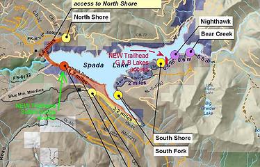 Spada Lake east.edtd  The South Shore site will be upgraded to a full boat launch site, replacing Nighthawk, and a trailhead parking area will be added.
I asked if it wouldn't just be cheaper to maintain another 0.8 miles of road, from South Shore to Nighthawk, rather than paying for all that new development ........ and was told that it would not!
The South Shore site will be upgraded to a full boat launch site, replacing Nighthawk, and a trailhead parking area will be added.
I asked if it wouldn't just be cheaper to maintain another 0.8 miles of road, from South Shore to Nighthawk, rather than paying for all that new development ........ and was told that it would not!  I spent some time after the meeting talking to Danny Miles (the engineer who raised Culmback Dam in 1982 and built the Recreation Areas) and he explained that the problem was the ........ errrr ....... fish. Because of current federal standards for forest road maintenance, several trivial streams that cross the South Shore Road in that 0.8 mile stretch would have to have 60 inch culverts replaced with 10 foot, fish friendly culverts ....... and that would cost more than all the other redevelopment plans put together. .......... He felt about it pretty much the way I do.
  During the meeting, I also bit the bullet and asked about the prohibtion on landing on the north shore. I pointed out that people could boat on the lake and go pretty much anywhere along the south shore, and also hike through the woods on the north shore, so that ........ and here I spread me arms to indicate a distance ....... only a space of about "so much" was actually off limits, and I asked if anyone could explain why that should be?
I was told that, "the north shore banks were steep" and that "they were clayey" and that "no one would want to go there anyway". ....... Right.
During the meeting, I also bit the bullet and asked about the prohibtion on landing on the north shore. I pointed out that people could boat on the lake and go pretty much anywhere along the south shore, and also hike through the woods on the north shore, so that ........ and here I spread me arms to indicate a distance ....... only a space of about "so much" was actually off limits, and I asked if anyone could explain why that should be?
I was told that, "the north shore banks were steep" and that "they were clayey" and that "no one would want to go there anyway". ....... Right.  In connection with that, I ran into a contradiction that I don't like. At the DNR "Future of Recreation" meeting last month, I'd asked why DNR's access policies differed from those of the Forest Service and the National Parks, and was told that they didn't, that people could go on foot wherever they wanted to. Today I was told the opposite, that DNR had the right to restrict access in the NRCA's, and often did so. ........ I hope we can get a positive resolution to that one.
One final point is really Andy's. He asked about the status of road 72, the North Shore - Williamson Creek Road. The DNR representative told him that it had been decommisioned; it was no longer a road. It also was not a trail. ........ It was "landscape"!
In connection with that, I ran into a contradiction that I don't like. At the DNR "Future of Recreation" meeting last month, I'd asked why DNR's access policies differed from those of the Forest Service and the National Parks, and was told that they didn't, that people could go on foot wherever they wanted to. Today I was told the opposite, that DNR had the right to restrict access in the NRCA's, and often did so. ........ I hope we can get a positive resolution to that one.
One final point is really Andy's. He asked about the status of road 72, the North Shore - Williamson Creek Road. The DNR representative told him that it had been decommisioned; it was no longer a road. It also was not a trail. ........ It was "landscape"!   (Take your choice.)
One final, final point: Kudos to the Snohomish County PUD. Year after year I find them to be everything you think "public servants" ought to be, but almost never are, except in Everett and Sultan and ......... friendly and informative and helpful. ......... Thanks folks. (Take your choice.)
One final, final point: Kudos to the Snohomish County PUD. Year after year I find them to be everything you think "public servants" ought to be, but almost never are, except in Everett and Sultan and ......... friendly and informative and helpful. ......... Thanks folks. 
Something lost behind the ranges. Lost and waiting for you....... Go and find it. Go!
Something lost behind the ranges. Lost and waiting for you....... Go and find it. Go!
|
| Back to top |
  
|
|
Backpacker Joe
Blind Hiker

Joined: 16 Dec 2001
Posts: 23956 | TRs | Pics
Location: Cle Elum |
Great write up Scrooge. Question, what's Nighthawk?
"If destruction be our lot we must ourselves be its author and finisher. As a nation of freemen we must live through all time or die by suicide."
Abraham Lincoln
"If destruction be our lot we must ourselves be its author and finisher. As a nation of freemen we must live through all time or die by suicide."
Abraham Lincoln
|
| Back to top |
|
|
Scrooge
Famous Grouse

Joined: 16 Dec 2001
Posts: 6966 | TRs | Pics
Location: wishful thinking |
|
Scrooge
Famous Grouse
|
Thu Sep 25, 2008 4:54 pm |
|
|
Nighthawk is the main recreation area at the east end of Spada Lake, the one with the boat ramp that'll get you into the lake most of the year. Also an amazing collection of underutilized picnic areas, including a number of covered sites.
When it was new, and the PUD could afford to maintain it, it was truly a class act.
edit - When we get that map, the relationships will be obvious.
Something lost behind the ranges. Lost and waiting for you....... Go and find it. Go!
Something lost behind the ranges. Lost and waiting for you....... Go and find it. Go!
|
| Back to top |
|
|
Dogpatch
Member

Joined: 17 Aug 2003
Posts: 1588 | TRs | Pics
Location: the dryside |
|
Dogpatch
Member
|
Thu Sep 25, 2008 5:05 pm |
|
|
Hey, me and Campking were at that meeting too - although we left a little after the break and didn't stay for the whole thing. Thanks to Sultan Guy for posting the meeting info here. And Scrooge, I wholeheartedly second your thanks to the PUD. They are definitely picking up the slack here, and trying to maintain some road access into the area.
I also asked about the North Shore road being reopened. Their map of proposed recreational sites included a North Shore access across Culmback Dam. In a wild flight of fancy, I thought that meant they were going to restore access to Williamson Creek. But they're actually planning to reopen the road as a 1.5-mile long trail to the old North Shore viewpoint (which I've never been to). And not any further than that - no surprise there, I guess.
During the break, I asked a woman from the DNR about regulations for the National Resource Conservation Areas (since the Morningstar NRCA covers a huge area up there). She kindly got some brochures for us - apparently the Cutthroat Lakes area is in the NRCA now, too, as is the Bald Mountain Trail area.
Sounds like the PUD is also going to provide parking and access to a trail that leads down into the Sultan River gorge from the dam.
At any rate, they are to be applauded for keeping the South Shore road open. A 2-mile road walk to Greider Lakes trailhead is a drag, but it could be a lot worse.
"Outside of a dog, a book is man's best friend.
Inside of a dog, it's too dark to read." Groucho Marx
"Outside of a dog, a book is man's best friend.
Inside of a dog, it's too dark to read." Groucho Marx
|
| Back to top |
|
|
Backpacker Joe
Blind Hiker
Joined: 16 Dec 2001
Posts: 23956 | TRs | Pics
Location: Cle Elum |
Did anyone ever ask WHY there is any access to Spada at all? There isn't access to the Chester Morris, or Tolt or any other water shed I know of. Just curious.
"If destruction be our lot we must ourselves be its author and finisher. As a nation of freemen we must live through all time or die by suicide."
Abraham Lincoln
"If destruction be our lot we must ourselves be its author and finisher. As a nation of freemen we must live through all time or die by suicide."
Abraham Lincoln
|
| Back to top |
|
|
Hulksmash
Cleaning up.

Joined: 20 Apr 2008
Posts: 7113 | TRs | Pics
Location: Arlington |
|
Hulksmash
Cleaning up.
|
Thu Sep 25, 2008 5:24 pm |
|
|
I'm relieved to hear that the whole south shore road is not going. But this plan makes Boulder Lake at about a 14mile round trip. This is out of range for most people to do a day hike. Grider lakes will be around 9 miles. Granted this is a vast improvement over hiking in from Onely Pass. I have a feeling that Boulder Lake trail will fall into disrepair  Grider lakes will most likely be a lonely area as well. Grider lakes will most likely be a lonely area as well.
"Bears couldn't care less about us....we smell bad and don't taste too good. Bugs on the other hand see us as vending machines." - WetDog
Albuterol! it's the 11th essential
"Bears couldn't care less about us....we smell bad and don't taste too good. Bugs on the other hand see us as vending machines." - WetDog
Albuterol! it's the 11th essential
|
| Back to top |
|
|
Sabahsboy
Member

Joined: 18 Jul 2006
Posts: 2484 | TRs | Pics
Location: SW Sno County |
Scrooge, many thanks for your persistent attention to this very favored area. And, the frequent updates.
As an aging person, the ever longer trails will make access prohibitive...and that goes for all the Boomers who are aging and soon retiring....and looking to hike, fish, etc. Boulder Lake Trail was hard enough for me two years ago, now would be near impossible...and, it appears, unlikely or even illegal since the trail is not built from Grieder Lakes TH and the road is officially closed (to every walker?) plus the elimination (sans humour! LOL!) of the permanent potty at old Boulder Lake TH. What a shame...it was a nice spot to park and dump and head up the trail...and the lovely bridge over the creek was worth the destination of itself, though so very close to the TH.
Nice to know one public agency has not blinded itself and is open to good thinking and working out planning and sharing landscape with more than fish. I find the 10' dia. culvert ludicrous...unless the fish are whale size. A series of 60" (huge) culverts would seem amazing. All that needs be done is allow free flow of stream and passage under the road. The 10' dia. culvert means road base would need be rebuilt, thus the extravagant costs...all unnecessary and a ploy to divert attention toward the intentions of the Spada people. What they want is $$$$ for their projects and abandonment of all recreation in the area, using any number of excuses or "pitches" whether dealing with "9/11", National Security, Water Rights, Fish Rights, Insect Rights, Pure Water, and an endless set of created excuses.
Mismanagement is mismanagement...observe Wall Street! A shared resource is a happy resource with happy users willing to care about it. Except the "yahoos" (not of the now defunk WaMU sort) that go up Spada way to run around and shoot at any log or Coke can or beer bottle and leave the trash. A little policing goes a long way (written about in today's P-I of the area just north of the Public Market where Wild West social culture seemed to rule streat life and smack into residents, many in high end high rise buildings).
I think the State needs to step in and call "foul" and organize the planning into a more uniform beast. Maybe the Fed, since some of the lands are Federal...certainly the watershed has plenty of Fed land (National Forest).
As far as I know, boats are still running wild on Lake Mead and Lake Powell and no one is curbing excessive recreation, campers, hikers, boaters (and should...the carbon footprint of those monsters...etc!).
Ah, but the tiny mini-minnow darter of upper reaches-fork of the fork of the north fork of the east fork of the Spada drainagfe cum Sultan must be saved at all costs...even if it was created in a lab to be released to prove a point! LOL!
Sucks! That is what I say! Sucks!
|
| Back to top |
|
|
Backpacker Joe
Blind Hiker
Joined: 16 Dec 2001
Posts: 23956 | TRs | Pics
Location: Cle Elum |
The Boulder toilet was still there as of August 8th. Speaking of boulder....
I did Boulder one day and then came back for Grieders the next day. Between the two I liked Boulder best.
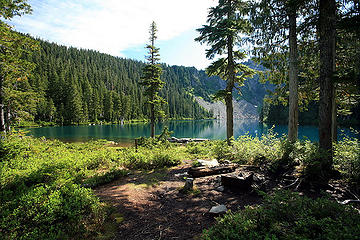 Boulder lake 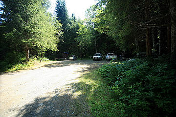 Boulder lake trailhead
"If destruction be our lot we must ourselves be its author and finisher. As a nation of freemen we must live through all time or die by suicide."
Abraham Lincoln
"If destruction be our lot we must ourselves be its author and finisher. As a nation of freemen we must live through all time or die by suicide."
Abraham Lincoln
|
| Back to top |
|
|
Dogpatch
Member
Joined: 17 Aug 2003
Posts: 1588 | TRs | Pics
Location: the dryside |
|
Dogpatch
Member
|
Thu Sep 25, 2008 5:37 pm |
|
|
| Sabahsboy wrote: | | Boulder Lake Trail was hard enough for me two years ago, now would be near impossible...and, it appears, unlikely or even illegal since the trail is not built from Grieder Lakes TH and the road is officially closed (to every walker?) |
Boulder Lake: I agree, unlikely, with the additional distance. But not illegal - the road from Greider to Boulder will be open to bikes and hikers.
One thing that struck me at the meeting - there were plenty of reps from various use groups - kayakers, miners, the various agencies, etc. But not any reps from hiking groups. We need to get organized and vocal!
"Outside of a dog, a book is man's best friend.
Inside of a dog, it's too dark to read." Groucho Marx
"Outside of a dog, a book is man's best friend.
Inside of a dog, it's too dark to read." Groucho Marx
|
| Back to top |
|
|
Backpacker Joe
Blind Hiker
Joined: 16 Dec 2001
Posts: 23956 | TRs | Pics
Location: Cle Elum |
Isn't that funny (peculiar, as opposed to funny ha ha) no hiker representation. It seems to me that the hiker population would out number all others combined, and yet no representation......
"If destruction be our lot we must ourselves be its author and finisher. As a nation of freemen we must live through all time or die by suicide."
Abraham Lincoln
"If destruction be our lot we must ourselves be its author and finisher. As a nation of freemen we must live through all time or die by suicide."
Abraham Lincoln
|
| Back to top |
|
|
Hulksmash
Cleaning up.
Joined: 20 Apr 2008
Posts: 7113 | TRs | Pics
Location: Arlington |
|
Hulksmash
Cleaning up.
|
Thu Sep 25, 2008 5:41 pm |
|
|
Now if i remember correctly there are a bunch of bever dams, in the area beween the southshore site, and night hawk...do the bever's need a EIS before blocking fish passage?
"Bears couldn't care less about us....we smell bad and don't taste too good. Bugs on the other hand see us as vending machines." - WetDog
Albuterol! it's the 11th essential
"Bears couldn't care less about us....we smell bad and don't taste too good. Bugs on the other hand see us as vending machines." - WetDog
Albuterol! it's the 11th essential
|
| Back to top |
|
|
33teeth
Member

Joined: 25 Aug 2008
Posts: 420 | TRs | Pics
|
|
33teeth
Member
|
Thu Sep 25, 2008 7:27 pm |
|
|
The resolution (as it stands) isn't ideal, but is better than what was in store for us. Thanks to those of you who aren't to busy or lazy (and are informed enough) to fight the good fight. It's appreciated.
|
| Back to top |
|
|
Scrooge
Famous Grouse
Joined: 16 Dec 2001
Posts: 6966 | TRs | Pics
Location: wishful thinking |
|
Scrooge
Famous Grouse
|
Thu Sep 25, 2008 7:44 pm |
|
|
Dogpatch said | Quote: | | One thing that struck me at the meeting - there were plenty of reps from various use groups - kayakers, miners, the various agencies, etc. But not any reps from hiking groups. We need to get organized and vocal! |
Ah, but Dogpatch, you and CampKing were sitting next to me, so hikers were represented. SultanGuy was there, representing both kayakers and hikers. There was a lady from the National Park Service, Susan Rosebrough, who's job is to "represent the public" at such meetings, and the public is us. I believe one other lady was a hiker, so in fact we were represented better than usual.
However, there are some DNR public meetings coming up and Sultan Guy will be on your case about that - all of you! He mentioned to me, today, that one of the reasons the kayakers have gotten so many concessions made is that early in the meeting process they had 20 or 30 people attending, and that really shocked the bureaucrats. We expect that you here on nwhikers will give us a similar turnout when the time comes. ........ You can count on us letting you know.  Quite an amazing amount can be achieved, if we maintain a high profile. Start coming to some of these meetings. Talk to the land managers and their assistants. Get on their mailing lists. Get their business cards and drop them an email, just reminding them that you met.
You too may be able to rescue some cherished area or right from the dissolution of our society.
Quite an amazing amount can be achieved, if we maintain a high profile. Start coming to some of these meetings. Talk to the land managers and their assistants. Get on their mailing lists. Get their business cards and drop them an email, just reminding them that you met.
You too may be able to rescue some cherished area or right from the dissolution of our society. 
Something lost behind the ranges. Lost and waiting for you....... Go and find it. Go!
Something lost behind the ranges. Lost and waiting for you....... Go and find it. Go!
|
| Back to top |
|
|
Scrooge
Famous Grouse
Joined: 16 Dec 2001
Posts: 6966 | TRs | Pics
Location: wishful thinking |
|
Scrooge
Famous Grouse
|
Thu Sep 25, 2008 8:10 pm |
|
|
Something lost behind the ranges. Lost and waiting for you....... Go and find it. Go!
|
| Back to top |
|
|
Dogpatch
Member
Joined: 17 Aug 2003
Posts: 1588 | TRs | Pics
Location: the dryside |
|
Dogpatch
Member
|
Thu Sep 25, 2008 8:33 pm |
|
|
| Scrooge wrote: | | Ah, but Dogpatch, you and CampKing were sitting next to me, so hikers were represented. SultanGuy was there, representing both kayakers and hikers. |
Nice to meet cha.  It's good there were hikers there, for sure.
I'm still a little curious about official hiker representation on that committee, though. I downloaded a document from the PUD website that listed the committee members - there were members from two biking associations, three separate mining concerns, two kayaking associations, and bunches of government agencies. They also listed WTA and Everett Mountaineers, but the slot for the member name was blank. So I think we're pretty darn lucky we've had Sultan Guy looking after our interests. It's good there were hikers there, for sure.
I'm still a little curious about official hiker representation on that committee, though. I downloaded a document from the PUD website that listed the committee members - there were members from two biking associations, three separate mining concerns, two kayaking associations, and bunches of government agencies. They also listed WTA and Everett Mountaineers, but the slot for the member name was blank. So I think we're pretty darn lucky we've had Sultan Guy looking after our interests.
"Outside of a dog, a book is man's best friend.
Inside of a dog, it's too dark to read." Groucho Marx
"Outside of a dog, a book is man's best friend.
Inside of a dog, it's too dark to read." Groucho Marx
|
| Back to top |
|
|
|
|
You cannot post new topics in this forum
You cannot reply to topics in this forum
You cannot edit your posts in this forum
You cannot delete your posts in this forum
You cannot vote in polls in this forum
|
Disclosure: As an Amazon Associate NWHikers.net earns from qualifying purchases when you use our link(s). |


 So the f****ng (literally) fishies will have a place to do it (if they choose to do it under the road).